Showing 158 items
matching topographical
-
 Bendigo Military Museum
Photograph - 4th Field Survey Squadron – Operation MIZMAZE 92, Kimberley region, Western Australia, 1992
This is a set of 40 photographs taken in 1992 during 4th Field Survey Squadron’s deployment on Operation MIZMAZE 92 in the Kimberley region of Western Australia from the 13th of May to the 14th of July 1992. The area of operations was Wyndham, Halls Creek and Sandfire Flat. It was a two-part operation involving the field completion of topographic maps and the acquisition of mapping control by GPS field parties utilising Texas Instruments TI4100 Global Positioning System receivers. Survey parties conducted field checking of topographic maps and GPS control acquisition in Perentie 110 Series Survey variant FFR Land Rovers. Three Bell Kiowa LOH helicopters provided by 162 Recce Sqn supported field checking and limited deployment of GPS surveys parties. C-l30 Hercules from 36 Sqn supported deployment and extraction of personnel and equipment to and from from the AO. A Cessna 404 Titan Ambassador from Vee-H Aviation was used as the Wild RC10 camera platform for aerial photography acquisition.This is a set of 40 photographs taken in 1992 during 4th Field Survey Squadron’s deployment on Operation MIZMAZE 92 in the Kimberley region of Western Australia. The colour photographs are on 35mm negative film and are part of the Army Survey Regiment’s Collection. The photographs were scanned at 96 dpi. .1) - Photo, colour, 1992. CAPT Craig Hersant. .2) - Photo, colour, 1992. Unidentified officer/soldier. .3) & .4) - Photo, colour, 1992. Aboriginal rock art - Wandjina Gunduran, Donkey Creek. .5) - Photo, colour, 1992. Aboriginal rock art - Track Wandjinas, Donkey Creek. .6) & .7) - Photo, colour, 1992. CAPT Craig Hersant. .8) - Photo, colour, 1992. Kimberley region topography. CPL Glen Weatherell. .9) - Photo, colour, 1992. Unidentified personnel .10) - Photo, colour, 1992. Supermarket at unknown location. .11) to .13) - Photo, colour, 1992. Caravan park at unknown location. .14) - Photo, colour, 1992. Old bridge at Fitzroy Crosssing. .15) & .16) - Photo, colour, 1992. Survey party in Perentie 110 Series Land Rover. .17) & .18) - Photo, colour, 1992. Kimberley region topography. .19) - Photo, colour, 1992. Kimberley region topography. CPL Glen Weatherell. .20) - Photo, colour, 1992. Kimberley region topography, possibly the Bungle Bungles. .21) - Photo, colour, 1992. Kimberley region topography. SGT Frank Downie. .22) - Photo, colour, 1992. Kimberley region topography: the Bungle Bungles. .23) - Photo, colour, 1992. Kimberley region topography: the Bungle Bungles. .24) - Photo, colour, 1992. Kimberley region topography: the Bungle Bungles. SPR Neil Pedler. .25) & .26) - Photo, colour, 1992. Kimberley region topography: the Bungle Bungles. .27) - Photo, colour, 1992. Kimberley region topography. .28) - Photo, colour, 1992. Survey party with Perentie 110 Series Land Rover. .29) - Photo, colour, 1992. Kimberley region topography. .30) - Photo, colour, 1992. Survey party outside Perentie 110 Series Land Rover. .31) & .32) - Photo, colour, 1992. Survey party operating TI4100 GPS Receiver next to Perentie 110 Series Land Rover. SGT Eddie Jacobs. .33) & .34) - Photo, colour, 1992. Survey party operating TI4100 GPS Receiver next to Perentie 110 Series Land Rover. Unidentified surveyor. .35) - Photo, colour, 1992. Kimberley region topography. Hand water pump at well. .36) - Photo, colour, 1992. Survey party in Perentie 110 Series Land Rover. .37) - Photo, colour, 1992. Kimberley region topography. CPL Glen Weatherell. .38) - Photo, colour, 1992. Kimberley region topography viewed from Bell Kiowa LOH helicopter. .39) & .40) - Photo, colour, 1992. Unidentified surveyor field checking a preliminary map in a Bell Kiowa LOH helicopter..1P to .40P – There are no personnel identified. ‘1992 OP MIZMAZE annotated on negative sleeve.royal australian survey corps, rasvy, 4 fd svy sqn, op mizmaze 92 -
 Wodonga & District Historical Society Inc
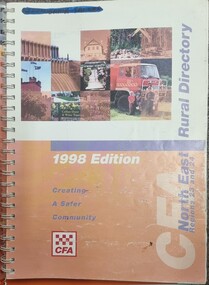
Book - North East Rural Directory 1998
The CFA North East Rural Directory for Regions 23 and 24 was designed to assist fire brigades and other emergency services in responding to calls in the North East region of Victoria. Its purpose was to minimize response times to emergency situations by providing accurate and detailed information about all of the localities in the regions. District 23 is based at Wangaratta and Extends as far south as Woods Point. District 24 is centred in Wodonga and extends past Corryong to the New South Wales border following the Murray River. It also includes Falls Creek and Mount Hotham.A spiral bound volume including colour topographic maps and illustrations of North East Victoria. The cover features a collage of colour photo of North East Victoria including a CFA firefighter in a truck with members of his family beside it. The book also features a key map, explanation of map references and symbols, localities index. Alphabetical road indexes for Wodonga, Albury, Wangaratta and Benalla as well as township maps and alphabetical road indexes for smaller communities are included.The CFA North East Rural Directory for Regions 23 and 24 was designed to assist fire brigades and other emergency services in responding to calls in the North East region of Victoria. Its purpose was to minimize response times to emergency situations by providing accurate and detailed information about all of the localities in the regions. District 23 is based at Wangaratta and Extends as far south as Woods Point. District 24 is centred in Wodonga and extends past Corryong to the New South Wales border following the Murray River. It also includes Falls Creek and Mount Hotham.emergency management north east victoria, cfa region 24, cfa wodonga, cfa region 23 -
 Bendigo Military Museum
Administrative record - Trilateration with the Tellurometer - GRL Rimington 1958, Department of National Development , ACT, 26 May 1958
trilateration with the tellurometer by GRL Rimington L.S MIS (Aust) Chief Topographic Surveyor, Department of National Development, Australia. This paper was delivered to the Institute of Surveyors Conference, Brisbane 26 May 1958. This paper is a summary of Electronic distance measurements carried out in 1957 in Central Australia by officers of the division of National Mapping, Department of National Development. Trilateration is a surveying Technique that uses measurements of the sides of triangles to determine relative position.A 11 page foolscap size stapled paper report. Two holed punched with dis-coloured pages due to age.royal australian survey corps, rasvy, fortuna, army survey regiment, army svy regt, asr, division of national mapping, surveying -
 Bendigo Military Museum
Photograph - Photogrammetric Equipment – Army Survey Regiment, Bendigo and School of Military Survey Bonegilla, c1960s to c1980s
This is a set of 14 photographs of RA Svy technicians operating photogrammetric equipment in Air Survey Squadron, Army Survey Regiment, Fortuna, Bendigo; and the School of Military Survey Bonegilla c1960s to c1980s. The Wild B9 stereo plotter were introduced in 1962 and the Wild B8 stereo plotter was introduced in 1966. The Wild B9 and B8 stereo plotters were used for plotting topographic detail and contours. These analogue machines were manually controlled by adjusting the control knobs for the orientation of the 3D image. The B9s used a four and a half square, and the B8s used a nine-inch square photo image on a film or glass diapositive which allowed highly accurate extraction of map features. At first, plotting with B8 and B9 stereo plotters was undertaken at the aerial photography scale of 1:80,000 in pencil onto a controlled plotting sheet. Sheets were then inked up and reduced photographically to the 1: 100,000 publication scale for scribe impression production. In the early days topographic detail and contours were plotted with a pencil or ink pen mounted at the far end of the pantograph arm. The plotting procedure was upgraded to direct plotting in ink with photographic reduction to publication scale. In 1975 four B8s were upgraded with tri-axis locaters as part of the Input Sub-system to enable digital extraction to AUTOMAP 1’s topographic database. When AUTOMAP 2 was introduced in 1982 these B8s were upgraded, and additional machines added to expand the Army Survey Regiment’s digital capture capability. There are several more photos catalogued in the Victorian Collections database of RA Svy personnel operating Wild B9 and B8 stereo plotters.Photogrammetric Equipment – Army Survey Regiment, Fortuna, Bendigo c.1981. . .7) – Unidentified technician operating Wild B8 stereo plotter in AUTOMAP 1 at ASR. .8) - Wild B8 stereo plotter in AUTOMAP 1 at ASR. Photogrammetric Equipment – Army Survey Regiment, Fortuna, Bendigo. c1981. .9) – ASR’s CPL Dave Cook in AUTOMAP 1 operating a Wild B8 stereo plotter. This is a set of 14 photographs of RA Svy technicians operating photogrammetric equipment at the Army Survey Regiment (ASR), Bendigo and the School of Military Survey (SMS) Bonegilla. c1960s to c1980s. The photographs are on 35mm colour slides and were scanned at 96 dpi. .1) - Photo, colour, c1964. Unidentified ASR technicians operating analogue Wild B9 stereo plotters. .2) - Photo, colour, c1974. ASR’s SPR Mick Minchin operating an analogue Wild B8 stereo plotter. .3) to .6) - Photo, colour, c1980. Photogrammetry Instructor SGT Neil ‘Ned’ Kelly at the SMS operating an analogue Wild B8 stereo plotter. .7) - Photo, colour, c1981. Unidentified technician operating Wild B8 stereo plotter in AUTOMAP 1 at ASR. .8) - Photo, colour, c1981. Wild B8 stereo plotter in AUTOMAP 1 at ASR. .9) to .14) - Photo, colour, c1981. ASR’s CPL Dave Cook in AUTOMAP 1 operating a Wild B8 stereo plotter..1P to .14P - Some of the equipment is annotated on the frame of the 35mm slides.royal australian survey corps, rasvy, army survey regiment, army svy regt, fortuna, asr, photogrammetry -
 Orbost & District Historical Society
book, Effingham, Wilson, A Geographical Dictionary of the Australian Colonies, 1848
A geographical dictionary or gazetteer of the Australian colonies : their physical and political geography : together with a brief notice of all the capitals, principal towns, and villages. William Wells travelled to Australia as a sponsored immigrant in 1838. Her became a freelance surveyor with an office in Bligh Street, Sydney. He wrote this book in order to better inform the British public on the colonies of Australia. The information contained in the book is both topographical and statistical and was a very useful refernece book at the time.This book is a rare detailed contemporary record of the Australian colonies in the mid 19th century.A hard back 453 pp book with a dark brown patterned cover which has a white label with the title, "Dictionary of Geography" over a map of Australia. It is illustrated with numerous maps and drawings.history-australia wells-william-henry geographical-dictionary-of-the-australian-colonies -
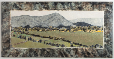 Nillumbik Shire Council
Mixed media: Liz NETTLETON, Liz Nettleton, Respite and Repose, 2010
Nettleton creates an image of peace and tranquility after the violence felt from the 2009 Black Saturday bush fires / At the Arthurs Creek cemetery Nettleton found the grave of Reg Evans and Angela Brunton, friends who had perished in the fires / Nettleton sat on the edge of their joint grave and photographed their view / It was only after examining the photos more closely that she realized Mount Sugarloaf had burnt almost to the valley / Sugarloaf is always in an indigo haze. This work is by a local contemporary artist and encompasses themes dealing with the 2009 Black Saturday bushfires. Mixed media (acrylic paint, acrylic ink and indian ink) on board / Landscape painting of Mount Sugarloaf and green pastures after the 2009 Black Saturday bushfires / Mount Sugarloaf is depicted in an indigo haze in the background / A line of trees bathed in light border the mountain's edge / Lines of trees parallel to each other jut out diagonally in the foreground / Framing this view of the landscape is a pattern (topographical maps of the Nillumbik area), which suggest the vast extent of the devastated area of landscape. In black marker 'LIZ NETTLETON' + artist signature '2011' on back - middle right side nettleton, respite and repose, landscape, painting, mixed media, black saturday, mount sugarloaf -
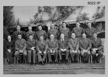 Bendigo Military Museum
Photograph - Commissioned Officers of the Army Survey Regiment, c1962-1965, 1972, c1973-1974
These photographs of Royal Australian Survey Corps commissioned officers was taken at the Army Survey Regiment circa 1962-1965, 1972 and circa 1973-1974. Officer appointments to the Army Svy Regt were typically the CO, 2IC, Adjutant; and an OC, 2IC and Troop Officers assigned to the Headquarters, Topographic/Air Survey, Cartographic and Lithographic Squadrons. RAN and RAAF liaison officers were usually appointed to the Regiment; and occasionally exchange officers from other Corps, the USA or UK.This is a set of photographs of RASvy Officers at the Army Survey Regiment, Bendigo. The photographs were printed on photographic paper and are part of the Army Survey Regiment’s Collection. The photographs were scanned at 300 dpi. .1) - Back row – L to R: Unknown Philippines officer, LT Merv Marks, LT Jorge Gruszka, LT Bill Greer, CAPT Peter Constantine, LT Freddy High, MAJ Brian Dalton.Front row – L to R: CAPT Carol Castor, MAJ NRJ Hillier, MAJ Bill Howarth, CO LTCOL Frank Buckland, DSVY-A COL Don Macdonald, GEN Miller – US Director Mapping, MAJ John Nolan, MAJ Eddy Anderson MBE, unknown UK Exchange Officer. .2) - Photo, black & white, c1972. Back row – L to R: CAPT Jack Gore, LT Royal, FLT Sinclair, LT Fred Brown, LT John Winzar, LT Gary Kenney, LT Reg Smith, 2LT Terry Edwards, LT Bob Roche. Front row – L to R: CAPT McNeale, 2LT William, MAJ Keith Todd, MAJ Don Ridge, LTCOL Bill Howarth, MAJ Brian Dalton, MAJ John Bullen, LT C. Chittleborough, LT Bailey .3) - Photo, black & white c1972. Back row – L to R: 1st 2LT Terry Edwards, 7th LT Gary Kenney, 9th LT Bob Roche. Front row – L to R: 1st CAPT Jack Gore, 3rd LT Bailey, 4th MAJ Keith Todd, 5th MAJ Don Ridge, 6th LTCOL Bill Howarth, 7th MAJ Brian Dalton, 8th MAJ John Bullen, 9th FLT Sinclair, 10th CAPT McNeale. .4) - Photo, black & white, c1972. Personnel named as per .3) .5) - Photo, black & white, c1973-1974. Back row – L to R: 1st LT Graham Baker, 4th MAJ John Sinclair , 7th CAPT Reg Smith, 8th LT Terry Edwards. Front row – L to R: 3rd MAJ Peter Constantine, 4th LTCOL Don Ridge 5th MAJ John Cattell. .6) - Photo, colour print of .5), c1973-1974 Personnel named as per .5).1 no annotation, .2 Personnel (surnames, no rank) annotated on back, .3 to .6 no annotationroyal australian survey corps, rasvy, army survey regiment, army svy regt, fortuna, asr -
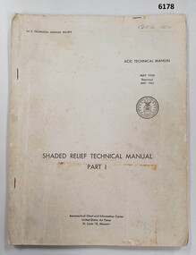 Bendigo Military Museum
Manual - Shaded Relief Technical Manual - United States Air Force, Department of the Air Force, USA, May 1958
This manual describes how to hand create "Shaded Relief" or the appearance of hills. This manual was produced by the Aeronautical Chart Information Centre, United States Air Force, St Louis 18, Missouri. Shaded relief was produced by hand at the Army Survey Regiment in the 50's, 60's and 70's so that it could be shown on small scale topographical maps and RAAF Aeronauical Charts. Shaded relief continued to be produced by hand until the mid 1980's when it was replaced by digital production methods.Grey covered Manual, gloss paper, stapled together.royal australian survey corps, rasvy, fortuna, army survey regiment, army svy regt, asr -
 Bendigo Military Museum
Photograph - 4th Field Survey Squadron deployed on Operation NERIGHT, Queensland & Northern Territory, 1989
This is a set of 19 photographs taken in 1989 during 4th Field Survey Squadron’s deployment on Operation NERIGHT 89 in Queensland and the Northern Territory. It was a two-part operation in 1989 with work conducted in the areas of Camooweal and Weipa. Part 1 was the field completion of topographic maps conducted near Camooweal QLD, along the Barkley Highway on the border between NT and QLD, from the 12th of September to the 20th of October 1989. A Bell Kiowa LOH helicopter from 162 Recce Sqn supported topographic field completion. Operation NERIGHT 89 Part 2 was the acquisition of mapping control by GPS field parties utilising Texas Instruments TI4100 Global Positioning System receivers around Weipa on Cape York Peninsula from the 22nd of September to the 22nd of October 1989. Part 2 Two Bell UH-1H Iroquois helicopters from RAAF’s 35 Squadron were principally used to deploy GPS field parties. Identification photography of control points was taken by air camera operators in AAAvn Pilatus Porter aircraft from 173 Gen Spt Sqn fitted with an RC10 aerial camera. The two parts of the operation were conducted concurrently. This is a set of 19 photographs taken in 1989 during 4th Field Survey Squadron’s deployment on Operation Neright in Queensland & the Northern Territory. The colour photographs are on 35mm negative film and are part of the Army Survey Regiment’s Collection. The photographs were scanned at 96 dpi. .1) to .3) - Photo, colour, 1989. En-route to areas of survey operations. .4) to .5) - Photo, colour, 1989. Unidentified personnel relax next to river/waterhole. .6) - Photo, colour, 1989. Two Bell UH-1H Iroquois helicopters from RAAF’s 35 SQN utilised in the movement of GPS parties. .7) to .9) - Photo, colour, 1989. Unidentified soldier practices repelling from a UH1H Iroquois helicopter. .10) - Photo, colour, 1989. Inside the cockpit of a UH1H Iroquois helicopter. .11) - Photo, colour, 1989. Field Party camp with GPS equipment in foreground. Unidentified soldier prepares a meal. .12) - Photo, colour, 1989. GPS antenna plumbed over a survey ground mark. Witness post on left. .13) & .14) - Photo, colour, 1989. Unknown Cape York Peninsula beaches. .15) & .16) - Photo, colour, 1989. Dramatic fire next to base camp. .17) - Photo, colour, 1989. Aboriginal rock art at unknown location. .18) - Photo, colour, 1989. Aboriginal rock art at unknown location. L to R: unidentified, SPR Andrew Quin. .19) - Photo, colour, 1989. Aboriginal rock art at unknown location. LT Chris Topovsek..1P to .19P – There are no personnel identified. ‘1989 OP NERIGHT’ annotated on negative sleeve.royal australian survey corps, rasvy, 4 fd svy sqn, op neright 89 -
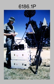
 Bendigo Military Museum
Photograph - Demonstration of TI4100 GPS Receiver, Royal Australian Survey Corps, c1988
This is a set of four photographs of WO2 Graham Ragless from the Royal Australian Survey Corps demonstrating the operation of Global Positioning System equipment in c1988. The photos were probably taken at the School of Military Survey (SMS), Bonegilla, VIC. Texas Instruments TI4100 portable Global Positioning System (GPS) geodetic receivers were introduced from 1986–1988. The GPS receivers and Ferranti FILS3 helicopter and vehicle mounted Inertial Positioning System (IPS) replaced the TRANSIT satellite receivers. The equipment was deployed to establish the baseline for a GPS controlled air camera and photogrammetric system to significantly reduce the requirement for ground survey to accurately control air photography for topographic mapping. Personnel from the four field survey squadrons at this time were trained at the SMS to operate the TI4100 receivers. Field survey operations using GPS and IPS equipment followed in the late 1980s. This technology is described in more detail in the RA Svy booklet titled An Introduction to Topographic Mapping. See record ID - 6010. WO2 Graham Ragless progressed to the rank of WO1 and was appointed as RSM of the Army Survey Regiment from 1990 to 1992. Refer to item 6186.2P for more photographs of WO2 Graham Ragless demonstrating the TI4100.This is a set of four photographs of a technician from the Royal Australian Survey Corps demonstrating the operation of Global Positioning System equipment in c1988. Colour photos are on 35mm slide film and were scanned at 96 dpi. .1) to .4) - Photo, colour, c1988, WO2 Graham Ragless demonstrating the operation of a TI4100 GPS receiverThere are no annotations.royal australian survey corps, rasvy, army survey regiment, army svy regt, fortuna, asr, surveying -
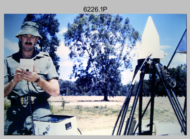
 Bendigo Military Museum
Photograph - Demonstration of TI4100 GPS Receiver, Royal Australian Survey Corps, c1988
This is a set of two photographs of WO2 Graham Ragless from the Royal Australian Survey Corps demonstrating the operation of Global Positioning System equipment in c1988. The photos were probably taken at the School of Military Survey (SMS), Bonegilla, VIC. Texas Instruments TI4100 portable Global Positioning System (GPS) geodetic receivers were introduced from 1986–1988. The GPS receivers and Ferranti FILS3 helicopter and vehicle mounted Inertial Positioning System (IPS) replaced the TRANSIT satellite receivers. The equipment was deployed to establish the baseline for a GPS controlled air camera and photogrammetric system to significantly reduce the requirement for ground survey to accurately control air photography for topographic mapping. Personnel from the four field survey squadrons at this time were trained at the SMS to operate the TI4100 receivers. Field survey operations using GPS and IPS equipment followed in the late 1980s. This technology is described in more detail in the RA Svy booklet titled An Introduction to Topographic Mapping. See record ID - 6010. WO2 Graham Ragless progressed to the rank of WO1 and was appointed as RSM of the Army Survey Regiment from 1990 to 1992. Refer to item 6226.4P for more photographs of WO2 Graham Ragless demonstrating the TI4100.This is a set of two photographs of a technician from the Royal Australian Survey Corps demonstrating the operation of Global Positioning System equipment in c1988. Colour photos are on 35mm slide film and were scanned at 96 dpi. .1) and .2) - Photo, colour, c1988, WO2 Graham Ragless demonstrating the operation of a TI4100 GPS receiverThere are no annotations.royal australian survey corps, rasvy, army survey regiment, army svy regt, fortuna, asr, surveying -
 Bendigo Military Museum
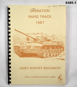
Administrative record - Army Survey Regiment - Operation Rapid Track 1987 Operation Report, Army Survey Regiment, Bendigo, 27 May 1987
The Survey Operation Report deals with the cartographic completion of four 1:50,000 topographical line maps and one Special 1:50,000 map covering the Puckapunyal Military Training Area. The report covers in detail the digital stereo plotting, field completion (checking) and the cartographic completion including printing. The four 1:50.000 maps are 7823-1 PYALONG, 7824-2 COSTERFIELD, 7923-4 TALLAROOK and 7924-3 NAGAMBIE. Annex A lists personnel and dates involved and is attached as 6385.2. Annex B lists the members of the field completion parties.A4 sized buff coloured light cardboard covered report, plastic spiral binding. Front cover includes text, Survey Corps badge and light brown image of a Centurian tank. "To Tech Library", Page 2 has two small handwritten notes indicating that Phase 2 was the Field Completion Phaseroyal australian survey corps, rasvy, fortuna, army survey regiment, army svy regt, asr -
 Bendigo Military Museum
Document - Army Survey Regiment Manning Chart 1976, 1976
This document contains detailed photocopies of reports of Army Survey Regiment’s staff manning from December 1975 to August 1976. Each monthly report provided to Directorate of Survey covered the allocation of staff to Regimental Headquarters and its four sub units comprising Headquarters, Air Survey (Topographic), Cartographic and Lithographic Squadrons. Each Squadron’s troop or section structure was represented by a wire diagram with soldiers and/or civilians names assigned to rank based established positions. A detailed table at the end of each report sumarised Army Survey Regiment’s posted strength by employment category and rank.Manilla cardboard folder containing 83 photocopied pages of staff posted to the Army Survey Regiment. Pages are fixed to the folder by a metal fastener. The title of the folder is written in black ink on a green tape background.royal australian survey corps, rasvy, army survey regiment, army svy regt, asr, fortuna -
 City of Ballarat
Artwork, other - Public Artwork, Cliff Burtt, Buninyong Bivium, 2016
Buninyong Bivium (2016) by Cliff Burtt engages with the geography and history of the Buninyong region in both pre and post settlement. The town of Buninyong is dominated by the profiles of Mt Helen and the extinct volcano Mt. Buninyong. Traditional land of the Wadawurrung people, today the area remains a significant site for the culture of indigenous people and their connection to the land. The profile of this sculpture is based on topographical mapping of the area, depicting sections of the landscape. The gaps between the elements of the work can be viewed as representations of the shafts sunk into the earth by the early gold miners and compound curves on the upper surfaces are mirroring the topography of the area, while cut-aways in the sides are suggestive of rock strata.The artwork is of aesthetic and social significance to the people of BallaratCorten steel sculpture made of five unique sculptural pieces secured to at concreate base at pavement levelbuninyong, cliff burtt, sculpture, public art, mining, ballarat -
 Department of Energy, Environment and Climate Action
Zeiss Sketchmaster
The Zeiss Sketchmaster was used to transfer information from aerial photographs onto scale maps. The operator views the aerial photograph and the map simultaneously and manually traces detail from the photograph onto the map. It utilises the principle of the camera lucida, patented in 1806. Various lens combinations were used on a to adjust for scale and then “rubber sheet” the image to line up topographic features like streams and roads. The photo information was then laboriously transferred using a light table onto large A0 paper maps or translucent drafting film. The maps were later hand coloured with either Derwent pencils or delicately painted with Pelikan ink wash. This item is kept at Erica.Zeiss Sketchmaster. c1970s. Includes adjustable stand, various lens in sperate box, adjustable light, map holder and magnetsforests commission victoria (fcv), forest measurement, mapping, surveying -
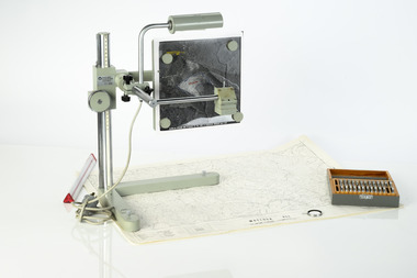
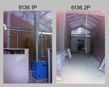
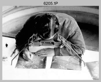
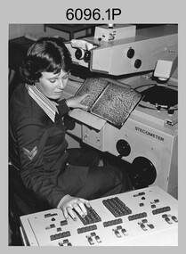 Bendigo Military Museum
Photograph - Army Survey Regiment – Map Production, Fortuna, Bendigo, c1980s
These five photographs of map production and the car park area were taken at Fortuna, Bendigo, c1980s. The first three photographs were taken in Air Survey Squadron, where aerotriangulation and digital photogrammetric extraction of topographic features from aerial photography were undertaken. Photo .4P was taken in Cartographic Squadron’s Correcting Section, located in the Attic. The technicians were probably involved in a rapid response map production, as they all were wearing field uniforms. The Army Survey Regiment’s Duty Room, RAP and Carpark appear in Photo .5P. It was probably taken from the top steps near the SGT’s accommodation block in 1986. Photos .4P and .5P are also published with item 6395.17P.This is a set of five photograph of Map Production and car park, at the Army Survey Regiment, Fortuna, Bendigo, c1980s. The photographs were printed on photographic paper and is part of the Army Survey Regiment’s Collection. Photograph .1P was scanned at 200 dpi. The others were scanned at 300 dpi. .1) - Photo, black & white, c1980s: CPL Marrianne (Van De Zee) De Groot measuring aerial photographs with a stecometer. .2) - Photo, colour, c1980s: Two unidentified technicians assessing a flight line diagram. .3) - Photo, black & white, c1980s: SPR Scheryl Delforce digitising map features on an AUTOMAP 1 Graticon table. .4) - Photo, black & white, 1986: L to R: CPL Andy Lucas, SPR Chris Gordon, unidentified, SPR Jan (Crighton) Minchin, SPR Robin Marshall, CPL Frank Downie, SPR Gayle Humphrey, unidentified technicians in the Attic, Fortuna. .5) - Photo, black & white, 1986: Army Survey Regiment Duty Room, RAP and Carpark at Fortuna. .1P - Annotated on back ‘Maryanne Degroot’ .2P, .4P to .5P – no annotation .3P - Annotated on back ‘Scheryl Delforce’royal australian survey corps, rasvy, army survey regiment, army svy regt, fortuna, asr, air survey, carto, aerotrig -
 Bendigo Historical Society Inc.
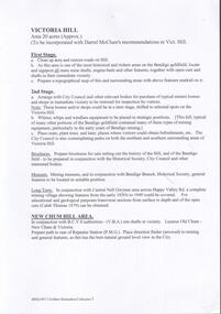
Document - VICTORIA HILL - VISITOR PLANS FOR VICTORIA HILL
Handwritten carbon copy and typed copy of notes on 1st and 2nd stage plans for a tourist area on approx. 20 acres at Victoria Hill. First stage was to clean up the area, locate and sign post shafts, engine beds, etc and prepare a topographical map with these features on it. Second stage was to arrange for the purchase of typical miners homes and shops in the vicinity to be restored for inspection by visitors. Mining equipment to be placed in the area. Prepare brochures for sale. Set up a mining museum.Prepare an area near BCV 8 with direction finder to mining and general features, as this has the best natural ground level view in the City. Notes prepared by Albert Richardson.mine, gold, victoria hill, victoria hill, visitor plans for victoria hill, darrel mcclure, bendigo city council, bendigo historical society, central nell gwynne, caleb thomas, bcv 8, lazarus, old chum, new chum, victoria, repeater station (p. m. g.) -
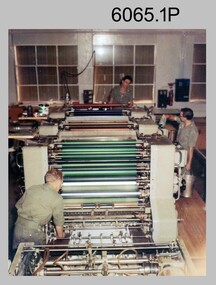 Bendigo Military Museum
Photograph - Ultra-MAN-III Printing Presses operating at the Army Survey Regiment, c1970s to c1980s
These ten photographs of the Ultra-MAN-III Printing Presses were probably taken circa 1970s to 1980s in Lithographic Squadron at the Army Survey Regiment, Fortuna, Bendigo. Although most photos are not annotated except for photos .1, .3P, .6P; most personnel are positively identified. The two Ultra-MAN-III Printing Presses were made in Germany at a standard map size format and introduced in June 1962 as a two-colour offset press with improved safety features. With an upgrade to a third colour deck in 1968, productivity greatly improved as the two presses could print a five colour standard topographic map in two passes, rather than the three passes before their upgrade. They were replaced with a single Heidelberg Speedmaster 102 five colour Printing Press in 1990. c1970s to c1980s.This is a set of photographs of the Ultra-MAN-III Printing Press operational at the Army Survey Regiment, Bendigo c1970s to c1980s. The photographs were printed on photographic paper and are part of the Army Survey Regiment’s Collection. The photographs were scanned at 300 dpi. .1) - Photo, colour, c1970s, L to R: Morgan, Mulqueen, Cook, Lithographic Squadron .2) - Photo, black & white, c1980s, unidentified, Lithographic Squadron .3) - Photo, black & white, c1980s, Ken Slater, Lithographic Squadron .4) - Photo, black & white, c1980s, L to R: Kim Reynolds, Terry Winzar, Lithographic Squadron .5) - Photo, black & white, c1980s, Lithographic Squadron .6) - Photo, black & white, c1980s, L to R: Steve Egan, unidentified, Jim Cook, Lithographic Squadron .7) - Photo, black & white, c1980s, Kim Reynolds, Lithographic Squadron .8) - Photo, black & white, c1980s, Roy Hicks, Lithographic Squadron .9) - Photo, black & white, c1980s, Lithographic Squadron .10) - Photo, black & white, c1980s, Colin Yeats, Lithographic Squadron.1, .3P, .6P – personnel annotated 2P, .4P to .5P, .76P to .10P – no annotation royal australian survey corps, rasvy, army survey regiment, army svy regt, fortuna, asr, printing, litho -
 National Vietnam Veterans Museum (NVVM)
Map - Maps, topographical
Standard issue items as used by Australian servicemen during the war in Vietnam.Set of 18 declassified US produced maps of various regions within South Vietnam. 1. Bien Hoa, Sheet 6330, Edition 4 2. Bien Hoa, Sheet 6330, Edition 4 3. Nhon Trach, Sheet 6330, Edition 3 4. Nhon Trach, Sheet 6330, Edition 3 5. Can Guioc, Sheet 6330, Edition 3 6. Can Guioc, Sheet 6330, Edition 3 7.Ho Chi Minh city, Sheet 6330, Edition 5 8.Ho Chi Minh city, Sheet 6330, Edition 5 9. Tan Uyen, Sheet 6331, Edition 3 10. Ben Cat, Sheet 6331, Edition 2 11. Phuoc Vinh, Sheet 6331, Edition 3 12. Xom Ruong, Sheet 6331, Edition 3 13. Cho Phuoc Hai, Sheet 6429, Edition 4 14. Xa Vung Tau, Sheet 6429, Edition 3 15. Xa Cam My, Sheet 6430, Edition 2 16.Xuyen Moc, Sheet 6430, Edition 3 17. Xa Binh Ba, Sheet 6430, Edition 2 18. Xa Xuan Loc, Sheet 6430, Edition 2 map, vietnam map, topographical, bien hoa, nhon trach, can guioc, tan uyen, ho chi minh city, phuoc vinh, ben cat, xom ruong, cho phuoc hai, xa cam my, xa binh ba, xa xuan loc, xuyen moc, xa vung tau, binh ba, vung tau -
 Bendigo Military Museum
Photograph - New Printing Press, Lithographic Squadron – Army Survey Regiment, Fortuna, Bendigo, 1990
This is a set of 30 photographs of contractors installing the Army Survey Regiment’s new Heidelberg Speedmaster 102 printing press in Lithographic Squadron’s purpose-built printing building at Fortuna, Bendigo in 1990. The computer-controlled five colour lithographic offset printing press provided the Royal Australian Survey Corps vastly improved printing capability, as the five colours for a standard topographic map was printed in a single pass. The print room was named Wayzgoose Hall after a medieval printing house festival. Wayzgoose Hall and the Speedmaster printing capability was commissioned by the Commander of the 3rd Military District BRIG P. Davies AM, ADC on Wednesday 27th June 1990. This occasion is covered in more detail in page 145 of Valerie Lovejoy’s book 'Mapmakers of Fortuna – A history of the Army Survey Regiment’ ISBN: 0-646-42120-4.This is a set of 30 photograph of the Heidelberg Speedmaster 102 Printing Press installation in Lithographic Squadron, Army Survey Regiment at Fortuna, Bendigo, 1990. The photographs were on 35mm colour negative film and were scanned at 96 dpi. They are part of the Army Survey Regiment’s Collection. No personnel are identified. Annotated with date on negative sleeve.royal australian survey corps, rasvy, army survey regiment, army svy regt, fortuna, asr, litho, printing -
 Bendigo Military Museum
Photograph - 4th Field Survey Squadron – Operation ARIGHT 93, Queensland, 1993
This is a set of 42 photographs taken during 4th Field Survey Squadron’s deployment on Operation ARIGHT 93 in North Queensland from the 30th of August to the 8th of October 1993. The Survey Field Completion area of operations was Weipa near the top end of the Cape York Peninsula. Survey parties conducted field checking of topographic maps covering Bamaga, Heathlands, Weipa, Lockhart River and Strathgordon in Perentie 110 Series Survey variant FFR Land Rovers. Hand-held Trimble and Magellan GPS receivers were used to assist with navigation and to position remote isolated features. Three Bell Kiowa LOH helicopters provided by 162 Recce Sqn supported field checking operations. Supplementary and Vital Asset Protection photography was taken by air camera operators in AAAvn Nomad aircraft from 173 Survl Sqn fitted with an RC10 aerial camera.This is a set of 42 photographs taken in 1993 durin8g 4th Field Survey Squadron’s deployment on Operation ARIGHT in North Queensland. The colour photographs are on 35mm negative film and are part of the Army Survey Regiment’s Collection. The photographs were scanned at 96 dpi. .1) - Photo, colour, 1993. Survey party in Perentie 110 Series Land Rover navigates through Cape York Peninsula sand hills. .2) - Photo, colour, 1993. Cape York Peninsula sand hills. .3) - Photo, colour, 1993. Cape York Peninsula Island. .4) - Photo, colour, 1993. Survey party in Perentie 110 Series Land Rover enters a Cape York Peninsula beach. .5) - Photo, colour, 1993. SPR Kim Baker takes a break on a Cape York Peninsula beach. .6) - Photo, colour, 1993. L to R: MAJ Andy Cordova (USA Exchange) from the Army Survey Regiment and unidentified civilians. .7) to .14) - Photo, colour, 1993. Cape York Peninsula topography. .15) - Photo, colour, 1993. Unidentified surveyor in Bell Kiowa LOH helicopter. .16) - Photo, colour, 1993. Bell Kiowa LOH helicopter circles base camp. .17) to .18) - Photo, colour, 1993. Cape York Peninsula topography. .19) - Photo, colour, 1993. Vehicle convoy taking a break. L to R: LT John Bath (Detachment OC), unidentified (x2), SPR Chris Pearse. .20) - Photo, colour, 1993. Vehicle convoy taking a break. .21) - Photo, colour, 1993. Vehicle convoy ready to go. SPR Chris Pearse. .22) - Photo, colour, 1993. Vehicle convoy on the move. .23) - Photo, colour, 1993. Cape York Peninsula topography. .24) - Photo, colour, 1993. Unidentified personnel. .25) - Photo, colour, 1993. SGT Neale ‘Tex’ Houston. .26) - Photo, colour, 1993. Ground below a Bell Kiowa LOH helicopter .27) - Photo, colour, 1993. L to R: SPR Mark Sinderberry and CPL Stuart Adrain in a Bell Kiowa LOH helicopter. .28) & .29) - Photo, colour, 1993. Ground below a Bell Kiowa LOH helicopter. .30) - Photo, colour, 1993. Base camp viewed from a Bell Kiowa LOH helicopter. .31) - Photo, colour, 1993. Cape York Peninsula topography in recovery after burn-off. .32) & .33) - Photo, colour, 1993. SPR Kim Baker contemplates crossing this bridge in his Land Rover. .34) - Photo, colour, 1993. SPR Kim Baker takes a break next to a billabong. .35) - Photo, colour, 1993. Survey party in Perentie 110 Series Land Rover crosses a creek. .36) - Photo, colour, 1993. Cape York Peninsula bush fire in distance. .37) - Photo, colour, 1993. Survey party in Perentie 110 Series Land Rover traverses a sand hill. .38) - Photo, colour, 1993. SPR Kim Baker. .39) - Photo, colour, 1993. Cape York Peninsula bush fire. .40) - Photo, colour, 1993. Cape York Peninsula topography. .41) & .42) - Photo, colour, 1993. Cape York Peninsula sand hills..1P to .42P – There are no personnel identified. ‘1993 OP ARIGHT’ annotated on negative sleeve.royal australian survey corps, rasvy, 4 fd svy sqn, op aright 93 -
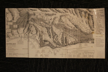 Lara RSL Sub Branch
Group of Maps World War One, Group of Maps World War One - Dardanelles and Anzac Gallipoli Maps Circ 1915, Circ 1916
Gallipoli 1915 Maps and Naval plan of Operations World War One ANZACRare examples that explain both ANZAC and Naval Operations during World War One Gallipoli & Dardanelles Passage .!. Black and White Photocopy of Gallipoli 1915 ANZAC Battlefield - detailed positions of troops and Cemeteries. 2.The Allied Failure to Force The Dardanelles Passage 18 March 1915 - detailed line of Attack Naval Organisation, Mine layout, Plan of Attack (and copy).. 3. Map of Turkey and surrounding area written in Turkish and German Languages. C0olor version main roads and distances. (and copy).. 4. Map of ANZAC Trench Diagram. World War One.Color. (and copy). 5.Panorama of Chunuk Blair from 3 miles south of Nibrunesi Point, 3 November 1915 and Anzac from 1 mile N. E. of Ari Burnu, 21 November 1915. Black & White 6. Color Map of ANZAC positions with topographical Details, notes. 1. Artwork and copyright by Srewart Cownie, Gallipoli 1915 ANZAC Battlefield with Landings and later evacuation marked. 2. Details of Naval actions taken in the Dardanelles Passage 18 March 1918. 3. Local area Map or Turkey. Shows roads network and townships. 4. ANZAC Trench Diagram, copyright Whitcombe & Tombs Limited , Wellington N.Z. 1919 5. Panorama of two coast views of ANZAC area. Australian War Memorial, 6. Map of ANZAC positions of World War One, Gallipoli 1915. Published by H.E.C. Roberinson, George Street, Sydney N.S.W.18 April 1916maps operational of anzac and naval opations during 1915 etc, dardanelles naval opations -
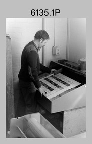
 Bendigo Military Museum
Photograph - AUTOMAP 1 Production – Army Survey Regiment, Fortuna, Bendigo, c1978-1980
This collection of 20 photos was most likely taken in c1978. The AUTOMAP 1 computer assisted cartography and mapping system was introduced in 1975. The components of AUTOMAP 1 were the Input Sub-System of four Wild B8s stereoplotters and three Gradicon digitising tables, the Optical Line Following Sub-System – Gerber OLF, the Verification Sub-System – Gerber 1442 drum plotter, the General Purpose Sub-system – HP21MX computer and the Output Sub-System – Gerber 1232 flatbed plotter). The first map was published in 1978 (Strickland 3665-3, 1:50,000). AUTOMAP 1 was the first computer assisted cartography and mapping system utilised by the Survey Corps and was the first system used by Australian mapping organisations. The history of the AUTOMAP 1 system is covered in more detail with additional historic photographs, in pages 116-118 of Valerie Lovejoy’s book 'Mapmakers of Fortuna – A history of the Army Survey Regiment’ ISBN: 0-646-42120-4. See items 6122.20P, 6410.24P, 6183.19P, 6200.5P, and 6222.17P for additional photographs of the AUTOMAP 1 system.This is a set of 20 photographs of Air Survey Squadron military and civilian personnel operating AUTOMAP 1 equipment at the Army Survey Regiment at Fortuna, Bendigo, c1978-1980. Black and white photos .1P to .18P are on photographic paper and were scanned at 300 dpi. Photo .4P is in colour and mounted with a duplicate on manilla card. Black and white photos .19P to .20P are on 35mm negative film and scanned at 96 dpi.They are part of the Army Survey Regiment’s Collection. .1) - Photo, black & white, c1978-1980, Gerber Optical Line Follower (OLF), SSGT John Bennett. .2) - Photo, black & white, c1978-1980, HP21MX computer General Purpose Sub-system. .3) - Photo, black & white, c1978-1980, Gerber OLF .4) - Photo, colour, c1978-1980, unidentified digitising on Gradicon edit table. .5) - Photo, black & white, c1978-1980, Gerber verification drum plotter. .6) - Photo, black & white, c1978-1980, Gerber OLF, CAPT Rob Bridge. .7) - Photo, black & white, c1978-1980, Programming and system administration, SGT Alan Toogood. .8) - Photo, black & white, c1978-1980, Unidentified digitising on Gradicon edit table. .9) - Photo, black & white, c1978-1980, CPL Rick Downie digitising on Gradicon edit table. .10) - Photo, black & white, c1978-1980, SPR Dave Irving digitising on Gradicon edit table. .11) - Photo, black & white, c1978-1980, Gerber OLF and CPL Rick Downie. .12) - Photo, black & white, c1978-1980, 1130 Computer System administration, L to R: unidentified, SSGT Les Dixon, SPR Geoff Havelberg. .13) - Photo, black & white, c1978-1980, AUTOMAP 1 tape administration, Maryanne De Groot. .14) - Photo, black & white, c1978-1980, AUTOMAP 1 tape drive. .15) - Photo, black & white, c1978-1980, HP21MX computer General Purpose Sub-system. .16) - Photo, black & white, c1978-1980, digitising topographic features with a Wild B8 stereo plotter, L to R: unidentified, CPL John Smith. .17) - Photo, black & white, c1978-1980, digitising topographic features with a Wild B8 stereo plotter, CPL John Smith. .18) - Photo, black & white, c1978-1980, digitising topographic features with a Wild B8 stereo plotter, CPL Adrian Rynberk. .19) - Photo, black & white, c1978-1980, Programming and system administration, SGT Alan Toogood. .20) - Photo, black & white, c1978-1980, Gerber OLF, CPL Chris Edwards. .1P to .20P - No personnel are identified.royal australian survey corps, rasvy, army survey regiment, army svy regt, fortuna, asr, automap 1 -
 Bendigo Military Museum
Photograph - Army Survey Regiment’s Officers, Warrant Officers and Sergeants and Squadrons, at Fortuna, Bendigo, 1982
This is a set of six staff photographs of the Army Survey Regiment’s Officers, Warrant Officers and Sergeants, and each of its four Squadrons at Fortuna, Bendigo in December 1982. Note - Air Survey Squadron’s photo was probably taken in July 1982 as they appear in winter dress. Air Survey Squadron was responsible for aerotriangulation, photogrammetric feature extraction and the AUTOMAP 1 system. Typical tasks were flight planning the acquisition of aerial photography, pugging, mensuration and block adjustments, photogrammetric extraction of topographic features from aerial photography, digital feature editing, map compilation, operating the scanner/plotter, operating the AUTOMAP 1 system and computer programming by civilians. Cartographic Squadron was responsible for the production of the following military products: Joint Operation Graphics, small-scale RAAF Air Charts, large-scale topographic line maps and orthophotomaps. Cartographic technician tasks were scribing, compiling, retouching, masking, type setting, type stickup, terrain embossing, correcting and proving quality control. Headquarters Squadron was responsible for the planning and coordination of map production and contracts. It also performed administrative and support functions such as personnel administration, pay, finance, transportation, records, map Library, kitchens, messes and facility maintenance. It was staffed by Army personnel from RASvy, RACT, AACC, RAAOC and RAEME corps. Other supporting staff at this time included the RAAF Liaison Officer, RAN Liaison Officer and several civilians employed in administration, the Q-Store and grounds maintenance. A component of the Army Svy Regt’s cartographic map production was carried out by the Detachment, a sub-unit located at Bonegilla next to the School of Military Survey. Lithographic Squadron was responsible for the reproduction of map materials and printing of military map products. The main tasks undertaken by photographic technicians were photographic enlargements, reductions and duplication of map reproduction material and processing of aerial photography. Printing technician tasks included platemaking, offset printing, map stock despatching and proofing.This is a set of six staff photographs of the Army Survey Regiment’s Officers, Warrant Officers and Sergeants, and its four Squadrons, at Fortuna, Bendigo, 1982. The black and white photographs were printed on photographic paper and are part of the Army Survey Regiment’s Collection. The photograph was scanned at 300 dpi. No personnel are identified. No personnel are identified. .1P – Annotated on front “OFFICERS MESS DEC ’82” .2P – Annotated on back “SGTS MESS DEC ’82” .4P– Annotated on front “CARTO SQN DEC ’82” .5P– Annotated on front “HQ SQN DEC ’82”royal australian survey corps, rasvy, army survey regiment, army svy regt, fortuna, asr, air survey, carto, litho -
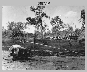 Bendigo Military Museum
Photograph - Bell 47G-2 helicopter used in Royal Australian Survey Corps Field Operations, c1965
This is a set of four photographs of Bell 47G-2 helicopters used in Royal Australian Survey Corps Field Operations. c1965. From 1957, helicopter transport of survey parties revolutionised transport in remote areas. The most common helicopter used by the Royal Australian Survey Corps at this time was the civilian Bell 47G-2 and the Sioux, the Australian Army’s’s equivalent. equivalent. From 1964 an Aerodist MRC2 airborne Electronic Distance Measuring (EDM) system was extensively used for topographic surveys over long distances by trilateration to replace traverse requiring survey station intervisibility. In 1965 the command field survey unit personnel attached to the Army Survey Regiment’s Topographic Squadron were used mainly in support roles such as station clearing, tower operations, station monumenting, Aerodist computations, forward base operations, geodetic observations on the north-south traverse and logistic support for Remote teams. .1P is a photo of a civilian Bell 47G-2 helicopter Registration / Serial VH-UTB owned by Helicopter Utilities from Mascot, NSW c1965. In the background of this photograph is three personnel and vehicles at a field survey camp. The left-hand vehicle is a Willys Jeep with trailer and on the right is probably a Truck, 2 1/2 ton, 6x6, General Service GMC. The Bell 47G-2: VH-UTB was destroyed, and its pilot killed in tragic circumstances during a civilian survey operation on Cape York Peninsula in June 1966. .2P is a photo of a a civilian Bell 47G-2 helicopter Registration / Serial VH-IHB taken in Wyndham, WA. As the letters ‘TAA’ appear on the fuselage, the helicopter was charted from Trans Australian Airways. .3P is a photo of a Bell 47G-2: VH-UTC with survey camp in background. .4P is a photo of a Bell 47G-2 equipped with floats and unidentified personnel loading stores, possibly in Darwin. Acknowledgement: Royal Australian Survey Corps – Aerodist Years 1964-1975 Version 2021.0 Authored by Peter Jensen.This is a set of four photographs of civilian Bell 47G-2 helicopters used in Royal Australian Survey Corps Field Operations. c1965. The photographs were printed on photographic paper and are part of the Army Survey Regiment’s Collection. The photographs were scanned at 300 dpi. .1) - Photo, black & white, c1965, Bell 47G-2 helicopter: VH-UTB with survey camp in background. .2) - Photo, black & white, c1965, Bell 47G-2 helicopter: VH-IHB with survey station in foreground. .3) - Photo, black & white, c1965, Bell 47G-2 helicopter: VH-UTC with survey camp in background. .4) - Photo, black & white, c1965, Bell 47G-2 helicopter: Unidentified personnel loading stores possibly in Darwin..2P – annotated on bottom of photo ‘Wyndham Area – Helicopter drops observing party’ The other photographs are not annotated.royal australian survey corps, rasvy, army survey regiment, army svy regt, fortuna, asr, surveying -
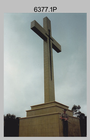 Bendigo Military Museum
Photograph - Army Survey Regiment Mount Macedon Memorial Cross Ceremony, 1995
This set of six colour photographs of a Catafalque Party from the Army Survey Regiment was taken at the Mount Macedon Memorial Cross on the 19th of November 1995. The ceremony was held to commemorate the 60th anniversary and the refurbishment of the site. The refurbishment entailed the complete replacement of the cross and its surrounds. The cross is also known as the Cameron Memorial Cross and was built in 1935 as a memorial for those who lost their lives in the First World War. The Guest Speaker was Mr Bruce Ruxton AM MBE OBE, who at the time was the president of the Victorian RSL. He served in the 2/1st Australian Topographical Survey Company in WW2 before reallocation to the 2/25th Australian Infantry Battalion. He was the president of the Victorian RSL from 1979 to 2002 and was a staunch vocal advocate for the health and welfare of war veterans and their families. Refer to the Wikepedia web site for more detail on the history of the Mount Macedon Memorial Cross and Mr Bruce Ruxton AM MBE OBE.This set of six colour photographs of a Catafalque Party from the Army Survey Regiment was taken at the Mount Macedon Memorial Cross on the 19th of November 1995. The photographs were printed on photographic paper and are part of the Army Survey Regiment’s Collection. The photographs were scanned at 300 dpi. .1) - Photo, colour, 1995. Mount Macedon Memorial Cross Ceremony, SPR James Commons in foreground. .2) - Photo, colour, 1995. Mount Macedon Memorial Cross Ceremony, Guest Speaker - Mr Bruce Ruxton AM MBE OBE. .3) - Photo, colour, 1995. Mount Macedon Memorial Cross Ceremony, SPR Katie Royce, unidentified soldier in background. .4) - Photo, colour, 1995. Mount Macedon Memorial Cross Ceremony, James Commons. .5) - Photo, colour, 1995. Mount Macedon Memorial Cross Ceremony, L to R: SSGT Peter Coles, SPR James Commons. .6) - Photo, colour, 1995. Mount Macedon Memorial Cross Ceremony, SPR James Commons. Each photo is annotated ‘Mt Macedon Memorial Cross Ceremony 19 Nov 95. Mr Bruce Ruxton AM MBE, OBE, SSGT Peter Coles, SPR Katie Royce and SPR James Commons are identified on the photos. royal australian survey corps, rasvy, army survey regiment, army svy regt, fortuna, asr -
 Bendigo Military Museum
Photograph - Stereoscopic Equipment – Army Survey Regiment, Fortuna, Bendigo
This is a set of six photographs of stereoscopic equipment and personnel at the Army Survey Regiment, Fortuna, Bendigo, c1950s to c1960s. The stereoscopes shown in photos .1P and .2P were used to stereoscopically view and interpret features in overlapping aerial photographs. The stereoscopic plotters shown in photos .3P and .4P were used to stereoscopically plot topographic detail from overlapping aerial photographs using a pantograph arm with pencil onto a controlled plotting sheet. The Ryker Model PL-3 Wernstedt-Mahan type stereoscopic plotter shown in photos .5P and .6P was used for precision contouring, planimetry and profiling. It was a comparatively simple stereoscopic mapping instrument designed to use ordinary contact prints of aerial photographs. It provides for plotting on a constant scale and approximate tilt correction but does not provide refinements such as correction for lens distortion. The plotter in Photo .6P does not have its pantograph arm attached. These plotters pre-date the Wild B9 and B8 stereo plotters introduced in the 1960s.This is a set of six photographs of stereoscopic equipment and personnel at the Army Survey Regiment, Fortuna, Bendigo, c1950s to c1960s. Black and white photos are on photographic paper and were scanned at 300 dpi. .1) - Photo, black & white, c1950s to c1960s, Universal Stereoscope, unidentified technician. .2) - Photo, black & white, c1950s to c1960s, Old Delft Scanning Stereoscopes, unidentified technicians. .3) - Photo, black & white, c1950s to c1960s, Unidentified stereoscopic plotters and technicians. .4) - Photo, black & white, c1950s to c1960s, Unidentified stereoscopic plotter, CPL Bill Shapcott. .5) and .6) - Photo, black & white, c1950s to c1960s, Ryker Model PL-3 stereoscopic plotter.Photo .4P is annotated on back - ‘Bill Shapcott (CPL)’royal australian survey corps, army svy regt, rasvy, army survey regiment, fortuna, asr, air survey, photogrammetry -
 Bendigo Military Museum
Photograph - Print Troop – Lithographic Squadron – Army Survey Regiment, Fortuna, Bendigo
This collection of 23 photos was most likely taken in Lithographic Squadron, Army Survey Regiment, Fortuna, Bendigo, in 1988. In photos .1P and .2P the technician is preparing a Chromalin map proof for supporting information that would be printed on the reverse side of a topographic map. This map was commonly referred to as a ‘snack’ map, with photos of edible indigenous plants and descriptions endemic to that region printed on the reverse side to assist soldiers living off the land in survival situations. The authoritative information was provided by Major Leslie James (Les) Hiddins aka ‘the Bush Tucker Man’ He is a retired Australian Army soldier and war veteran, who is best known for his love and knowledge of the Australian bush. See item 6190.6P for more information on the Chomalin proof production process. In the remaining photos, Print Troop’s technicians were most likely operating the Komoni, Planeta or Ultra-MAN-III offset printing presses, as well as working in the map despatch dock. Although these photos are not annotated most personnel are positively identified. This is a set of 23 photographs of Print Troop personnel and equipment from Lithographic Squadron at the Army Survey Regiment, Fortuna, Bendigo, 1988. The photographs were on 35mm negative film and were scanned at 96 dpi. They are part of the Army Survey Regiment’s Collection. .1) - Photo, black & white, 1988, Chromalin Proof laminating, Terry King. .2) - Photo, black & white, 1988, Chromalin Proof laminating, Terry King. .3) to .6) - Photo, black & white, 1988, Ultra-MAN-III Printing Press, Colin Yeats. .7) - Photo, black & white, 1988, Ultra-MAN-III Printing Press, L to R: Greg Rowe, SPR Mark ‘Dogs’ Doherty. .8) - Photo, black & white, 1988, Ultra-MAN-III Printing Press, SPR Mark ‘Dogs’ Doherty. .9) to .10) - Photo, black & white, 1988, Ultra-MAN-III Printing Press, John Bateman. .11) - Photo, black & white, 1988, Ultra-MAN-III Printing Press. .12) - Photo, black & white, 1988, Map laminator? L to R: SGT Dale Hudson, SGT Gary Kerr. .13) - Photo, black & white, 1988, Newkoni Komori Printing Press, Peter Hamilton. .14) to .17) - Photo, black & white, 1988, Original Heidelberg Printing Press, Peter Hamilton. .18) to .19) - Photo, black & white, 1988, Map Despatch area, SPR Steve Wright. .20) - Photo, black & white, 1988, Map Despatch area, L to R: unidentified, SGT Gary Kerr. .21) - Photo, black & white, 1988, Printing Presses - foreground: Ultra-MAN-III (x2), centre: Newkoni Komori and background: Planeta Polygraph. .22) - Photo, black & white, 1988, Ultra-MAN-III Printing Presses (x2). .23) - Photo, black & white, 1988, L to R: Daryl South, Mark McCulloch.No personnel are identifiedroyal australian survey corps, rasvy, army survey regiment, army svy regt, fortuna, asr, litho, printing -
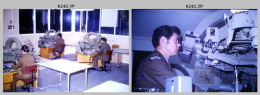
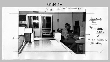
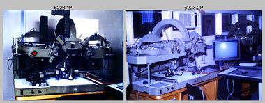 Bendigo Military Museum
Photograph - AUTOMAP 2 Production - Army Survey Regiment, Fortuna, Bendigo, c1986
This collection of 23 photos of map production on the AUTOMAP 2 computer-based system in Air Survey and Cartographic Squadrons, was most likely taken in 1986. The AUTOMAP 2 system was an upgrade to the AUTOMAP 1 system, comprising Intergraph graphic edit workstation terminals networked to VAX 750/785 main frame computers. Unlike AUTOMAP 1, operators could display digital topographic features on monitors for editing. Successful adaptation of this system meant RASvy was at the forefront of digital mapping/cartographic systems in Australia and overseas. The system comprised Input (Wild B8 Aviograph feature extraction) Raster Scanning (digitising from compilation sheets, Graphic Edit (cartographic completion) and Plot Verification Sub Systems. The system was operational from 1984 to its ‘Newheart’ upgrade in 1993. Throughout its life, the system was progressively refined with productivity gains, achieved from award winning technical development in-house by talented and innovative Army Survey Regiment personnel.This is a set of 23 photograph of AUTOMAP 2 production at the Army Survey Regiment at Fortuna, Bendigo, c1986. The photographs were on 35mm colour slides and were scanned at 96 dpi. Photos .5P and .6P are also printed on photographic and scanned at 300 dpi. They are part of the Army Survey Regiment’s Collection. .1) - Photo, colour, c1986, AUTOMAP 2 Production - Army Survey Regiment, Fortuna, Bendigo. c1986. .2) - Photo, colour, c1986, AUTOMAP 2 Wild B8 Aviograph stereoplotter. .3) - Photo, colour, c1986, AUTOMAP 2 Wild B8 Aviograph stereoplotter feature extraction, unidentified technician. .4) - Photo, colour, c1986, Wild B8 Aviograph stereoplotter feature extraction, LCPL Raelene (Munting) Brodie. .5) - Photo, colour, c1986, AUTOMAP 2 computer tape maintenance, SPR Steve Linane. .6) - Photo, colour, c1986, AUTOMAP 2 Graphic Edit Workstation, SPR Steve Linane. .7) to .8) - Photo, colour, c1986, AUTOMAP 2 Graphic Edit Workstation, unidentified technician. .9 to .10) - Photo, colour, c1986, AUTOMAP 2 Graphic Edit Workstation. .11) - Photo, colour, c1986, AUTOMAP 2 Graphic Edit Workstation feature coding and command menu. .12) - Photo, colour, c1986, AUTOMAP 2 high resolution computer monitor. .13) to .16) - Photo, colour, c1986, AUTOMAP 2 production output comparison to AUTOMAP 1. .17) to .18) - Photo, colour, c1986, AUTOMAP 2 computer system components. .19) - Photo, colour, c1986, AUTOMAP 2 Intergraph 7596 verification plotter. .20) - Photo, colour, c1986, AUTOMAP 2 Benson verification plotter, SPR Steve Coulson. .21) - Photo, colour, c1986, AUTOMAP 2 drainage, contour, roads and cultural digital data verification plot. .22) - Photo, colour, c1986, AUTOMAP 2 drainage, contour, roads and cultural digital data on computer monitor. .23) - Photo, colour, c1986, AUTOMAP 2 3D digital terrain model on computer monitor. .1P to .23P - Some of the equipment is annotated on the frame of the 35mm slides. .5P & .6P prints annotated incorrectly ‘Steve Lenane’. Correct spelling is - ‘Steve Linane’ royal australian survey corps, rasvy, army survey regiment, army svy regt, fortuna, asr, automap 2 -
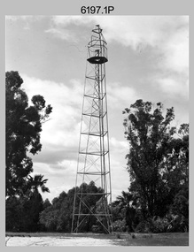 Bendigo Military Museum
Photograph - Royal Australian Survey Corps Survey Observation Towers, c1950s
This is a set of seven photographs of Royal Australian Survey Corps surveyors setting up observation towers in the field and undertaking survey observations during mapping and geodetic control operations. c1950s. Survey observation towers were used mainly to take angular measurements in flat or heavily forested terrain, where height was necessary to achieve observer’s line-of-sight between field survey station. The Bilby Tower seen in photo .5P was erected to a height of 75 feet (23m) above ground level. The use of the Bilby Tower in Topographic Squadron’s field survey operations from 1955 to 1966 is described in page 54 of Valerie Lovejoy’s book 'Mapmakers of Fortuna – A history of the Army Survey Regiment’ ISBN: 0-646-42120-4. CAPT George Ricketts’ period of service was from 1942 to 1976 reaching the rank of LTCOL. It is noted in page 35 of Valerie Lovejoy’s book that then SGT Ricketts hand lettering skills came to the fore from his contribution to the draughting of one of the Japan’s Instruments of Surrender in 1945.This is a set of seven photographs of Royal Australian Survey Corps surveyors setting up observation towers in the field and undertaking survey observations during mapping and geodetic control operations. c1950s. The photographs were printed on photographic paper and are part of the Army Survey Regiment’s Collection. The photographs were scanned at 300 dpi. .1) - Photo, black & white, c1950s, ‘Bilby’ survey observation tower. .2) - Photo, black & white, c1950s, CAPT George Ricketts climbing ‘Bilby’ survey observation tower. .3) - Photo, black & white, c1950s, geodetic survey equipment on ‘Bilby’ survey observation tower. .4) - Photo, black & white, c1950s, two unidentified field surveyors on ‘Bilby’ survey observation tower. .5) - Photo, black & white, c1950s, two unidentified field surveyors, with CAPT Ricketts climbing ‘Bilby’ survey observation tower. .6) - Photo, black & white, c1950s, two unidentified field surveyors undertaking observations on survey observation tower. .7) - Photo, black & white, c1950, two unidentified field surveyors erecting or dismantling a survey observation tower..1P with paper tag annotated ‘Bilby Tower’ .4P on back – ‘Bilby Tower’. .5P on back – ‘Survey Observing Tower. Observing tower used for angular measurement in flat country. 75’ high – CAPT Ricketts climbing. .6P, .7P on back. ‘1960s?’royal australian survey corps, rasvy, army survey regiment, army svy regt, fortuna, asr, surveying