Showing 200 items
matching track plans
-
 Ballarat Tramway Museum
Document - Photocopies, Photocopies of layout plans of South Melbourne tram depot
Five A3 photocopies of drawings of the South Melbourne tram depot and per way yard. Drawings dated 8/1938. Depot also known as Hanna St. Depot. Sheet A - drawing of per way yard section , drawing P8349. Sheet B - drawing of whole depot and tracks in Hanna St. - drawing P8345. - date 12/8/1938. Sheet C - drawing of entry area and detail plans of administrative blocks - drawing P8346. Sheet D - drawing of south end of yard at corner of Hanna and Bank Streets - overhead and building section - drawing P 8348. Sheet E - drawing of tramcar depot portion of the site, with rolling stock offices and building to the south side of the car shed - drawing P8347, dated 12/8/1938.trams, tramways, south melbourne depot, hanna st. depot, mmtb, depot -
Ballarat Tramway Museum
Newspaper, Mariza Fiamengo, "Tram plans continue on track", 2/05/2001 12:00:00 AM
... "Tram plans continue on track"... and Dianne Smith. "Tram plans continue on track" Newspaper Mariza ...Newspaper cutting from The Courier, Ballarat, 2 May 2001, written by Mariza Fiamengo advising that the Federal Government had made a $73,000 grant for a feasibility study of linking Ballarat's major tourist attractions through a tram system. Gives some background and quotes from Michael Ronaldson, Peter Winspur, Eugene Kneebone and Dianne Smith."The Courier, Ballarat, Wednesday 2 May 2001" in a box on the left hand side of the cutting.tram reinstatement, federal grant, feasibility study, city tramway -
 Ballarat Tramway Museum
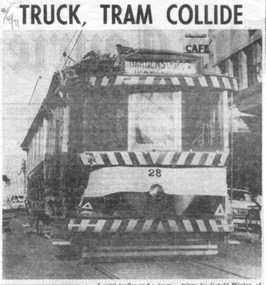
Newspaper, Herald & Weekly Times Ltd, "Truck, tram collide", "Group charters tram", "Ballarat plans tram museum", 1971
Set of three newspaper clippings pasted onto a single sheet of paper with two Punch holes on the left hand side. First clipping from The Courier, Ballarat, 2/4/1971 with photo of tram 28 after is collision the previous day with a semi-trailer at the intersection of Princes and Victoria Streets. Gives names of the vehicle drivers and cost of the damage. Photo is of the tram returning to the depot under its own power. Tram passenger named as Margaret Foley, tram driven by James Mason and the truck driven by Gerald Winter of Gordon. See Reg Item 672.1 for a print of the Courier Photograph. Second is from The Courier, Ballarat, 15/4/1971 of the Brown Hill Progress Association chartering a tram to create interest in the project for the retention of Ballarat's trams. The tram was to leave Drummond and Sturt St. intersection the following Sunday at 1245. Item mentions the election of an interim executive and expression of interest of people outside the city. Third is from The Sun, Melbourne, 31/5/1971 about Ballarat 'tram-lovers' deciding to have a working tramway museum. Quotes Mr. Paul Nicholson, a member of the Ballarat Tramway Preservation Society. Notes that Museum will have eight trams using two miles of existing track around Lake Wendouree. Also notes that the SEC had received 88 applications for the 44 trams in both Ballarat and Bendigo.Image of the 3rd item added 28/3/2011 - see i1 and for the actual cutting i4. Original of newspaper of item 1 - also has items about the future of the railway workshops following a cost review and a story of page 1 of a submission to the Victorian Land Transport enquiry.In red ink on first cutting in top left hand corner "2/4/71" and in blue ink in top right hand corner on second cutting "15/4/71".trams, tramways, accidents, closure, charters, museum establishment -
 Ballarat Tramway Museum
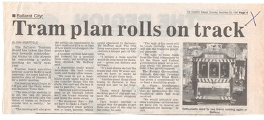
Newspaper, The Courier Ballarat, "Tram Plan rolls on track", 28/12/1995 12:00:00 AM
... "Tram Plan rolls on track"..., with destination of Sebastopol. "Tram Plan rolls on track" Newspaper ...Article from page 9 of The Courier, Thursday 28/12/1995 written by Ian Haberfield that a tentative date had been set for Jan. 23, 1996 for a public meeting to discuss the return of trams to Ballarat. Quotes Tourism Board Executive Director Andrew McEvoy. Includes a picture of tram 40, with destination of Sebastopol."X" in blue ink in top right hand cornertrams, tramways, public meeting, ballarat city tramway, ballarat revival -
 Ballarat Tramway Museum
Memorabilia - Scrap Book, Neville Gower, Nov. 1992 to June 1997
Scrap Book - with printed cardboard covers - titled scrap book on outside and reproductions of newspaper clippings printed onto covers, 64 pages off white paper. Scrap book compiled by Neville Gower from Nov. 1992 to June 1997. Primarily consists of newspaper clippings glued to the pages involving the Ballarat Tramway Museum. Also contained are other items of relevant interest, such as BTM brochures. Pages number in pencil by Warren Doubleday 2/2001. Where relevant some items contained in this book have been separately catalogued to enable easier reference. Some items were already in the collection and are thereby reference with their registered number. Also contains registered items 1659, 1654 and 1655. Page Description of item 1 Newspaper clipping - 9/11/1992 - Reg. item No. 1105 Newspaper cutting - "New Life for old tram" - Courier 6/11/1992, p7 forthcoming recommissioning of Horse tram No. 1 at depot on Saturday. Gives details of horse tram and some notes on horse trams. 2 Newspaper cutting -"Where is this tram now", BTPS seeking information on the whereabouts of a former ESCo tram, photo taken in Sept. 1971 - See Reg. No. 1651 - Courier Heritage column 19/1/1993 Newspaper cutting "Collector enjoys his postcards of the past", Courier Heritage column 26/1/1992, about Andrews Kabia's collection of postcards. Has a photo of Bridge St. with a tram, c1950's. 3 Reg Item No. 1659 - Newspaper cutting - "SEC offers historic lake property for sale" 20/2/1993. Postcard - Sovereign Hill reproduction - purchased 2/1993, of Bridge St., looking west. Postcard - Sovereign Hill reproduction - purchased 2/1993, of Bridge St looking east - See Item No. 841 and image i4. Newspaper clipping of BTPS advertisement for 1993 Begonia Festival - Courier 3/3/1993. 4 Newspaper clipping "BUCpower on track" Courier 15/5/1993 - Ballarat University College tram pulling challenge to other schools. Has photo of BUC team lined up in front of No. 26. Ballarat Vintage tram brochures - 2 No. - Reg. Item 294.1 5 Lake Wendouree Caravan Park brochure - c1993 - colour photo of No. 26 at St. Aidans Drive. Registered item No. 1654 Newspaper clipping - "Horse drawn transport heritage" (11/5/1993) 6 Newspaper clipping - Courier 28/6/1993 - "New tramways video shows early Ballarat" - launch of BTM/BTPS video, sales details, quotes R.Gilbert. Has head on photo of No. 40 in Sturt St. showing Sebastopol. Postcard of four scenes of Ballarat, Steve Parish production, featuring BTM No. 27 in Wendouree Parade. Postcard - BTM issue - July 1993 - of three trams - see Reg. Item No. 1657. Separate copy of the cutting re video added 29-3-2016 from donation of Lil Butler - see image i3. 7 Postcard - Ballarat Victoria featuring 9 views of Ballarat, first one is of 27 in SEC late 1960's colour scheme in Wendouree Parade, operated by BTPS. - purchased July 1993. Postcard - Ballarat Vic Aust. - featuring four view of Ballarat, fourth one is of BTM 14 at crossing loop - purchased July 1993. Newspaper clipping - Courier 2/8/1993 "Tram Plan too costly" - quoting Dave Macartney about the costs of bringing trams Ballarat to Ballarat - took costly. Also quotes Ballarat Tourist Assoc. Secretary - Brian Whykes and Peter Hiscock of Sovereign Hill. 8 Newspaper clipping - Courier 28/7/1993 - "Major changes planned for lake" (page 1) and "Lake area changes proposed - Plan to narrow Wendouree Parade" - controlling traffic speed in parade. Newspaper clipping - Courier 21/9/1993 - "Council adopts strategy for lake traffic" - control of traffic in Wendouree Parade. 9 Newspaper clipping - Courier 3/8/1993 - "Lake changes will turn tourists away" - letter from R.A. Nelson about Wendouree Parade traffic control. Newspaper clipping - Courier 3/8/1993 - Council plan for Wendouree Parade - not one way traffic. Newspaper clipping - Courier 31/7/1993 - "Lake traffic strategy raises questions" - letter from L. Holloway. Newspaper clipping - Courier 8/8/1993 - "Strategy will improve access" - letter from Cr. Janet Dale. Newspaper clipping - Courier 15/9/1993 -"City defers action on Lake changes" - traffic plans deferred. 10 Newspaper clipping - Courier 31/8/1993 - "Plans threaten Lake amenities" letter from L. Holloway. Copy of letter from Warren Doubleday, Engineering Manager of BTPS to Andrew O'Brien and Associates re traffic study - dated 26/4/1993. 11 page 2 of above letter. 12 Letter from Jim W. Bell of the Golden City Paddle Steamer Museum Society to Neville Gower forwarding a copy of a submission to the Rotary Club of Ballarat South, in which they mentioned a extension of the tramline around Lake Wendouree. Newspaper clipping - Courier 30/9/1993 - "City's plans to narrow lake road dropped". 13 Poster from the Ballarat Tourist Association - for "Days of Discovery" 14-15 August 1993. Lists "Ballarat Historic Tramways" as one of the attractions. Loose item - Invitation from the "Golden City Paddle Steamer Society" to join as a member. 14 Newspaper clipping - Courier - 9/9/1993 - about the BTPS calling for nominations and forthcoming AGM Newspaper clipping - Courier - 18/9/1993 - about the BTPS launching a new book - "Ballarat's Heritage Tramway" - Stephen Butler holding a copy, with No. 12 in the background. Story by Lorrie Brown. (Image of this cutting added 28/3/2011) 15 Newspaper clipping - Courier 23/9/1993 - Reg. Item No. 1108 and 1109. Newspaper clipping - Courier - undated - c late 1993 - of SES challenging other people to a tram pulling competition in forthcoming Begonia Festival. Has photo of group pulling horse tram No. 1 with Frank Puls looking on. 27 in the background. Story by Dennis Torpy. 16 & 17 -copy of brochure (see Item 1108 for launch details) about Lake Wendouree, its history, ecology, wildlife and other attractions, including a drawing of the lake and locations. Printing sponsored by McDonalds. Produced by City of Ballaarat. 18 Newspaper clipping - Courier 30/10/1993 - review of book titled "Watch for Trams", published by Kangaroo Press . Has a photo of a Melbourne cable car set in Sydney Road Brunswick with bogie trailer. 19 Newspaper clippings - In Retrospect section of The Courier 30/7/1994 - 100 years ago - first shipment of electric light equipment for Ballarat in three weeks 30/7/1994 - 25 years ago - Retirement of Dan Irvin as tram depot foreman 17/9/1994 - 25 years ago - Council asking for abandonment of Ballarat trams 3/12/1994 - 25 years ago - hiring of trams by Jewish Youth group for convention 8/7/1995 - 100 years ago - construction of line along the south side of Sturt St between Ripon and Pleasant - related to horse tramways. 15/7/1995 - 100 years ago - Courier reporting completion of above tram line. 18/10/1994 - 40 years ago - retirement of H. W. Preston, former driver and first person to drive an electric tram over the line from Rubicon St. to Sebastopol. Newspaper clipping - Courier 31/12/1993 - School holidays supplement - and free travel voucher for Ballarat Tramways. 20 Newspaper clipping - Courier 4/1/1994 - Reg. item 1655 - "David Kellett's life on the trams" Newspaper clippings - In Retrospect section of The Courier 25/6/1994 - 50 years ago - raising of funds for patriotic appeal by Sylvia Mitchell - conductress 2/7/1994 - 50 years ago - Mayor the City of Maryborough complaining about Treasure Tram in Maryborough and raising funds for patriotic appeal. 21 Newspaper clipping - Courier 4/8/1994 about Transport Minister Alan Brown offering Ballarat surplus trams at a Ballarat Chamber of Commerce AGM. Newspaper clipping - Courier 6.8.1994 - Seaton Ashton in a column about the tram offer of Alan Brown and suggesting a line around the Lake. Newspaper clipping - Courier 6/9/1994 - Reg. Item 1132 Newspaper clipping - Courier 20/9/1994 - Reg Item 1117. 22 Newspaper clipping - Courier 5/10/1994 - Reg Item 1121 23 BTPS pamphlet (brochure) for tramway - see Reg. Item 300.1 24 Newspaper Clipping - Courier 16/3/1995 - advertising feature - Golden City Paddle Steam restored to service on Lake Wendouree and associated Gill Boat shed. Two separate items. 25 Newspaper Clipping - Courier 3/1/1995 - "Rosella searches for memorabilia" - heritage column - Lorrie Brown - has postcard photo of an ESCo tram turning from Sturt St into Lydiard St. North, taken from Post Office. Newspaper clipping - In Retrospect section of The Courier - 7/2/1995 - "Trams revived" - about opening of BTPS tramway, 20 years ago. 26 Newspaper clipping - Courier - 28/6/1995 - Inside/Out column written by Kim Quinlan - Interview with Peter Hiscock. Mentions that he is passionate about the restoration of tramways to Ballarat. 27 - Newspaper clipping - Courier - 3/6/1995 - item about Sunday Trading in Ballarat - Peters Hiscock saying entertainment needed and possibility of tramways in Ballarat. Quotes Warren Doubleday in item. Has photo of Peter Hiscock on steps of No. 27 - Photo by Ian Wilson. Part of front cover of "This month in Ballarat", July 1995, which has a photo of BTM No. 27. 28 Cutting from July 1995 Royalauto magazine - featuring a picture report by Ron Warren on the AETM museum at St Kilda. 29 Newspaper clipping - Courier - 27/7/1995 - about plan to improve Botanical Gardens, extension of tram tracks to Sturt St. Editorial Opinion column 28/7/1995 about the Botanical Gardens and extension of tramway. 30 Newspaper clipping - Courier - 18/8/1995 - "Public Views invited on Strategy Plan" - item by Angela Barlow, about CBD development in Ballarat. Mentions reinstatement of trams in Ballarat. Letter to Editor - 21/8/1995 - "Who asked for Lake Changes" - A. Simpson of Ballarat - questioning possible changes to the Botanical Gardens. 31 Newspaper clipping - Courier - 9/8/1995 - "City Plans to spend $67m in three years - pages 1 and 2 of Courier - notes reinstatement of "tramway communications" 32 - Brochure by City of Ballarat Central Business Area of the Strategy Plan for area - includes possible developments, - notes reinstatement of trams to provide a linkage mechanism between Bridge St and Central Square shopping area - dated August 1995. Newspaper clipping - Courier - 22/11/1995 - item by Ian Haberfield about the endorsement of the strategy plan for the CBD or CBA strategy plan. 33 Newspaper clipping - Courier - 24/11/1995 - letter to the Editor - about CBA strategy plans - by C. McDonald and noting a tramway to Sovereign Hill. Newspaper clipping - Courier - 4/10/1995 - Reg. item 1104. Newspaper clipping - Courier - 29/11/1995 - "Discussion on final gardens plan tonight" - Ian Haberfield - Gardens Masterplan - draft - notes tramway extensions Newspaper clipping - Courier - 30/11/1995 - "First look at Masterplan" for gardens, item by Andrew Lang. 34 Newspaper clipping - Courier - 19/9/1995 - School Holiday fun supplement advert page - includes an advertisement by the BTM noting operation of Horse tram on 1/10/1995. 35 Newspaper clipping - Courier - 12/12/1995 - Reg item 1450.1 Newspaper clipping - Courier - 11/12/1995 - Reg item 1449 Newspaper clipping - Courier - 1/11/1995 - "New face for City" item by Ian Haberfield - Ballarat Central area plan - quotes Chief Commissioner Vern Robson. 36 Newspaper clipping - Courier - 5/12/1995 - Reg item 1444 37 Newspaper clipping - Courier - 8/11/1995 - Reg item 1446 Newspaper clipping - Courier - 9/12/1995 - Reg item 1447.2 37A Newspaper clipping - Courier - 16/12/1995 - Reg Item 1452.1 and .2 Newspaper clipping - Courier - 23/12/1995 - Reg Item 1448 Newspaper clipping - Courier - 16/12/1995 - Reg Item 1453 Newspaper clipping - Courier - 21/12/1995 - "Railway shops would hurt CBD - letter to Editor from David Peile, about the proposal for a shopping centre at the railway station. 37B Newspaper clipping - Courier - 16/12/1995 - column by the Commissioner - Vern Robson, including a note about the BTM and its members and the work it does. Newspaper clipping - Courier - 28/12/1995 - Reg Item 1455 38 Newspaper clipping - Courier - 22/1/1996 - Reg Item 1456 Newspaper clipping - Courier - 27/1/1996 - Reg Item 1463 Newspaper clipping - Courier - 25 Years ago - suggesting retention of tram line by Brown Hill Progress Association around Lake Wendouree - no date. 39 Newspaper clipping - Courier - 27/1/1996 - Reg Item 1464 Newspaper clipping - Courier - 24/1/1996 - Reg Item 1457 40 Newspaper clipping - Courier - 19/2/1996 - Reg Item 1472 Newspaper clipping - Courier - 31/1/1995 - Reg Item 1468 Newspaper clipping - Courier - 30/1/1996 - Reg Item 1467 Newspaper clipping - Courier - 3/1996 - 50 years ago - Retirement of SEC office manager Mr. W. K. J. Dunstan. Newspaper clipping - Courier - 4/5/1996 - 25 years ago - replacement of trams mooted - announcement by Transport Regulation Board. 41 Newspaper clipping - Courier - 24/2/1996 - Reg Item 1473 Newspaper clipping - Courier - 6/4/1996 - 25 years ago - Brown Hill Progress Association seeking support for retention of trams around Lake Wendouree. Newspaper clipping - Courier - 18/5/1996 - 50 years ago - announcement that tram services would be curtailed as from next Monday due to power restrictions. 42 Newspaper clipping - Courier - 5/4/1996 - "Tram Study Close" - Ken Hill reporting that Peter Hiscock saying that study for tramway should get a go ahead within the next three months. Newspaper clipping - Courier - 26/2/1996 - Reg Item 1475. 43 Fax of newspaper clipping 18/5/1996 - of Reg Item 1493 - item fading. 44 Newspaper clipping - Courier - 8/3/1996 - Reg Item 1126 and 1494.1 Envelope, letter and newsletter from Labor Senator Barney Cooney regarding the 1996 Federal Election. Envelope has a photo reproduction of tram 14. 45 Newspaper clipping - Courier - 24/4/1996 - Reg Item 1496 Newspaper clipping - Courier - 17/9/1996 - "Tram submission lodged" - lodging grant application with Tourism Victoria for support for study. Newspaper clipping - Courier - 27/57/1996 - 25 years ago - about the hijacking of the tram in Barkly St. shortly before closure. Newspaper clipping - Courier - 9/11/1996 - 50 years ago - construction of a shelter at corner of Sturt and Drummond St. for tram passengers. Newspaper clipping - Courier - 22/11/2996 - editorial opinion - regarding roofing of mall and possibility of the return of trams. 46 Newspaper Clipping - Courier - 2/10/1996 - Reg Item 826 Newspaper Clipping - Courier - 11/12/1996 - "Live wires scare after bus hits pole" - item by Elise Sullivan, about a bus backing into a tramway pole in Wendouree Parade and breaking it. 47 Newspaper Clipping - Courier - letter from P.Kervarec - undated - c12/1996 - about Eureka Stockade area and removal of tram tracks. Newspaper Clipping - Courier - 16/11/1996 - Reg Item 1499 Newspaper Clipping - Courier - 24/1/1997 - Reg Item 1459 Newspaper Clipping - Courier - 21/9/1996 - 25 years ago - about Council decision for BTPS tram depot. 48 Newspaper Clipping - Courier - 16/1/1997 - Reg Item 1506 Newspaper Clipping - Courier - 10/1/1997 - "Hiscock wants hard facts to back tram sentiment" - discussing results of a survey of Ballarat residents and future studies. Newspaper Clipping - Courier - 11/1/1997 - Eureka Column - about trams coming back and a boon for car panel beaters. Newspaper Clipping - Courier - 11/1/1997 - 50 years ago - Council meeting and granting of fare concessions to children on trams and buses. Newspaper Clipping - Courier - 11/1/1997 -letter - "Keeping rail gates a matter of desire" 49 Newspaper Clipping - Courier - 10/1/1997 - Editorial - "A great idea but can we afford trams" - about the various studies and care should be taken. Newspaper Clipping - Courier - 10/1/1997 - cartoon - "Easy tram funding" - by Burns. Newspaper Clipping - Courier - 9/1/1997 - Reg item 1503 50 Newspaper Clipping - Courier - 7/1/1997 - Reg Item 1502 Newspaper Clipping - Courier - 13/1/1997 - Reg item 1504 51 Newspaper Clipping - Courier - 4/1/1997 - Reg item 1501 Newspaper Clipping - Courier - 14/1/1997 - Reg Item 1505 52 Horse Tram No. 1 pamphlet - Reg Item 1656 53 Newspaper Clipping - Courier - 3/2/1997 - "Sovereign Hill plans to re-invent itself" - report by Seaton Ashton on Sovereign's Hill's future planning. Newspaper clipping - Courier - 30/1/1997 - Reg item 1509 Newspaper clipping - Courier - letter from M. Buret of Wendouree suggest that Cobb and Co coaches be run in Ballarat. 54 - Newspaper Clipping - Courier - 5/2/1997 - "City decides in close vote to keep rail gates" - article on Lydiard St. North Railway Gates - article by Ian Haberfield. 55 - Newspaper Clipping - Ballarat News - 11/6/1997 - Reg Item 605. Image of Numerous - hand written notes of date etc on many of the cuttings.trams, tramways, newspaper clippings, scrap book, ballarat revival, btm, btps -
 Ballarat Tramway Museum
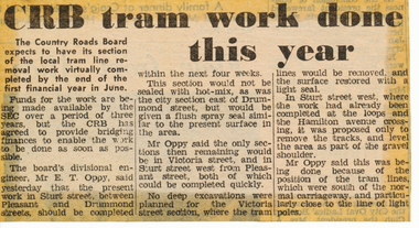
Newspaper, The Courier Ballarat, "CRB tram work done this year", 16/05/1972 12:00:00 AM
Newspaper clipping from The Courier, Ballarat, dated Tuesday 16/5/1972, titled "CRB tram work done this year". Item reporting on the plans of the CRB regarding the pace of removing the tram track on their roads. Quotes Divisional Engineer, Mr. E. T. Oppy that work should be completed by the end of the financial year. Reports on plans for Victoria St., Sturt St., Sturt St. West. One of a large group of newspaper cuttings from John Bainbridge, 7/4/02.track removal, crb, sturt st, sturt st west, victoria st -
 Ballarat Tramway Museum
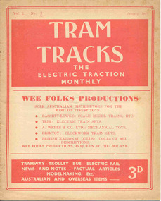
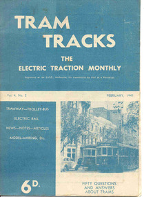
Magazine, Jack Richardson, "Tram Tracks - The Electric Traction Monthly", Jan to June 1947
Six issues of "Tram Tracks - The Electric Traction Monthly" of the Australian Electric Traction Association. Each issue has a standard cover, of the magazine name etc, featuring "Wee Folks Productions" models but are in different colours, all have been saddled stapled with two staples, except No. 6. The Volume and date details have been over printed. Back covers inside back covers have the same advertisements but the font varies vary. The six issues contain advertisements for the Wee Folks productions, Hartleys Sports store, Hearns Hobbies, Wattle Park, Johnson's Variety Store, Barnes Tennis Centre, The Model Dockyard, Robilt Models, Meadmore Model Engineering and Austral Bronze Pty Ltd, Hearns Hobbies, Christie Scale Model Railway and Equipment, Herbert Small (Meccano), the American Subscription Agency, Manufacturers' Mutual Insurance Ltd. 2465.1 - Vol. 2 No. 1 - 16 pages, Jan 1947, with cover printed in red. Has articles on the tram / car debate, Dunedin Tramways, Overlapping fare sections, type of trucks under Sydney tramcars, Brisbane Electric Railway (Power station), The Balmain Counterweight and Trolley buses in Australia. News items include Brisbane, Newcastle, Sydney, Melbourne, SEC, Hobart, VR, Adelaide, Kalgoorlie, Broome, electric trains in Melbourne and Sydney, and AETA notes. Photos include Sydney O, OP and P, VR PERM 63 and interior photo of a MMTB W4 class tram. 2465.2 - Vol. 2, No. 2 - 16 pages, Feb. 1947, with cover printed in dark blue. Has articles on Brisbane 400 class tramcar, Adelaide to Glenelg Brighton - Le Sands tramway, Melbourne Suburban railways, Diesel Electrics on the Southern Railway (US)and Birney Safety Car. News items include Brisbane, Sydney, Melbourne, VR, Fremantle and AETA notes. 2465.3 - Vol. 2, No. 3 - 12 pages, Mar. 1947, with cover printed in brown. Has articles on why NSW trams lose money, Duncan and Frazer, new trams in Johannesburg, Melbourne Suburban railways, and Sydney New Railway (Eastern Suburbs). News items Sydney, Melbourne, SEC, VR and Adelaide and AETA notes. 2465.4 - Vol. 2, No. 4 - 16 pages, Apr. 1947, with cover printed in green. Has articles on Duncan and Fraser (continued), In search of Ancient Warriors (old trams), Brisbane Electric Railway and some unusual fares arrangements. News items include Brisbane, Newcastle, Melbourne, Sydney, SEC, Launceston, Kalgoorlie, overseas, and AETA notes. Editorial looks at claims that the SW6 cars are the finest in the world, back numbers (notes that Tram Tracks started with a mimeographed club news sheet and now have circulation of nearly 200), costs of production etc. Has photographs of the interior of a SW6 850, a plan for Melbourne underground railway, the VR power operations room at Flinders St., Hobart trolley bus and a cartoon about Sydney traffic. 2465.5 - Vol. 2, No. 5 - 16 pages, May 1947, with cover printed in red. Has articles on Australian Light railways, Sydney's relief lines and the start of an article on NSWGT 600/1200V tramcars. Has news items on Brisbane, Sydney, MMTB, VR, Geelong, Ballarat, Launceston, Hobart and AETA notes. Editorial notes the first anniversary of the magazine and has a number of letters regarding this, content and the tram/car debate. 2465.6 - Vol. 2, No. 6 - 20 pages, June 1947, with cover printed in blue. Has articles on Cremorne bridge replacement (with photos), Neutral bay line and Tramcar transmission gears. News items include photos of MMTB track replacements, crowded trams, Brisbane, Sydney, Melbourne, and a photo of a Sydney tram passing under the new bridge work for Circular Quay station. 2465.7 - Vol. 2, No. 12 - pages 1-12, cover has an advert for Hartley Sporting Goods. Has cartoon on fares on Sydney trams by Peterson, not regarding retirement of Mr. H. Bell of MMTB, Melbourne Latrobe St and bus construction, Sydney tram cartoons from Emile Mercier, electric trains and other tramway news. (Item added 24-3-18 - from consolidation of Melbourne Tram Museum and BTM collections) trams, tramways, electric traction, aeta, models, australian tramways, duncan fraser, cartoons -
 Ballarat Tramway Museum
Magazine, Jack Richardson, "Tram Tracks - The Electric Traction Monthly", Feb. 1949 to August 1949
2467.1 - Vol. 4 No. 2, February 1949 of "Tram Tracks - The Electric Traction Monthly" of the Australian Electric Traction Association. Magazine consists of 16 printed pages with a 12 page supplement titled "Fifty Questions and Answers about trams in Australia". Has a single staple on the saddle. Incorporated within the magazine are articles or editorials on Tramways and Tramway Experts (Sydney and bus replacement), Interurban to St Kilda (conversion of VR St. Kilda line). General news items on Brisbane, Geelong, Launceston closure, Hobart, Bourke St routes, Perth, Adelaide, NSW, Christchurch, Overseas tramways and railways. Also has letters to the Editor, plans of a Birney tram for model makers and AETA Notes. Issue has advertisements for the Model Dockyard, ARLHS, The Hobby Shop, Barnes Tennis Centre, Fleet, Christie Model Railway Equipment of Sydney, Meadmore Model Engineering, Austral Bronze, Wattle Park, Traction Publications and Robilt "O" gauge locomotives. 2467.2 - Vol 4, No. 5 - May 1949 - 20 pages - red cover, 4th year, article by Peter Duckett with photos of Board members, "PCC Trucks here", MMTB advert for staff, news from Sydney, Newcastle, Melbourne (applications for new Chairman to replace Mr. Bell), Bendigo, Perth, Christchurch, Wellington, Wanganui, Bourke St construction work (photo of poles), Brisbane tramway history, map of CBD Melbourne, Melbourne and Sydney suburban railways, AETA News. 2467.3 - Vol 4, No. 6 - June 1949 - 16 pages - green pages, tramways and private cats, news from Sydney, Newcastle, Melbourne, Launceston, Hobart, article "Scrap Sydney Tams by 1960 - Newcastle this years say London experts", buses tackle football crowds (Sydney), Fremantle (Wal Jack letter), and Melbourne and Sydney suburban railways, AETA News. 2467.4 - Vol 4, No. 7 - July 1949 - 16 pages - tramways and the public, news from Sydney, Newcastle, Melbourne, appointment of R. Risson as new chairman, Perth, Adelaide, Launceston, tramcar solenoid brakes, National City Lines USA, and Melbourne and Sydney suburban railways, AETA News. 2467.5 - Vol 4, No. 8 - August 1949 - 8 pages - tramways and politics, photo of new points for Latrobe and William Sts, East Hills Line by C. C. Singleton, general tramway news, and advertisement for Robilt model railways. .2 to .4 added 15-2-2016 from the collection of Ian Stanley. .5 added 24-3-18 - from consolidation of Melbourne Tram Museum and BTM collections)trams, tramways, electric traction, aeta, australian tramways, mmtb, pcc, closure, sydney, newcastle, brisbane -
 Ballarat Tramway Museum
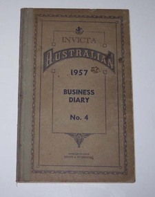
Administrative record - Log book, Diary, Sands McDougall Pty Ltd, 1956
Yields information about the track maintenance activities of the track gang in Ballarat, the work they did, notes, names and other information.Invicta Australian 1957 Business Diary, No. 4, printed by Sands and McDougall, light brown Rexene binding, card covers, sewn sections with ruled sheets providing a diary for 1957, one week per double page. Has "useful information" sheets at from the diary. Used by the SEC Ballarat track gang to record their daily work, leave, welding, track cleaning, truck driver etc Rear pages - has notes on materials used. Loose contents 1 - 18/11/1957, note dated 26/9/57 to track foreman re work at the Cooling Tower, B station. 2 - 23/12/1957 - envelope address to H. Smith Tracks - with Yallourn Briquettes sales department logo and address details. 3. - Inside rear cover - plan of hospital corner - showing plan of broken joints? tram, trams, sec, ballarat, depot, trackwork, rails -
 Ballarat Tramway Museum
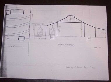
Document - Photocopy, Alan Bradley, "Plan and Front Elevation of Car Depot", 2000
Set of three A3 size photocopies of a drawing held by the Public Records Office Victoria of the Ballarat ESCo Tramway Depot, dated 2/8/1912. Drawn at a scale of 1/16" = 1', shows building layout, track layout, overall dimensions, a proposed extension to hold eleven trailers, a front elevation showing pits, extension (drawn at 1/8" = 1'). On the current tracks, shows the individual track capacities - 26 trams. Drawings copied by Alan Bradley for archives and research.trams, tramways, ballarat, esco, depot, drawings -
 Ballarat Tramway Museum
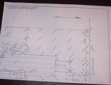
Document - Photocopy, Alan Bradley, "Car Depot / Wendouree Pde.", 2000
Set of four A3 size photocopies of a drawing VB4/8709c held by the Public Records Office Victoria of the Ballarat SEC Tramway Depot, dated 5/11/1971, Revision C 22/11/1971. Drawn at a scale of 1" = 20', shows building layout, track layout, overall dimensions, tree locations, pit details, rooms, paint shop, reduced levels, streets, toilets, steps to pits, tennis court and datum point. Drawn after the closure of the tramways, possibly to enable planning for the redevelopment and sale of the property. Drawings copied by Alan Bradley for archives and research.trams, tramways, ballarat, sec, depot, drawings -
 Ballarat Tramway Museum
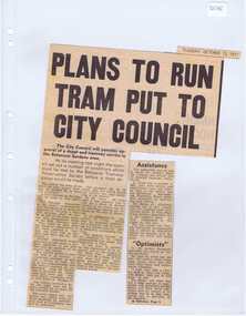
Newspaper, The Courier Ballarat, "Plan to run tram put to City Council", 12/10/1971 12:00:00 AM
Newspaper clipping from The Courier, 12/10/1971, titled "Plan to run tram put to City Council" about the City of Ballaarat considering plans from the BTPS for the construction of a depot in the South Gardens Reserve, consideration of a grant of $750 for the sheltering of tram No. 14. Quotes President Hal Cain about the proposals of the Society, and elements of the submission to council requesting assistance to run the track from View Point to Carlton St. Sir Arthur Nicholson said "super optimists", refers to the editorial.. Cutting in two parts.btps, depot, city of ballarat, preservation -
 Ballarat Tramway Museum
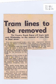
Newspaper, The Courier Ballarat, "Trams lines to be removed", 18/09/1971 12:00:00 AM
Newspaper clipping from The Courier, Ballarat, 18/9/1971 titled "Tram lines to be removed", reporting on the planned removal of the tram lines commencing next week on a block by block approach in Sturt St by the Country Roads Board (CRB) in conjunction with the City of Ballaarat.closure, track removal, sturt st, crb, city of ballaarat -
 Ballarat Tramway Museum
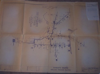
Drawing, State Electricity Commission of Victoria (SECV), "Schematic Diagram Geelong Tramway Routes", 1953
The drawing is very detailed showing streets, cross streets, route, loops, schools, woollen mills, ovals, sections, track phones, stops, route and track miles, pedestrian crossings, railway stations and notes on through route mileages.Print of a drawing showing in very good detail, the schematic layout of the Geelong Tram system. Produced in 1953 and sent to Tramway Supt. in 1970 for his records. Gives very detailed information on another SEC tramway system.Dyeline print of SEC Drawing No. GE-T13-8829, titled "Schematic Diagram Geelong Tramway Routes". Drawing prepared 27/8/1953. Stapled to the top right hand corner of the sheet is a SEC memo form from finance section, distribution services to the Dept. Tramway Superintendent, Ballarat, dated 6-2-1970 forwarding Les Denmead the plan. Was unstapled during the 1/2008 copying of the drawing. On top right hand corner of drawing, "Ballarat Tramway Preservation Society Catalogue No. 605" in ink and on rear in two places "Geelong Tramways" and one "BTPS 605"geelong, map, track layout, tram stops -
 Ballarat Tramway Museum
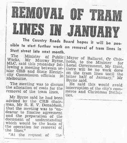
Document - Photocopy, Alan Bradley, "Removal of tram lines in January", Apr. 2005
Yields information about the planning behind the work to remove the tram lines in Ballarat following closure and the consultation with the City of Ballaarat.Photocopy of an item from The Courier, late 1971, titled "Removal of tram lines in January", about the removal of the tram lines in the City CBD by the Country Roads Board, from the later half of January 1972. Noted a meeting between CRB, SEC officials. Includes a note on the consultation with the Mayor of Ballarat, Cr. Chisholm.trams, tramways, track removal, crb, sec -
 Ballarat Tramway Museum
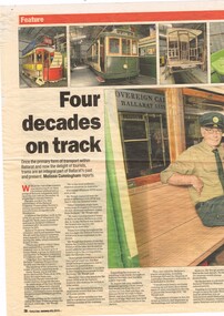
Newspaper, The Courier Ballarat, "Four decades on track", 10/01/2015 12:00:00 AM
Newspaper clipping from The Courier, Saturday 10 January 2015, titled "Four decades on track", report by Melissa Cunningham about the 40 years of operations by the BTPS / BTM. Looks at the history of the Museum, its future plans, solar panels, heritage tramways, Sovereign Hill. Quotes Roger Gosney and Peter Waugh. Has photos of 1, 27, 12, 18 and the interior of the display tram 39. btm, ballarat, btm depot, btps -
 Ballarat Tramway Museum
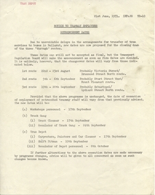
Administrative record - Memorandum, State Electricity Commission of Victoria (SECV), "Notice to Tramway Employees - Retrenchment Dates", 21/06/1971 12:00:00 AM
Yields information about the planning for the closure of the tramway system in Ballarat by the SEC and the way the retrenchment of staff would be arranged., Yields information about the planning for the closure of the tramway system in Ballarat by the SEC and the way the retrenchment of staff would be arranged.Duplicated quarto sized memorandum titled "Notice to Tramway Employees - Retrenchment Dates", dated 21 June 1971, giving advice of the possible change over dates and likely termination dates for Workshops personnel, Track cleaner, track gang and depot staff. Has "Tram Depot" typed in top left hand corner.trams, tramways, closure, ballarat, sec, depot -
 Ballarat Tramway Museum
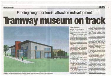
Newspaper, The Courier Ballarat, "Tramway museum on track" - "funding sought for tourist attraction development", 28/03/2014 12:00:00 AM
Newspaper clipping from The Courier, Friday 28/3/2014, page 7, titled "Tramway museum on track" - "funding sought for tourist attraction development", with an image of the Museums plan for the addition to the existing building. Includes information provided by Paul Mong, business case, creating jobs. Two copies collected.On front or rear of the cutting, information re dates etc.btm, museum -
 Ballarat Tramway Museum
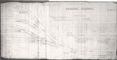
Drawing, Original by Hadfield's and print by Warren Doubleday, "Ballarat Plan 6", 1995
... a new depot for Ballarat - the track plan proposed ...Yields information about a new depot for Ballarat - the track plan proposed but not followed through for ESCo. Gives the layout and the proposed manufacturer Hadfield's.Print made from a microfilm using a microfilm printer, of "Ballarat Plan 6", a drawing showing trackwork for a new tram depot proposed for the ESCo owned property near the power house. Shows an 8 track tram depot in association with existing Wendouree Parade trackwork. Prepared by Hadfield's Sheffield, drawing No. 6745 as Plan No. 6. Gives details of the proposed rail weights - 90lb and 83lb and location details. Drawing held as one complete assembled print and two part prints. The assembled print was scanned. Note not printed at full size. See Alan Bradley article on the Power Station and power supply to Ballarat.depot, trackwork, ballarat, esco, hadfield's -
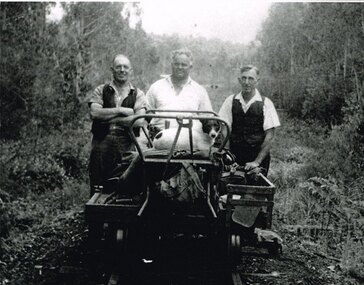 Otway Districts Historical Society
Photograph, Albert Denning, Colac track gang near Kawarren, c.1950
In 1955 staff numbers were reduced to an absolute minimum with one track gang at Beech Forest and one at Colac, one of whose members resided at Gellibrand. No new sleepers were issued to the track gangs after 1955/56, cut down ones being used instead. Albert Denning, the son of a Gellibrand selector, worked at Driver's planing mill and Hitt's Lardner mill before joining Victorian Railways in 1928 as an engine cleaner at Beech Forest and Crowes, the last one in both places. He later became a track repairer at Gellibrand and worked with this and the Colac track gang until 1962. Bill Jamieson was a track repairer on the Colac-Gellibrand gang from the 1950s until 1962, and witnessed the official policy of minimum maintenance in the last years of the line.B/W. 201mm x 254mm. In c.1950, the Colac track gang near Kawarren, featuring, from left to right, Bill Jamieson, Albert Denning, and Don Loury on an NKS motor trolley..colac; kawarren; railways; track gangs; -
 Otway Districts Historical Society
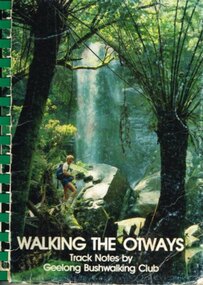
Book, Geelong Bushwalking Club Inc, Walking the Otways, November 1986
The Otways area of Victoria, at the time of writing, was an underused area for bushwalking. In the past, people have considered these ranges unsuited for walking because of the thick forest cover, cold and muddy conditions for much of the year, and the steep slopes. Some of the perceived difficulties are actually attractions and that it is possible to enjoy them with a forward planning and up-to-date information to guide the walker.The Geelong Bushwalking Club have included some useful but brief articles on basic aspects of bushwalking.Walking the Otways. Track notes compiled by the Geelong Bushwalking Club. Graeme Allen (ed.); John Van Gemert (maps, photographs). 1st ed. Geelong Bushwalking Club; Geelong (Vic); November 1986. 148 p.; illus, maps. Soft cover.otways; bushwalking; -
 Ballarat Tramway Museum
Newspaper, Ballarat Times News Group, 11-11-2022
Newspaper report from the Ballarat Times regarding a Liberal party pledge to extend the Ballarat Tramway Museum line in Wendouree Parade by Samantha McIntosh. Has a photo of Paul Mong and Samantha standing in front of Cuthberts 939.Yields information about a Liberal Party 2022 Election campaign in Ballarat.Digital Image of a Cutting from the Ballarat News 11-11-2022 re Liberal Party plan to extend the tramway to Durham Pointbtm, track extension, new tramways, liberal party, samantha mcintosh -
 Ballarat Tramway Museum
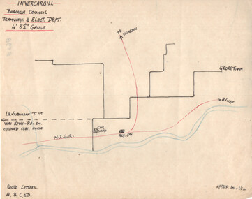
Drawing - Invercargill NZ - Plan and Notes, Wal Jack, 1947
Wal Jack had an extensive range of correspondents throughout Australia and the world who often provided him with detailed drawings and notes on various tramway systems. This set of notes on the Invercargill tramway system, provides details of the tram system and a list of the rolling stock and track length. Based on the handwriting, prepared by Wal Jack himself. Yields information about Wal Jack's extensive recording and research work.Drawing - black, red and blue ink or colour pencil and a second sheet, both on quarto paper providing details of the Invercargill NZ tramway system.tramways, wal jack, drawings, maps, tramcars, invercargill -
 Ballarat Tramway Museum
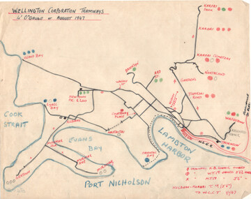
Drawing - Wellington NZ - Plan and Notes, Wal Jack, August 1947
Wal Jack had an extensive range of correspondents throughout Australia and the world who often provided him with detailed drawings and notes on various tramway systems. This set of notes on the Wellington NZ tram system provides a list of tramcars, track layout and general notes. Dated August 1947. Based on the handwriting, prepared by Wal Jack himself. Yields information about Wal Jack's extensive recording and research work.Drawing - black, red and blue ink or colour pencil and two quarto sheets hand made.tramways, wal jack, drawings, maps, tramcars, wellington nz -
 Ballarat Tramway Museum
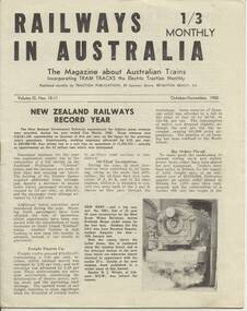
Magazine, Traction Publications, Railways In Australia - Oct/Nov 1950, Nov. 1950
24 page magazine, publisher by Traction publication recording current event in Australia & New Zealand railways & tramways - with photos, advertisements, see list for contents. Railways in Australia The Magazine about Australian Trains, incorporating TRAM TRACKS, the Electric Traction Monthly Contents (Summary) Articles New Zealand Railways - Record Year - pl, 2 and 3 Diesel operation of South line is SAR plan - p2 Comrails plan big improvements - p3 New north line soon for NSWR? - p3 About Locomotives - QGR Garratt's, VR N class, R class, NSW 58, TGR diesels - p4 and 5 Holiday by Rail - C.Einsiedel - Vic and NSW Comparisons are Odious - An American View - PCC tram for MMTB - p9 More Fare increase - Sydney, Melbourne and elsewhere - p10 Operation 'Strike' - Melbourne Trams Handle Crowds - by KSK - p 1 2 and 13 (VR trains on strike) - very interesting. - has map of ~B including authorised lines. High Voltage ~ Electric Railway news - NSW, VR, Gippsland - p 14 Model Railways in Australia - p 1 8 and 19 The Mayfield Lines ( large garden 0 gauge model railway, by L.A. Clark, includes plan - p20 and 2 I.) Photographs NSW steam loco 5801 - pl TGR diesel railcars built by Comeng - p3 NSW 38's - p4 MMTB PCC tram 980 and interior view - p9 Photo of St Louis Car Co. B3 bogie used under PCC car - p10 Perth Trolley Bus - No. 41 - p 1 3 Advertisements McGills Newsagency - p2 John C. Beckett - photographer - p6 Meadmores model engineering Co. - p6 and p 14 WAGR institute magazine - p6 Wattle Park - p7 Australian Model Hobbies - SA - p 1 5 Traction Publications - p 1 5 The Main Hobby Depot - Melbourne - p 1 5 Railway Destination Rolls, LA Clark - pl 5 Model repairs - R.Pearson - p19 Hearn's Hobbies- p21 The Hobby Shop p21 Herbert Small - p21 Australia Railway Models - p22 Scale Model Railway Equipment - p23 Bames Tennis Centre - p23 Traction publications listings and books etc. - p24 - and where to purchase magazine. Amalgamated Blind and Tent Co. - p24 Other List of office bearers and general information for ARLHS Obituary for Maj Gen. A.C.Fewtrell Chief Civil Engineer for NSWGR Tramway news - Sydney King St. Closure, Wanganui system closure, Latrobe St. Melbourne, Melbourne VR trams, SEC trams purchasing maximum traction trams, Launceston, Hobart, Kalgoorlie - p I 1, Brisbane, Perth and Adelaide - p I 5 Drawing of Adelaide H class trams - p 1 9 Club noticeboard, and Question box - on Outer circle Railway. Wad 25.11.95 Record images added 20/8/2013. trams, tramways, australian railways, new zealand railways, model railways, model tramways -
Kew Historical Society Inc
Journal, Kewriosity : August 1991
The greening of Kew [Street Tree Masterplan] / p1. Free mulching of prunings / p1. Looming threat to the character of Kew [Victorian Government plans for medium-density housing] / p1. Diary dates for August / p2. Free self-defence and relaxation classes / p2. Anonymous house [house numbering requirements] / p2. Tom's incredible Spider Ring! ['The Spider Ring' by Track Players] / p2. Commentary / Cr Daryl Oldaker p3. Chief Executive's Column [Property valuations] / p3. Looking down rat holes [storm water drain audit] / p4. Waste plans not half baked [120 Litre Mobile Bin Recycling Trial] / p4. Lower your gas and electricity bills [Kew Community House workshops] / p4. Tribute to John Fleet Maughan 1898-1991 [City Engineer 1924-63] / p4. Indoor celebration of parkland [opening of Burke Road to High Street section of Outer Circle Linear Park] / p5. Forward planning for youth [survey] / p5. Kew saves an endangered species [Studley Park Red Gum - E.Studleyensis] / p5. Compliments, criticism and complaints [Kew Library Comments Book] / p6. Life in East Kew / Mr Tony de Clifford p6. New face [Pierrette Boustany, Outside School Hours Co-ordinator] / p6. New face [Lisa Gaffney, Public Relations Officer] / p6. Kewriosity deadlines / p6. Advertising [charges] / p6. Thankyou to the volunteers of Kew / p7. Another Anniversaire [Count Francoise de la Perouse] / p7. Heartfelt thanks [donation by East Kew Synagogue congregation to Kew Citizens' Advice Bureau] / p7. Kew Rotary Club good works / p7. Cinema to expand [Balwyn Cinema] / p7. Winter Song [Brian Hansford performs 'Winterreise at St John's Hall, Camberwell] / p8. Come to Cameron Country [Donald Cameron et al at Kew Gallery] / p8. You be the Gypsy [Victor Herbert's 'Gipsy Lady' by Viola Musical Comedy Society] / p8. Classical music in Kew [Kew Philharmonic Society] / p8.Kewriosity was a local newsletter combining Kew Council and community news. It was published between November 1983 and June 1994, replacing an earlier Kewriosity [broad] Sheet (1979-84). In producing Kewriosity, Council aimed to provide a range of interesting and informative articles covering its deliberations and decision making, together with items of general interest and importance to the Kew community and information not generally available through daily media outlets.non-fictionThe greening of Kew [Street Tree Masterplan] / p1. Free mulching of prunings / p1. Looming threat to the character of Kew [Victorian Government plans for medium-density housing] / p1. Diary dates for August / p2. Free self-defence and relaxation classes / p2. Anonymous house [house numbering requirements] / p2. Tom's incredible Spider Ring! ['The Spider Ring' by Track Players] / p2. Commentary / Cr Daryl Oldaker p3. Chief Executive's Column [Property valuations] / p3. Looking down rat holes [storm water drain audit] / p4. Waste plans not half baked [120 Litre Mobile Bin Recycling Trial] / p4. Lower your gas and electricity bills [Kew Community House workshops] / p4. Tribute to John Fleet Maughan 1898-1991 [City Engineer 1924-63] / p4. Indoor celebration of parkland [opening of Burke Road to High Street section of Outer Circle Linear Park] / p5. Forward planning for youth [survey] / p5. Kew saves an endangered species [Studley Park Red Gum - E.Studleyensis] / p5. Compliments, criticism and complaints [Kew Library Comments Book] / p6. Life in East Kew / Mr Tony de Clifford p6. New face [Pierrette Boustany, Outside School Hours Co-ordinator] / p6. New face [Lisa Gaffney, Public Relations Officer] / p6. Kewriosity deadlines / p6. Advertising [charges] / p6. Thankyou to the volunteers of Kew / p7. Another Anniversaire [Count Francoise de la Perouse] / p7. Heartfelt thanks [donation by East Kew Synagogue congregation to Kew Citizens' Advice Bureau] / p7. Kew Rotary Club good works / p7. Cinema to expand [Balwyn Cinema] / p7. Winter Song [Brian Hansford performs 'Winterreise at St John's Hall, Camberwell] / p8. Come to Cameron Country [Donald Cameron et al at Kew Gallery] / p8. You be the Gypsy [Victor Herbert's 'Gipsy Lady' by Viola Musical Comedy Society] / p8. Classical music in Kew [Kew Philharmonic Society] / p8. publications -- city of kew (vic.), kewriosity, council newsletters, community newsletters -
Kew Historical Society Inc
Journal, Kewriosity : August 1990
Council assistance available to maintain homes / p1. Rates reminder / p1. No elections / p1. Dates for August / p2. Breast information session / p2. One act plays [Track Players] / p2. Strategies for success / p2. Rotary changeover [Kew Rotary Club] / p2. Kew's kindergartens to open doors / p3. Budget to take care of basics / p3. Urban women have a taste for country life [Kew/Balwyn Country Women's Association CWA] / p3. Your community bus needs you / p3. Recruiting drive [Meals on Wheels] / p3. Notices / p4. Major donation to St George's [Hospital] [Kew Rotary Club] / p4. Carey's new head / p4. Library corner / p4. Update on traffic / p4. Family day care / p5. Centenary celebrations for Kew East [Primary School] / p5. Courses, coffee and a chat [ Kew Community House] / p5. Govt amends Kew Planning Scheme [Willsmere] / p5. Backyard burning banned / p5. Kew Community House [courses] / p6. Clean up for Studley Park [Boroondara Bushwalkers] / p6. Council re-assesses proposal [skateboard bowl at Victoria Park] / p6. Meetings promote care giver act / p7. Council seeks community reps / p7. Kew Primary promotes its assets / p7. Recipe for success [Children's International Summer Villages] / p8. Special paper collection / p8. "Kew is for Living" [Kew Festival] / p8.Kewriosity was a local newsletter combining Kew Council and community news. It was published between November 1983 and June 1994, replacing an earlier Kewriosity [broad] Sheet (1979-84). In producing Kewriosity, Council aimed to provide a range of interesting and informative articles covering its deliberations and decision making, together with items of general interest and importance to the Kew community and information not generally available through daily media outlets.non-fictionCouncil assistance available to maintain homes / p1. Rates reminder / p1. No elections / p1. Dates for August / p2. Breast information session / p2. One act plays [Track Players] / p2. Strategies for success / p2. Rotary changeover [Kew Rotary Club] / p2. Kew's kindergartens to open doors / p3. Budget to take care of basics / p3. Urban women have a taste for country life [Kew/Balwyn Country Women's Association CWA] / p3. Your community bus needs you / p3. Recruiting drive [Meals on Wheels] / p3. Notices / p4. Major donation to St George's [Hospital] [Kew Rotary Club] / p4. Carey's new head / p4. Library corner / p4. Update on traffic / p4. Family day care / p5. Centenary celebrations for Kew East [Primary School] / p5. Courses, coffee and a chat [ Kew Community House] / p5. Govt amends Kew Planning Scheme [Willsmere] / p5. Backyard burning banned / p5. Kew Community House [courses] / p6. Clean up for Studley Park [Boroondara Bushwalkers] / p6. Council re-assesses proposal [skateboard bowl at Victoria Park] / p6. Meetings promote care giver act / p7. Council seeks community reps / p7. Kew Primary promotes its assets / p7. Recipe for success [Children's International Summer Villages] / p8. Special paper collection / p8. "Kew is for Living" [Kew Festival] / p8. publications -- city of kew (vic.), kewriosity, council newsletters, community newsletters -
Kew Historical Society Inc
Journal, Kewriosity : October 1986
Focus on Children's Services [Children's Services Consultative Committee (CSCC)] / Elizabeth Sullivan p1&5. Kew is safe! [Local Government re-organisation] / p1. A gentle reminder about Kew's By-laws [overhanging trees] / p1. Dates for October / p2&8. [Community] Notices / p2&8. Commentary [How Council manages traffic] / Cr Joe Ormando, Mayor of Kew p3. Good gardening [Growing lawns] / Peter Davies p3. Profile - Cr Jim Tutt / p4. Radio controlled car track for Foley Park / p4. Focus on children [Focus on Children Report] / p5. Cap/disability / Craig Midgley p5. Doing something worthwhile [Interchange; Relief care for children with disabilities] / p6. Our bands are winners! [Kew Citizens' Band; Kew Junior Band] / p6. Would you like to be an honorary probation officer? / p6. Kew Community House [Annual dinner; A range of courses; Annual General Meeting; Your house] / Rhonda McCaw p7. Planning for retirement [Kew Early Planning for Retirement Group] / p7. Anyone for tennis? [Kew Uniting Church Tennis Club] / p8. Footy news [Kew Football Club] / p8. Keeping you informed [Citizens' Advice Bureau] / p8. Letter - Staff refute rumours about Library / Staff of Kew Library p8. Ever thought about playing Bowls [East Kew Bowling Club] / Gerard Petrie p8.Kewriosity was a local newsletter combining Kew Council and community news. It was published between November 1983 and June 1994, replacing an earlier Kewriosity [broad] Sheet (1979-84). In producing Kewriosity, Council aimed to provide a range of interesting and informative articles covering its deliberations and decision making, together with items of general interest and importance to the Kew community and information not generally available through daily media outlets.non-fictionFocus on Children's Services [Children's Services Consultative Committee (CSCC)] / Elizabeth Sullivan p1&5. Kew is safe! [Local Government re-organisation] / p1. A gentle reminder about Kew's By-laws [overhanging trees] / p1. Dates for October / p2&8. [Community] Notices / p2&8. Commentary [How Council manages traffic] / Cr Joe Ormando, Mayor of Kew p3. Good gardening [Growing lawns] / Peter Davies p3. Profile - Cr Jim Tutt / p4. Radio controlled car track for Foley Park / p4. Focus on children [Focus on Children Report] / p5. Cap/disability / Craig Midgley p5. Doing something worthwhile [Interchange; Relief care for children with disabilities] / p6. Our bands are winners! [Kew Citizens' Band; Kew Junior Band] / p6. Would you like to be an honorary probation officer? / p6. Kew Community House [Annual dinner; A range of courses; Annual General Meeting; Your house] / Rhonda McCaw p7. Planning for retirement [Kew Early Planning for Retirement Group] / p7. Anyone for tennis? [Kew Uniting Church Tennis Club] / p8. Footy news [Kew Football Club] / p8. Keeping you informed [Citizens' Advice Bureau] / p8. Letter - Staff refute rumours about Library / Staff of Kew Library p8. Ever thought about playing Bowls [East Kew Bowling Club] / Gerard Petrie p8. publications -- city of kew (vic.), kewriosity, council newsletters, community newsletters -
 Kew Historical Society Inc
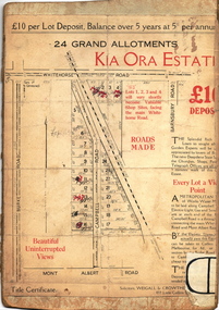
Plan - Subdivision Plan, Kia Ora Estate, 1930s
Twenty-five grand allotments were offered for sale in the subdivision known as the Kia Ora Estate in Balwyn in the early 1930s. The streets identified in the subdivision include Whitehorse Road, Barnsbury Road, Campbell Road, Mont Albert Road and Burke Road. The lots were advertised for £10 deposit, with the balance to be paid over 5 years at 5 per cent per annum. The lots bordering Whitehorse Road were nominated as potential valuable shop sites, while the Mont Albert Road lots were advertised as having ‘wonderful views’. The Outer Circle Railway Line is shown traversing the subdivision. The route of the Railway in this area is now a walking/bike track bordered by strips of parkland.subdivision plans - balwyn, kia ora estate -
Tarnagulla History Archive
Photograph - Photograph: Company's Dam and Flour Mill, Tarnagulla, c. 1880 - 1920
Williams Family Collection. On the 20th December 1873 it was reported in the Tarnagulla Courier that arrangements were being made for the erection of a steam flour mill at Tarnagulla. Mr Bristol had purchased the necessary plant which would be erected with as little delay as possible. The site chosen was the premises occupied previously by Mr John Pierce, grocer and wine and spirit merchant, at the corner of King and Commercial Road. These premises were incorporated in the mill building. Suitable buildings for receiving and storing grain and flour had been erected already. On 10th January, 1874 an advertisement in the Courier called for tenders from masons, bricklayers and carpenters for the erection of a flour mill at Tarnagulla for H. C. Bristol, Esq. with all enquiries to be made from G. Minto, Engineer. In December 1881 the proprietors made a request to the Tarnagulla Borough Council for permission to lay pipes to the Municipal Dam, which was generally known as the Company's Dam, and to obtain water from the dam for milling purposes. This was granted. Steam was got up for the first time on 30th of March, 1882. A large quantity of wheat was stored ready for milling. Just prior to 29th of April 1882 the boiler at the mill burst, as the result of which two men, J. H. Smith and W. Hargreaves died and H. Joyce Bousfield, senior and junior, were seriously injured. The mill commenced operations on 13th June, 1882 with Mr W Fitzgerald as manager. The price offered for wheat was thirty-seven pence per bushell. It operated with grinding stones until considerable renovations were done in the early part of 1899 when new rollers and more up to date equipment installed. The mill was then known as the Tarnagulla Flour Mill Co., with Thos. Comrie as proprietor, Mr Fitzgerald was still manager, and Mr T. Leonard was the traveller. Much new equipment was put in and each of the three floors had different processes. The rollers were on the ground floor, the purifiers and elevators reel were on the second floor, plus the clean wheat bin directly over the Ganz rollers. On the top floor was the chop reel, bran reel, inter-elevator reels, brush machine cyclone sack hoist, dirty wheat shaker, clean wheat bin, dust rooms and also double damping rooms. A plant was also erected for the making of an improved quality of wheaten meal, for which purpose special machinery was procured and a pair of stones was left for grinding the meal. A complete plant for the crushing of oats etc was also erected. The driving power of the mill was supplied by a new engine complete with 16 inch cylinder, manufactured and erected by Bousfield & Co. of Eaglehawk. It was fitted with Pickering governors, connected with the cylinder was a super heater. The boiler was tested and all connections etc. overhauled, with much of it being completely renewed. There was a complete network of belts, spouts, elevators etc. all over the building, all conveniently placed. The plans etc for the new plant were drawn up by Mr J. Kilborn, manager of the firm of Bodington & Co., engineers and millwrights of Carlton, which supplied the whole of the machinery, excepting the engine. The work of erection was carried out by Mr Kilborn and his assistants to the entire satisfaction of Mr Comrie, who had gone to considerable expense to bring the mill to a completely up-todate machine, fitted with all of the most modern appliances available. An advertisement on May 6th, 1899 read: "Tarnagulla Flour Mill Co., Patent Roller Flour. Also their Digestive Wheaten Meal specially prepared for Porridge or Bread." In January 1901, 6000 bags of wheat were received weekly at the mill and it was a common sight to see the streets lined with wagons. In May 1902 the mill was lighted by gas and in July 1906 an application was made to the Tarnagulla Borough Council for permission to lay a tram track from the mill to the Railways Station. Council was agreeable to this provided suitable plans were submitted. In 1913, 15,000 bags of wheat were bought at three shillings and four pence per bushell. In January 1914 the mill was renovated. At this time 1500 bags of wheat were coming in daily, with 20,000 bags in storage. On 15th December, 1917 the mill was advertised for sale, to be sold on Friday, 21st December,.1917, on behalf of the Estate of the Late Thomas Comrie, who had died on 4th August, 1910. The Courier at that time recorded him as being responsible for the building of the mill and with being the sole proprietor. The mill was closed, apparently, for a short period. The Courier reported on 13th of September, 1918 that the mill had been sold to Mr O. Albert of Talbot and that it would re-open. An advertisement read: ALBERT. O. & SON, MILLERS. During 1920 the mill was closed and pulled down. It was later re-erected at Mildura where it operated for many years. (by Donald Clark)Monochrome photograph depicting view of Company's Dam and the flour mill in Tarnagulla. Handwritten on reverse: 'J. Caldwell and photographer's stamp 'C. Bock Photo Tarnagulla'.tarnagulla