Showing 186 items matching "trees in victoria park"
-
 Clunes Museum
Plaque - BRONZE PLAQUE
Commemorative plaque of tree planting by Sir Rohan DelacombeBronze plaque commemorating the planting of a tree in Queens Park, Clunes by Maj. Gen. Sir Rohan Delacombe on June 1, 1967This commemorative (illegible word) was planted by his Excellency The Governor of Victoria Major General Sir Rohan Delacombe KCMG., KBE.,CB.,DSO.,KSt.J., 1st June 1967governor of victoria sir rohan delacombe, queens park, 1967, plaque -
 Stawell Historical Society Inc
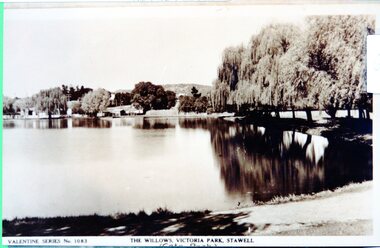
Photograph - View of Cato Lake, Black & White photo of Valentine Series No 1083 Willows Victoria/Cato Lake
View of Victoria/Cato Lake showing just a short section of the walking track and willows around the lake. Houses can be seen in the distance. The lake is very still as the trees are reflected in the water.Black & White photo of Valentine Series No 1083 Victoria/Cato lake. The photo is of a post card of Victoria/Cato Lake. Willow trees line the right side of the photograph. Valentine Series No 1083. The willows Victoria Park, Stawell. stawell -
 Stawell Historical Society Inc
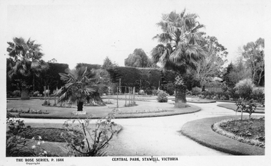
Photograph, Rose Series, Central Park Gardens, c 1910 - 1920
Central Park Gardens Rose Series Postcards P1664. Shows Several Palm trees circular gardens and pathways. c1910-1920.Postcard of The Rose Series P. 1644 Central Park, Stawell. Also included are two enlarged copies of the post card. Post card shows hedge of cypress in the background and various sized Palm trees in round garden beds in the foreground. c1910 - 1920With best wishes for the New year from Bob & Mary written on the back of the post card. Issued by The Rose Stereographs Armadale Victoriastawell, tourism -
 Stawell Historical Society Inc
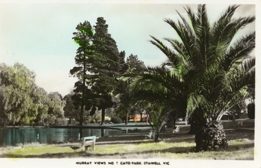
Photograph, Cato Lake -- with palms & trees -- Coloured
Coloured Postcard Murray Views No. 7. Cato Park Stawell Victoria. The three black and white photos are missing the larger palm tree on the right in the foreground. The view is of the lake surrounded by trees and bench seating. One colour post card Murray View No 7 Cato Park Stawell Victoria plus two similar black & white photos one smaller the other an enlargement. Also a small B&W photograph in Album 14, p28. The post card is a view of a section of the lake surrounded by willows, 2 tall pine trees and one large palm tree on the right. The lake is also surrounded by 3 concrete & wood bench seats with maybe a 4th in the distance. Murray View No 7 Cato Park Stawell Vic. On the back "Post Card Real Photograph produced in Australia by Murray View, Gympie, Q".stawell -
 Stawell Historical Society Inc
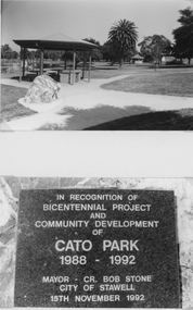
Photograph, Cato Park BBQ Shelter with Tables & a Stone Plaque c 1992 -- 2 Photos
Two black & white photos one of the BBQ shed, with the Rotunda in the background. The second photo is of the plaque in recognition of the Bicentenary project c 1992. The Rotunda near Victoria St was restored to its former glory by members of Stawell Lions Club. A state wide competition for the design of the Rotunda was run in c 1914 and Mr. R.C. (Robert) Henderson of Stawell won the competition and received a Medal as his prize on 19th Nov. c 1914. The Rotunda would have been built within the next 10 years.Two black & white photos one of the BBQ shed, with the stone plaque in the foreground and Rotunda in the background. The second photo is of the stone plaque in recognition of the Bicentenary project c 1992. The Rotunda near Victoria St can just be seen behind and to the right of the BBQ shed a Palm tree is between the Rotunda and BBQ shed. The second photo has information regarding the Bicentennial Project and Community development of Cato Park from 1988-1992. A state wide competition for the design of the Rotunda was run in c 1914. Mr. R.C. (Robert) Henderson of Stawell won the competition and received a Medal as his prize on 19th Nov. c 1914. The Rotunda would have been built within the next 10 years.stawell -
 Stawell Historical Society Inc
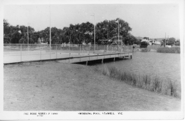
Photograph, Cato Lake with the Swimming Pool c 1950's
Two black and white post cards of the Olympic swimming pool in Cato lake c 1950's. The Rose Series P 14901 shows the swimming pool and lake with the swimming pool dominating the photograph. Four flag posts are clearly visible and the pool connected to the edge of the lake. The Rose Series P 14012 also shows the Olympic pool but more of the lake and boundary. with seating around the lake. In March 1957 Cato Lake was emptied for construction of the Olympic pool and officially opened on 15.11.1958. Twenty seven years later In January 1985 the pool was found to be leaking and Borough Council in February banned further use of the Olympic pool. Eventually the Olympic pool was demolished in April 1988.Two black & white Rose series post cards of Cato Olympic swimming pool Stawell Vic. c 1950's. Series P 14901 is nearly a complete view of the Olympic pool with four flag posts in view and trees and buildings in the distance. Series P 14012 has only a small section of the Olympic pool in the photograph with just 3 flag poles in view. There are 2 concrete and timber seats in the foreground and Cato lake is very still, reflecting the distance trees.The Rose Series P 14901 Swimming Pool Stawell Vic. and The Rose Series P 14912 Cato Park and swimming pool Stawell, Vic. Both post cards were Published by Rose Stereograph Co., Armadale, Victoria. The "Rose" series De Luxe.stawell -
 Stawell Historical Society Inc
Photograph, Cato Lake -- Willow Walk
Valentine Series No 1083 The Willows Victoria Park. This photo was possibly taken before the diving tower and change rooms were erected. The Victoria Park name was changed to Cato Park in 1930.Two original Valentine Series and one enlarged black and white photograph of Victoria Park later called Cato Park. The two Valentine Series No 1083 show the willows to the left and buildings hidden by trees in the distance surrounding the lake. The lake is very still and reflective of the trees around the lake.Valentine Series No 1083 The Willows, Victoria Park, Stawell on the back Valentines real phot series Valentine Publishing Co Melbourne & Sydney. written in pencil "Pre 1930 Duplicate of 67.9"stawell -
 National Wool Museum
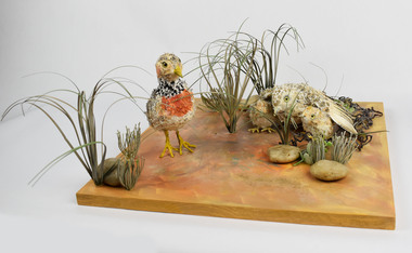
Artwork, other - Paper Taxidermy, Mary-Jane Walker, Plains Wanderer, 2020
The world’s most ecologically distinct bird lives in the native grasslands of Victoria - but only just. The plains-wanderer is a small bird that was once widespread across the grasslands of south-eastern Australia. Today there are fewer than 1000 mature birds in the wild. The plains-wanderer is under threat due to habitat loss caused by overgrazing, cropping and suburban sprawl. Unlike most other birds, female wanderers are larger and more colourful and the males take care of the chicks. They are only about 15cm tall and weigh between 40-80g for the male and 55-90g for the female. Their intricate plumage mirrors the colours of their grassland home so they blend in perfectly with their surroundings. The plains-wanderer’s origins date back to when Australia was part of the Gondwana supercontinent over 60 million years ago. They are so biologically distinct that their extinction would result in the loss of a branch of the tree of life. A fussy grass dweller, they like neither too much nor too little grass. That is where sheep grazing can help. After years of low numbers in Victoria, plains-wanderer populations have been increasing in Terrick Terrick National Park in north west Victoria, as sheep grazing maintains the grass in the park at a suitable level. With the right management, this ecologically important bird species is continuing to survive in the native grasslands of Victoria. Managing these habitats for the plains-wanderer can also support the conservation of many other threatened plant and animal species. Object: Nest of plains-wanderers by Mary-Jane Walker, 2020. Outer made from upcycled paper, internal structure steel. Nest of plains-wanderers by Mary-Jane Walker, 2020. Outer made from up cycled paper, internal structure steel. native grasslands, plains-wanderer, terrick terrick national park -
 Rutherglen Historical Society
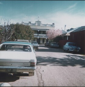
Images, 1970s
One of a collection of photographs from the Iggsten Estate. Woman in photo may be Florence Iggsten. Post Office lane ran from Main Street to Reid Street, and much of it is now the car park for the IGA Supermarket. The Main Street end between the supermarket and the post office is closed to all but pedestrian traffic, and is now called Gollings Square. It is a rest area with trees, garden, sculptures and benches.Colour photograph taken in Post Office Lane, Rutherglen. Roof of the Post Office is visible on the left, and the front of the Victoria Hotel at the end of the road.post office lane, post offices, victoria hotel, florence iggsten, gollings square -
 Rutherglen Historical Society
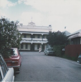
Images, 1970s
One of a collection of photographs from the Iggsten Estate. Post Office lane ran from Main Street to Reid Street, and much of it is now the car park for the IGA Supermarket. The Main Street end between the supermarket and the post office is closed to all but pedestrian traffic, and is now called Gollings Square. It is a rest area with trees, garden, sculptures and benches. Colour photograph showing the Victoria Hotel from the vantage point of Post Office Lane.victoria hotel, post office lane, florence iggsten, gollings square -
 Rutherglen Historical Society
Images, 1970s
One of a collection of photographs from the Iggsten Estate. Post Office lane ran from Main Street to Reid Street, and much of it is now the car park for the IGA Supermarket. The Main Street end between the supermarket and the post office is closed to all but pedestrian traffic, and is now called Gollings Square. It is a rest area with trees, garden, sculptures and benches.Colour photograph taken in Post Office Lane, Rutherglen. The front of the Victoria Hotel is visible at the end of the road.post office lane, post offices, victoria hotel, florence iggsten, gollings square -
 Rutherglen Historical Society
Images, 1970s
One of a collection of photographs from the Iggsten Estate. Post Office lane ran from Main Street to Reid Street, and much of it is now the car park for the IGA Supermarket. The Main Street end between the supermarket and the post office is closed to all but pedestrian traffic, and is now called Gollings Square. It is a rest area with trees, garden, sculptures and benches. Colour photograph showing the Victoria Hotel from the vantage point of Post Office Lane.victoria hotel, post office lane, florence iggsten, gollings square -
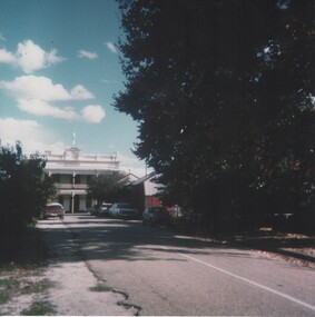
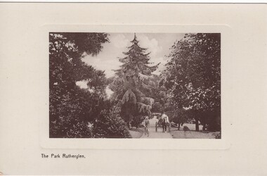 Rutherglen Historical Society
Image, The Park Rutherglen, c1900
A computer screen-print, from the eBay website, advertising this postcard for sale, was found filed with our photographs. Not recognising it as one already held, Martha Valentine purchased the card from eBay and donated it to the collection.Early black and white photograph of Rutherglen Park, printed on a postcard. A horse and cart and a bicyclist are on a path between large trees, with a very large pine tree at the centre of the photograph.At foot of photo: "The Park Rutherglen." On back of card, in the space for a message, is written: "Springhurst, Monday May 15th", and the card is addressed to "Miss Ivy Blackwood, Castella St, Healesville, Victoria"rutherglen park -
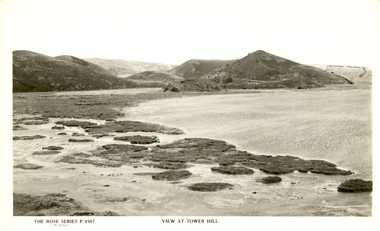 Ballarat Heritage Services
Photograph - Photograph - Black and White, Tower Hill, Victoria
Tower Hill is a volcanic formation believed to have erupted about 32,000 years ago. Its formation is known as a "nested maar" and it is the largest example of its type in Victoria. During formation, molten lava pushed its way up through the Earth’s crust and encountered a layer of water-bearing rock. Violent explosions followed creating a shallow crater which later filled with water to form the lake. Further eruptions occurred in the centre of this crater, creating the islands and cone shaped hills. In 1892 Tower Hill became Victoria’s first National Park. In 1961, Tower Hill became a State Game Reserve under the then Fisheries and Wildlife Department and a major re-vegetation program began. (https://www.towerhill.org.au/index.php/about-reserve/history, accessed 23 December 2019)Black and white photograph of Tower Hill devoid of trees.tower hill, crossley, volcano -
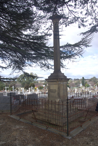 Ballarat Heritage Services
Photograph - Photograph - Colour, Burke and Wills Memorial at Bendigo Cemetery, 2018, 02/09/2018
Robert O'Hara Burke and Thomas Pope Besnard were childhood friends. As sexton of the local Back Creek Cemetery Thomas Besnard organised a subscription to raise the money for a monument to Burke, Wills and Gray. A subscription of one shilling, no more and not less, was asked so all subscribers were equal. The Bendigo monument was designed by Adam Duncan and features a Corinthian column mounted on a foundation stone, topped with a Grecian urn draped with the Union Jack. The stone for the monument was quarried from New Chum Mine. The site in the Bendigo Cemetery was selected by Besnard so the monument was on a grass knoll well clear of any other graves. The design included landscaping with a path and garden beds that provided dignified access. The Burke and Wills Monument in Bendigo has been entered on the Register of the National Estate as being important for its association with historical events and developments associated with exploration in the early days of Colony of Victoria. Two conifers remain from the original group sent by Mueller of the Melbourne Botanical Gardens to develop the garden layout on the knoll. These two trees are listed as Significant Trees by City of Greater Bendigo. The foundation block was laid on 20 August 1862 by Chairman of the Bendigo Municipality, Charles Burrows – exactly two years after the Expedition left Melbourne. A half day holiday was declared by Bendigo Council, and a procession left the Bendigo Town Hall and marched to the cemetery where 8000 people were gathered and another 4000 lined the route. John King was unable to attend due to ill health. Chairman of the Municipality of Bendigo, Charles Burrows, gave a long address, and diaries of members of the expedition, the Sandhurst Almanac, the Bendigo Advertiser, the Bendigo Independent Evening News, photographs of the deceased, photographs of Public Buildings in Bendigo, a Sydney half sovereign and all the silver coins of the Realm were wrapped in a Union Jack and placed in a niche in the foundation stone. Fifteen months later a column was erected on the foundation stone after Besnard openly criticised the Memorial Committee for their lack of action. The Bendigo Advertiser was disappointed at the location of the monument preferring a more central location and in 1893 an attempt was made to move the monument to Rosalind Park. On 19 May 1893, Mr Minto, the City Surveyor of the Bendigo MunicIpality reported it would cost £25, and no other action occurred. In 1940 the land around the memorial was sold off as grave sites and the paths and garden beds disappeared with graves now surrounding the base of the monument. The Burke and Wills Monument in Bendigo Cemetery was entered on the Register of the National Estate for its association with historical events and developments associated with exploration in the early days of Colony of Victoria. Two conifers remain from the original group sent by Mueller of the Melbourne Botanical Gardens to develop the garden layout on the knoll. These two trees are listed as Significant Trees by City of Greater Bendigo.Burke and Wills Memorial at Bendigo Cemetery, 2018Erected by the people of Bendigo in honor of the Victorian Explorers, Burke, Wills, Gray and King who first crossed the continent of Australia. King alone surviving the privation and suffering under which his three brave ill-fated companions sank. A.D. 1862. Robert O'Hara Burke, leader of the Victorian Expedition, left Melbounre 24th August 1860. Reached Carpentaria 12th Feby 1861. Died on his return at Coopers Creek, 30th June 1861. Charles Gray, died also on his return at Polygorum Swamp. 17th April 1861. William John Wills, second in command, died also near Coopers Creek, 29th June 1861. bendigo cemetery, burke and wills, burke and wills memorial, william john wills, john o'hara burke, charles gray, polygonum swamp, coopers creek, victorian expedition, carpentaria, bendigo public cemetery, bendigo remembrance park, thomas pope besnard -
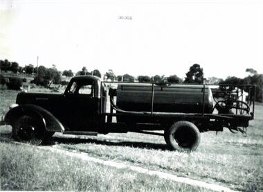 Hume City Civic Collection
Photograph, Water carrier
The Dodge water truck was used in the past by the Sunbury Country Fire members. Country Fire Authority is a volunteer fire fighting organisation attached to many rural towns throughout Victoria and in an important organisation for the state.A black and white scanned photograph with a white border of a fire fighter's water truck. It is parked in a cleared area with a line of trees in the background.water truck, dodge truck, country fire authority -
 Old Colonists' Association of Ballarat Inc.
Photograph - Photograph - Colour, Ballarat Old Colonists' Association Homes, Charles Anderson Grove, Ballarat
HISTORY OF THE BALLARAT OLD COLONISTS' ASSOCIATION HOMES AT CHARLES ANDERSON GROVE, LAKE GARDENS One of the original objectives of the Association was “to provide the shelter of a house for those Pioneers of the Goldfields whom the reverses of fortune have deprived of the means of procuring the comforts of life in their declining years.” While the first home at Charles Anderson Grove was built in 1925 the Association had previously provided relief for needy pioneers from the time it was formed in 1883. Relief included monthly monetary payments, loads of firewood, medical assistance and distribution of Christmas boxes of groceries to deserving pensioners and in some cases payment of burial costs. Records indicate that in September 1922 three of the pensioners being assisted by the Association were accepted as residents in the newly erected Hassell Homes in Gillies Street (now demolished-opposite the High School). The first site for an Asylum for Indigent Members of the Old Colonists' Association was temporarily reserved from sale in October 1891. The site was approximately 28 acres in area in Mt Clear nearly opposite Midvale Shopping Centre in Main Road. The site was heavily timbered and when cleared over 260 tons of wood was sold to the Woah Hawp Gold Mining Company. A set of gates were erected but no homes built, although a plan for this reserve was drawn which showed twenty buildings ranging from one to four unit per building. The reserve was revoked in November 1909. The second site temporarily reserved in November 1909 as an Asylum was in Alfredton and consisted of some 7 acres and was adjacent to land reserved for an Abattoirs for the Ballarat Council. The reserve was revoked in February 1912 as it was deemed more appropriate to be added to the Abattoir site. Council suggested four (4) other sites in exchange for this land and they were inspected by the President, Vice President and Secretary on 22 December 1912. The first site inspected was land on the west side of Creswick Road opposite the brick kilns (now occupied by the showgrounds and oval). The land was described as being good quality, well fenced, no trees, good drainage and ample acreage but some distance from trams. The second site was Perry Park which was described as being good land, well fenced, having frontage to Gillies Street, good drainage and about 26 acres (but subsequently reduced to 10 acres). It was closely planted with Pinus Insignias and Wattle and had easy access from the Botanic Gardens tram. The third site was the North West portion of Victoria Park (corner of Sturt and Gillies Street) and was described as good land, well fenced and drained and well located. The fourth site was the South West corner of Victoria Park and known as Pound Paddock (corner of Winter Street and Gillies Street). It was considered to be low lying and too close to the Abattoir, and was also a considerable distance from trams. While the third site was recommended as the most suitable for the erection of homes it was considered unwise from the point of view as citizens to reduce the acreage of the park and therefore it was recommended that the Perry Park site be asked for as the most acceptable to the Association for the building of homes. The site was eventually temporarily reserved for an Asylum for Indigent Members of the Association in April 1914 with the gates from Mt Clear having been removed to the site a year earlier and eventually erected in 1917 for £12.10.0. In the same year the first 290 pine trees were advertised for removal in July and sold for £16. A sign indicating that the site was reserved for the erection of cottages was erected in September 1917. Stripping of the wattle bark (for tanning) and the cutting of the wood occurred in November 1918 with the land then being leased until it was required for the construction of the first homes in 1924. While the site was the third to be reserved it was the only one which was used for its intended purpose. It was named as Charles Anderson Grove in honour of Charles Anderson who joined the Association in 1918 and was President of the Association from 1942 to 1944. A number of cottages in the Ballarat Old Colonists' Association Retirement Village of Gillies Street, Ballarat.charles anderson grove, old colonists' club, ballarat, old colonists' association, old colonists' homes, retirement village -
 Old Colonists' Association of Ballarat Inc.
Photograph - Image, The History of Charles Anderson and Charles Anderson Grove, Ballarat
Information relating to Charles Anderson and Charles Anderson Grove, Lake Gardens, Ballarat. The Old Colonists' Association Ballarat Inc. is a not for profit charitable organisation providing accommodation for elderly people. It manages a 27 Home retirement village at Charles Anderson Grove, Ballarat. Accommodation is offered at significantly below market rates. It has been providing low cost accommodation to the elderly since the 1920s. The Association Council overseas the running of this facility on a voluntary basis. HISTORY OF THE BALLARAT OLD COLONISTS' ASSOCIATION HOMES AT CHARLES ANDERSON GROVE, LAKE GARDENS One of the original objectives of the Association was “to provide the shelter of a house for those Pioneers of the Goldfields whom the reverses of fortune have deprived of the means of procuring the comforts of life in their declining years.” While the first home at Charles Anderson Grove was built in 1925 the Association had previously provided relief for needy pioneers from the time it was formed in 1883. Relief included monthly monetary payments, loads of firewood, medical assistance and distribution of Christmas boxes of groceries to deserving pensioners and in some cases payment of burial costs. Records indicate that in September 1922 three of the pensioners being assisted by the Association were accepted as residents in the newly erected Hassell Homes in Gillies Street (now demolished-opposite the High School). The first site for an Asylum for Indigent Members of the Old Colonists' Association was temporarily reserved from sale in October 1891. The site was approximately 28 acres in area in Mt Clear nearly opposite Midvale Shopping Centre in Main Road. The site was heavily timbered and when cleared over 260 tons of wood was sold to the Woah Hawp Gold Mining Company. A set of gates were erected but no homes built, although a plan for this reserve was drawn which showed twenty buildings ranging from one to four unit per building. The reserve was revoked in November 1909. The second site temporarily reserved in November 1909 as an Asylum was in Alfredton and consisted of some 7 acres and was adjacent to land reserved for an Abattoirs for the Ballarat Council. The reserve was revoked in February 1912 as it was deemed more appropriate to be added to the Abattoir site. Council suggested four (4) other sites in exchange for this land and they were inspected by the President, Vice President and Secretary on 22 December 1912. The first site inspected was land on the west side of Creswick Road opposite the brick kilns (now occupied by the showgrounds and oval). The land was described as being good quality, well fenced, no trees, good drainage and ample acreage but some distance from trams. The second site was Perry Park which was described as being good land, well fenced, having frontage to Gillies Street, good drainage and about 26 acres (but subsequently reduced to 10 acres). It was closely planted with Pinus Insignias and Wattle and had easy access from the Botanic Gardens tram. The third site was the North West portion of Victoria Park (corner of Sturt and Gillies Street) and was described as good land, well fenced and drained and well located. The fourth site was the South West corner of Victoria Park and known as Pound Paddock (corner of Winter Street and Gillies Street). It was considered to be low lying and too close to the Abattoir, and was also a considerable distance from trams. While the third site was recommended as the most suitable for the erection of homes it was considered unwise from the point of view as citizens to reduce the acreage of the park and therefore it was recommended that the Perry Park site be asked for as the most acceptable to the Association for the building of homes. The site was eventually temporarily reserved for an Asylum for Indigent Members of the Association in April 1914 with the gates from Mt Clear having been removed to the site a year earlier and eventually erected in 1917 for £12.10.0. In the same year the first 290 pine trees were advertised for removal in July and sold for £16. A sign indicating that the site was reserved for the erection of cottages was erected in September 1917. Stripping of the wattle bark (for tanning) and the cutting of the wood occurred in November 1918 with the land then being leased until it was required for the construction of the first homes in 1924. While the site was the third to be reserved it was the only one which was used for its intended purpose. It was named as Charles Anderson Grove in honour of Charles Anderson who joined the Association in 1918 and was President of the Association from 1942 to 1944. CHARLES HENRY GRATTAN ANDERSON C.H.G. Anderson (Electoral Returning Officer) was elected to membership of the Old Colonists' Association, Ballarat, in October 1918. He was elected to the Association Committee in 1926, and appointed Treasurer of the Association on the resignation of F. Ellis until the end of the financial year in 1933. In 1936 Charles Anderson indicated he would not be available for the President's Chair and that he would retire from the Committee owing to pressure of work. C.H.G. Anderson was welcomed as a new member of the Association in 1938, and served as President of the Old Colonists' Association from 1942-1944. Midway through 1949 Charles Anderson was appointed Members Secretary and Manager of the Ballarat Old Colonists' Club at £5.0.0 per week and 10/- for entertainment, to commence work prior to 01 August 1949. He was to do 30 hours per week and be present on Friday and generally on Saturday nights. In 1957 a minute of sympathy was extended to Club Manager Charles Anderson on the loss of his son. In 1958 a bonus of £20.0.0 was paid to Charles Anderson in recognition of his service in assisting the Secretary/Manager taking over under difficult conditions. In March 1964 the Shire of Ballarat would not permit a private road to be named Anderson Grove as Anderson Street already existed in Ballarat but Charles Anderson Grove was deemed acceptable. A recommendation of the Committee was put to the AGM in 1967 that Charles Anderson be made a Life Member. In 1969 an Association meeting observed a minutes silence in memory of Chas Anderson. Charles Anderson was also a Committee member of Ballarat Mechanics' Institute from February 1940 to February 1970. He was President in 1948. Black and white photographic portrait of Charles Anderson.charles anderson, charles anderson grove, ballarat old colonists' club, old colonists' association, ballarat, ballarat mechanics' institute, hassell homes, woah hawp gold mining company, firewood, retirement village -
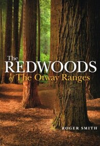 Otway Districts Historical Society
Book, Lothian Custom Publishing, The redwoods of the Otway Ranges. Roger Smith, January 2015
This book is the remarkable story of the world's tallest tree species, the Redwood, growing in the Great Otway National Park in Victoria's south-west. It was originally planted by Victorian foresters for experimental purposes on land abandoned by the early settlers. The Coast Redwood, native of California, is now thrives in the Otways alongside the famous eucalypt, the towering Mountain Ash. The majestic Otway Redwoods, still in their youthful growth phase, have withstood adversity caused by fire, landslide, lighting and chainsaws, while the ongoing political debate about the conservation of the valuable forest resources continues.The redwoods of the Otway Ranges. Roger B. Smith. Lothian Custom Publishing; Middle Park (Vic); 2015. ii, 202 p.; illus., maps, appendices, notes. IBSN 978 1 921737 13 8. Soft cover.With best wishes from Roger Smith. -
Kew Historical Society Inc
Archive (Sub-series) - Subject File, Kew Historical Society, Gardens (Kew), 1979
... 1845-6 on the Willsmere Farm, red gums in Victoria Park, pine... gums in Victoria Park, pine trees in the Cemetery dating from ...Various partiesReference, Research, InformationSecondary Values (KHS Imposed Order)Correspondence and newspaper articles/clippings relating to historic gardens in Kew. The oldest item is a letter from the National Trust Victoria announcing their two-year garden study and seeking information on gardens in Kew. Mavis Rolley, Secretary of the Society, made handwritten notes in response, which are kept in the file. She refers to: the pear trees planted by William Oswin in c. 1845 near what is now the Burke Road Bridge (she notes that a search for the trees at the time of the construction of the Eastern Freeway was unsuccessful), a camellia planted by the Dannocks near the corner of Derby and High Street, a c.1876 pine tree in Field Place, Henty Court, an 1875 Moreton Bay fig at Tarring, Ruyton, a Moreton Bay fig at Roxeth, Trinity Grammar, an 1840s oak tree and a 120-year old olive tree at Fairholme, Barry Street, 1870 pine trees at D’Estaville, Barry Street, trees at Turinville, Barnard Grove, dating to 1846, pine trees dating from 1845-6 on the Willsmere Farm, red gums in Victoria Park, pine trees in the Cemetery dating from the 1860s, trees in the Alexandra Gardens and at Kew Primary School, palm trees at La Verna, Sackville Street dating from the 1890s, the trees and gardens at Ross House (Charleville), and the trees at Merridale, Sackville Street which date from the 1880s, a magnolia at Lalla Rookh. These dates are probably highly contestable. Other handwritten notes from 1979 about significant gardens included: 5 Molesworth Street, Red Bluff - Redmond Street (garden now destroyed), Campion House, Studley Park Road, Raheen, Studley Park Road, Ross House, Cotham Road (Charleville), 7 Adeney Avenue, 20-21 Belmont Avenue, 52 Mary Street, an Edna Walling garden on the corner of Argyle Road and Victor Avenue, Merridale, Sackville Street, Roseneath, and Reno, St John’s Parade.gardens - private - kew (vic), garden design - kew (vic), kew horticultural societygardens - private - kew (vic), garden design - kew (vic), kew horticultural society -
 Kew Historical Society Inc
Photograph, J F C Farquhar, A View in Studley Park Road, 1891
At the beginning of the 1890s, the Kew businessman and Town Councillor, Henry Kellett, commissioned J.F.C. Farquhar to photograph scenes of Kew. These scenes included panoramas as well as pastoral scenes. The resulting set of twelve photographs was assembled in an album, Kew Where We Live, from which customers could select images for purchase.The preamble to the album describes that the photographs used the ‘argentic bromide’ process, now more commonly known as the gelatine silver process. This form of dry plate photography allowed for the negatives to be kept for weeks before processing, hence its value in landscape photography. The resulting images were considered to be finely grained and everlasting. Evidence of the success of Henry Kellett’s venture can be seen today, in that some of the photographs are held in national collections.It is believed that the Kew Historical Society’s copy of the Kellett album is unique and that the photographs in the book were the first copies taken from the original plates. It is the first and most important series of images produced about Kew. The individual images have proved essential in identifying buildings and places of heritage value in the district.This is the earliest known photograph of the exterior of Byram (later Tara Hall). It shows the original red brick fence, its asymmetrical gate and gateposts, with a large terra cotta gargoyle surmounting the higher of the two. The architect, Edward Kilburn designed Byram in the Arts & Crafts style for the industrialist George Ramsden. Construction began in 1888 and was reputed to have lasted three years. The mansion had frontages to Studley Park Road and Stevenson Street, including gardens laid out with great taste, including pleasure grounds, tennis lawn, fruit and flower garden, and paddock. The size of many of the trees in the garden indicate that many survived from the garden of Clifton Villa, the previous single-storeyed house built on the site by the Stevenson brothers. Byram had views to Melbourne and Port Phillip Bay. The house was demolished in 1960, despite opposition from the National Trust (Victoria), and its gardens subdivided into residential allotments.A View in Studley Park Roadkew illustrated, kew where we live, photographic books, henry kellett, byram, tara hall, goathlands -
Kew Historical Society Inc
Journal, Kewriosity : October 1984
[Kew] Recreation Centre update [The Committee; Resident Attitude Survey] / p1. [Anglican] Archbishop's first visit to East Kew [St Paul's Church] / p1. Community [Asian Evangelical Fellowship; Hyde Park Fellowship; Kew Baptist Church; Kew Native Plant Group; Kew Garden Club; Kew (Daytime) Garden Club; Fashion Parade; The Rheumatism and Arthritis Foundation of Victoria; Retiring?; Anyone for tennis?; Games evening] / p2. Council - Mayoral Column / Cr Robin Saunders / p3. New Depot / p3. Library News / p3. Calling on people with disabilities in Kew / p3. Dieback in Kew's Plane Trees / p3. Kew's new Councillors - Roger Streeton; Chester Keon-Cohen] / p4. Kew Junction Shopping Centre - Liftout Guide / p5-6, 11-12. Youth Pages - Welcome / p7. Earth Club Camps / Phil Smith p7. Training the oldies / Elizabeth Trapani p7. Holiday fun around Kew / p8&9. Things to do in Kew / p10. A bit further afield / p10. Community - Artisst take dance , drama & art to the streets / p13. Asthma Foundation / p13. Council - More thoughts about the Community House / p14. 1985 Kew Festival / p14. Development Plan for Lower Yarra / p15. Jackie Kookaburra goes to Sea / p15. Migrant woman candidate for Kew [Anna-Maria Dierer, ALP] / p15. Council/Community - Traffic Management; New Residents' Kit; Family Fun Day [East Kew Uniting Church]; Older Person's Action Centre; Kew Citizens' Band - Engagement list / p16.Kewriosity was a local newsletter combining Kew Council and community news. It was published between November 1983 and June 1994, replacing an earlier Kewriosity [broad] Sheet (1979-84). In producing Kewriosity, Council aimed to provide a range of interesting and informative articles covering its deliberations and decision making, together with items of general interest and importance to the Kew community and information not generally available through daily media outlets.non-fiction[Kew] Recreation Centre update [The Committee; Resident Attitude Survey] / p1. [Anglican] Archbishop's first visit to East Kew [St Paul's Church] / p1. Community [Asian Evangelical Fellowship; Hyde Park Fellowship; Kew Baptist Church; Kew Native Plant Group; Kew Garden Club; Kew (Daytime) Garden Club; Fashion Parade; The Rheumatism and Arthritis Foundation of Victoria; Retiring?; Anyone for tennis?; Games evening] / p2. Council - Mayoral Column / Cr Robin Saunders / p3. New Depot / p3. Library News / p3. Calling on people with disabilities in Kew / p3. Dieback in Kew's Plane Trees / p3. Kew's new Councillors - Roger Streeton; Chester Keon-Cohen] / p4. Kew Junction Shopping Centre - Liftout Guide / p5-6, 11-12. Youth Pages - Welcome / p7. Earth Club Camps / Phil Smith p7. Training the oldies / Elizabeth Trapani p7. Holiday fun around Kew / p8&9. Things to do in Kew / p10. A bit further afield / p10. Community - Artisst take dance , drama & art to the streets / p13. Asthma Foundation / p13. Council - More thoughts about the Community House / p14. 1985 Kew Festival / p14. Development Plan for Lower Yarra / p15. Jackie Kookaburra goes to Sea / p15. Migrant woman candidate for Kew [Anna-Maria Dierer, ALP] / p15. Council/Community - Traffic Management; New Residents' Kit; Family Fun Day [East Kew Uniting Church]; Older Person's Action Centre; Kew Citizens' Band - Engagement list / p16. publications -- city of kew (vic.), kewriosity, council newsletters, community newsletters -
![Giant Red Gum. Victoria Park [Kew]](/media/collectors/550653872162f11fb04854aa/items/658f5e1a101c4283c6ae8194/item-media/658f5e76101c4283c6ae8404/item-fit-380x285.jpg) Kew Historical Society Inc
Kew Historical Society IncPhotograph - Giant Red Gum. Victoria Park [Kew], c.1950
In 1871, Victoria Park, beside the Boroondara General Cemetery was set aside as a public reserve. As the Park developed, exotic plants were added to existing specimens. In 1910, a photograph of ‘The Oldest Inhabitant: A Giant Red-gum Tree’ in the Park was included in the Jubilee History of Kew. Fifty-one years later the tree was re-photographed by Colin Campbell. A 2007 Master Plan developed for the City of Boroondara advises the retention of this now dead River Red Gum, including a ‘managed risk zone’ and planting under the heavily lopped tree.This work forms part of the collection assembled by the historian Dorothy Rogers (1905-1973), donated to the Kew Historical Society by her son in 2015. The manuscripts, photographs, maps, and documents were sourced by her from both family and local collections or produced as references for her print publications. Many were directly used by Rogers in writing ‘Lovely Old Homes of Kew’ (1961) and 'A History of Kew' (1973), or the numerous articles on local history that she produced for suburban newspapers. Most of the photographs in the collection include detailed annotations in her hand. The Rogers Collection provides a comprehensive insight into the working habits of a historian from the 1960s to the 1970s. Small monochrome snapshot of the former giant River Red Gum that until it died was a major feature of Victoria Park, Kew. In the background is the red brick wall of the Boroondara General (Kew) Cemetery.Annotation verso: "Giant Red Gum. Victoria Park. Still there over 100 yrs old"dorothy rogers, victoria park (kew), river red gums -
 Kew Historical Society Inc
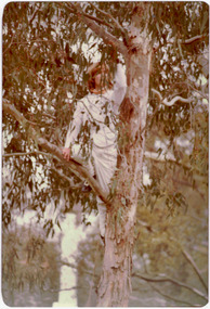
Photograph - Historic re-enactment during the Festival of Kew, 1978
At the 1978 Festival of Kew, a number of organisations, including the City of Kew, the Kew Historical Society, Trinity Boys Grammar School and local Girl Guides participated in a re-enactment of the expedition of the party of Charles Grimes in surveying the Yarra River as far as Kew in February 1803. The location for the event was Yarra Bend Park near the Studley Park Boat House. The event was organised by the Kew Historical Society. The re-enactment was captured by a number of amateur photographers as well as by a photographer from the local Progress Press.Local communities select events to commemorate according to their shared history and values. Commemorations of colonial exploration were popular with local historical groups such as the Kew Historical Society in the twentieth century. In re-enacting events such as the Grimes survey of the Yarra, students from a local school were encouraged to take on specific roles, including play-acting individuals involved in the survey party as well as members of the local Wurundjeri People. The photographs, taken by amateur and professional photographers, represent a period in time when the dominant values were those shared by the descendants of European settlers in Victoria. Original colour photographic positive showing a boy from Trinity Grammar School in a tree, role-playing Captain Robbins, a member of Grimes' survey party.Annotated on reverse: "CAPTAIN ROBBINS LOOKING UP THE YARRA AND REPORTING: 'A LAND THAT OFFERS GREAT OPPORTUNITY FOR SETTLEMENT' / RE-ENACTED BY A TRINITY BOY / 1978 FESTIVAL"kew historical society, trinity grammar school, kew girl guides, city of kew, yarra river, charles grimes, collins expedition, wurundjeri people, yarra bend park, colonial surveys, historic re-enactments, festival of kew, kew festival -
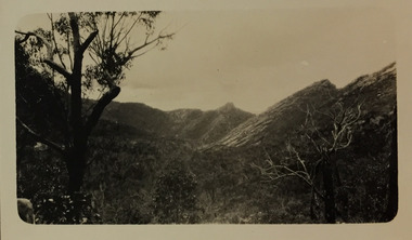 Kew Historical Society Inc
Photograph - Grampians, 1924
Henry Beater Christian (1886-1962) , was a descendant of one of the earliest settler families in Kew. Employed at the Kew Asylum as a 'public servant', he was a skilled amateur photographer, photographing numerous scenes in Kew and on his travels around Victoria. The majority of his photographs date from 1916 to 1929. His finest photographs are housed in two photograph albums. Digital copy of a photograph from page 15 of the 47-page photograph album containing 261 gelatinous silver images, loaned by Diane Washfold with permission given to digitise and hold a copy in our collection. The first and last pages in the album document the Yarra River at Studley Park and at Kew. The remainder of the album includes photographs of walking and car tours in rural Victoria including 'wilderness' areas in the Grampians, Gippsland and the High Country. Six album pages document a camping trip by Henry Christian to the Grampians in September 1924. The photos include pictures of lookouts, and natural features including rock faces and waterfalls, as well as his camp site. This photo is a long distance view of the mountains with trees framing the picture in the foreground. "Grampians"henry beater christian (1886-1962), landscape photography, christian-washfold collection, photograph albums, grampians, mt victory, gariwerd -
![The Bend of the Yarra at Studley Park / [by] Nicholas Caire, circa 1876](/media/collectors/550653872162f11fb04854aa/items/5783120ed0cdd1176c47d8c8/item-media/57831278d0cdd1176c4805d6/item-fit-380x285.jpg) Kew Historical Society Inc
Kew Historical Society IncPhotograph, Anglo-Australasian Photographic Company, The Bend of the Yarra at Studley Park, c. 1876
Nicholas Caire was born on Guernsey in the Channel Islands in 1837. He arrived in Adelaide with his parents in about 1860. In 1867, following photographic journeys in Gippsland, he opened a studio in Adelaide. From 1870 to 1876 he lived and worked in Talbot in Central Victoria. In 1876 he purchased T. F. Chuck's studios in the Royal Arcade Melbourne. In 1885, following the introduction of dry plate photography, he began a series of landscape series, which were commercially successful. As a photographer, he travelled extensively through Victoria, photographing places few of his contemporaries had previously seen. He died in 1918. Reference: Jack Cato, 'Caire, Nicholas John (1837–1918)', Australian Dictionary of Biography.An original, rare photograph from the series 'Views of Victoria: General Series' by the photographer, Nicholas Caire (1837-1918). The series of 60 photographs that comprise the series was issued c. 1876 and reinforced a neo-Romantic view of the Australian landscape to which a growing nationalist movement would respond. Nicholas Caire was active as a photographer in Australia from 1858 until his death in 1918. His vision of the Australian bush and pioneer life had a counterpart in the works of Henry Lawson and other nationalist poets, authors and painters.‘The Bend of the Yarra at Studley Park’ : Views of Victoria (General Series) No.49 : Albumen silver photograph | Photo on card with Title and Description on reverse | Mounted 24 x 30 cm; Photo 12 x 17 cm.On Reverse: The subject of the present illustration is taken from near the Kew Road, on the Park-hill side of the Yarra. The curve of the River at this and other parts of the Park represents a gigantic letter S. It is a remarkable fact that the hilly side of the River is covered with a mass of foliage of various descriptions, from the stately gum tree to the stunted wattle, whilst the opposite side of flat country has scarcely a shrub to be seen any where.’nicholas caire (1837-1918), studley park, yarra river, kew, landscape photography - victoria -
 Kew Historical Society Inc
Photograph, 'Goathland', The Residence of Sir Malcolm D McEacharn, 1901-1911
The architect, Edward Kilburn designed Byram in the Arts & Crafts style for the industrialist George Ramsden. Construction began in 1888 and was reputed to have lasted three years. The mansion had frontages to Studley Park Road and Stevenson Street, including gardens laid out with great taste, including pleasure grounds, tennis lawn, fruit and flower garden, and paddock.The size of many of the trees in the garden indicate that many survived from the garden of Clifton Villa, the previous single-storeyed house built on the site by the Stevenson brothers. Byram had views to Melbourne and Port Phillip Bay. The house was demolished in 1960, despite opposition from the National Trust (Victoria), and its gardens subdivided into residential allotments.An early photograph of Goathland (also known as Byram, Lowan and Tara Hall). The photo shows the front of the building during the period of Sir Malcolm McEacharn’s occupation of the house (1901-11). Edward George Kilburn, of Ellerker & Kilburn, had originally designed the house for the industrialist George Ramsden in 1888. When Sir Malcolm McEacharn purchased Byram, he was to rename it as Goathland. This has led to some confusion, as Goathland was also the name used for McEacharn’s other home in St. Kilda. The period of McEacharn’s ownership represented the high point of the mansion’s history. 'Lost Glories: a memorial to forgotten Australian buildings' was published by David Latta in 1986. It tells the story of a number of significant Australian buildings that had previously been demolished. A chapter in the book was devoted to Goathland, later known as Tara Hall. To supplement the text, he sourced photographs from a range of suppliers, chiefly the Royal Women's Hospital which had once owned Tara Hall, but had sold it in 1960. This is one of the photographs donated to KHS by the author."'Goathland', The Residence of Sir Malcolm D McEacharn"byram, goathland, tara hall, lowan, studley park road -- kew (vic.), melbourne mansions, e g kilburn - architect -
 Kew Historical Society Inc
Photograph - Gates, Victoria Park, 1988
The Kew Asylum Entrance Gateway and an adjacent gate lodge were built at the Princess Street entrance in 1873.1 The imposing sandstone pillars and cast-iron gates impressed upon visitors the therapeutic and civilising vision of the asylum. The entrance opened onto a tree-lined drive (now known as Main Drive) which culminated in an elliptical carriageway in front of the main building. (Heritage Council of Victoria)Colour photographic positive of the former Kew Asylum Gates which were relocated in 1942 to Victoria Park in High Street, Kew. The gates were listed by Heritage Victoria in 2020. The citation reads: "The Former Kew Asylum Entrance Gateway consists of two 4.5 metre sandstone gate piers on bluestone bases on either side of a 5.5 metre vehicle entrance set back from the High Street pavement. The 1870s gate piers are of Barrabool sandstone and repairs during 2015-16 were undertaken with sandstone from English Town, Tasmania. The gate piers are highly decorative and feature oculi, triglyphs, dentils, corbeling and other ornamental work. Each gate pier incorporates a pedestrian archway with a cast-iron pedestrian swing gate. Two curved sections of cast-iron palisade fencing on rusticated bluestone blocks extend from the outer edges of the piers to a set of shorter sandstone pillars on the High Street pavement. Straight sections of cast-iron fence extend 4.5 metres ending at two bluestone pillars. Garden beds have been created within the curved sections of fencing, bordered by concreted bluestone and planted with shrubs." (Heritage Council of Victoria)gates -- kew asylum, gates -- victoria park -- kew (vic.) -
 Glen Eira City Council History and Heritage Collection
Booklet, "AVENUES OF HONOUR The Councils of the Municipalities of the CITY OF CAULFIELD TOWN OF BRIGHTON acting in conjunction PUBLIC DEMONSTRATION SAT 3rd AUG. 1918 AT 3oCLOCK"
Souvenir Programme from the Councils of the Municipalities of the City of Caulfield and the Town of Brighton for a Public Demonstration to be held on Sat 3rd August 1918 at 3 o'clock for the proposed Avenues of Honour to be planted in memory of fallen WWI soldiers. From Honour Roll Display 2019 interpretation panel - Brighton-Caulfield Avenue of Honour It is hard to imagine but a grand arboreal Avenue of Honour once lined parts of North Road, McMillan Street and Point Nepean Road (now Nepean Highway). The Avenue of Honour was a distinctly Australian phenomenon with hundreds being constructed throughout Australia during and following World War One, most of these in Victoria. Consisting of tree lined streets with each tree representing a solider, the Avenue of Honour signalled a more egalitarian approach to commemoration where rank was not a consideration. Arguably the most famous Avenue of Honour in Victoria still exists at Ballarat. Stretching for nearly 22 kilometres, the entrance to the Avenue is marked by the imposing Arch of Victory. Smaller in scale, the Brighton-Caulfield Avenue of Honour was dedicated to the ‘memory of (Brighton and Caulfield’s) kith and kin who came from (the) district and who died in the Great War’. A joint project between the neighbouring Councils, the idea was first reported in The Argus on 1 July 1918. Plans moved along quickly and on 3 August 1918 the Governor of Victoria Arthur Stanley planted the first Australian flowering gum. The next of kin were then invited to plant trees for lost sons, brothers, uncles, nephews and husbands. In all, over 400 trees were planted. Intensely personal, the Avenue also acted as a focus of grief and remembrance for the wider community. For many years, the annual civic Anzac Day service was held at the Avenue on Point Nepean Road, near Glen Huntly Road, Elsternwick. The service was moved to Caulfield Park upon the completion of the Cenotaph in 1930. Due to road widening and disease the last original tree was replaced in the 1980s, however a plaque in Caulfield Park records the Avenue’s plantation. Commemorative booklet, grey cover with text printed on the grey textured paper cover and an image of four trees and a wreath. Image of a kookaburra on the back. Inside, 28 numbered pages with b/w text and photographic images including a transparent paper representation of the proposed Avenues of Honour on Brighton Road and Point Nepean Road. Souvenir programme for a Public Demonstration for the Avenues of Honour as detailed on the front.city of caufield, world war one, first world war, anzac, remembrance, town of brighton, brighton, caulfield, avenue of honour -
 Glen Eira City Council History and Heritage Collection
Booklet, D. W. Paterson Co. Pty. Ltd, "AVENUES OF HONOUR The Councils of the Municipalities of the CITY OF CAULFIELD TOWN OF BRIGHTON acting in conjunction PUBLIC DEMONSTRATION SAT 3rd AUG. 1918 AT 3oCLOCK SOUVENIR"
Souvenir Programme from the Councils of the Municipalities of the City of Caulfield and the Town of Brighton for a Public Demonstration to be held on Sat 3rd August 1918 at 3 o'clock for the proposed Avenues of Honour to be planted in memory of fallen WWI soldiers. One of two known copies, this copy has "Town Clerk" stamped in the upper corner, rhs.Commemorative booklet, grey cover with text printed on the grey textured paper and an image of four trees and a wreath. Image of a kookaburra on the back. Inside, 28 numbered pages with b/w text and photographic images including a transparent paper representation of the proposed Avenues of Honour on Brighton Road and Point Nepean Road. Souvenir programme for a Public Demonstration for the Avenues of Honour as detailed on the front. From Honour Roll Display 2019 interpretation panel - Brighton-Caulfield Avenue of Honour It is hard to imagine but a grand arboreal Avenue of Honour once lined parts of North Road, McMillan Street and Point Nepean Road (now Nepean Highway). The Avenue of Honour was a distinctly Australian phenomenon with hundreds being constructed throughout Australia during and following World War One, most of these in Victoria. Consisting of tree lined streets with each tree representing a solider, the Avenue of Honour signalled a more egalitarian approach to commemoration where rank was not a consideration. Arguably the most famous Avenue of Honour in Victoria still exists at Ballarat. Stretching for nearly 22 kilometres, the entrance to the Avenue is marked by the imposing Arch of Victory. Smaller in scale, the Brighton-Caulfield Avenue of Honour was dedicated to the ‘memory of (Brighton and Caulfield’s) kith and kin who came from (the) district and who died in the Great War’. A joint project between the neighbouring Councils, the idea was first reported in The Argus on 1 July 1918. Plans moved along quickly and on 3 August 1918 the Governor of Victoria Arthur Stanley planted the first Australian flowering gum. The next of kin were then invited to plant trees for lost sons, brothers, uncles, nephews and husbands. In all, over 400 trees were planted. Intensely personal, the Avenue also acted as a focus of grief and remembrance for the wider community. For many years, the annual civic Anzac Day service was held at the Avenue on Point Nepean Road, near Glen Huntly Road, Elsternwick. The service was moved to Caulfield Park upon the completion of the Cenotaph in 1930. Due to road widening and disease the last original tree was replaced in the 1980s, however a plaque in Caulfield Park records the Avenue’s plantation. Inkstamp upper corner rhs: "TOWN CLERK"