Showing 335 items
matching university land
-
 Federation University Historical Collection
Plan, Smythesdale, County of Grenville, 01/12/1892
This plan is associated with former Ballarat School of Mines Student Richard Squire (1875-1876). Gift of the Squire FamilyA plan showing the Borough of Smythesdale, Smythesdale, Browns and Scarsdale, allotments, water reserve, Timber reserve, Nintingbool Pre-emptive Right, Reserve for public gardens, Reserve for Cricket Ground, Reserve for Reservoirsmythesdale, scarsdale, browns, yarrowee, carngham, samuel barlett, sheridan, wrigley, p. land, r. simpson, d. davis, nintingbool, mclachlan, a. mclachlan, c. taylor, w. c. smith, d. davies, w. williams, m. jones, t. mcgurk, r. selkirk, a. mooney -
 Federation University Historical Collection
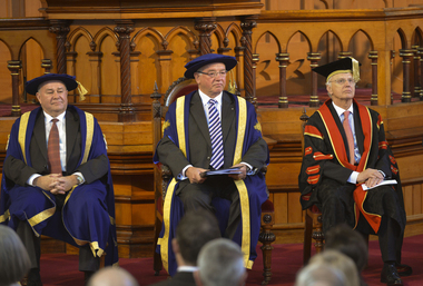
Photograph - Photograph - Colour, Installation of University of Ballarat Chancellor Paul Hemming, 2012, 17/0/2012
In April 2012 former Royal Australian College of General Practitioners president Dr Paul Hemming was appointed the University of Ballarat’s new chancellor. Dr Hemming was a deputy chancellor of the university since 2011 and a member of the university council since 2007, and replaces outgoing chancellor Robert Smith. He was a founding director of Beyondblue and has been president of the Royal Australian College of General Practitioners. He was also president of the Australian Medical Association Victoria and has served on numerous federal government medical bodies and tribunals. Chancellors are appointed to chair the university's council (governing body) as the senior office holder of the University. They also confer the academic awards of the university, and represent the university at meetings, functions and ceremonies. At the installation of Dr Hemming as the Fifth Chancellor Of The University Of Ballarat Governor of Victoria Alex Chrnov said: "I join Bonnie Fagan in acknowledging the traditional owners of this land and I pay my respects to their elders past and present. It is my great pleasure, as Governor of Victoria and Visitor to the University of Ballarat, to install Dr Paul Hemming as the fifth Chancellor of this University. I extend to him and his family my warmest congratulations on this appointment and wish him all the best in his new role. I have no doubt that he will be an industrious and wise leader of this University. Although the University of Ballarat is one of Australia’s newest Universities, it is the third oldest Tertiary institution in our country with the School of Mines being established in 1870. It has much to be proud of, and should be recognised for its commitment to being one of our most outstanding regionally focused higher education institutions. It offers on six campuses a diverse, yet suitably targeted, group of learning models that include higher education, TAFE and senior secondary school education, and is one of the few universities in the country that has an associated Technology Park. This University is uniquely placed to provide higher education in Regional Victoria. For example, I understand that by 2020 the population in the Ballarat area will increase by 20% so this University will have the responsibility and opportunity to provide educational opportunities for this growing population. The role of the Governor can be divided into three parts – ceremonial, constitutional and community engagement. It is the third aspect of the role that is most time consuming and, I add, enjoyable. It includes making official visits to Regional areas of Victoria. To date Elizabeth and I have been on 16 such visits and the thing that stands out is that despite the challenges that face Regional communities whether it be through natural disasters, or the economy more broadly – the stoicism, volunteerism and self reliance are always present. Ballarat is an example of such resilience and confidence in its future that can be dated back to this University’s inception. When the School of Mines was established in 1870 on the back of the gold rush era of the 1850s, the local community had vision and faith in its future that is reflected in the building of this institution. It is not dissimilar to Melbourne, where its relatively few citizens established the iconic pillars of our society like the State Library, the University of Melbourne, Parliament Houses and the National Gallery of Victoria. The contribution by the University of Ballarat to Regional Victoria cannot be overstated. Not only does it provide top educational opportunities for students from the Region but its graduates almost invariably end up working in Regional Australia, and often in their own local communities. More specifically, almost three out of every four of the graduates from this University end up finding employment in Regional areas. Such figures highlight the University’s significant contribution to the Regional economy. But its impact is not limited to our Regional areas – it extends to other parts of Australia and overseas. But like so many other higher education institutions in Australia, the University of Ballarat is facing challenges brought about by events such as global uncertainties and the high Australian dollar that impact on the inflow of international students, and dealing with students, more and more of whom come from the lower socio economic sector. It is in those circumstances that the Chancellor must show leadership that involves, amongst others, objectively guiding the Council and supporting the Vice-Chancellor, albeit without becoming involved in the day to day micro management of the University. A strong, trusting and respectful working relationship between the Chancellor and the Vice-Chancellor is, I believe, critical to the sound progress of a University. Before I turn more specifically to Dr Hemming, I would like to reflect briefly on his immediate predecessor, Emeritus Professor Robert Smith. I am sure that Dr Hemming has already found in Professor Smith an invaluable source of assistance. He was a skilled and effective leader not only here, but also in the broader higher education sector. I mention by way of example his instigation and leadership two years ago of the much acclaimed Chancellors’ Conference that was held in Melbourne. There was great diffidence amongst the Chancellors in having it at all. It was a little like herding cats. But Bob Smith spearheaded the organisation of it, with great attention to detail. And it was his hard work and leadership that resulted in the Conference being such a success and of assistance to all Chancellors who attended. It was an illustration of Bob Smith’s skills as a leader in the sector and of this University. And the sector, just as this University remains indebted to him. And I have no doubt that Dr Hemming will similarly lead this University through the challenging, yet exciting, times that lie ahead. He is eminently qualified to do so, in terms of his personal attributes, academic achievements and experience in governance. With his extensive medical career as a General Practitioner, service on a number of Federal Government medical boards and tribunals, and having been a Founding Director of ‘Beyondblue’, President of the Royal Australian College of General Practitioners and President of the Australian Medical Association (Victoria), his list of personal and professional achievements, as well as his strong sense of public and community duty, is impressive. Importantly, Dr Hemming has a long standing connection with the Ballarat community, having moved here with his family from the United Kingdom in 1977. He is now even accepted as a “local” I am told. Given his range of experience to which I have referred and the time he has already spent on the Council and Standing Committees of this University, he is obviously well placed to take part in leading this University. So it is a great pleasure for me to install Dr Hemming as the fifth Chancellor of the University of Ballarat." (http://www.governor.vic.gov.au/victorias-governor/publications/speeches/speech/speech/104) Colour photographS of three men in academic regalia sitting inside the Ballarat Uniting Church, Lydiard Street South. Chancellor Dr Paul Hemming sit in the centre, with Vice-Chancellor Professor david Battersby on the left. Also audience images, academics and a dinner at Craig's Hotel.university of ballarat, federation university, regalia, chancellor, vice chancellor, paul hemming, david battersby, alex chrnov, todd walker, andy smith, craig's hotel, academics -
 Federation University Historical Collection
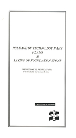
Programme, Release of Technology Park Plans and Laying of Foundation Stone, 1995, 02/1995
The Ballarat Technology Park site consists of 28.8 hectares of freehold land zoned for technology Purposes. The development plan for the Park was prepared by the City of Ballarat. The construction of the ISSC Southern Regional Data Centre was the first stage of the project. ISSC Southern Regional Data centre is a $12.5 million building development at the corner of Geelong Road and gear Avenue. The building was constructed by H. Troon Pty Ltd. White card program for the Release of Technology Park Plans and Laying of Foundation Stone. ballarat technology park, issc southern region data centre, troon, david james, geoffrey blainey, bruce clark, john bligh, roger hallam, campus plan -
 Federation University Historical Collection
Booklet, Education Department Victoria, Victorian Education Department Course of Study of primary Schools: Social Studies, 1954 and 1956
.1) 18 page booklet relating to the Victorian Education Department Course of Study of Primary Schools: Social Studies grades 1 to 6. Topics include family and home, how the community lives and works, Beyond the Neighbourhood (Africa, Canada, New Guinea, India, China, Italy, English factory town), The World About Me (School, home, food, clothes), Our Own Land (The Australia Our Ancestors Found - unknown interior, sheep, riches from underground, water, grain, cows, meat, tropics, tall timbers, manufacture, Melbourne, travel), The Land of Our Fathers (British Descent, From other Countries .2) Victorian Education Department Course of Study of primary Schools: Social Studies, Grades VII and VIII 6 page printed bookleteducation department, social studies, education -
 Federation University Historical Collection
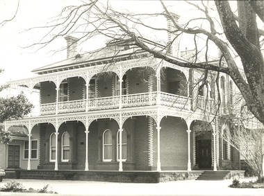
Photograph, Geoff Biddington, Former Cyril Retallick House (Now Australian Catholic University), Ballarat, c1967
In 1881 Cyrus Bath Retallack purchased land now known as 1200 Mair Street Ballarat. Retallack was a successful Cornish miner and engineer. He built a two storey brick mansion between 1882 and 1883, naming the property ‘Carn Brae’ after the castle in Cornwall. Substantial grounds were established with with range of exotic trees planted, a tennis court was laid out and a stables building was erected. In 1918 the site become a campus of Queen’s GIrls’ Grammar School, then Aquinas College which was merged into the Australian Catholic University from 1973. Photograph of a double storey brick building on bluestone foundations, with cast iron balcony. ballarat, geoff biddington, cast iron, bluestone, cyril retallick, australian catholic university, ballarat, aquinas college -
 Federation University Historical Collection
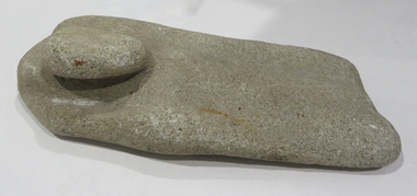
Ethnographic Material, Stone grinding/sharpening tool
Stone grinding/sharpening tool with 'bump' which could be used as a handle. Evidence of wear due to sharpening on both sides of the stone. The rock is calcite cemented quartz sandstone; it is sedimentary quartzite with a granular appearance. It has a soft matrix, and is pale, indicating its calcite nature, as well as dissolved pits. Its origin is from dry land soils and dunes. aboriginal, stone, tool, archaeology, stone tools, sandstone, quartzite, calcite -
 Federation University Historical Collection
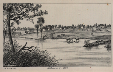
Image, John Helder Wedge, Melbourne in 1838, 1938
The following information is from http://melbourneday.com.au/about.html, accessed 30 August 2016 Melbourne was founded on 30 August 1835 by settlers who sailed from Van Diemen’s Land (Tasmania) aboard the schooner Enterprize. They landed on the north bank of the Yarra River and established the first permanent settlement, close to where the Immigration Museum at the Old Customs House — on the corner of William and Flinders Streets — stands and the place today known as Enterprize Park. Melbourne Day Committee was established to help correct the record about the founding of Melbourne and celebrate its anniversaries. The settlers came from Launceston in search of sheep-grazing land. Land had become expensive and there had long been stories told by whalers and sealers working in Bass Strait of fertile land to the north. This was the southern part of the colony of New South Wales, which the Colonial Government did not want settled at that time. After the Henty family crossed Bass Strait and settled at Portland in 1834 others quickly followed. The north bank was chosen because a small waterfall, or rapids, stopped further progress up the river. The waterfall also separated the tidal movement, providing a vital supply of fresh water. The site had previously been noted by the colony of New South Wales' surveyor, Charles Grimes, in 1803. The north bank also offered more stable, suitable ground. The people of the Kulin nation are the traditional owners of the land that became Melbourne — including the Boonwurrung, Woiwurrung, Taungurung and Djadjawurrung people, who gathered in this place for ceremonies and cultural activities. The topsail schooner Enterprize you see today is a full-size replica of the one that brought the settlers and has become a symbol of Melbourne Day. Her keel was laid at Polly Woodside Maritime Museum in 1991, and the $2.5 million, 27m vessel was launched by Felicity Kennett on 30 August, 1997, at Hobsons Bay. The original ship was bought by John Pascoe Fawkner in April 1835 specifically to search for a suitable place for a settlement in the Port Phillip District. After helping establish Melbourne, the original Enterprize continued operating as a coastal trading vessel for a number of years. She eventually disappeared off the shipping register in 1847, having been wrecked on a sand bar in the Richmond River in northern NSW, with the loss of two lives. The replica is managed by the Enterprize Ship Trust, a not-for-profit organisation. The first settlers were those on board the Enterprize — her crew and passengers. They were John Lancey , master mariner and Fawkner’s representative; Enterprize's captain, Peter Hunter; George Evans, plasterer/builder; carpenters William Jackson and Robert Hay Marr; Evan Evans, George Evans’ servant; and Fawkner’s servants ploughman Charles Wise, general servant Thomas Morgan, blacksmith James Gilbert and his pregnant wife, Mary. And Mary's cat! Enterprize set sail on her historic voyage from Launceston on July 21, 1835, stopping at George Town in northern Tasmania where creditors detained Fawkner. He was therefore not part of the first trip to Melbourne. Enterprize then left on August 1 under the command of captain Hunter. The expedition was led by Lancey, Fawkner's delegate. The party first considered Western Port and the eastern side of Port Phillip for a place to settle, before deciding on the Yarra’s north bank — known today as Enterprize Park. On Sunday, August 30, they disembarked and began to erect shelter, build a store and clear land to grow food, thus starting the permanent European settlement of Melbourne.Image of the fledgling town of Melbourne on the banks of the Yarra River. melbourne, yarra river, john helder wedge -
 Federation University Historical Collection
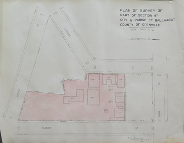
Plan, Plan of Survey of Part of Section 9A City & Parish of Ballarat County of Grenville (Albert Street frontage), 1932
The M.B. John Trade Building was built on the Albert Street Frontage..1) Plan of SMB showing Albert, Grant, Lydiard and Dana streets, on paper with colored highlights undertaken by Ballarat School of Mines student George Murrowood in 1932 .2) Hand written page by George Murrowood, of technical description of land surveying Grade II 1932ballarat school of mines, surveying, george murrowood, albert street, alumni, m.b. john building, architectural plan -
Federation University Historical Collection
Photograph - Black and White, Former Ballarat Library, c1960
First known development on this site was the establishment of the Government Camp from the early 1850s. It was established to accommodate officials, troopers and police who were needed to administer the goldfields. Some permanent buildings were constructed. Lack of materials and bad weather prolonged the building of more permanent buildings and most men were still living in tents. Area was known as Camp Reserve. In 1864 a subdivision map shows the reserve be used for Public Buildings. Library applied for land on corner of Sturt and Camp Streets in 1878. 1880s plans show section of the reserve be used for a Free Library and Reading Room. Lease was granted and the old mining boardroom was initially used. Land for additional building to house a Museum and Art Gallery sought and agreement reached in 1882-3. Compensation paid to owners and library granted the land. Plans for a new library building with tower and lantern roof abandoned due to lack of funds. It wasn't until 1895 that a solution to funding was found and the library was able to begin constructing the complex of buildings on the Free Library Reserve. A number of changes have occurred since 1910s - the Classical Revival facade replaced with an angled facade in a stripped Classical style with Art Deco features and high parapet. Building is now part of Federation UniversityPhotograph of former library. Shows a two-storey rendered brick building in a Classical style. Some Art Deco features. Central pair of double windows with single window either side. High parapet above.government camp, goldfields, camp reserve, free library, reading room, sturt street, camp street, museum, art gallery, troopers, police, barracks, camp street -
 Federation University Historical Collection
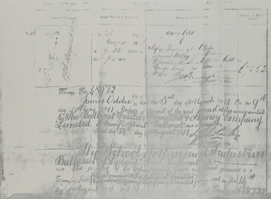
Document, James Oddie Probate Document
James Oddie died on 03 March 1911.Difficult to read thermo copy of a probate document relating to James Oddie's transfer of land to the Ballarat School of Mines.james oddie, ballarat school of mines, probate, land transfer, ballarat trustees, samuel willey -
 Federation University Historical Collection
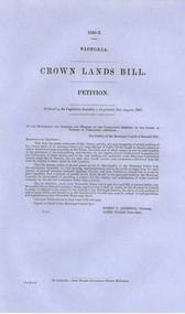
Document, Victorian Crown Lands Bill Petition, 1856-7, 1857
Blue Foolscap printed document relating to a Crown Lands Bill Petition ordered by the Legislative Assembly to be printed on 21 August 1857.crown land, petition, emerald hill, robert anderson, james eville -
Federation University Historical Collection
Poster - Signs, Window signs by Keith Rash
It is thought the signs were used for Ballarat's Gold Centenary in 1851.Seven window signs by Keith Rash painted onto wallpaper. The signs were designed to sit in shop windows to tell the history of the shop of company. .1) In 1862 Eurgene Bourdet conducted the "Imperial Dining Rooms" here. Board 20/- Board & Lodging 25/- week .2) On 16th Feb. 1853 at the Government Land Sale, Mr C.N. Thorne purchased this area. In 1893, R. Ludbrook used this property as Auction Rooms. .3) McArtney & aldred first occupied these premises in 1856. There were coachbuilders. .4) From the Single Storeyed wooden building once her J.P. Clarke operated as a carrier until 1865. Welsh & Surplice took over as Estate Agents until 1870. .5) Dr James Stewart built this property H.G. Harrison, 1957. J.C. Proctor 1862, John Stokes 1865, were chemists here. In 1856 The Savings Bank commenced here. W.H. Pooley, actuary .6) Wm Moss, tinsmith, occupied this site in 1865. Thos. Freeman,a uctioneer in 1882. .7) Doig & Cant. Gasfitters & Plumbers came here from Main Road in 1866. After 38 years A. Cant removed 2 doors further north .8) In 1871, This part was the shop of Wm Moss, tinsmith & plumberballarat, doig, cant, plumber, william moss, tinsmith, thomas freeman, james stewart, h.g. harrison, j.c. proctor, john stokes, savings bank, w.h. pooley, j.p. clarke, welsh, surplice, mcartney, aldred, coachbuilders, c.n. thorne, r. ludbrook, eugene bourdet -
 Federation University Historical Collection
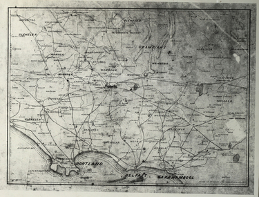
Photograph - Black and White, Map of Western Victoria
WGS 84 37" 47' S 142" 08' EPhotograph of a map showing the Grampians, Glenelg, Portland, Belfast (Port Fairy), Warrnambool, roads and land-holders.western victoria, victoria, belfast, port fairy, warrnambool, manifold -
 Federation University Historical Collection
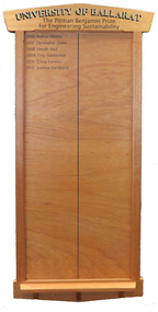
Honour Board, The Pitman Benjamin Prize for Engineering Sustainability Honour Board, c2006
The Pitman Benjamin Prize for Engineering Sustainability is awarded to the Civil Engineering student whose thesis best promotes sustainable engineering. It is awarded in memory of a Heather Pitman, the first woman to graduate in Engineering at Ballarat. The Pitman Benjamin Prize for Engineering Sustainability is sponsored by Benjamin Real Estate, and was first awarded in 2006. Heather was the first female graduate from Ballarat College of Advanced Education and obtained outstanding results. Throughout her career she worked predominantly in local government and for much of that time with the Shire of Ballarat, then the City of Ballarat. During that time she worked as a civil engineer and in planning. Heather was a trail blazer in many respects and was one of the first women to be employed into an engineering position at that time. It was not easy, and she applied for about 200 jobs before being employed by the Shire of Greensborough, north of Melbourne. In 2002 Heather Pitman was Land Development Engineer with the City of Ballarat. The following year she was the City of Ballarat's Manager, Building & Assets. Award sponsor Terry Benjamin was a great mentor of Heather’s sponsoring the award in her memory when she died suddenly at the age of 48. Honour Board, gold lettering University of Ballarat. Black lettering The Pitman Benjamin Prize for Engineering Sustainability. The Pitman Benjamin Prize for Engineering Sustainability has been awarded to: * 2006 - Nathan Whittle; * 2007 - Christopher Quinn; * 2008 - Vinoch Ravi; * 2009 - Troy Vanberkel; * 2010 - Nil; * 2011 - Craig Furniss; * 2012 - Joshua Handreck; * 2013 - Matthew Willis (not on board 10/6/2014); * 2013 - Daniel Camilleri (not on board 10/6/2014);pitman benjamin, nathan whittle, christopher quinn, vinodh ravi, troy vanberkel, craig furniss, joshua handreck, prize, engineering, sustainability, heather pitman, stuart benjamin, benjamin real estate -
 Federation University Historical Collection
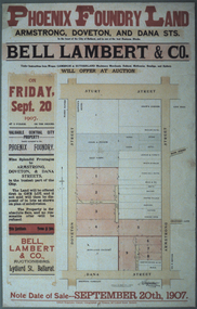
Photograph - Colour, Photograph of the Phoenix Foundry Land Sale Poster, 1907, 1907
Photograph of a poster advertising the auction of Phoenix Foundry Land located on the corner of Armstrong, Doveton and Dana Streets in Ballarat held on 20 September 1907 by Bell, Lambert and Co., auctioneers of Lydiard Street, Ballarat.phoenix foundry, ballarat, newton's hotel, coles and pullum, sale yards, snow's corner, bazaar hotel, stork hotel, jordon and tippett, reid's stables, town hall hotel, mead and co, smith, mather, gazzard, coffee palace, whykes, dimond building, rowland's factory, hunter, hunter daniel & co, ballarat brewing company, tulloch, armstrong street south, doveton street south, dana street -
 Federation University Historical Collection
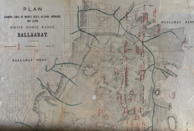
Plan, White Horse Range Ballarat, 1885, 06/1885
Two plans .1) Plan of the Ballarat Goldfields showing leads, rivers, streets and topography. Quartz reefs include: Yorkshire, Try Again, Promised Land, Western Slates, Norwegian, Robert's Lode, Finn's, Band and albion, Rothschild, Old Post Office, Queen Lode. Leads include: Navy jacks, Gays, Canadian, Prince Regent, Sailors Gully, White Horse, Little White Horse, Milkmans, Nightingale, Golden Point, Gravel Pits. Scale is 8 Chains to 1 inch .2) Plan showing lines of quartz reefs, alluvial workings and leads, White Horse Range, Ballarat. Leads include White Horse LEad, Little White Horse Lead, One Eye Gully, Terrible Lead, Sailor's Gully, Canadian Lead, Prince Regent Gully, Canadian Lead, Cavs Lead, Navy jacks Lead, Eureka Lead, Old Gravel Pits Lead, Gravel Pits Lead, Nightingale Lead, Malakoff Lead, Milkmans Lead, Redan Lead, Woolshed Lead, Jacksons Lead, Winters Lead, SCtochman's Lead, Canadian Lead. Reefs include: Promised Land, Daniash, Sir Garnet Wolsley, Norwegian, Rothschile, Band and Albion, Finns, Llanberis, Roberts Lode, Tynworths and Black Hill, Oregan, Yorkshire, Try Again, Yorkshire, Post Office, Clarke's, Western Slates, Black Slate, Danks Slates, Eastern Slates, Queen's Lode, Fire Brigade. Mines include Red Streak, New Chum, Tinworths, Woah Hawp, Normanby, Speedwell, Llanberris Extended, Llanberis, Last Chance, Major, Countess, Pioneer and a number of batteries along Main Road Hills include: Mount Clear, Pennyweight Hill, Sovereign Hillballarat, plan, white horse range, white horse, goldfields, mines, reefs, indicators, leigh river, cgt, tinworth, mining -
 Federation University Historical Collection
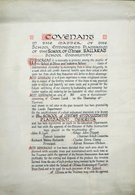
Certificate, Ballarat School of Mines Endowment Plantation, Nerrina Covenant, c1958, c1958
Throughout the Nerrina district numerous areas of public land were set aside as school endowment plantations as part of various schools’ educational resources. The plantations were initially established to instil through community involvement a love of forests and an appreciation of their value, and in fact many of them are well suited for regular use as a teaching resource of this nature. It was expected that this use will increase as courses embracing various aspects of environmental science are developed. Many school plantations have been planted to radiata pine, and revenue from the sale of produce used to provide amenities required by the schools. In some cases, however, these plantations have not been very successful in providing revenue, as the sites are unsuitable for economic growth or the plantations are too small or the location too far from processing centres to allow economic harvesting. In some instances, radiata pine plantations have failed due to poor management. In 1982 the Land Conservation Council believed that all the existing plantations should be assessed in order to establish their value as a teaching resource. Those not needed or that are unsuitable for teaching purposes for some reason, such as their location, should be terminated. Those planted to radiata pine that have limited value as a teaching resource although satisfactory for wood production may continue to be used for such production, but should be reviewed when the pines are harvested. (http://www.veac.vic.gov.au/reports/354-Ballarat-Study-Area.pdf, acccessed 30/03/2017) The School Endowment Plantation Scheme was established in 1922 as a joint venture between the Education Department and the FCV. It was administered by the Education Department with technical supervision by the Commission. While some plantations were established on private land donated or leased for the purpose, most were established on Crown Lands or Reserved Forest made available, without cost, by the State. (https://www.victoriasforestryheritage.org.au/community/schools.html, accessed 26 September 2020)Covenant in the matter of the School Endowment Plantation of the School of Mines Ballarat School Community.nerrina pine plantation, ballarat school of mines endowment plantation, nerrina, pine plantation, nerrina, john r. lyall, richard w. richards, dick richards, edgar j. tippett, charles h. clamp, alfred k. mcbain, endowment plantation -
 Federation University Historical Collection
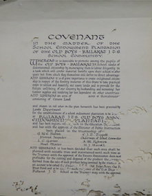
Certificate, Ballarat Junior Technical School Old Boys Association Endowment Plantation, c1928, c1928
The School Endowment Plantation Scheme was established in 1922 as a joint venture between the Education Department and the FCV. It was administered by the Education Department with technical supervision by the Commission. While some plantations were established on private land donated or leased for the purpose, most were established on Crown Lands or Reserved Forest made available, without cost, by the State. (https://www.victoriasforestryheritage.org.au/community/schools.html, accessed 26 September 2020) Throughout the Nerrina district numerous areas of public land were set aside as school endowment plantations as part of various schools’ educational resources. The plantations were initially established to instil through community involvement a love of forests and an appreciation of their value, and in fact many of them are well suited for regular use as a teaching resource of this nature. It was expected that this use will increase as courses embracing various aspects of environmental science are developed. Many school plantations have been planted to radiata pine, and revenue from the sale of produce used to provide amenities required by the schools. In some cases, however, these plantations have not been very successful in providing revenue, as the sites are unsuitable for economic growth or the plantations are too small or the location too far from processing centres to allow economic harvesting. In some instances, radiata pine plantations have failed due to poor management. In 1982 the Land Conservation Council believed that all the existing plantations should be assessed in order to establish their value as a teaching resource. Those not needed or that are unsuitable for teaching purposes for some reason, such as their location, should be terminated. Those planted to radiata pine that have limited value as a teaching resource although satisfactory for wood production may continue to be used for such production, but should be reviewed when the pines are harvested. (http://www.veac.vic.gov.au/reports/354-Ballarat-Study-Area.pdf, acccessed 30/03/2017)Covenant in the matter of the School Endowment Plantation of the Ballarat Junior Technical School Old Boys Association Endowment Plantation.pine plantation, alfred k. mcbain, g.w.e. pearson, i.c. garner, a.m. robinson, h.j. hassell, ballarat junior technical school old boys association endowment plantation, ballarat junior technical school, alumni -
 Federation University Historical Collection
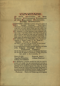
Certificate, Ballarat Technical School Endowment Plantation, 1928, 1928
The School Endowment Plantation Scheme was established in 1922 as a joint venture between the Education Department and the FCV. It was administered by the Education Department with technical supervision by the Commission. While some plantations were established on private land donated or leased for the purpose, most were established on Crown Lands or Reserved Forest made available, without cost, by the State. (https://www.victoriasforestryheritage.org.au/community/schools.html, accessed 26 September 2020) Throughout the Nerrina district numerous areas of public land were set aside as school endowment plantations as part of various schools’ educational resources. The plantations were initially established to instil through community involvement a love of forests and an appreciation of their value, and in fact many of them are well suited for regular use as a teaching resource of this nature. It was expected that this use will increase as courses embracing various aspects of environmental science are developed. Many school plantations have been planted to radiata pine, and revenue from the sale of produce used to provide amenities required by the schools. In some cases, however, these plantations have not been very successful in providing revenue, as the sites are unsuitable for economic growth or the plantations are too small or the location too far from processing centres to allow economic harvesting. In some instances, radiata pine plantations have failed due to poor management. In 1982 the Land Conservation Council believed that all the existing plantations should be assessed in order to establish their value as a teaching resource. Those not needed or that are unsuitable for teaching purposes for some reason, such as their location, should be terminated. Those planted to radiata pine that have limited value as a teaching resource although satisfactory for wood production may continue to be used for such production, but should be reviewed when the pines are harvested. (http://www.veac.vic.gov.au/reports/354-Ballarat-Study-Area.pdf, acccessed 30/03/2017) Three A3 page covenant outlining the 35 acres of Crown Land in the Parish Of Ballarat, County of Grenville, to be granted under permissive occupancy for the establishment of a school plantation to be known as the Ballarat Technical School Endowment Plantation, and two letters relating to same, one on green paper. The Ballarat Technical School Endowment Plantation was at Vale Park, Ballarat. Vale Park is near Norman Street, Ballarat. pine plantation, ballarat junior technical school, alumni, ballarat technical school, ballarat technical school endowment plantation, harry s. gill, augustine f. hesiltine, william h. middleton, frederick brawn, william brazenor, a.w. steane, j.b. robinson, vale park, lindsay hillman, a.j. sutherland, oliver r. roberts, w.a. richardson, w.i. watson, j.g. hopwood, g.f. rumpff, e.j. dalker, john b. colbourn, jack r. collins -
 Federation University Historical Collection
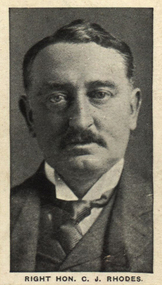
Photograph (black & White), Right Honorable Cecil John Rhodes - South Africa
Cecil Rhodes was a British businessman, mining magnate and politician in South Africa. He was Prime Minister of the Cape Colony from 1890 to 1896. He believed in British Imperialism and he and his British South Africa Company formed the territory of Rhodesia in the early 1890s. He was forced to resign as Prime Minister in 1896 after the disastrous Jameson Raid, an unauthorised attack on Paul Kruger's South African Republic (Transvaal), which sent his brother to prison convicted of high treason and nearly sentenced to death. This event contributed to the outbreak of the Second Boer War. Rhodes went to Kimberley in a political move. During the war the military felt he was more of a liability than an asset and found him intolerable. The officer commanding the garrison of Kimberley, Lieutenant Colonel Robert Kekewich, experienced serious personal difficulties with Rhodes because of the latter's inability to co-operate. However, he still remained a leading figure in the politics of southern Africa. Rhodes was dogged by ill health his whole life. He died in 1902, aged 48, at his seaside cottage in Muizenberg. He was cared for by Leander Starr Jameson during his illness, becoming a trustee of his estate and residuary beneficiary of his will, which allowed him to continue living in Rhode's mansion after his death. His final will left a large area of land on the slopes of Table Mountain. Part of the estate became the upper campus of the University of Cape Town, another part became the Kirstenbosch National Botanical Garden. The rest was spared development and is now an important conservation area. His will also provided for the establishment of the Rhodes Scholarship. Individual image from photographed poster of tobacco and cigarette cards.cecil rhodes, mining magnate south africa, politician south africa, prime minister cape colony, british south africa company, rhodesia, jameson raid, paul kruger, south africa republic, transvaal, second boer war, kimberley, robert kekewich, leander starr jameson, muizenberg, table mountain, university of cape town, kirstenbosch national garden -
 Federation University Historical Collection
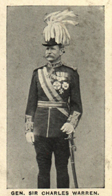
Photograph (black & White), General Sir Charles Warren - South Africa
General Sir Charles Warren was an officer in the British Royal Engineers. He was one of the earliest European archaeologists ofthe Holy Land. Much of his military service was spene in British South Africa. Previously he was police chief, the Head of the London Metropolitan Police during the Jack the Ripper murders. In 1876, the Colonial Office appointed him special commissioner to survey the boundary between Griqualand West and the Orange Free State. For this work he was made a Companion of the Order of St Michael and St George in 1877. He was appointed special commissioner to investigate "native questions" in Bechuanaland and commanded the Northern Border Expedition troops in quelling the rebellion there. In 1879 he became Administrator of Griqualand West. The town Warranton in the Northern Cape Province of South Africa is named after him. In 1882 the Admiralty sent him to Sinai to discover what had happened to Professor Edward Palmer's archaeological expedition. He discovered the members had been robbed and murdered, located their remains and brought their killers to justice. For this he was created a Knight Commander of the Order of St Michael and St George in 1883 , also Knight of Justice of the Order of St John of Jerusalem and in 1884 elected a Fellow of the Royal Society. In 1884 Warren was sent as HM Special Commissioner to command a military expedition to Bechuanaland, to assert British sovereignty in the face of encroachments from Germany and the Transvaal and to suppress the Boer freebooter states of Stellaland and Goshen, which were backed by the Transvaal and were stealing land and cattle from the local Tswana tribes. This became known as the Warren Expedition and achieved its aims without bloodshed. Warren was recalled and in 1885 was made Knight Grand Cross ofthe Order of St Michael and St George. In 1885 Warren stood for election for Parliament but lost the vote. In 1886 he was appointed Commissioner of Police of the Metropolis following Sir Edmund Henderson's resignation. Criticised continually for his decisions and actions he resigned in November 1888. Prior to this time he was appointed Knight Commander of the Order of the Bath, January 1888. On the outbreak of the Boer War in 1899 he returned to service and commanded the 5th Division of the South African Field Force. In January 1990, Warren bungled the second attempted relief of Ladysmith at Tugela River. At the Battle of Spion Kop, January 1990 he had operational command and his failure of judgement, delay and indecision despite his superior forces culminated in the disaster. It has been said that Warren was "perhaps the worst" of the British generals in the Boer War and certainly the most "preposterous". Redvers Buller in a letter to his wife described him as "a duffer", responsible for him losing him "a great chance". Warren was recalled to Britain in August 1900 and never again commanded troops in the field. Individual image from photographed poster of tobacco and cigarette cards.holy land, sir charles warren, british royal engineers, archaeologist, british south africa, london metropolitan police, jack the ripper, colonial office, commissioner, griqualand west, orange free state, companion of the order of st michael and st george, bechuanaland, northern border expedition, warrenton, sinai, professor edward palmer, knight commander of the order of st michael and st george, knight of justice of the order of st johnof jerusalem, fellow of the royal society, knight grand cross of the order of st michael and st george, boer war, redvers buller, knight commander of the order of the bath -
 Federation University Historical Collection
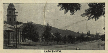
Photograph (black & White), Ladysmith - South Africa
Ladysmith is a city in the Uthukela District of KwaZulu-Natal, South Africa. In 1847 after buying the land from the Zulu King Mpande, a number of Boers settled in the area and called it the Republic of Klip River. The Republic was annexed by the British in the same year and on 20 June 1850 it was proclaimed a township called Windsor. In October 1850 the name changed to Ladysmith after Juana Maria de los Delores de Leon Smith, also known was "Lady Smith", the Spanish wife of Sir Harry Smith, the Governor of the Cape Colony. He was also High Commissioner in South Africa from 1847 to 1852. A for was built in 1860 to protect the villagers from the Zulu. During the Second Boer War British commander Lieutenant General Sir George White made Ladysmith his centre of operations for the protection of Natal against the Boer forces. A number of short lived battles were fought for the control of the town. After suffering many casualties the British retreated to Ladysmith. While the British regrouped in the town, Boer forces surrounded Ladysmith. The siege lasted 118 days during one of the most crucial stage of the war. Three attempts by General Sir Redvers Buller to break the siege resulted in defeat for the British forces at the Battles of Colenso, Spion Kop and Vaal Krantz. The Boer forces attempted to break the siege. This led to the Battle of Platrand, or Wagon Hill, south the town. Buller finally broke the siege in February 1900 after defeating the Boers. Sir Winston Churchill, a young war correspondent was present at the Relief of Ladysmith after having been taken prisoner - between Ladysmith and Colenso - and escaping earlier during the war.Individual image from photographed poster of tobacco and cigarette cards.ladysmith, south africa, zulu, boers, republic of klip river, windsor, lady smith, sir harry smith, governor, cape colony, high commissioner, sir george white, natal, siege of ladysmith, sir redvers buller, battle of colenso, battle of platrand, sir winston churchill, wagon hill -
Federation University Historical Collection
Exercise Book, William Baragwanath, William Baragwanath's Exercise Book, 1898, 1898
William Baragwanath studied at the Ballarat School of Mines, obtained a Geology certificate in 1911. He was born on 01 August 1878 at Ballarat. He joined the Victorian Department of Mines in 1897 and was Chief Mining Surveyor from 1924 to 1943. Baragwanath died at Prahran on 20 Septemeber 1966.Marbled blue card covered exercise book with yellow tape spine containing handwritten notes by William Baragwanath on dividing land problems, earthworks, refraction, etc; Headings include: Tom Joe Smith ballarat school of mines, earthworks, land problems, refraction, william baragwanath, -
Federation University Historical Collection
Book, Ballarat School of Mines Submission for New Courses, 1982, 03/1982
Cream card covered A4 book with black plastic spine. It is planning document 2.8.2ballarat school of mines, new courses, automotive air conditioning, carpentry and joinery, horticulture, land laboratory, barkly street campus, applied ceramics, weaving, plumbing and gasfitting, hairdressing, sheetmetal, management -
Federation University Historical Collection
Report, Ballarat School of Mines Pilot Conservation Project, 1980, 06/1980
Submission for funds for a pilot conservation project . Planning Document 11.80ballarat school of mines, planning document, t. white, tafe, national youth advisory group, land degredation, unemployment, economics, dryland salting -
 Federation University Historical Collection
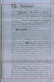
Document, Lease for the Former Ballarat Circuit Court House, Lydiard Street, Ballarat, 1870 and 1877, 05/1870; 1877
The Ballarat School of Mines opened in the former Ballarat Circuit Court House in 1870. The court house was demolished in 1915 to make way for the Ballarat Technical Art School. The Ballarat School of Mines is a predeccessor of Federation University Australia..1) Handwritten agreement on blue paper with green thread. The agreement is between the Board of Land and Works and Redmond Barry and others concerning a seven year lease of the former Ballarat Circuit Court House for use as a mining school (the Ballarat School of Mines). .2) Four lined fooscap pages relating to specifications of several works required to the Old Court House. .3) Rough notes on proposed lease of the Court House.lease, former ballerat circuit court house, redmond barry, legal, crown solicitor, gurner, robert davidson, warrington rogers, john warrington rogers, william warrington rogers, rivett henry bland, p. saunders, james williams, ballarat school of mines, ballarat school of mines establishment -
Federation University Historical Collection
Magazine - Booklet, Ballarat School of Mines Students' Magazine, 1939, 1939
School Council, Members of Staff, List of Full Course Students 1939, Full Course Commercial Students, S.M.B. Magazine Committee 1939, Editorial, Personal Column, Obituary - Frank Ponsonby, The Old School, The Railway Workshops, The S.M.B. Literary Society, Papua: Land of Contrasts, Old Boys' Association, Snapshots in Berlin, Fumes from the Lab, Arts & Crafts Gossip, Sport, Commercial Notes, The Junior Techs, Junior Techs SportsBlue, yellow and green covered magazine with black and green font. 70 pages including advertisements.ballarat school of mines, magazine, r. mchutchison, e. gribble, m. coward, n. rigney, o. raisbeck, g. myers, f. malseed, e. fitzgerald, m. linklater, j. wilkinson, m. dolan, j. woolcock, b. martin, g. downing, h. j. hassell, n. tatlock, a. wilson, h. trevenan, w. hender, dr. j. r. pound, a. r. gordon, mr procter, a. helm, r. desnoy, frank ponsonby, g. t. myers, h. christensen, enid johnston, k. h. wilkie, isobel boustead, eric j. gashler, violet d'angri, m. hayes, marian peirce, mr hillman, k. gingell, g. crouch, r. menhennett, j. menhennett, mr cornell, e. mann, a. vaughan, d. jelbart, a. moorhouse, d. gilmore, p. richards, j. nott, r. monteith, j. martin, f. jelbart, k. waller, a. gilpin, b. robinson, d. coad, m. dalla, u. kersey, j. cooper, p. coombs, l. stapleton, u. chisholm, l. peoples, l. stephens, j. hall, h. patterson, a. brown, v. evans, j. hallidale, c. clogan, d. ditchfield, j. daniel, e. theobald, g. james, j. unsworth, helen stichnoth, w. rowe, winsome hender, c. w. rowe, j. hosie, e. stephens, i. mclachlan, r. stoneman, m. gleeson, k. stoneman, h. tonkin, f. harland, r. bulluss, t. davies, r. gladman, m. thomas, e. salter, d. mcgregor, a. spence, g. taylor, j. pyke, r. allisey, i. clow, r. p. flower, l. taylor, b. neale, j. norman, f. p. manning, paul manning -
 Federation University Historical Collection
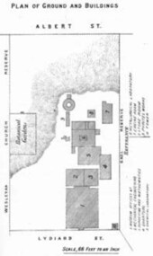
Book - Annual Report 1880, The School of Mines Ballaarat Annual Report, 9 February, 1880, 1880
The School of Mines Annual Report, 9 February, 1881, Additional Examination Statute 1880, Balance Sheet, Certificates Granted by Council, Donations and Fees - carriage of, Extracts from Visitors' Book, Fees, Form of Bequest, Honorary Correspondents, Life Governors, Mining and Mineral Contributions Invited - Paper of Particulars, Museum - open to visitors, Office Bearers, Obituary, Report of the Lecturer in Mathematics, Report of the Lecturer in Mining-Land- and Engineering-Surveying, Report of the Lecturer in Mechanical Engineering, Report of the Lecturer in Telegraphy, Report of the Curator of the Museum (with Plans), Report of the Superintendent of Laboratories, Subjects and Lecturers, Subjects and Examiners, Statement of Receipts and Expenditure for the year 1880, Subscriptions and Donations from 1 January to 31 December 1880, The Lal-Lal Iron Ore Deposits - (with Section and Plan)Pale green booklet of 70 pages, Annual Report 1880. Image of Guage Test Tower, Image of The School of Mines, Plan of Ground and Buildings - Albert Street, The School of Mines Ballaarat - The Museum - Plan of Groundfloor, Image of the Lal-Lal Iron Ore Deposits, Moorabool Riverthe school of mines, annual report, additional examination statute 1880, balance sheet, certificates granted by council, donations and fees - carriage of, extracts from visitors' book, fees, form of bequest, honorary correspondents, life governors, mining and mineral contributions invited-paper of particulars, museum open to visitors, office bearers, obituary, report of the lecturer in mathematics, report of the lecturer in mining-land and engineering-surveying, report of the lecturer in mechanical engineering, report of the lecturer in telegraphy, report of the curator of the museum (with plans), report of the superintendent of laboratories, subjects and lecturers, subjects and examiners, statement of receipts and expenditure for the year 1880, subscriptions and donations from 1 january to 31 december 1880, the lal-lal iron ore deposits-(with section and plan), obituary - sir redmond barry - arthur leahy - jacob upfold - john day, mr james oddie, dr. r. f. hudson, john victor, chas. wm. thomas, w. h. shaw, walter d. campbell, ferdinand m. krause, joseph flude, geo. perry, w. hy. barnard, examination statute, his excellency sir wm. f. drummond jervois, charles h. pearson, t. brodribb, professor pepper, james mitchell, robert adam, wm. lant carperter, h. b. de la poer wall, w. h. brokenshire, arthur parker, henry parkinson, c. davies, simon richards, c. v. gorton, c. r. blackett, david jones, wilberforce dyke, ferdinand krause, ballarat school of mines museum, ballarat school of mines museum plan, lal lal ore deposits, moorabool river, william land carpenter, william jervois, william henry tbarnard -
Federation University Historical Collection
Book, Tourism at the University of Ballarat - 1996 AH&TE Conference: Historic Mining Site Management, 1996
Tourism at the University of Ballarat - 1996 AH&TE Conference: Historic Mining Site ManagementWhite soft covered folder. mary hollick, public land in victoria, heritage legislation commonwealth, management issues, list of key mining heritage trails, preliminary market research, survey locations, university of ballarat, school of business, historic mining site, historic mining site management, tourism, mining heritage trails -
Federation University Historical Collection
Book, University of Ballarat - Daylesford: Product Development Plan
University of Ballarat - Daylesford: Product Development Plan JT701/Tourism Planning and Development Lecturer/Tutor: Mary HollickWhite soft covered book of 68 pages including 13 appendices.university of ballarat, daylesford, mary hollick, andrew cyples, todd edmonds, kylie harrington, nicole landers, jess lewis, hepburn shire council, introduction, methodology, history of daylesford, infrastructure audit, hepburn mineral springs & springs reserve, hepburn springs bath house, lake daylesford, the convent gallery, road access to daylesford, rail and coach access to daylesford, the lake house, wombat gardens & victoria park, jubillee lake, jim crow, wombat, sir charles hotham, warren hastings, central, tipperary and golden mineral springs, lavandula lavender farm, the macaroni factory, smeaton, guilford, trentham, maldon, creswick, castlemaine, clunes, dja dja wurrung, swiss/italian, mineral water, hepburn mineral springs reserve, jubilee lake, central springs, tipperary springs, golden springs