Showing 112 items
matching watt river
-
 Nillumbik Historical Society Incorporated
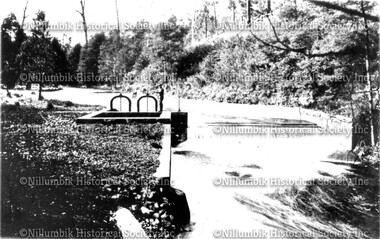
Photograph - Black & white photograph, Concrete weir across Watts River
... Photograph Concrete weir across Watts River Black & white photograph ...Black & white photographdiamond creek state school, diamond creek, nillumbik school -
 Port Fairy Historical Society Museum and Archives
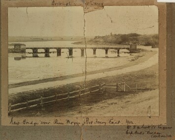
Photograph, New Bridge over River Moyne Port Fairy East 1902
New Bridge over River Moyne Port Fairy East 1902Black and white photograph view of new bridge over the river Moyne taken in 1902New Bridge over River Moyne Port Fairy East 1902 (handwritten) Mr G.W.Scott C.E.Engineer. .......Watts Riordan Contractorsbridge, river, moyne, river moyne, traffic -
 Wangaratta Art Gallery
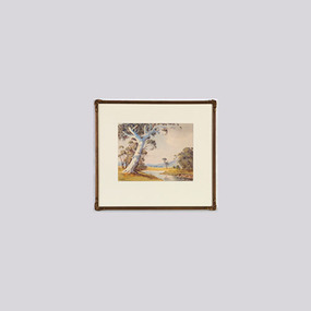
Painting, V. R. Watt, Untitled (Pastoral landscape with river), unknown
Rural City of Wangaratta Collection. Gift of Leslie Morrison. Donated in memory of Bruce Morrison, Shire Engineer.A realistic pastoral landscape, painted in watercolour using a colour palette of green, blue, brown, yellow, and white.Obverse: VR WATT/ (bottom left corner)wangaratta art gallery, v. r. watt, landscape, painting, pastoral -
 Orbost & District Historical Society
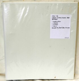
folder, Orbost Bridges - Snowy River Road Bridges, 1974 1976
This folder was compiled in October 2015 from documents, magazines. papers and photographs donated by David Jellie, engineer in charge 1974 - 1976. In early 1974, as an Engineer with the Country Roads Board, David came to Orbost as the Supervising Engineer for the construction of the new bridges which were part of an 8.4km Orbost bypass road design. This was a major project involving not only a new bridge over the Snowy River (including Lochiel Lagoon), but other bridges over Ashby’s Gulch and Watt’s Gulch. These new bridges were opened in November 1976 with the unveiling of a plaque on the eastern end of the $2.4M Snowy River Bridge. (ref. May Leatch)This item is a useful reference tool on the construction history of the Snowy River Road bridges.A white plastic folder - Orbost Bridges - Snowy River Road Bridges. it contains newspaper articles, booklets, photographs and documents relating to the construction of the Snowy River Road Bridge in 1974 -1976.on front cover - 1974 - 76 ORBOST / SNOWY RIVER ROAD BRIDGES * construction * photos * articles * plans Donated by David Jellie Oct 2015snowy-river-bridges jellie-david -
 Orbost & District Historical Society
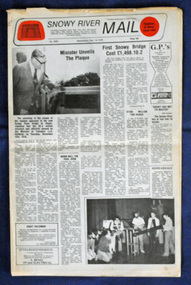
newspaper, Snowy River Mail, 1.12.1976
In early 1974, as an Engineer with the Country Roads Board, David came to Orbost as the Supervising Engineer for the construction of the new bridges which were part of an 8.4km Orbost bypass road design. This was a major project involving not only a new bridge over the Snowy River (including Lochiel Lagoon), but other bridges over Ashby’s Gulch and Watt’s Gulch. These new bridges were opened in November 1976 with the unveiling of a plaque on the eastern end of the $2.4M Snowy River Bridge. The new bridge, built by the CRB at a cost of $2.4 million, is 1.6 metres above the record flood levels of 1971. (ref. May Leatch) This newspaper contains contemporary reports of a significant event in Orbost.A Snowy River Mail newspaper, dated 1.12.1976. It contains news articles, photographs and advertisements. The main article relates to the official opening of the Snowy River Bridge and the unveiling of a plaque on the eastern approach. It also contains a history of the first Snowy River Bridge.snowy-river-bridge orbost-bridges snowy-river-mail -
 Orbost & District Historical Society
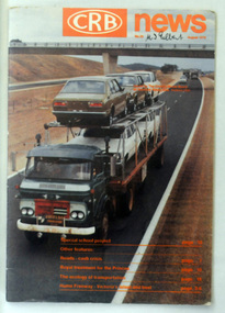
magazine, CRB News, August 1976
By 1910 it had become apparent that there was a need for a central roads authority to take over responsibility from the Board of Lands and Works for the care and management of the main roads of the state of Victoria. Because there was no consistent and systematic policy for road maintenance Victorian roads were in a deplorable condition. At this time the use of the motor car accentuated the demands for better roads. As a result of these needs the Country Roads Act 1912 was proclaimed in 1913 providing for the establishment of the Country Roads Board as a central road authority with responsibility for those roads within the State considered to be main roads. the C.R.B. was responsible for the construction of roads and bridges including the Snowy River road bridges in Orbost. This was a major project involving not only a new bridge over the Snowy River (including Lochiel Lagoon), but other bridges over Ashby’s Gulch and Watt’s Gulch. These new bridges were opened in November 1976 with the unveiling of a plaque on the eastern end of the $2.4M Snowy River Bridge. (ref. May Leatch) This is a useful reference tool on the history of the construction of the Snowy River road bridges.A journal, titled "CRB News" . On the front cover the title is in orange print with No. 33 August 1976 above a coloured photo of a truck carrying two tiers of new vehicles along a main sealed road. It contains information and photos of the construction of the Snowy River road bridges.on front cover - handwritten in black - "M. I. Gilbert"crb-news country-roads-board snowy-river-road-bridges -
 Orbost & District Historical Society
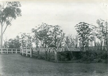
black and white photograph, August 1897
This is a photograph of the bridge from the Orbost side. The first pile bridge over the Snowy River was just completed by Mr Jim Granter when the 1891 flood took out the centre,. There were differences of opinion as to whether the council should pay . The Shire Secretary, Mr John Draffin, persuaded them to honour their obligations. Mr Granter and Mr Clarke finished it as a suspension bridge which was opened by Mrs William Watt. Soon after a mob of cattle stampeded, the weight snapped the cable, letting one side sag. Mr R.P. Cameron repaired it and this bridge remained until 1922. "In 1890 the contract for a bridge was let to Mr James Granter for £1450. This structure with additions and improvements made to it was to cost the ratepayers about £2,500, and its erection was proceeded with in a very satisfactory manner until, just as the greater-part of the work had been completed, the flood of 1891 came down on it, piling up mountains of logs, timber and debris against the piers, which had not been made wide enough apart to allow for. contingencies of this kind. The structure held out bravely until the turn of the flood and then gave way with a crash, about five bays from the centre disappearing in the stream." ( Snowy River Mail August 12 1893) This item is a pictorial record of one of the first bridges across the Snowy River in Orbost.A black / white photograph of the old wooden suspension bridge over the Snowy River. There are two copies 919.1 and 919.2. There are two other photos showing the whole bridge taken from further back.on back - "Orbost Bridge...."snowy-river-bridge-orbost granter-james -
 Orbost & District Historical Society
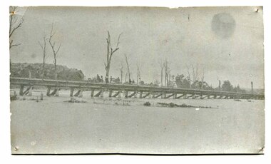
black and white photograph, January 1934
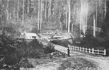
Orbost has been subject to major floods throughout its history, such as those which left the town isolated in 1934, 1952, 1971 and 1978. It is recorded that the Snowy River broke its banks and flooded the flats 104 times between 1884 and 1978. Extensive flooding in Eastern Victoria during June 1978, caused widespread damage to roads, road closures and hazards to traffic, particularly over the Queen's Birthday holiday weekend.This is a pictorial record of a significant event in Orbost's history.A very faded black / white photograph of flood water under the railway viaduct at watt's Gulch.orbost-flood-1934 railway-viaduct-orbost -
 Orbost & District Historical Society
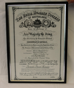
certificate/award, after 1934
This certificate was presented to Donald David Thomson , sleeper hewer, aged 42 years for rescuing S.C. Curtis, aged 52, G. Wylie, aged 54, J. Dalgleish, aged 5 from flood waters at White gulch on the Snowy River on January 8, 1934. (The certificate reads as White's Gulch but should be Watt's gulch.) Although damage estimated at 500,000 pounds was caused by the unprecedented floods along the Snowy River, no lives were lost because of the courageous actions of men like Donald Thomson.A framed copy of a printed and hand-written certificate from the Royal Humane Society of Australia awarded to Donald David Thomson for rescuing victims of the floodwaters in Orbost January 1934. It is dated 6.3.1934.Printed at top of certificate: THE ROYAL HUMANE SOCIETY / OF AUSTRALASIA. Has names of Society patrons and committee as well as names and ages of those rescued. award certificate royal-humane-society flood snowy-river 1934 thomson-david -
 Eltham District Historical Society Inc
Photograph, M.Jefferson, Watts Bridge Hotel, Fernshaw, Vic
... , Shire of Eltham Pioneers Photograph Collection, Watt's River ...Source: National Library, Canberra from Album of Victorian Views, photographed by C. Nettleton This photo forms part of a collection of photographs gathered by the Shire of Eltham for their centenary project book,"Pioneers and Painters: 100 years of the Shire of Eltham" by Alan Marshall (1971). The collection of over 500 images is held in partnership between Eltham District Historical Society and Yarra Plenty Regional Library (Eltham Library) and is now formally known as the 'The Shire of Eltham Pioneers Photograph Collection.' It is significant in being the first community sourced collection representing the places and people of the Shire's first one hundred years.Digital imagefernshaw, other areas, sepp, shire of eltham pioneers photograph collection, watt's river -
 Eltham District Historical Society Inc
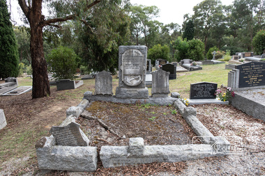
Photograph, Peter Pidgeon, Grave of (Captain) Gordon Watts-Phillips and Mary Hilda Watts-Phillips, Eltham Cemetery, Victoria, 5 April 2021
Charles Gordon Watts-Phillips was born in 1849 at Forest Hill, Surrey, England, the son of Dramatic Author, Watts Phillips, and Lily Mariner. He departed England for Australia around 1874. His sister Roland was a favourite Australian actress of the early 1900s. Gordon as he was known, whilst residing in Goolwa, South Australia and working as a clerk met and married a widow, Jane Luxon (nee Miller) on the 7th August, 1876 at the Wesleyan Church in Strathalbyn, South Australia. Jane, Gordon’s elder by some 11 years was born in Ireland in 1838, the daughter of Robert Joseph Miller, a carpenter and Jane Miller. She had previously married Captain William Luxon in 1861 at Encounter Bay, South Australia at age 22 and they had four children: William (1864), George Robert (1865), Miriam Louisa (1867) and Harriet Jane (1869), all born at Encounter Bay. Gordon and Jane had two further children together: Caroline Roland Watts-Phillips (1877 Islington S.A.) and Charles Gordon Watts-Phillips (1879 Yatala, S.A.). At some stage, Jane then deserted her husband. Gordon obtained a master's certificate and was a part owner of a small trader. He had also been captain of one of the passenger boats on the Darling River. He was reputedly a popular coastal skipper. By 1891 Gordon was the Captain of the S.S Omeo operating around Sale, Victoria. In August of that year some of the heaviest flooding of the Thomson River ever experienced in twenty years occurred over the 3rd and 4th of August. Gordon, and others, rescued the lives of many families over that period for which he was awarded a Bronze Medal by the Royal Humane Society. By 1892 the S.S. Omeo had passed to another Captain and Gordon subsequently retired from the sea and moved to Melbourne. Whilst residing in Coburg, Victoria, Gordon met Mary Hilda Harvey Huxley who was living in Brunswick. Mary was born in Horsham, the daughter of George Harry Huxley, a miner, and Emma Deane. Having not heard from Jane for some years and believing her dead, Gordon and Mary marry at Carlton on Christmas Eve, 1900. Interestingly, an announcement of the marriage was not placed in The Age newspaper until September 1903, nearly three years after the event by which time Gordon and Mary had a son, Victor Gordon Watts-Phillips, born 8 February 1903 in Carlton. Within months of the placement of this marriage announcement, his former wife, Jane, makes a reappearance but apparently does not interfere and Mary and Gordon continue to live together as husband and wife. Around the same time in late 1903, Gordon’s brother, Basil Watts Phillip wrote from London to the Victoria Police seeking assistance to locate his brother. He had last heard from him in a letter dated Cunninghame, Gippsland, 1891. He indicated that about 1893 Gordon and Jane and their two children were living at Beaconsfield Parade, Albert Park but the whereabouts of all was now unknown. He mentioned Gordon had also been awarded 21 guineas by Judge Boucaut on the 26th February 1884, also a silver medal, for arresting two ruffians who had brutally assaulted a jockey (in South Australia) and that he had been awarded the Royal Humane Society's medal, London, and in 1891, was presented with the Royal Humane Society's certificate of merit (Victoria). Basil also stated his brother had lost the sight of one eye through a stab he received in New York and had a scar on his temple, one on the wrist, two under the shoulder blade, and one on the thigh, and two bullet wounds in the leg. Basil’s quest was published in the Melbourne Herald and assistance was soon forthcoming to the Police. In June 1906 Gordon made his Will, leaving all his estate to his youngest son Victor. Mary was appointed Executrix and it was witnessed by Olive Huxley, married woman, and James Huxley, a pottery maker. James was subsequently killed in France in May 1918. Gordon and Mary have a second son, Basil Douglas born in Carlton in 1911 but he dies as toddler in 1913. At some point Gordon and Mary made their home at Eltham though official electoral roll records record them at Little Flinders Street Melbourne, employed as a caretaker and from 1906 in Brunswick as a decorator then painter. Eltham may have been a ‘holiday’ home but it seems Mary was actively engaged in the community as a newspaper report in the Advertiser in 1922 not long after Gordon’s death indicates Mary was one of the best known and best liked ladies of the Eltham district. She was actively engaged in all matters, tending towards the welfare of the district. At the time of Gordon’s death Mary was president of the Ladies' Public Hall Committee, responsible for the conduct of numerous, and successful entertainments. Gordon’s first and only legal wife, Jane Luxon Watts-Phillips nee Miller, died 6 November 1921 and was buried 8 November 1921 at Springvale Cemetery. Jane had lived 34 years in South Australia and 30 years in Victoria. With Jane now dead, Gordon was now officially a widower and just three weeks later, the retired master mariner of Eltham at age 55 remarried Mary, 42, of 174 Hickford Street, East Brunswick on the 29th November 1921 in the Parish of St Cuthbert, East Brunswick. Gordon died at their home, ‘The Rest’, at 174 Hickford Street, East Brunswick on February 9, 1922 and was buried at Eltham Cemetery on February 11. An interesting link is established with the heavy floods of August 1891 by the erection of a tombstone in the Eltham cemetery. The stone bears the inscription: - “In loving memory of (Captain) Gordon, dearly beloved husband of Mary Watts Phillips. Died 9th February 1922, aged 62 years." Beside the stone is a replica, carved in a marble scroll, of the Royal Humane Society of Australia's Certificate of merit. Part of the wording of this certificate is as follows:- “At a general court of directors holder at the offices of the society at Melbourne on the 6th day of September 1891, it was resolved that the courage and humanity displayed by Gordon Watts Phillips aged 30-years captain of S.S. Omeo, Sale, in rescuing many families from drowning during the heavy floods on Thomson River on 3rd and 4th of August 1891 call for the admiration of the court, and justly entitles him to the certificate of merit of this society, which is hereby awarded." Unbeknownst to Gordon, his second and subsequent legal marriage to Mary initiated a revocation of his Will of 1906, which had solely benefited his son Victor. Consequently, Mary had to apply for Letters of Administration and the only legal beneficiaries would be Mary and his two children by Jane. On June 18, 1940, at age 61, Mary married 70-year-old Arthur Ernest Fenn in Melbourne. Unfortunately for her, Arthur died a year later in July 1941 and was buried in the Cohuna Cemetery near Echuca. Mary lived a further 8 years, passing away suddenly July 4, 1948 in Carlton, and was buried July 7 with her beloved husband Gordon, at Eltham Cemetery. In Loving Memory of (Captain) Gordon Dearly beloved husbandof Mary Watts-Phillips Died 9th Feb. 1922, aged 62 years Also Mary Hilda Loved wife of above Died 4th July 1948 "At rest"Born Digitaleltham cemetery, gravestones, (captain) gordon watts-phillips, mary hilda harvey watts-phillips (nee huxley) -
 Melton City Libraries
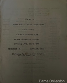
Booklet, Region 14 Rural Fire Brigades Association, 1968
Formation of the Mt Cottrell Fire Brigades Group In its policy of creating smaller compact groups of fire brigades the Country Fire Authority Regional Officer Harry Rothsay in 1967 requested that the following 6 brigades surrounding Mt Cottrell transfer from their respective groups. Melton and Rockbank from Bacchus Marsh Group, Toolern Vale and Sydenham from Mt Macedon Group and Truganina and Werribee from Little River Group forming a new Group to the be named Mt Cottrell Fire Brigades Group. Group Headquarters was established at the Ferris road residence of Melton Captain E W Bon Barrie, who was elected Group and Communications Officer of Mt Cottrell. E W (Eddie) Gillespie and Keith Watt of the Toolern Vale brigade were appointed Deputy Group Officer and Group Secretary respectivelyRegion 14 Rural Fire Brigades Association First Annual Demonstration programmeemergency services -
 Melton City Libraries
Document, Mount Cottrell Fire Brigade Group standing order and constitution, 1978
In its policy of creating smaller compact groups of fire brigades the Country Fire Authority Regional Officer Harry Rothsay in 1967 requested that the following 6 brigades surrounding Mt Cottrell transfer from their respective groups. Melton and Rockbank from Bacchus Marsh Group, Toolern Vale and Sydenham from Mt Macedon Group and Truganina and Werribee from Little River Group forming a new Group to the be named Mt Cottrell Fire Brigades Group. Group Headquarters was established at the Ferris road residence of Melton Captain E W Bon Barrie, who was elected Group and Communications Officer of Mt Cottrell. E W (Eddie) Gillespie and Keith Watt of the Toolern Vale brigade were appointed Deputy Group Officer and Group Secretary respectively. Documents from the Mount Cottrell Fire Brigade Group emergency services -
 Melton City Libraries
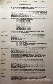
Document, Country Fire Authority Wireless Licence Schedule, 1971
Early member of the Bush Fire Brigade, Bon Barrie saw the need for improved speed of communication. With the formation of the Country Fire Authority by mid 1950 Melton introduced H F high frequency two way radio sets. A set was located in the Barrie home, which was an idea location to observe smoke sighting given its 360 degree view of the distant horizon. A large antenna was built to improve reception and sending strength. Author – Edna Barrie hand written notes. In its policy of creating smaller compact groups of fire brigades the Country Fire Authority Regional Officer Harry Rothsay in 1967 requested that the following 6 brigades surrounding Mt Cottrell transfer from their respective groups. Melton and Rockbank from Bacchus Marsh Group, Toolern Vale and Sydenham from Mt Macedon Group and Truganina and Werribee from Little River Group forming a new Group to the be named Mt Cottrell Fire Brigades Group. Group Headquarters was established at the Ferris road residence of Melton Captain E W Bon Barrie, who was elected Group and Communications Officer of Mt Cottrell. E W (Eddie) Gillespie and Keith Watt of the Toolern Vale brigade were appointed Deputy Group Officer and Group Secretary respectively. The Base Radio was installed at the Group Headquarters by the CFA. Brigades contributed to half the cost. A grant of $1000 was made available by the Shire of Melton in 1969 toward the cost of VHS (Very High Frequency) replacing the HF(High Frequency) Radios which has been introduced in the 1950’s. Shire of Werribee and the City of Keilor supported Werribee and Sydenham in a similar manner. The Call sign for the new group became VL3LY VHF Channel 1 163.12 m/cs. HF 3836 k/cs. Mount Cottrell Group's Wireless Licence Scheduleemergency services, local identities -
 Melton City Libraries
Map, Streets of Melton, 1963
MELTON’S STREETS Heritage Week 2014 What’s in a Name? Alphabetical List Aboriginal place names, Early Family Names and landowners, Agricultural, Shop and Commercial premises, Places and Events Melton & District Historical Society Street Naming Project 1972 – c 1998 Suburb Name – KURUNJANG - Kirkton, 1972, Brookfield, West, 1988 Melton and Town Centre - A joint collaboration with the Shire of Melton and Subdivision Developers ARNOLD Court – Family house - Arnolds Creek ALKEMADE Drive Family – Lime kilns Coimadia ALEXANDRA Street 1902 – Corination of King Edward VII and Queen Alexandra AVIATOR Place Event, location of plane crash – Jimmy Melrose 1936 Adina ?Annibee - Anniba? Agricultural Avon court .. .. BAKERY Square - Location of Jongebloed shop, bakehouse and stables BALUK Place Aboriginal BARLEYCORN Place Agricultural BILLING Place Name of Jimmy Melrose Uncle Noel Pemberton Billing BLACKWOOD Drive - Alexander Blackwood 1860c Registrar BARRIES Road C. E. Barrie “Darlingsford” farmer 1911, chaff mill owner BROOKLYN Road Staughton family residence. 1875 – Dismantled c 193? CAHILL Drive Family - Glenville Dairy CAMERON Court Family Canopus Place ? CANALLAN Drive Early Surveyor CAMPBELL Court Aviation – Melrose passenger 6th July 1936 CARBERRY Drive Michael, early landowner family CAREW Court Edward and Michael. Royal Hotel. Vera (Carew) Forran Singer - Opera CASEY Court Family CASHIN Court Family CHEVIOT Court Agriculture, breed of sheep CHESNEY Road was re named ( Minns Road being duplicated c 1973) CHRISTINA Crescent Christina McPherson, daughter of James and Mary Mary McPherson. Died 1955 aged 85 years COLLYER Close a deleted street (parallel to Yuille) re-used CORRIEDALE Road Breed of sheep CORR Court Teacher at first school, landowner CROXTON Court Name of the Hornbuckle and Knox family home DALEY Court - William Daley and family 1865 Bootmaker High Street DARLINGSFORD Boulevard - Name of early homestead Thomas B Darling 1853 DJERRIWARRH Court - Parish County of Bourke - very early map. DODEMAIDE Place Early land owners - Melton Football Team had 6 brothers playing c 1924 DONALD Court McPherson family 6 generations in Melton in 1936 DOUGAL Court DUNCAN Court .. .. DUNVEGAN Circuit Home of the McPherson family, castle Isle of Skye Name of bluestone house Smith Street (now at Willows) EMIL Court Jongebloed family EXELL Avenue Farming family Melton Sth- Closer Settlement 1907 EXFORD Road Exe former name of the Werribee river FARMER Court Name of early postmistress FERRIS Road John Ferris Farmer HANNAH Close First name of Hannah Watts – midwife HAYBALE Place Agricultural HELDER Court Early surveyor J Helder Wedge map HEWSON Street Winston Hewson Shire Engineer – check title c 1960 HENRY Street Township map c 1860 HESTON Street Heston Phoenix – C.J. Melrose plane HILDEGARDE Court Jimmy Melrose’s mothers name HOMESTEAD Close HORNBUCKLE Cres Farmers. Three members of family - Shire Presidents HURLEY Street Farmers IAIN Court Descendent of James and Mary McPherson JAMES MELROSE Drive Name appears on 2013 Melton information map JANG Place KURUN – jang KIRKTON Drive Name of the McPherson family home Toolern Vale Road KIRWIN Street Michael early landowners (deleted for freeway construction) KILPATRICKS Road Deleted when Barries Road was extended across Station Rd KOROROIT Court Early map, Parish of Kororoit. Creek name KNOX Circuit Family – Hornbuckle “Croxton Park” KURRUNJANG Drive Aboriginal name for people of the red earth – Suburb name Lara Place ? LLOYD Court Garage owners High Street. Laura lived to 100 years D 1955 LUBY Court John Luby – Crown Grant Land Title LITTLE Court MANNING Avenue Richard, hotel owner 1891 MARGARET Drive McPherson family McDONALD Street Melton South family name McKENZIE Street Township c1860 MORROW Street Early name MOWBRAY Crescent Name of English Melton, popularly believed origin of Melton MYERS Court Early setters c 1866 Crown Grant Land Title NIMMO Street Early name NIXON Street Name submitted by Mary nee Nixon Collins c1985 OLDERSHAW Road Early builder PALMERSTON Street Early township map c 1860 PEART Court Early name PENNYROYAL Avenue Plant growing by the creek. Early name used for the Toolern Toolam Creek PINKERTON Street Family name and early street map PINNACLE Crescent Agricultural - type of wheat PHOENIX Circuit C.J. Melrose Phoenix Heston Plane 2013 map PRATT Family PRIOR Court PYKE Place Brothers – early settlement 1838 RADFORD Court Land owners and business operators. Former Royal Hotel Grocer High Street demolished 1970 RAGLAN Court Hotel 19th century Lord Raglan RALEIGHS Road Oliver Reierson family (Norweigen) Shopkeeper – Dressmakers RIDDELL Drive (misspelt Riddle) Resident and land owner RODERICK Road McPherson family – a re occurring name ROLLAND Court Jones family ROSS Court Daniel. Landowner. Agnes Ross music teacher RUSSELL Court Robert. Early land surveyor of Melton 1853 RYAN Court Family early landowner. Member of the 1862 Road Board SHEBLER Place Augustus early Melton resident – Golden Fleece Hotel SHEEPFOLD Court Farming SHERWIN Court Sherwin Street earliest Township map– became Golf course SMITH Street Early township map. STRATHULLOH Circuit Strathtulloh Homestead. STAUGHTON Street Family – LARGE land owners Strachan ? SWANEY Court Marie Swaney earlier resident of Strathtulloh. SUTHERLAND Family name TOOLERN Street TOOLAM – TOOLERN Creek TULLIDGE St Road marked on 1861 map UNITT Street Early Township c 1860 WALLACE Square Cr Jack Wallace 5 terms as President 46 years unopposed WATTS Court Hannah Watts – midwife, cottage hospital WALSINGHAM Name of house of Minns family. From Walsingham Norfolk England WESTLEY Place Name of Jimmy Melrose Percival Gull Plane WESTLAKE Drive Early resident WHICKHAM Street Family Name Melton South WILSON Road Albert, Melton South YUILLE Street William Cross, early landowner, Rockbank run Zoomed in section of Melton Streets including Church and High Streetlandscapes of significance -
 Marysville & District Historical Society
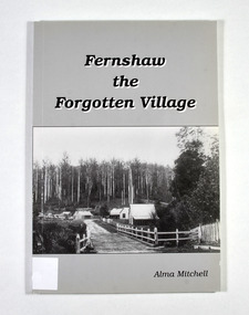
Book - Paperback book, Alma Mitchell, Fernshaw the Forgotten Village, 2001
... tourist destination in Victoria. fernshaw victoria history watts ...The story of the village of Fernshaw between the dates of 1864 and 1890.Paperback. Front cover has the title and author's name. Also, a black and white photograph taken by John W. Lindt entitled 'First Glimpse of Fernshaw'.non-fictionThe story of the village of Fernshaw between the dates of 1864 and 1890.fernshaw, victoria, history, watts river, yarra track -
 Marysville & District Historical Society
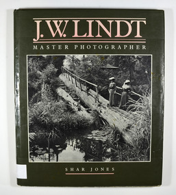
Book - Hardcover book, J.W. Lindt Master Photographer, 1985
... and Watts River area and he sold over 25,000 images of the Black ...A book of photographs taken by John William Lindt of locations and scenery throughout the world.A book of photographs taken by John William Lindt of locations and scenery throughout the world. John William Lindt (1845–1926), was a German-born Australian landscape and ethnographic photographer, early photojournalist, and portraitist. John Lindt was responsible for a folio of photographs of the Fernshaw and Watts River area and he sold over 25,000 images of the Black Spur from his original negatives. In 1895 he was able to purchase land on the North East side of the Black Spur and subsequently built his home and guesthouse "The Hermitage" from where he continued his photographic career. In 1913 he collaborated with Nicholas Caire to produce a tourist booklet on the area. In 1925 the Argus reported that Lindt "continues to produce remarkable and most artistic pictures of the beauties of mountain landscape. He is not a believer in the blurred effects favoured by many ... instead he is a master of detail." Aged 81 Lindt died of heart failure during disastrous bushfires on 19 February 1926 at the Hermitage. He was survived by his wife Catherine who continued to run ‘The Hermitage’ guest house before she retired to the city.Hardcover. Front cover photograph-Log Bridge at the Hermitage c1910photography, artistic, john william lindt, la trobe collection, shar jones -
 Marysville & District Historical Society
Ephemera (Item) - Book page, Unknown
... launching place box hill ringwood lilydale watts river yea river ...A page from a unknown book regarding Marysville and the surrounding district including Narbethong, Healesville and Warburton.A page from a unknown book regarding Marysville and the surrounding district including Narbethong, Healesville and Warburton.marysville, victoria, narbethong, healesville, warburton, toolangi, launching place, box hill, ringwood, lilydale, watts river, yea river, sylvia falls, don road, wood's point, baw baws, maroondah reservoir, graceburn weir, mt juliet, fernshaw -
 Eltham District Historical Society Inc
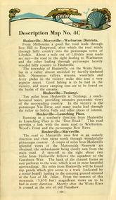
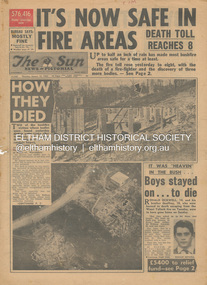
Newspaper - Newspaper articles, Sun News-Pictorial, It's Now Safe in Fire Areas; Death Toll Reacxhes 8, The Sun News-Pictorial, Thursday, January 18, p1, 1962
Various news articles pertaining to the January 1962 Victorian bushfires in the Dandenong and Healesville districts which by the third day had encompassed large areas of the State. Specific Eltham Shire districts mentioned include Warrandyte on page 1, St. Andrews and Smith’s Gully on page 2, St. Andrews on page 3 and 43, Panton Hill and Warrandyte on p23 and Hurstbridge on page 44 • It's Now Safe in Fire Areas; Death Toll Reaches 8, p1 (Illust.) • How they died, pp1-2 • It was “heaven” in the bush … Boys stayed on . . . to die, pp1-2 (Illust.) • Towns take stock as danger drops, p2 • £5400 to the relief fund, p2 • Fire now threat to Otways, p2 • Pensioners lose all, p2 • “…If Only The Rain Had Come” … and then it came to town, p3 (Illust.) • Our best rain since May • It halted at Grandma’s front gate, p5 (Illust.) • Now that the rain has come; It’s time for the clean-up, p6 • Wisps of smoke where flames danced, p7 • Charitry’s a loser, p7 • War Service homes claim, p7 • Help’s on way, p7 (Illust.) • Came with their gifts …, p7 • Fire summons for youth; “sparked the rest”, p9 • Three gaoled, p9 • They had to camp out at Wye River, p9 (Illust.) • “Probe Fires” – Stoneham, p9 • The Fourth Day: Scorched Earth!, pp22-23 (Illust.) • This home was saved but - , p22 (Illust.) • Relief Centre, p23 (Illust.) • Homeless, p23 (Illust.) • So little was left, p43 (Illust.) • Tommy saved his cat, p43 (Illust.) • Some were lucky … and some were tired, p44 (Illust.) tom fielding collection, victorian bushfires - 1962, victorian bushfires – 1962, ronald ockwell, geoffrey ockwell, woori yallock, william ockwell, leslie ockwell, linda may ockwell, black friday, victorian bushfires – 1939, warrandyte, arthur brown, harold vernon betton, bloom road, william smith, olinda, bushfire relief fund, yarra glen, healesville, railway line, st. andrews, smith’s gully, otway ranges, eric watts, edith varty, inverness road, mt. evelyn, wye river, panton hil, heather sullivan, warrandyte hall, montrose, kalorama, mrs e. tucker, shirley tucker, margaret tucker, joane tucker, roger tucker, trevor tucker, ann quinton, tom dunstan, hurstbridge hall