Showing 113 items matching "watts river"
-
 Orbost & District Historical Society
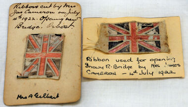
ribbon, 1922
They are both pieces of ribbon used for the opening of the snowy River Bridge on July 4 1922. The ribbon was made to represent the red, white and blue of the British flag. This was the second bridge over the Snowy River. The first bridge was officially opened in August, 1893 (ref. S.R.M. 12.8.1893) by Mrs W. Watt, the mother of Councillor Watt, who presided over the opening of the 1922 bridge. This bridge was extensively damaged when a herd of cattle allegedly stampeded over it causing the cable to snap. Even after repairs it became obvious that a new bridge was needed. This second bridge, was built by the Victorian Railways and the Country Roads Board. Constructed at a cost of 35,000 pounds and used second-hand girders from the Flinders Street- Spencer Street viaduct. On July 4 1922 it was officially opened by Mrs James Cameron. Unfortunately, her husband, who had long championed the building of the bridge so that it would be ready for the railway to continue to the border, was too ill to attend the ceremony. In fact, James Cameron died on July 13 after a long and severe illness (ref. S.R.M. 20.7.1922). Souvenirs kept by enthusiastic spectators like this have helped to preserve the history of an important Orbost event.Two pieces of ribbon in British flag pattern of red, white and blue. These have been pinned onto card with a handwritten description of their history.snowy-river cameron souvenir -
 Orbost & District Historical Society
May 1900
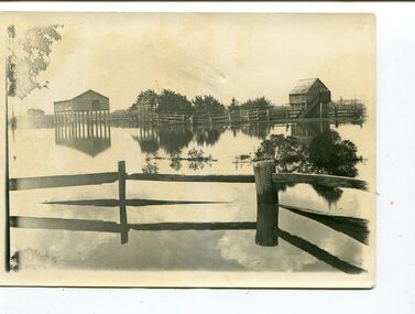
This is a photograph of the original Orbost / Snowy River Bridge , a suspension bridge which opened in 1893. It has been taken when the Snowy River was in flood. It is similar to other photographs held in The State Library, Victoria. The Snowy River Mail and Tambo and Croajingolong Gazette Sat 12 Aug 1893 records the opening of this bridge as "the most important public event that has yet been commemorated in Eastern ......The Messrs McLeod, with whom the first settlement of this district is generally associated, took up their residence on the eastern bank of the Snowy River about the year 1841 or 42. The late Mr W. Roadknight and Mr T. T. Stirling took possession of the territory on the western side of the Snowy about 35 years ago. During the occupation of the country by cattle owners, very little progress was made in the way of roads and bridges, and except to the hardy and lexperienced bushman, it might have been generally regarded as inaccessible. About the year 1877, however, the late Mr James Robertson eldest son of Mr James Robertson, of Lochend farm, selected land now occupied by his father, about four miles from Orbost on the west bank of the river, Mr John Cameron visited the. district shortly after a .tour of inspection and returned later with his brothers, James and Alick Gameron, but found that during their absence Mr Ernest Watt had found his way on the scene and pegged out a selection, thus anticipating the advent of the Camerons by about 12 hours. We understand that a Mr Kidd, who selected the property now occupied by Mr W. J. Ross, at Pumpkin Point, was one of the earliest batch of settlors.........."This is a pictorial record of an early bridge across the Snowy River at Orbost.A black / white photograph of a suspension bridge with flood waters below the bridge.orbost-bridge suspension-bridge snowy-river -
 Orbost & District Historical Society
black and white photographs, 1890s
Peter Cameron, came to Orbost in 1885, at the age of 69, having sold his farm at Geelong. Peter bought the property ―Glen Avon from a Mr Street. The home was situated at the bottom of the paddock, near the corner of Morley and Livingstone streets. The farm stretched from Tennyson Street to the end of Snaggers Lane and along the river frontage to “Carinya” Cameron Home. In the Gippsland Times on Wednesday. 2 Jul 1890 on Page 3 is an article titled "THE SNOWY RIVER CALAMITY" which describes an ".unexpectedly sudden rush of water down the flats..... the terrified people commenced to remove their stock from the land and the work of saving property was continued all day ............ many head of cattle were washed away.......The river road, for its entire length, is obliterated, and the approaches to the bridge at Watt's Gulch are gone, with the enormous volume of flood water," These photographs are pictorial records of a significant event in the history of Orbost. There are few personal records of the very early floods.Three black / white photographs of wooden buildings with flood water in foreground. There are post and rail fences. 3193.2 has been taken from a distance.on back -" "Glenavon east of Lagoon 1897 Feb"floods-orbost-1890s glenavon-orbost -
 Orbost & District Historical Society
black and photograph / postcard, 1.4.1908
This postcard was sent to Annie Gilbert (Mrs John Gilbert) of Tullagoota, Orbost. It was written by "Grace", probably her sister, Grace Cameron Annie Gilbert was the daughter of John Cameron who selected the first land on the Snowy River flats. This is a photograph of the original Orbost / Snowy River Bridge , a suspension bridge which opened in 1893. It has been taken when the Snowy River was in flood. It is similar to other photographs held in The State Library, Victoria. The Snowy River Mail and Tambo and Croajingolong Gazette Sat 12 Aug 1893 records the opening of this bridge as "the most important public event that has yet been commemorated in Eastern ......The Messrs McLeod, with whom the first settlement of this district is generally associated, took up their residence on the eastern bank of the Snowy River about the year 1841 or 42. The late Mr W. Roadknight and Mr T. T. Stirling took possession of the territory on the western side of the Snowy about 35 years ago. During the occupation of the country by cattle owners, very little progress was made in the way of roads and bridges, and except to the hardy and lexperienced bushman, it might have been generally regarded as inaccessible. About the year 1877, however, the late Mr James Robertson eldest son of Mr James Robertson, of Lochend farm, selected land now occupied by his father, about four miles from Orbost on the west bank of the river, Mr John Cameron visited the. district shortly after a .tour of inspection and returned later with his brothers, James and Alick Gameron, but found that during their absence Mr Ernest Watt had found his way on the scene and pegged out a selection, thus anticipating the advent of the Camerons by about 12 hours. We understand that a Mr Kidd, who selected the property now occupied by Mr W. J. Ross, at Pumpkin Point, was one of the earliest batch of settlers.........."This item is associated with Annie Gilbert (nee Cameron) reported to have been the first white girl to be born in Orbost. It is a pictorial record of the suspension bridge over the Snowy River which has since been replaced twice.A faded black / white postcard of a bridge across a river. There are cattle in the river and the banks are tree-covered.on back - a hand-written letter addressed to Mrs J. Gilbert Tullagoota Orbost.cameron-annie suspension-bridge-orbost snowy-river-orbost -
 Orbost & District Historical Society
folder, Orbost Bridges - Snowy River Road Bridges, 1974 1976
This folder was compiled in October 2015 from documents, magazines. papers and photographs donated by David Jellie, engineer in charge 1974 - 1976. In early 1974, as an Engineer with the Country Roads Board, David came to Orbost as the Supervising Engineer for the construction of the new bridges which were part of an 8.4km Orbost bypass road design. This was a major project involving not only a new bridge over the Snowy River (including Lochiel Lagoon), but other bridges over Ashby’s Gulch and Watt’s Gulch. These new bridges were opened in November 1976 with the unveiling of a plaque on the eastern end of the $2.4M Snowy River Bridge. (ref. May Leatch)This item is a useful reference tool on the construction history of the Snowy River Road bridges.A white plastic folder - Orbost Bridges - Snowy River Road Bridges. it contains newspaper articles, booklets, photographs and documents relating to the construction of the Snowy River Road Bridge in 1974 -1976.on front cover - 1974 - 76 ORBOST / SNOWY RIVER ROAD BRIDGES * construction * photos * articles * plans Donated by David Jellie Oct 2015snowy-river-bridges jellie-david -
 Orbost & District Historical Society
newspaper, Snowy River Mail, 1.12.1976
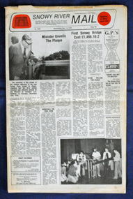
In early 1974, as an Engineer with the Country Roads Board, David came to Orbost as the Supervising Engineer for the construction of the new bridges which were part of an 8.4km Orbost bypass road design. This was a major project involving not only a new bridge over the Snowy River (including Lochiel Lagoon), but other bridges over Ashby’s Gulch and Watt’s Gulch. These new bridges were opened in November 1976 with the unveiling of a plaque on the eastern end of the $2.4M Snowy River Bridge. The new bridge, built by the CRB at a cost of $2.4 million, is 1.6 metres above the record flood levels of 1971. (ref. May Leatch) This newspaper contains contemporary reports of a significant event in Orbost.A Snowy River Mail newspaper, dated 1.12.1976. It contains news articles, photographs and advertisements. The main article relates to the official opening of the Snowy River Bridge and the unveiling of a plaque on the eastern approach. It also contains a history of the first Snowy River Bridge.snowy-river-bridge orbost-bridges snowy-river-mail -
 Orbost & District Historical Society
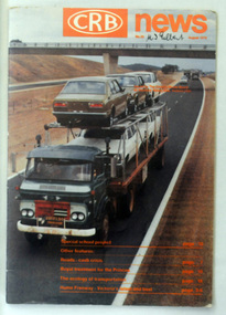
magazine, CRB News, August 1976
By 1910 it had become apparent that there was a need for a central roads authority to take over responsibility from the Board of Lands and Works for the care and management of the main roads of the state of Victoria. Because there was no consistent and systematic policy for road maintenance Victorian roads were in a deplorable condition. At this time the use of the motor car accentuated the demands for better roads. As a result of these needs the Country Roads Act 1912 was proclaimed in 1913 providing for the establishment of the Country Roads Board as a central road authority with responsibility for those roads within the State considered to be main roads. the C.R.B. was responsible for the construction of roads and bridges including the Snowy River road bridges in Orbost. This was a major project involving not only a new bridge over the Snowy River (including Lochiel Lagoon), but other bridges over Ashby’s Gulch and Watt’s Gulch. These new bridges were opened in November 1976 with the unveiling of a plaque on the eastern end of the $2.4M Snowy River Bridge. (ref. May Leatch) This is a useful reference tool on the history of the construction of the Snowy River road bridges.A journal, titled "CRB News" . On the front cover the title is in orange print with No. 33 August 1976 above a coloured photo of a truck carrying two tiers of new vehicles along a main sealed road. It contains information and photos of the construction of the Snowy River road bridges.on front cover - handwritten in black - "M. I. Gilbert"crb-news country-roads-board snowy-river-road-bridges -
 Marysville & District Historical Society
Book - Hardcover book, J.W. Lindt Master Photographer, 1985
... and Watts River area and he sold over 25,000 images of the Black ...A book of photographs taken by John William Lindt of locations and scenery throughout the world.A book of photographs taken by John William Lindt of locations and scenery throughout the world. John William Lindt (1845–1926), was a German-born Australian landscape and ethnographic photographer, early photojournalist, and portraitist. John Lindt was responsible for a folio of photographs of the Fernshaw and Watts River area and he sold over 25,000 images of the Black Spur from his original negatives. In 1895 he was able to purchase land on the North East side of the Black Spur and subsequently built his home and guesthouse "The Hermitage" from where he continued his photographic career. In 1913 he collaborated with Nicholas Caire to produce a tourist booklet on the area. In 1925 the Argus reported that Lindt "continues to produce remarkable and most artistic pictures of the beauties of mountain landscape. He is not a believer in the blurred effects favoured by many ... instead he is a master of detail." Aged 81 Lindt died of heart failure during disastrous bushfires on 19 February 1926 at the Hermitage. He was survived by his wife Catherine who continued to run ‘The Hermitage’ guest house before she retired to the city.Hardcover. Front cover photograph-Log Bridge at the Hermitage c1910photography, artistic, john william lindt, la trobe collection, shar jones -
 Marysville & District Historical Society
Document (Item) - Document-Table, Judith Vimpani, Yarra Track Hostelries- Marysville to Woods Point, Unknown
A document outlining all the hostelries that existed along the Yarra Track between Marysville and Wood's Point.A document outling all the hostelries that existed along the Yarra Track between Marysville and Wood's Point.yarra track, marysville, wood's point, woods point, fernshaw, paradise plains, black spur, mount grant, george edwards, walker family, melbourne, new chum, hit & miss restaurant, mr clifford, michael woods, glen watts, tri bhean hotel, ewen cameron, ewen hugh cameron, thomas barton, butler's wood's point directory, globe hotel, swanston street, mount juliet, ben more & c, jordan district, jefferson's watts bridge inn, matthew jefferson, reefer's hotel, boyle's hotel, william henry johnson, samuel boyle, black spur hotel, fisher's creek, narbethong, fisher's home hotel, black spur inn, frederick fisher, william hodson, wood's point road, acheron river, acheron bridge hotel, john robson, granton, clifford, wilks creek, wilks creek hotel, patrick maloney, steavenson, marysville hotel, australian hotel, junction hotel, the dutchman's restaurant, henry kuyper, william podlech, mount arnold, mount arnold hotel, charles schultz, james toohey, john gleeson, joy burchall, ian newman, henry brockman, belle isle, belle elle, bellell creek, upper yarra, guerin's bridge, bell's hotel, henry petty, celia moran, ruth petty, cumberland creek, cumberland creek store and restaurant, cumberland creek hotel, charles edwin hargreaves, annie hargreaves, urina hargreaves, alice hargreaves, healesville, josiah hargreaves, henderson drysdale, henry whelan, halfway house, thomas smith, svendson, gosling, donovans creek, chesterville, perry's hotel, john perry, perry's coach and horses hotel, edward courtney, scandinavian hotel, the swede's, walker's hotel, jacob burchart, golden fleece, theodore kappler, george koehler's hotel, david walker, millicent walker, elsie jowett, bill walker, big river, royal mail hotel, shaw's, slingsby davies, edwin jones, elizabeth jane parker, sandridge, archibald charles edwin jones, matlock, alexander myers, frank berwick frederick jones, ned jones, jennie jones, sophie milllicent parker jones, thomas shaw, dorothy walker, travellers rest hotel, reefton, summers, john fehring, f fehring, katerina fehring, john christoph blumeyer, anne fehring, john baker, evelyn observer, anna katrina baker, hannah catherine baker, john frederick baker, mcmahon's creek, oaks, the springs, st clair, sinclair's valley, mountain home hotel, neilson, collins, waters, jan emma sinclair, john sinclair, mr cox, peter sinclair, willie we have missed you hotel, spring vale hotel, robert matthews, thomas crawford -
 Marysville & District Historical Society
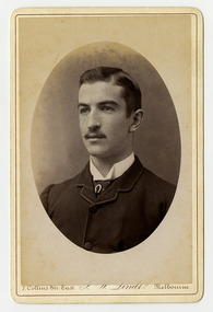
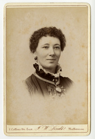
Photograph (Item) - Black and white portrait, John William Lindt, 1870s
... Fernshaw and Watt River Scenery, Victoria ( c.1878-82), Scenery ...A black and white portrait of an unknown man taken by John William Lindt.A black and white portrait of an unknown man taken by John William Lindt. John William Lindt was born in Germany in 1845. At 17 he took a working passage to Australia on a Dutch sailing ship. Taking up work as an itinerant piano-tuner, he traveled amongst towns in Victoria and New South Wales before settling in Grafton in 1863 where he became assistant and apprentice to photographer Conrad Wagner. After a brief return to Germany in 1867 Lindt took over management of Wagner’s studio in 1869. He married Wagner’s daughter, Anna on 13 January 1872. Over 1873-1874, using the slow and laborious wet-plate collodion process, John Lindt produced photographs of the local indigenous people both in their environment conducting actual traditional ceremonies in the Clarence River district, and in his studio. Twelve of this series is included in his 1874 album Australian Aboriginals. John Lindt moved to Melbourne in 1876 where he worked for Batchelder & Co. before opening his own opulent studios at number 7 at the top of Collins Street opposite the Treasury, in 1877. John Lindt's business of this period was wide-ranging, and included portraits, records of Melbourne public buildings and streetscapes, the Botanical Gardens, and Port Melbourne. He was a welcome photographer of members of parliament and other Melbourne personalities, their society and cultural life including the theatre, and was known as a ‘rich man’s photographer’ for those whose families he grouped informally on the lawns in front of their mansions, with servants at the rails of the upstairs balconies. He continued with landscape, producing folios Fernshaw and Watt River Scenery, Victoria ( c.1878-82), Scenery on the Ovens and Buckland Rivers, Victoria (c.1878–82) and Lorne, Louttit Bay and Cape Otway Ranges (1883). Sales of his Black Spur scenery amounted to approximately 25,000 copies printed from the original negatives between 1882 and 1892. John Lindt, in collaboration with Nicholas John Caire, produced a tourist booklet on the area around "The Hermitage" in 1913.7 Collins Str. East/ J.W. Lindt/ Melbournejohn william lindt, conrad wagner, australian aboriginals, batchelder & co, nicholas john caire, anna lindt -
 Marysville & District Historical Society
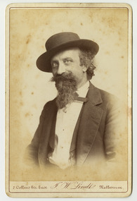
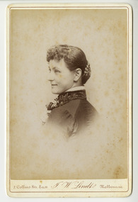
Photograph (Item) - Black and white portrait, John William Lindt, 1870s
... Fernshaw and Watt River Scenery, Victoria ( c.1878-82), Scenery ...A black and white portrait of an unknown woman taken by John William Lindt.A black and white portrait of an unknown woman taken by John William Lindt. John William Lindt was born in Germany in 1845. At 17 he took a working passage to Australia on a Dutch sailing ship. Taking up work as an itinerant piano-tuner, he traveled amongst towns in Victoria and New South Wales before settling in Grafton in 1863 where he became assistant and apprentice to photographer Conrad Wagner. After a brief return to Germany in 1867 Lindt took over management of Wagner’s studio in 1869. He married Wagner’s daughter, Anna on 13 January 1872. Over 1873-1874, using the slow and laborious wet-plate collodion process, John Lindt produced photographs of the local indigenous people both in their environment conducting actual traditional ceremonies in the Clarence River district, and in his studio. Twelve of this series is included in his 1874 album Australian Aboriginals. John Lindt moved to Melbourne in 1876 where he worked for Batchelder & Co. before opening his own opulent studios at number 7 at the top of Collins Street opposite the Treasury, in 1877. John Lindt's business of this period was wide-ranging, and included portraits, records of Melbourne public buildings and streetscapes, the Botanical Gardens, and Port Melbourne. He was a welcome photographer of members of parliament and other Melbourne personalities, their society and cultural life including the theatre, and was known as a ‘rich man’s photographer’ for those whose families he grouped informally on the lawns in front of their mansions, with servants at the rails of the upstairs balconies. He continued with landscape, producing folios Fernshaw and Watt River Scenery, Victoria ( c.1878-82), Scenery on the Ovens and Buckland Rivers, Victoria (c.1878–82) and Lorne, Louttit Bay and Cape Otway Ranges (1883). Sales of his Black Spur scenery amounted to approximately 25,000 copies printed from the original negatives between 1882 and 1892. John Lindt, in collaboration with Nicholas John Caire, produced a tourist booklet on the area around "The Hermitage" in 1913.7 Collins Str. East/ J.W. Lindt/ Melbournejohn william lindt, conrad wagner, australian aboriginals, batchelder & co, nicholas john caire, anna lindt -
 Marysville & District Historical Society
Letter (Item) - Hand written letter, John William Lindt, 1903
... Fernshaw and Watt River Scenery, Victoria ( c.1878-82), Scenery ...A letter written to Maurice Keppel by John William Lindt in 1903.A letter written to Maurice Keppel by John William Lindt in 1903. John William Lindt was born in Germany in 1845. At 17 he took a working passage to Australia on a Dutch sailing ship. Taking up work as an itinerant piano-tuner, he traveled amongst towns in Victoria and New South Wales before settling in Grafton in 1863 where he became assistant and apprentice to photographer Conrad Wagner. After a brief return to Germany in 1867 Lindt took over management of Wagner’s studio in 1869. He married Wagner’s daughter, Anna on 13 January 1872. Over 1873-1874, using the slow and laborious wet-plate collodion process, John Lindt produced photographs of the local indigenous people both in their environment conducting actual traditional ceremonies in the Clarence River district, and in his studio. Twelve of this series is included in his 1874 album Australian Aboriginals. John Lindt moved to Melbourne in 1876 where he worked for Batchelder & Co. before opening his own opulent studios at number 7 at the top of Collins Street opposite the Treasury, in 1877. John Lindt's business of this period was wide-ranging, and included portraits, records of Melbourne public buildings and streetscapes, the Botanical Gardens, and Port Melbourne. He was a welcome photographer of members of parliament and other Melbourne personalities, their society and cultural life including the theatre, and was known as a ‘rich man’s photographer’ for those whose families he grouped informally on the lawns in front of their mansions, with servants at the rails of the upstairs balconies. He continued with landscape, producing folios Fernshaw and Watt River Scenery, Victoria ( c.1878-82), Scenery on the Ovens and Buckland Rivers, Victoria (c.1878–82) and Lorne, Louttit Bay and Cape Otway Ranges (1883). Sales of his Black Spur scenery amounted to approximately 25,000 copies printed from the original negatives between 1882 and 1892. John Lindt, in collaboration with Nicholas John Caire, produced a tourist booklet on the area around "The Hermitage" in 1913. Maurice Keppel, from Ireland, was one of the first landholders in the newly surveyed town of Marysville in 1864. He and his wife ran the successful Keppel’s Australian Hotel. Two of their sons, John and Jerry, established a farm and opened up the surrounding high country. The Keppel lease was one of the longest held in the high country and the Keppel Family were amongst Marysville's pioneering families.maurice keppel, keppel family, keppel's australian hotel, marysville, victoria, john william lindt, conrad wagner, australian aboriginals, batchelder & co, nicholas john caire, anna lindt -
 Marysville & District Historical Society
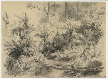
Artwork, other (Item) - Pencil Sketch, Louis Buvelot, Fernshaw 17.2.83, 1883
... of Healesville. Situated on the Watts River, near where a log had fallen ...A copy of an early pencil sketch of Fernshaw in Victoria.A copy of an early pencil sketch of Fernshaw in Victoria by Louis Buvelot. Louis Buvelot ( 1814–1888), born Abram-Louis Buvelot, was a Swiss landscape painter who lived 17 years in Brazil and following 5 years back in Switzerland stayed 23 years in Australia, where he influenced the Heidelberg School of painters. Arriving in Melbourne in February 1865, after leaving the cold of Switzerland, which was impacting on his health, for the warmth of Australia, Buvelot was in business as a photographer in Bourke Street for a year but soon resumed his painting. He lived in Melbourne for a number of years before moving to Fitzroy. The National Gallery of Victoria purchased two of his paintings and he continued painting until his death in 1888. He was buried at the Boroondara Cemetery, where a large monument was erected in his memory. Fernshaw was a rural township 63 km northeast of Melbourne and 10 km northeast of Healesville. Situated on the Watts River, near where a log had fallen making a convenient crossing, Fernshaw was settled in the 1860s. It provided good country for orchards and berry growing. The location was at the foot of Blacks Spur, with Mounts Juliet and Mondah rising on either side, providing spectacular scenery. There were nearby fern gullies giving rise to the name – ‘shaw’ is old English for thicket or wood. By 1875 Fernshaw had a post office (1865), two hotels, a school (1871), and stores. It was famed for its beauty, attracting tourists. In 1886 the Melbourne and Metropolitan Board of Works began work on the Watts River water catchment scheme – later to become Maroondah – and the Board obtained approval for the catchment country to be reserved and kept free of settlement. This required the removal of the Fernshaw township, which was completed by about 1890.Fernshaw 17.2.83louis buvelot, fernshaw, victoria, national gallery of victoria, switzerland, boroondara cemetery, kew cemetery, artist -
 Federation University Historical Collection
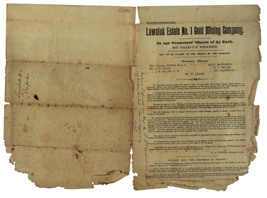
Document, Lawaluk Estate No. 1 Gold Mining Company Prospectus, 1934, 26/06/1934
Prospectus for the Lawaluk Estate No. 1 Gold Mining Company Prospectus, 1934 squire, r.b. squire, lawalul estate no. 1 gold mining company, mining, shares, william collard smith, g.b. hogg, j.b. regan, s. maddison, r.t> moore, kames clements, h.a. o'connor, w.e. watts, d. fitzpatrick, lawaluk estate, mt lawaluk, robert allan, surveyor, leigh river -
 Wangaratta Art Gallery
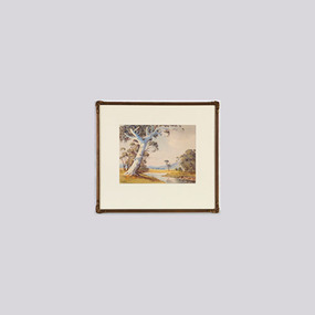
Painting, V. R. Watt, Untitled (Pastoral landscape with river), unknown
... landscape with river) Painting V. R. Watt ...Rural City of Wangaratta Collection. Gift of Leslie Morrison. Donated in memory of Bruce Morrison, Shire Engineer.A realistic pastoral landscape, painted in watercolour using a colour palette of green, blue, brown, yellow, and white.Obverse: VR WATT/ (bottom left corner)wangaratta art gallery, v. r. watt, landscape, painting, pastoral -
![Junction of the Rivers Yarra and Watt, Near Healesville / [by] Nicholas Caire, circa 1876](/media/collectors/550653872162f11fb04854aa/items/577740e5d0cdd10a5c0de011/item-media/57774153d0cdd10a5c0e0662/item-fit-380x285.jpg) Kew Historical Society Inc
Kew Historical Society IncPhotograph, Anglo-Australasian Photographic Company, Junction of the Rivers Yarra and Watt, Near Healesville, c. 1876
... watt river.... / (GENERAL SERIES.) / No. 3. / JUNCTION OF THE RIVERS YARRA AND WATT.... nicholas caire (1837-1918) yarra river watt river bridge wooden ...Nicholas Caire was born on Guernsey in the Channel Islands in 1837. He arrived in Adelaide with his parents in about 1860. In 1867, following photographic journeys in Gippsland, he opened a studio in Adelaide. From 1870 to 1876 he lived and worked in Talbot in Central Victoria. In 1876 he purchased T. F. Chuck's studios in the Royal Arcade Melbourne. In 1885, following the introduction of dry plate photography, he began a series of landscape series, which were commercially successful. As a photographer, he travelled extensively through Victoria, photographing places few of his contemporaries had previously seen. He died in 1918. Reference: Jack Cato, 'Caire, Nicholas John (1837–1918)', Australian Dictionary of Biography.An original, rare photograph from the series 'Views of Victoria: General Series' by the photographer, Nicholas Caire (1837-1918). The series of 60 photographs that comprise the series was issued c. 1876 and reinforced a neo-Romantic view of the Australian landscape to which a growing nationalist movement would respond. Nicholas Caire was active as a photographer in Australia from 1858 until his death in 1918. His vision of the Australian bush and pioneer life had a counterpart in the works of Henry Lawson and other nationalist poets, authors and painters.Albumen Silver Photograph, mounted on Board.printed in ink on support l.c.: JUNCTION OF THE RIVERS YARRA AND WATT, NEAR HEALESVILLE. / COPYRIGHT REGISTERED. printed in ink on support reverse c.: VIEWS OF VICTORIA. / (GENERAL SERIES.) / No. 3. / JUNCTION OF THE RIVERS YARRA AND WATT, NEAR HEALESVILLE / The junction is situated about 3 miles from Healesville, and 35 miles from the mouth of the Yarra. The souces / of the Watt are to be found at the head of the Black Spur, and, being fed by a number of creeks and springs, its / waters gain considerable force for several miles before joining those of the Yarra. The "Old Bridge," at the junction, / is the name given to this crossing-place, which has been partly swept away by late floods. The depth of the Yarra here / is from 15 to 20 feet; that of the Watt, about 10 feet. printed in ink on support reverse l.c.l.: J.W. FORBES, Agent, printed in ink on support reverse l.c.: ANGLO-AUSTRALASIAN PHOTOGRAPHIC COMPANY, MELBOURNE. printed in ink on support reverse l.c.r.: 10 Temple Court, Collins Street West.nicholas caire (1837-1918), yarra river, watt river, bridge, wooden bridge, healesville -
 Port Fairy Historical Society Museum and Archives
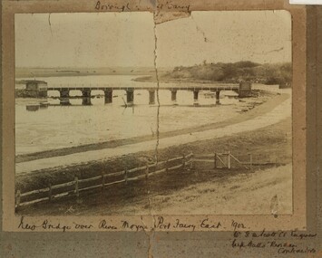
Photograph, New Bridge over River Moyne Port Fairy East 1902
New Bridge over River Moyne Port Fairy East 1902Black and white photograph view of new bridge over the river Moyne taken in 1902New Bridge over River Moyne Port Fairy East 1902 (handwritten) Mr G.W.Scott C.E.Engineer. .......Watts Riordan Contractorsbridge, river, moyne, river moyne, traffic -
 Melton City Libraries
Document, Country Fire Authority Wireless Licence Schedule, 1971
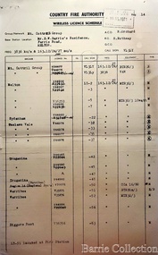
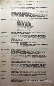
Early member of the Bush Fire Brigade, Bon Barrie saw the need for improved speed of communication. With the formation of the Country Fire Authority by mid 1950 Melton introduced H F high frequency two way radio sets. A set was located in the Barrie home, which was an idea location to observe smoke sighting given its 360 degree view of the distant horizon. A large antenna was built to improve reception and sending strength. Author – Edna Barrie hand written notes. In its policy of creating smaller compact groups of fire brigades the Country Fire Authority Regional Officer Harry Rothsay in 1967 requested that the following 6 brigades surrounding Mt Cottrell transfer from their respective groups. Melton and Rockbank from Bacchus Marsh Group, Toolern Vale and Sydenham from Mt Macedon Group and Truganina and Werribee from Little River Group forming a new Group to the be named Mt Cottrell Fire Brigades Group. Group Headquarters was established at the Ferris road residence of Melton Captain E W Bon Barrie, who was elected Group and Communications Officer of Mt Cottrell. E W (Eddie) Gillespie and Keith Watt of the Toolern Vale brigade were appointed Deputy Group Officer and Group Secretary respectively. The Base Radio was installed at the Group Headquarters by the CFA. Brigades contributed to half the cost. A grant of $1000 was made available by the Shire of Melton in 1969 toward the cost of VHS (Very High Frequency) replacing the HF(High Frequency) Radios which has been introduced in the 1950’s. Shire of Werribee and the City of Keilor supported Werribee and Sydenham in a similar manner. The Call sign for the new group became VL3LY VHF Channel 1 163.12 m/cs. HF 3836 k/cs. Mount Cottrell Group's Wireless Licence Scheduleemergency services, local identities -
 Melton City Libraries
Map, Streets of Melton, 1963
MELTON’S STREETS Heritage Week 2014 What’s in a Name? Alphabetical List Aboriginal place names, Early Family Names and landowners, Agricultural, Shop and Commercial premises, Places and Events Melton & District Historical Society Street Naming Project 1972 – c 1998 Suburb Name – KURUNJANG - Kirkton, 1972, Brookfield, West, 1988 Melton and Town Centre - A joint collaboration with the Shire of Melton and Subdivision Developers ARNOLD Court – Family house - Arnolds Creek ALKEMADE Drive Family – Lime kilns Coimadia ALEXANDRA Street 1902 – Corination of King Edward VII and Queen Alexandra AVIATOR Place Event, location of plane crash – Jimmy Melrose 1936 Adina ?Annibee - Anniba? Agricultural Avon court .. .. BAKERY Square - Location of Jongebloed shop, bakehouse and stables BALUK Place Aboriginal BARLEYCORN Place Agricultural BILLING Place Name of Jimmy Melrose Uncle Noel Pemberton Billing BLACKWOOD Drive - Alexander Blackwood 1860c Registrar BARRIES Road C. E. Barrie “Darlingsford” farmer 1911, chaff mill owner BROOKLYN Road Staughton family residence. 1875 – Dismantled c 193? CAHILL Drive Family - Glenville Dairy CAMERON Court Family Canopus Place ? CANALLAN Drive Early Surveyor CAMPBELL Court Aviation – Melrose passenger 6th July 1936 CARBERRY Drive Michael, early landowner family CAREW Court Edward and Michael. Royal Hotel. Vera (Carew) Forran Singer - Opera CASEY Court Family CASHIN Court Family CHEVIOT Court Agriculture, breed of sheep CHESNEY Road was re named ( Minns Road being duplicated c 1973) CHRISTINA Crescent Christina McPherson, daughter of James and Mary Mary McPherson. Died 1955 aged 85 years COLLYER Close a deleted street (parallel to Yuille) re-used CORRIEDALE Road Breed of sheep CORR Court Teacher at first school, landowner CROXTON Court Name of the Hornbuckle and Knox family home DALEY Court - William Daley and family 1865 Bootmaker High Street DARLINGSFORD Boulevard - Name of early homestead Thomas B Darling 1853 DJERRIWARRH Court - Parish County of Bourke - very early map. DODEMAIDE Place Early land owners - Melton Football Team had 6 brothers playing c 1924 DONALD Court McPherson family 6 generations in Melton in 1936 DOUGAL Court DUNCAN Court .. .. DUNVEGAN Circuit Home of the McPherson family, castle Isle of Skye Name of bluestone house Smith Street (now at Willows) EMIL Court Jongebloed family EXELL Avenue Farming family Melton Sth- Closer Settlement 1907 EXFORD Road Exe former name of the Werribee river FARMER Court Name of early postmistress FERRIS Road John Ferris Farmer HANNAH Close First name of Hannah Watts – midwife HAYBALE Place Agricultural HELDER Court Early surveyor J Helder Wedge map HEWSON Street Winston Hewson Shire Engineer – check title c 1960 HENRY Street Township map c 1860 HESTON Street Heston Phoenix – C.J. Melrose plane HILDEGARDE Court Jimmy Melrose’s mothers name HOMESTEAD Close HORNBUCKLE Cres Farmers. Three members of family - Shire Presidents HURLEY Street Farmers IAIN Court Descendent of James and Mary McPherson JAMES MELROSE Drive Name appears on 2013 Melton information map JANG Place KURUN – jang KIRKTON Drive Name of the McPherson family home Toolern Vale Road KIRWIN Street Michael early landowners (deleted for freeway construction) KILPATRICKS Road Deleted when Barries Road was extended across Station Rd KOROROIT Court Early map, Parish of Kororoit. Creek name KNOX Circuit Family – Hornbuckle “Croxton Park” KURRUNJANG Drive Aboriginal name for people of the red earth – Suburb name Lara Place ? LLOYD Court Garage owners High Street. Laura lived to 100 years D 1955 LUBY Court John Luby – Crown Grant Land Title LITTLE Court MANNING Avenue Richard, hotel owner 1891 MARGARET Drive McPherson family McDONALD Street Melton South family name McKENZIE Street Township c1860 MORROW Street Early name MOWBRAY Crescent Name of English Melton, popularly believed origin of Melton MYERS Court Early setters c 1866 Crown Grant Land Title NIMMO Street Early name NIXON Street Name submitted by Mary nee Nixon Collins c1985 OLDERSHAW Road Early builder PALMERSTON Street Early township map c 1860 PEART Court Early name PENNYROYAL Avenue Plant growing by the creek. Early name used for the Toolern Toolam Creek PINKERTON Street Family name and early street map PINNACLE Crescent Agricultural - type of wheat PHOENIX Circuit C.J. Melrose Phoenix Heston Plane 2013 map PRATT Family PRIOR Court PYKE Place Brothers – early settlement 1838 RADFORD Court Land owners and business operators. Former Royal Hotel Grocer High Street demolished 1970 RAGLAN Court Hotel 19th century Lord Raglan RALEIGHS Road Oliver Reierson family (Norweigen) Shopkeeper – Dressmakers RIDDELL Drive (misspelt Riddle) Resident and land owner RODERICK Road McPherson family – a re occurring name ROLLAND Court Jones family ROSS Court Daniel. Landowner. Agnes Ross music teacher RUSSELL Court Robert. Early land surveyor of Melton 1853 RYAN Court Family early landowner. Member of the 1862 Road Board SHEBLER Place Augustus early Melton resident – Golden Fleece Hotel SHEEPFOLD Court Farming SHERWIN Court Sherwin Street earliest Township map– became Golf course SMITH Street Early township map. STRATHULLOH Circuit Strathtulloh Homestead. STAUGHTON Street Family – LARGE land owners Strachan ? SWANEY Court Marie Swaney earlier resident of Strathtulloh. SUTHERLAND Family name TOOLERN Street TOOLAM – TOOLERN Creek TULLIDGE St Road marked on 1861 map UNITT Street Early Township c 1860 WALLACE Square Cr Jack Wallace 5 terms as President 46 years unopposed WATTS Court Hannah Watts – midwife, cottage hospital WALSINGHAM Name of house of Minns family. From Walsingham Norfolk England WESTLEY Place Name of Jimmy Melrose Percival Gull Plane WESTLAKE Drive Early resident WHICKHAM Street Family Name Melton South WILSON Road Albert, Melton South YUILLE Street William Cross, early landowner, Rockbank run Zoomed in section of Melton Streets including Church and High Streetlandscapes of significance -
 Melton City Libraries
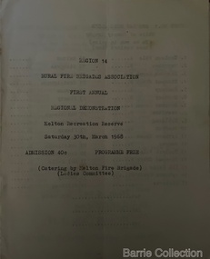
Booklet, Region 14 Rural Fire Brigades Association, 1968
Formation of the Mt Cottrell Fire Brigades Group In its policy of creating smaller compact groups of fire brigades the Country Fire Authority Regional Officer Harry Rothsay in 1967 requested that the following 6 brigades surrounding Mt Cottrell transfer from their respective groups. Melton and Rockbank from Bacchus Marsh Group, Toolern Vale and Sydenham from Mt Macedon Group and Truganina and Werribee from Little River Group forming a new Group to the be named Mt Cottrell Fire Brigades Group. Group Headquarters was established at the Ferris road residence of Melton Captain E W Bon Barrie, who was elected Group and Communications Officer of Mt Cottrell. E W (Eddie) Gillespie and Keith Watt of the Toolern Vale brigade were appointed Deputy Group Officer and Group Secretary respectivelyRegion 14 Rural Fire Brigades Association First Annual Demonstration programmeemergency services -
 Melton City Libraries
Document, Mount Cottrell Fire Brigade Group standing order and constitution, 1978
In its policy of creating smaller compact groups of fire brigades the Country Fire Authority Regional Officer Harry Rothsay in 1967 requested that the following 6 brigades surrounding Mt Cottrell transfer from their respective groups. Melton and Rockbank from Bacchus Marsh Group, Toolern Vale and Sydenham from Mt Macedon Group and Truganina and Werribee from Little River Group forming a new Group to the be named Mt Cottrell Fire Brigades Group. Group Headquarters was established at the Ferris road residence of Melton Captain E W Bon Barrie, who was elected Group and Communications Officer of Mt Cottrell. E W (Eddie) Gillespie and Keith Watt of the Toolern Vale brigade were appointed Deputy Group Officer and Group Secretary respectively. Documents from the Mount Cottrell Fire Brigade Group emergency services