Showing 144 items
matching weatherboard school
-
 Kew Historical Society Inc
Plan, Melbourne & Metropolitan Board of Works : Borough of Kew : Detail Plan No.1582, 1904
The Melbourne and Metropolitan Board of Works (MMBW) plans were produced from the 1890s to the 1950s. They were crucial to the design and development of Melbourne's sewerage and drainage system. The plans, at a scale of 40 feet to 1 inch (1:480), provide a detailed historical record of Melbourne streetscapes and environmental features. Each plan covers one or two street blocks (roughly six streets), showing details of buildings, including garden layouts and ownership boundaries, and features such as laneways, drains, bridges, parks, municipal boundaries and other prominent landmarks as they existed at the time each plan was produced. (Source: State Library of Victoria)This plan forms part of a large group of MMBW plans and maps that was donated to the Society by the Mr Poulter, City Engineer of the City of Kew in 1989. Within this collection, thirty-five hand-coloured plans, backed with linen, are of statewide significance as they include annotations that provide details of construction materials used in buildings in the first decade of the 20th century as well as additional information about land ownership and usage. The copies in the Public Record Office Victoria and the State Library of Victoria are monochrome versions which do not denote building materials so that the maps in this collection are invaluable and unique tools for researchers and heritage consultants. A number of the plans are not held in the collection of the State Library of Victoria so they have the additional attribute of rarity.Original survey plan, issued by the MMBW to a contractor with responsibility for constructing sewers in the area identified on the plan within the Borough of Kew. The plan was at some stage hand-coloured, possibly by the contractor, but more likely by officers working in the Engineering Department of the Borough and later Town, then City of Kew. The hand-coloured sections of buildings on the plan were used to denote masonry or brick constructions (pink), weatherboard constructions (yellow), and public buildings (grey). Public buildings, coloured grey on the Plan 1582 include the police station and post office, churches and schools. The earliest church school, Common School No.356 was located at the rear of the Congregational Church in Peel Street. It was constructed in 1859. The first buildings of Kew Primary School No.1075 on the other side of Peel Street were constructed in 1871. The school in 1903 only occupied a small fraction of its current site. In 1903, where the rear playground is now located, were two weatherboard and one brick villa. Trinity Grammar School was founded in 1902 and opened in the Parish Hall at the rear of Holy Trinity Anglican Church. It was not to move to its current site until 1906. The outline of the building housing the Kew Fire Brigade in the centre of the north side of Walton Street is shown but not named on the plan. Further down Pakington Street stood the two-storey Italianate mansion ‘Overton’. The home of Stanford Chapman, it was to be featured in the Imperial Institute series of bromide photographs of Victoria, Vol. 1: Homes and scenery. It was later to become a boarding house before it was later demolished.melbourne and metropolitan board of works, detail plans, maps - borough of kew, mmbw 1582, cartography -
 Kew Historical Society Inc
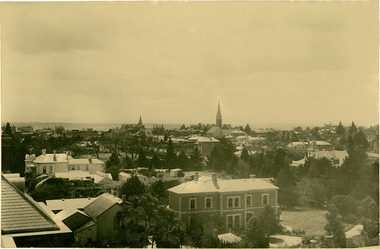
Photograph, J F C Farquhar, Bird's Eye View Looking North, 1891
At the beginning of the 1890s, the Kew businessman and Town Councillor, Henry Kellett, commissioned J.F.C. Farquhar to photograph scenes of Kew. These scenes included panoramas as well as pastoral scenes. The resulting set of twelve photographs was assembled in an album, Kew Where We Live, from which customers could select images for purchase.The preamble to the album describes that the photographs used the ‘argentic bromide’ process, now more commonly known as the gelatine silver process. This form of dry plate photography allowed for the negatives to be kept for weeks before processing, hence its value in landscape photography. The resulting images were considered to be finely grained and everlasting. Evidence of the success of Henry Kellett’s venture can be seen today, in that some of the photographs are held in national collections.It is believed that the Kew Historical Society’s copy of the Kellett album is unique and that the photographs in the book were the first copies taken from the original plates. It is the first and most important series of images produced about Kew. The individual images have proved essential in identifying buildings and places of heritage value in the district.This panoramic view was probably taken from the roof of Xavier College. It invites the viewer to look down on the buildings and streets of Kew, and across to the distant horizon. Mansions and solid bourgeois villas dominate the view of Charles and Wellington Streets. The imposing spires of the Presbyterian and Methodist Churches, built in one of the highest areas of Kew, can be seen in the distance. In the foreground, the photographer includes three significant mansions: Molina, Roxeth and Elsinore. Molina, in the foreground, and the group of weatherboard buildings in its yard was used at this stage for the privately operated ‘Kew High School’ (founded 1872). Roxeth, the home of Herbert Henty can be identified by its distinctive four-sided tower. All three buildings are now part of Trinity Grammar. Other built structures observable in the photograph include Wilton (now the Kew RSL), designed by Guyon Purchas for Dr William Walsh in 1886, and the only known image of the Prospect Hill Hotel prior to the renovation of 1935. Bird's Eye View Looking Northkew illustrated, kew where we live, photographic books, henry kellett -
 Kew Historical Society Inc
Plan, Melbourne & Metropolitan Board of Works : Borough of Kew : Detail Plan No.1563, 1905
The Melbourne and Metropolitan Board of Works (MMBW) plans were produced from the 1890s to the 1950s. They were crucial to the design and development of Melbourne's sewerage and drainage system. The plans, at a scale of 40 feet to 1 inch (1:480), provide a detailed historical record of Melbourne streetscapes and environmental features. Each plan covers one or two street blocks (roughly six streets), showing details of buildings, including garden layouts and ownership boundaries, and features such as laneways, drains, bridges, parks, municipal boundaries and other prominent landmarks as they existed at the time each plan was produced. (Source: State Library of Victoria)This plan forms part of a large group of MMBW plans and maps that was donated to the Society by the Mr Poulter, City Engineer of the City of Kew in 1989. Within this collection, thirty-five hand-coloured plans, backed with linen, are of statewide significance as they include annotations that provide details of construction materials used in buildings in the first decade of the 20th century as well as additional information about land ownership and usage. The copies in the Public Record Office Victoria and the State Library of Victoria are monochrome versions which do not denote building materials so that the maps in this collection are invaluable and unique tools for researchers and heritage consultants. A number of the plans are not held in the collection of the State Library of Victoria so they have the additional attribute of rarity.Original survey plan, issued by the MMBW to a contractor with responsibility for constructing sewers in the area identified on the plan within the Borough of Kew. The plan was at some stage hand-coloured, possibly by the contractor, but more likely by officers working in the Engineering Department of the Borough and later Town, then City of Kew. The hand-coloured sections of buildings on the plan were used to denote masonry or brick constructions (pink), weatherboard constructions (yellow), and public buildings (grey). This plan covers the area between Barkers Road, Wrixon Street, Sackville Street and Brougham Place, much of it now occupied by Carey Baptist Grammar and Preshil schools. This was an area of large and prestigious homes in 1903, some with formally laid-out gardens, such as ‘Tower Hill’ and ‘Opawa’. ‘Kalimna’ was built in 1890-91 for William H. Jarman, an accountant, and ‘Blackhall’ at the same time for W.H. Roberts. Blackhall was to be acquired by the Salvation Army in 1915 and renamed ‘Catherine Booth Girls’ Home’. The Home accommodated girls, aged between 4 and 16. Kalimna and Blackhall are of significance as typical and intact late Victorian mansions and as such are two key Victorian buildings to have been built in Kew. Both Blackhall and Kalimna are now part of Preshil. ‘Fairview’ was for a long time occupied by the Sisters of St. Joseph of Cluny as a care home for the elderly, but it is now part of Carey Grammar School, as are the grounds of ‘Wagga Merne’, ‘Weemutta’, ‘Blakely’, ‘Daheim’ and ‘Mildura’ (later ‘Urangeline’), the last being particularly impressive in 1903, with a tennis court, conservatory, outhouses, and two bathrooms!melbourne and metropolitan board of works, detail plans, mmbw 1563, cartography -
 Kew Historical Society Inc
Plan, Melbourne & Metropolitan Board of Works : Borough of Kew : Detail Plan No.1565, 1905
The Melbourne and Metropolitan Board of Works (MMBW) plans were produced from the 1890s to the 1950s. They were crucial to the design and development of Melbourne's sewerage and drainage system. The plans, at a scale of 40 feet to 1 inch (1:480), provide a detailed historical record of Melbourne streetscapes and environmental features. Each plan covers one or two street blocks (roughly six streets), showing details of buildings, including garden layouts and ownership boundaries, and features such as laneways, drains, bridges, parks, municipal boundaries and other prominent landmarks as they existed at the time each plan was produced. (Source: State Library of Victoria). This plan forms part of a large group of MMBW plans and maps that was donated to the Society by the Mr Poulter, City Engineer of the City of Kew in 1989. Within this collection, thirty-five hand-coloured plans, backed with linen, are of statewide significance as they include annotations that provide details of construction materials used in buildings in the first decade of the 20th century as well as additional information about land ownership and usage. The copies in the Public Record Office Victoria and the State Library of Victoria are monochrome versions which do not denote building materials so that the maps in this collection are invaluable and unique tools for researchers and heritage consultants. A number of the plans are not held in the collection of the State Library of Victoria so they have the additional attribute of rarity.Original survey plan, issued by the MMBW to a contractor with responsibility for constructing sewers in the area identified on the plan within the Borough of Kew. The plan was at some stage hand-coloured, possibly by the contractor, but more likely by officers working in the Engineering Department of the Borough and later Town, then City of Kew. The hand-coloured sections of buildings on the plan were used to denote masonry or brick constructions (pink), weatherboard constructions (yellow), and public buildings (grey). MMBW Plan No.1565 is an example of a plan where a number of streets have been created since the area was surveyed, or in other cases renamed. The plan shows those streets that were bordered by Ross Street, Mount Street, Sackville Street and Burke Road. Since 1905, Mawson Street has been created and Mont Albert Road renamed as Dean Street. Named houses on the plan include ‘Tyrol’, ‘Glengorse’, ‘Theodore Villa’, ‘Arncliffe’, ‘Ballynira’ and ‘Hazeldene’. The plan also shows a Wesleyan Church in Sackville Street. In 1883, the Church’s Sunday School celebrated its silver anniversary.melbourne and metropolitan board of works, detail plans, mmbw 1565, cartography -
 Kew Historical Society Inc
Plan, Melbourne & Metropolitan Board of Works : Borough of Kew : Detail Plan No.1568, 1905
The Melbourne and Metropolitan Board of Works (MMBW) plans were produced from the 1890s to the 1950s. They were crucial to the design and development of Melbourne's sewerage and drainage system. The plans, at a scale of 40 feet to 1 inch (1:480), provide a detailed historical record of Melbourne streetscapes and environmental features. Each plan covers one or two street blocks (roughly six streets), showing details of buildings, including garden layouts and ownership boundaries, and features such as laneways, drains, bridges, parks, municipal boundaries and other prominent landmarks as they existed at the time each plan was produced. (Source: State Library of Victoria)This plan forms part of a large group of MMBW plans and maps that was donated to the Society by the Mr Poulter, City Engineer of the City of Kew in 1989. Within this collection, thirty-five hand-coloured plans, backed with linen, are of statewide significance as they include annotations that provide details of construction materials used in buildings in the first decade of the 20th century as well as additional information about land ownership and usage. The copies in the Public Record Office Victoria and the State Library of Victoria are monochrome versions which do not denote building materials so that the maps in this collection are invaluable and unique tools for researchers and heritage consultants. A number of the plans are not held in the collection of the State Library of Victoria so they have the additional attribute of rarity.Original survey plan, issued by the MMBW to a contractor with responsibility for constructing sewers in the area identified on the plan within the Borough of Kew. The plan was at some stage hand-coloured, possibly by the contractor, but more likely by officers working in the Engineering Department of the Borough and later Town, then City of Kew. The hand-coloured sections of buildings on the plan were used to denote masonry or brick constructions (pink), weatherboard constructions (yellow), and public buildings (grey). Plan No.1568 covers the area bounded by Cotham Road, John Street, Sackville Street, and Edward Street. Alfred Street and Rowland Street are in shown in the middle of the plan. The two most notable buildings shown are ‘St Helliers’, the home of the Dumaresq family, and St Hilary’s Church and school. While the colours used to indicate St Hilary’s are grey as in other civic/public buildings, the first St Hilary’s Anglican Church was at this stage constructed in weatherboard. At the left of the plan, facing Sackville Street is a house named ‘Glencara’. The 1988 ‘Kew Conservation Study’ recorded that “The first documentary evidence of this house comes from Rate Books which record that in 1893 a Mrs Treadway was the owner of this building with an N.A.V. of £81? At that date the occupier of the house was Charles B. Kelly, a clerk, while by 1910 Kelly had become the owner of the property described in that year ‘as a six-roomed stone, brick and wood house with stables and outbuildings’”. Contrary to this description, the 1905 plan indicates that the house was entirely constructed of masonry.melbourne and metropolitan board of works, detail plans, mmbw 1568 -
 Kew Historical Society Inc
Plan, Melbourne & Metropolitan Board of Works : Borough of Kew : Detail Plan No.1573, 1905
The Melbourne and Metropolitan Board of Works (MMBW) plans were produced from the 1890s to the 1950s. They were crucial to the design and development of Melbourne's sewerage and drainage system. The plans, at a scale of 40 feet to 1 inch (1:480), provide a detailed historical record of Melbourne streetscapes and environmental features. Each plan covers one or two street blocks (roughly six streets), showing details of buildings, including garden layouts and ownership boundaries, and features such as laneways, drains, bridges, parks, municipal boundaries and other prominent landmarks as they existed at the time each plan was produced. (Source: State Library of Victoria)This plan forms part of a large group of MMBW plans and maps that was donated to the Society by the Mr Poulter, City Engineer of the City of Kew in 1989. Within this collection, thirty-five hand-coloured plans, backed with linen, are of statewide significance as they include annotations that provide details of construction materials used in buildings in the first decade of the 20th century as well as additional information about land ownership and usage. The copies in the Public Record Office Victoria and the State Library of Victoria are monochrome versions which do not denote building materials so that the maps in this collection are invaluable and unique tools for researchers and heritage consultants. A number of the plans are not held in the collection of the State Library of Victoria so they have the additional attribute of rarity.Original survey plan, issued by the MMBW to a contractor with responsibility for constructing sewers in the area identified on the plan within the Borough of Kew. The plan was at some stage hand-coloured, possibly by the contractor, but more likely by officers working in the Engineering Department of the Borough and later Town, then City of Kew. The hand-coloured sections of buildings on the plan were used to denote masonry or brick constructions (pink), weatherboard constructions (yellow), and public buildings (grey). This plan has detailed annotations written in red or blue ink, showing prices, which may be the annual valuations of the properties, and some owners’ names, a most unusual feature on contractor's maps. Some areas, such as the buildings of Methodist Ladies’ College (MLC), include the school’s tennis court and swimming pool, but are not coloured to show building materials – did the draftsman just run out of time, or ink, or enthusiasm, before his plan had to be submitted? MLC had been founded in 1882 as a ‘modern school of the first order’ with buildings that formed ‘a collegiate institution for girls unsurpassed in the colonies’. The goal of its founders was to provide a high-class Christian education for girls, comparable with that provided elsewhere for boys. Some shops are shown along Edgevale Road, though they are not designated as commercial premises. Larger houses are depicted, including ‘Fairlawn’ in Barkers Road, and ‘Clevedon’ and ‘Rosehill’ (now demolished) in Fitzwilliam Street.melbourne and metropolitan board of works, detail plans, mmbw 1573, maps - borough of kew, cartography -
 Kew Historical Society Inc
Plan, Melbourne & Metropolitan Board of Works : Borough of Kew : Detail Plan No.1574, 1905
The Melbourne and Metropolitan Board of Works (MMBW) plans were produced from the 1890s to the 1950s. They were crucial to the design and development of Melbourne's sewerage and drainage system. The plans, at a scale of 40 feet to 1 inch (1:480), provide a detailed historical record of Melbourne streetscapes and environmental features. Each plan covers one or two street blocks (roughly six streets), showing details of buildings, including garden layouts and ownership boundaries, and features such as laneways, drains, bridges, parks, municipal boundaries and other prominent landmarks as they existed at the time each plan was produced. (Source: State Library of Victoria)This plan forms part of a large group of MMBW plans and maps that was donated to the Society by the Mr Poulter, City Engineer of the City of Kew in 1989. Within this collection, thirty-five hand-coloured plans, backed with linen, are of statewide significance as they include annotations that provide details of construction materials used in buildings in the first decade of the 20th century as well as additional information about land ownership and usage. The copies in the Public Record Office Victoria and the State Library of Victoria are monochrome versions which do not denote building materials so that the maps in this collection are invaluable and unique tools for researchers and heritage consultants. A number of the plans are not held in the collection of the State Library of Victoria so they have the additional attribute of rarity.Original survey plan, issued by the MMBW to a contractor with responsibility for constructing sewers in the area identified on the plan within the Borough of Kew. The plan was at some stage hand-coloured, possibly by the contractor, but more likely by officers working in the Engineering Department of the Borough and later Town, then City of Kew. The hand-coloured sections of buildings on the plan were used to denote masonry or brick constructions (pink), weatherboard constructions (yellow), and public buildings (grey). This plan shows several very large houses, particularly along Glenferrie Road, and the area now occupied by Ruyton Girls’ School. ‘Tarring’ (incorrectly spelled here as ‘Karring’) was built for Henry Henty in 1872, on part of his original allotment of 20 acres, and ‘Mount View’, which retains its original building and the fountain in the front garden, is part of Ruyton’s Junior School. The most significant change to Tarring and its grounds since 1903, involve the removal of a number of the outbuildings, including a Burmese temple, bought by Henty from the Burmese Exhibit at the Great Exhibition of 1880. It is shown on the plan as a summerhouse. The two-storey mansion, on the corner of Glenferrie Road and Wellington Street, was built in 1891 by leading architect Alfred White as his own home. Having an initial N.A.V. of £160, the house was purchased by a warehouseman Henry Lister, by 1900, when the N.A.V. was recorded at £111. By the turn of the century the house was known as ‘Comaques’. By contrast, much smaller houses are shown in Scott and Byron Streets, including a tiny Mission Hall in Byron Street, which belonged to the Anglican Church from at least 1903 to 1917.melbourne and metropolitan board of works, detail plans, maps - borough of kew, mmbw 1574, cartography -
 Sunbury Family History and Heritage Society Inc.
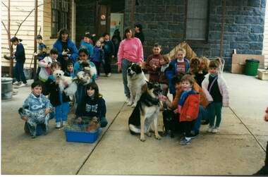
Photograph, Bulla Primary School - Pets Day
The children are gathered in the courtyard at the former Bulla Primary School with two adults and their pets to celebrate the school's Pets Awareness Day. Jenny Patty and Sue Murphy are the two adults. Bulla Primary used to run a number of extra-curricular programs at the school that also involved the local community.A coloured photograph of two adults standing in a sheltered outdoor area at a school with the children, many of whom are holding small animals. A blue stone building and a cream painted weatherboard building are partly visible in the background. pets awareness day, bulla primary school, jenny patty, sue murphy -
 Sunbury Family History and Heritage Society Inc.
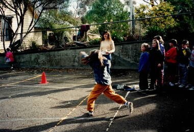
Photograph, Sports Day, c1994
When the photograph was taken, the Bulla Primary School was running a sports day for the students at the school. The event took place in the school grounds and parents were invited to attend. The sports day was part of the children's physical education program where they became familiar with various sports skills and events. A non-digital coloured photograph of children lined up on the side of a netball court with an adult with one girl setting off on the start of a relay race. A cream weatherboard building is in the background.The photograph was taken before the advent of digital cameras so the photograph would have been developed from a film.bulla primary school, sports day -
 Sunbury Family History and Heritage Society Inc.
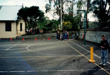
Photograph, Bulla Primary School - Outdoor area, c1994
The photograph was taken when the school was conducting its sports day when all the students were taught various sporting skills that were included in inter-school sports. he program took place within the school grounds and parents were invited to attend the day.This was one of the events when both the school and the local community were involved on the day.A coloured pre-digital photograph of a section of the former Bulla Primary School outdoor area with a partial view of the cream weatherboard classroom to the left of the image. Some of the children are involved in sporting activities on the netball court in the foreground. The photograph was taken before digital cameras were used.bulla primary school, sports day -
 Sunbury Family History and Heritage Society Inc.
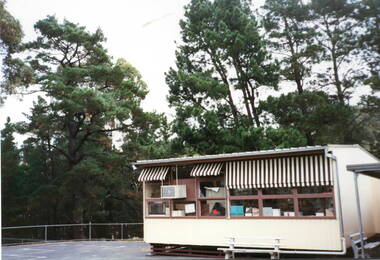
Photograph, Bulla Primary School - Portable classroom, c1990s
The building was one of the classrooms brought to the Bulla Primary School in the early 1990s to accommodate the increased school enrolments. These rooms were easily transportable and were uses extensively in Victorian Government schools from the early 1950s onwards to cope with growing school attendances. A non-digital photograph of a weatherboard building with a low pitched metal roof and brown and white striped sun-blinds erected in an open ground with tall conifer trees in the background.bulla primary school, portable classrooms -
 Sunbury Family History and Heritage Society Inc.
Photograph, Bulla Primary School, C1993
The building photographed was one of the buildings erected on the former Bulla Primary School site. The original classroom was a bluestone construction and other weatherboard buildings were added as the school enrolment increased over the years.A non-digital coloured photograph of a classroom at the former Bulla Primary School.bulla primary school, school buildings. -
 Sunbury Family History and Heritage Society Inc.
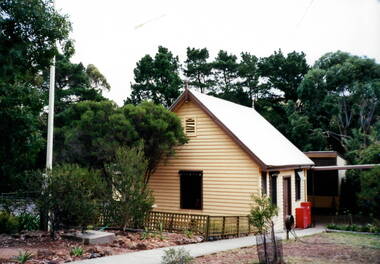
Photograph, Bulla Primary School, c1993
The weatherboard building was one of three erected in the former Bulla Primary School grounds. The original school building was constructed from bluestone as was the case with many other buildings in the district. A non-digital coloured photograph of a cream weatherboard building with brown trims. There are tall conifers and gum trees trees in the background and a concrete pathway leading to the building's front door.bulla primary school, school buildings -
 Sunbury Family History and Heritage Society Inc.
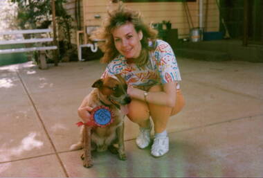
Photograph, Bulla Primary School - Pets Day, 1988
Bulla Primary School held a pets day at the school in 1988 and the students, teachers and parents along with their pets were invited to participate. Jenny Wilson who was a teacher at the school at the time brought along g her dog which won the championship prize.By holding a pets day at the school and involving the school and community, the children gained an understanding of the benefits and importance of caring for pets.A non-digital coloured photograph of a lady in an outdoor area with her dog that has a prize winning rosette attached to its collar. A weatherboard building is partly visible in the background.bulla primary school - pets'day., jenny wilson, pets -
 Sunbury Family History and Heritage Society Inc.
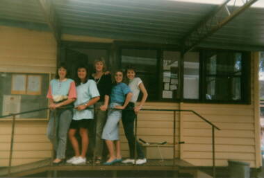
Photograph, December 1988
The five women photographed were staff members at Bulla Primary School in 1988. They are from L-R: Sue Bradley, grades 2/3 teacher, Ivy Grant, music teacher, Carol Hitchens, grades 4-6 teacher and principal, Kim Barber, integration aide and Jenny Wilson, grades Prep and 1 teacher. The photograph was taken at the end of the school year on 'break-up' day. This is a visual record of the school staff who were employed at Bulla primary School in December 1988.A coloured non-digital photograph of five ladies standing in a covered area, on a landing outside a weatherboard building.bulla primary school, sue bradley, ivy grant, carol hitchens, jenny wilson, kim barber -
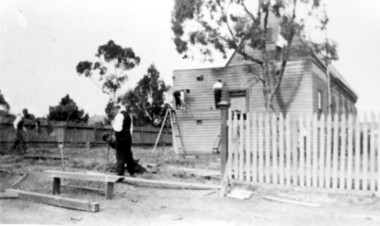
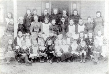 Stawell Historical Society Inc
Photograph, Private School Teachers & Students on verandah of a weatherboard building
Private School Students and teachers on verandah of weatherboard building.stawell education -
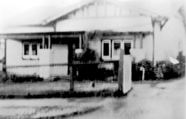 Surrey Hills Historical Society Collection
Photograph, 7 Sunbury Crescent
7 Sunbury Crescent was the home of Mr and Mrs Albert Tacey, associated with the Tacey family butchers at 629 Canterbury Road from 1888 – 1950s. Lucy Myra (MS Sparkes) was the wife of Albert Arthur Tacey (1902-1959) who worked in the family butchers business from the time he left school at 14 until 1952. They bought their Sunbury Crescent home at the time of their marriage in 1923 and had 3 surviving children – Elaine Merle, Frank Newman and Donald Arthur. Courtesy: Mrs Elaine McKenzie, nee Tacey, their daughter.A black and white photograph of a weatherboard Californian Bungalow style home. A wire fence is across the front. The photo is very out of focus.(mr) albert tacey, sunbury crescent, surrey hills, butchers, 1923, californian bungalow, weatherboard, (mrs) lucy tacey, (miss) lucy sparkes, (mr) frank newman tacey, (miss) elaine merle tacey, (mr) donald arthur tacey -
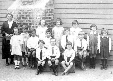 Surrey Hills Historical Society Collection
Photograph, Miss Susan Kelsall's school, Canterbury Road, Surrey Hills, 1925
Date is approximate. The teacher is presumed to be Miss Susan Kelsall; 3 of the children are identified as: Back row left: Thora Holmes Back row right: Gwen Evans and Betty Austin. Miss Kelsall was registered as a primary and music teacher in 1908. In 1919 she had a school at Wyclif Church in Norfolk Road. From 1924-1930 the school was in the hall, perhaps built for her, at 426 Canterbury Road, just west of Warrigal Road. This was demolished in 1985; a gum tree marked the spot.Black and white photo of a teacher holding a book and 3 rows of children in front of a weatherboard wall with a brick chimney protruding from the wall. The children are not in uniform although a couple of the girls are wearing tunics and all the boys are wearing ties. independent schools, schools, primary education, music, miss susan kelsall, miss gwen evans, miss betty austin, miss thora holmes, mrs betty harvey -
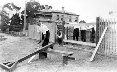 Surrey Hills Historical Society Collection
Photograph, St George's Church of England, Mont Albert working bee, early 1923 (2), 1923
The foundation stone for St George's Church of England, Mont Albert was laid in 1886 on land donated by Edward Dyer and the first service was preached in January 1887. From 1904 until 1907 it was known as Holy Trinity, Surrey Hills. The original church was weatherboard and replaced by a brick one in the Gothic Revival style which was designed by local architect George J V Blackburne, who also designed the Wesleyan School at Surrey Hills. The building was partly funded by donations, profits from a bazaar and concert, and other people donated furnishings. The church had boundaries along Mont Albert Road and St Georges Road. In 1998 the Church was sold and converted into a complex of units. Its current address is 19 St Georges Avenue, Mont Albert. The purpose of this working bee in 1923 was to close up the double gateway, which in earlier times had been used for entry of by horse-drawn vehicles to the church grounds. 'Lugano' was built in 1893 for William Wilson, a prominent stonemason and importer of marble fireplaces. In 1903 it became the home of William Holmes who was Chief Electrical Engineer for the Victorian Railways. He designed the electrification of the Melbourne suburban network. 'Lugano' stayed in the Holmes family until the 1930s. Norman Carter took many photos of Surrey Hills and Mont Albert from the 1920s in particular of events and activities associated with the Church of England.Black and white photo of 6 men behind and in front of a picket fence, a section of which has posts and railings only. In front of the fence is a wide grassy verge on which a bench is set up for cutting lengths of wood. A large Victorian house ('Lugano') can be seen in the background and a lamp post with a street sign. Beyond the house are mature eucalyptus trees.churches, holy trinity church, anglican church, st george's anglican church, working bees, lugano, william holmes, william wilson, norman brodley carter -
 Surrey Hills Historical Society Collection
Photograph, St George's Church of England, Mont Albert working bee, early 1923 (1), 1923
The foundation stone for St George's Church of England, Mont Albert was laid in 1886 on land donated by Edward Dyer and the first service was preached in January 1887. From 1904 until 1907 it was known as Holy Trinity, Surrey Hills. The original church was weatherboard and replaced by a brick one in the Gothic Revival style which was designed by local architect George J V Blackburne, who also designed the Wesleyan School at Surrey Hills. The building was partly funded by donations, profits from a bazaar and concert, and other people donated furnishings. The church had boundaries along Mont Albert Road and St Georges Road. In 1998 the Church was sold and converted into a complex of units. Its current address is 19 St Georges Avenue, Mont Albert. Norman Carter took many photos of Surrey Hills and Mont Albert from the 1920s, in particular of events and activities associated with the Church of England.Black and white photo of 4 men at a working bee in the grounds of St George's Anglican Church in Mont Albert. Two men are on a scaffold working on the weatherboards of the church; the other two are working on fencing. One boundary is marked with a paling fence; the other has a section of picket fencing and a large open section with no fencing. There is a mature eucalyptus tree in front of the church; others are beyond the paling boundary fence. The church itself is a simply constructed weatherboard building.churches, holy trinity church, anglican church, st george's anglican church, working bees, norman brodley carter -
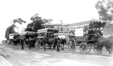 Surrey Hills Historical Society Collection
Photograph, Preparing to leave for the St George's Church of England Sunday School picnic, Mont Albert Road, 1922, 1922
The drags would have been leaving St George's Church of England in Mont Albert Road. The foundation stone for St George's Church of England, Mont Albert was laid in 1886 on land donated by Edward Dyer and the first service was preached in January 1887. From 1904 until 1907 it was known as Holy Trinity, Surrey Hills. The original church was weatherboard and replaced by a brick one in the Gothic Revival style which was designed by local architect George J V Blackburne, who also designed the Wesleyan School at Surrey Hills. The building was partly funded by donations, profits from a bazaar and concert, and other people donated furnishings. The church had boundaries along Mont Albert Road and St Georges Road. In 1998 the Church was sold and converted into a complex of units. Its current address is 19 St Georges Avenue, Mont Albert. The annual Sunday School picnic was held at Hampton and drags were the usual mode of transport. 'Lugano' was built in 1893 for William Wilson, a prominent stonemason and importer of marble fireplaces. In 1903 it became the home of William Holmes who was Chief Electrical Engineer for the Victorian Railways. He designed the electrification of the Melbourne suburban network. 'Lugano' stayed in the Holmes family until the 1930s. The annual Sunday School picnic was held at at a variety of locations and drags were the usual mode of transport. Donor information is that this was taken as the congregation prepared to depart for at Hampton on the picnic held on 25/2/1922. There are 2 copies: the original donated print and an enlargement. The original was mounted on card with photo mounts along with 506, 871, 872, and 873. It measures 13 cm x 9 cm.Black and white photo of 4 'drags' (horse-drawn hooded carriages) lined up in Mont Albert Road near the corner of St George's Avenue, in readiness for departure for the Sunday School picnic. The carriages are loaded with people and decorated with flags. The front carriage has a material sign attached to the side; the top line of writing is not decipherable, but the bottom one reads "SURREY HILLS". Four men stand in the road, which has bluestone curb and channelling. In the background is 'Lugano'.On rear in ink: "S.S. picnic to Hampton / 25th. Feb. 1922" and in a different hand in biro: "At Mont Albert. St George's Church"churches, holy trinity church, anglican church, sunday schools, picnics, lugano, horse-drawn vehicles, william wilson, willaim holmes, st george's church of england, mont albert, mont albert road -
 Surrey Hills Historical Society Collection
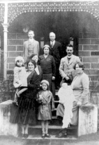
Photograph, Charles Henry Maling and family at 'The Willows', Shepreth Street, Surrey Hills (demolished), 1930s
“The Willows” home of John Butler Maling on south side of Whitehorse Road in Shepreth Street, near Banool Road. He built 2-roomed mud brick cottage in about 1861 extending it in stages into a weatherboard Victorian villa as his family grew. John Butler Maling's uncle (also John Butler Maling lived nearby at 'Ancyra' at 26 Weybridge Street). 'The Willows' was situated on a small farm of c13 acres with a creek running through it, lined with willows. The house was demolished after J B Maling's death in 1931 when the land was subdivided, some of it having been previously bought by the Education Department for the site of Chatham Primary School. J B Maling trained his six sons as builders. Charles Henry and his family are pictured in this photo. Charles Henry Maling (1875-1953) married Katherine Mitchell (1875-1958) in 1901. They lived at 9 Benson Street, Surrey Hills but came to live at 'The Willows' for 5 years prior to 1931 to care for Charles' father. Charles and Katherine are the older man and woman centre back with daughter Ellen Grace, known as Nell (1882-1960) in the front of them. Right front seated on the pillar is daughter Jane Emma (1872-1980) with her baby. Her husband Robert Wilhelm (Bob) Sutherland is the younger man at the back. The occasion is thought to be the christening of their first child. The other people are Rev O Cordell, his wife Mary and their children who are friends visiting from Africa where the donor, Rev Charles Maling, son of Charles Henry Maling was working with the Church Mission Society. A black and white photograph of a group of people standing (one lady sitting) on the front steps of a house.the willows, house names, (mr) john butler maling, whitehorse road, banool road, balwyn, surrey hills, (mr) charles henry maling, (mrs) katherine maling, (miss) nell maling, (mrs) jane sutherland, (mr) bob sutherland, (rev) o cordell, (mrs) mary cordell -
 Surrey Hills Historical Society Collection
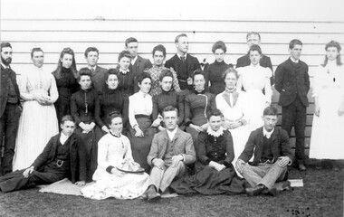
Photograph, Surrey Hills Wesleyan Sunday School teachers, Before 1888
Donor identification was that man in back row on left was Henry Beckett; 2nd from left was Emma Beckett, later Mrs John Gray. The Beckett family were important in the establishment of the Wesleyan / Methodist church in Surrey Hills and adjacent areas. Emma Beckett married John Gray in 1888 at 'Guildford Villa' in Essex Road, Surrey Hills which was the Beckett family home.B&W photo of a group of 15 women and 9 men standing and seated in front of a light-coloured weatherboard wall. surrey hills wesleyan sunday school, surrey hills wesleyan church, surrey hills methodist church, churches, (mr) henry beckett, (miss) emma beckett, (mrs) john gray, beckett family -
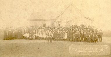 Port Fairy Historical Society Museum and Archives
Photograph, J Davis photographer, Queens Jubilee Celebration 1887, 1887
School children celebrating Queen Victoria’s Jubilee Celebration 1887 at Yambuck two children in front dressed in army uniformSepia Photograph of Weatherboard building with children posed in front celebrating Queen Victoria’s Jubilee Celebration 1887"Queens Jubilee Celebration 21.6.1887 Yambuck"events, civil, celebration, queens jubilee, yambuk, queen victoria, school children, school -
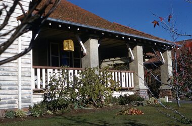 Surrey Hills Historical Society Collection
Photograph - Digital photograph, George L Coop, 688 Whitehorse Road, Mont Albert 1958, 1958
The donor George Lister Coop was about 21 years of age when he took this photo in 1958 of his family home. His parents were George Burton Coop (b c1906 Williamstown; died aged 54 years at Mont Albert) and Winsome Alice (MS: Trewartha) who married in 1936. They are first listed at this address in the electoral roll in 1937. They had 2 children: George Lister Coop - born St Georges Hospital, 8/10/1937 and Alison - born c1945. However the donor informed that he initially attended Chatham State School because his first home was the Spanish Mission style flats at 346 Whitehorse Road, opposite Brenbeal Street, Balwyn. When his grandparents died, the family moved to 688 Whitehorse Road and he then attended Mont Albert Central School. Alison being younger did not go to Chatham Primary. A digital copy of a colour photo showing detail of the front veranda of 688 Whitehorse Road. The house is white weatherboard in a modified Californian bungalow style with a tiled roof and the carport built within the roofline. The balustrades and finials of the veranda are simple with occasional feature planks with a tulip detail. A bird cage hangs from the veranda. The veranda is supported by rough-cast sturdy pillars.george l coop, whitehorse road, mont albert, uniting church, californian bungalow -
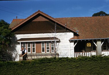 Surrey Hills Historical Society Collection
Photograph - Digital photograph, George L Coop, 688 Whitehorse Road, Mont Albert 1958, 1958
The gentleman in the photo is George Burton Coop, an architect / draughtsman. The donor, his son George Lister Coop was about 21 years of age when he took this photo in 1958 of his family home. His parents were: George Burton Coop (b c1906 Williamstown; died aged 54 years at Mont Albert) and Winsome Alice (MS: Trewartha) who married in 1936. They are first listed at this address in the electoral roll in 1937. They had 2 children: George Lister Coop - born St Georges Hospital, 8/10/1937 and Alison - born c1945. However the donor informed that he initially attended Chatham State School because his first home was the Spanish Mission style flats at 346 Whitehorse Road, opposite Brenbeal Street, Balwyn. When his grandparents died, the family moved to 688 Whitehorse Road and he then attended Mont Albert Central School. Alison being younger did not go to Chatham Primary. A digital copy of a colour photo showing detail of the front view of 688 Whitehorse Road. The house is white weatherboard in a Californian bungalow style with a tiled roof and shingles detail in a dark brown stain. The balustrades and finials of the veranda are simple with occasional feature planks with a tulip detail. A bird cage hangs from the veranda. The veranda is supported by rough-cast sturdy pillars. The house sits behind a cypress hedge. The photo was taken in winter as deciduous shrubs are bare. A gentleman astride a ladder is pruning the hedge. george l coop, whitehorse road, mont albert, californian bungalow, cypress hedge, gardening, george burton coop -
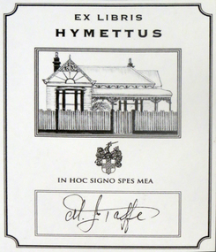 Federation University Art Collection
Work on paper - Bookplate, 'Ex Libris Hymettus' bookplate
After a quiet period, interest in bookplates in Australia began to increase in the early 1970s, Entrepreneurial art and book collectors such as Edwin Jewell and others commissioned multiple Bookplate designs from a range of well known fine artists. At a 1997 meeting in Melbourne of the Ephemera Society of Australia Edwin Jewell and others announced the formation of the Australian Bookplate Society. The society was instrumental in promoting the art of the bookplate through establishment of the Australian Bookplate Design competition. The competition includes a design award for secondary schools students.Bookplate depicts a weatherboard cottage behind a paling fence.Signature incorporated within platebookplate, printmaking, hymettus cottage, ballarat, michael taffe -
 Port Fairy Historical Society Museum and Archives
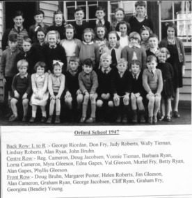
Photograph, 1947
... Black and white photograph of a group of school children... Street Port Fairy great-ocean-road Pupils of Orford school 1947 ...Pupils of Orford school 1947 all namedBlack and white photograph of a group of school children outside weatherboard building with names added underneathOrford School 1947. Back Row.- L to R.- George Riordan, Don Fry, Judy Roberts, Wally Tieman, Lindsay Roberts, Alan Ryan, John Bruin, Centre Row.- Reg Cameron, Doug Jacobsen, Vonnie Tieman, Barbara Ryan, Lorna Cameron, Myra Gleeson, Edna Gapes, Val Gleeson, Muriel Fry, Betty Ryan, Alan Gapes, Phyllis Gleeson. Front Row.- Doug Bruin, Margaret Porter, Helen Roberts, Jim Gleeson, Alan Cameron, George Jacobsen, Cliff Ryan, Graham Fry, Georgina (Beadie) Youngorford, school, pupils, students -
 Federation University Historical Collection
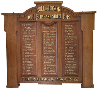
Furniture - Object, Burnbank Street Methodist Sunday School Honor Board
This honour board is thought to have been made to a design by a student of the Ballarat Technical Art School, a division of the Ballarat School of Mines. "Honor Boards. — During the past few months very many honor boards have been manufactured by Messrs R. Tunbridge and Sons, and their handsome design and workmanship have given complete satisfaction to purchasers. Some time ago, the firm gave five guineas, for prizes to the architectural class at the School of Mines for the best honor board designs, and some magnificent suggestions were submitted by the competitors. Messrs Tunbridge and Sons, in adopting this plan, gave encouragement to the students to develop along the lines of originality in architecture, and at the same time secure a very fine collection of designs. The whole of the honor boards turned out by the firm are of local manufacture and only the very choicest of Australian timbers are used. As Tunbridge and Sons have made the manufacture of honor boards a speciality they are employing a couple of first-class cabinetmakers on the work of making honor hoards only, and the lettering is also done by a local firm. An honor board which has just been completed by Tunbridge and Sons is at present on view in the firm's window facing Sturt street. It is for Holy Trinity Church, Stawell, is manufactured from Queensland maple, beautifully grained, and is of handsome gothic design. This honor Board is 8 feet in height, and measures 5 feet 6 inches across, and it contains 142 names, including 10 heroes who have won distinctions, and 37 soldiers who have made the supreme sacrifice. Tunbridge and Sons have manufactured honor boards for Miners' Rest:, Weatherboard, Scotchman's Lead, Durham lead, the Buninyong Methodist Church, Ballarat Shire south riding, St. Arnaud High School, Knox Sunday School, and Bungaree Shire Council, and there are boards for the Watchem South State School, and Springdallah in hand. People are realising that there is no need to go to Melbourne for honor boards, which are manufactured by Tunbridge and Sons of superior material, and are better finished and their prices are much below metropolitan rates." (Ballarat Star, 27 April 1918) Geoffrey Blainey's father was the pastor at the Burnbank Methodist church. Geoffrey Blainey became the first Chancellor of the University of Ballarat, a predecessor of Federation University Australia. The Honour Board was removed from the Wendouree Uniting Church when it was closed on August November 2019. Timber honour board for the Burnbank Methodist Church in Ballarat.burnbank street methodist sunday school honor board, world war one, honour board, honor board, wendouree uniting church -
 Bendigo Historical Society Inc.
Photograph - T C WATTS & SON COLLECTION: WHITE HILLS, NEXT TO CATHOLIC SCHOOL, 1927
BHS CollectionBlack and white photograph mounted on rectangular brown board. House, weatherboard , triple gabled corrugated iron roof, single chimney , wooden return verandah with balustrade, capitals to verandah posts. Exterior windows have awnings, two entrances from returned verandah, two deckchairs and hammock on verandah. Rock-bordered garden R.H. corner. Written on back of photo ' Roberts, White Hills, £1150 (crossed out) £850, next R.C. School'F.A. Jeffree, Bendigoresidential, roberts, white hills, t.c. watts and son, 1927