Showing 1537 items
matching ed ?
-
 Glen Eira Historical Society
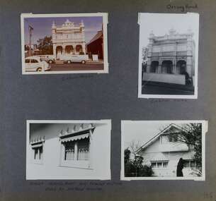
Album - Album page, Orrong Road, Circa 1972
This photograph is part of the Caulfield Historical Album 1972. This album was created in approximately 1972 as part of a project by the Caulfield Historical Society to assist in identifying buildings worthy of preservation. The album is related to a Survey the Caulfield Historical Society developed in collaboration with the National Trust of Australia (Victoria) and Caulfield City Council to identify historic buildings within the City of Caulfield that warranted the protection of a National Trust Classification. Principal photographer thought to be Trevor Hart, member of Caulfield Historical Society. Most photographs were taken between 1966-1972 with a small number of photographs being older and from unknown sources. All photographs are black and white except where stated, with 386 photographs over 198 pages.Victorian Heritage Database https://vhd.heritagecouncil.vic.gov.au/places/35576 No. 70 Orrong Road is important as an exceptionally ornate Boom style villa residence in the terraced form and in this respect is rare in Caulfield. Its architectural value is enhanced by its intact state and by the manner in which its bold architectural expression is carried through into the hallway and staircase. Victorian Heritage Database - National Trust local significance 284 Orrong Road Caulfield https://vhd.heritagecouncil.vic.gov.au/places/65700 A house designed by Harold Desbrowe Annear in 1917 and believed to have been the first "all electric" house in Melbourne. It has been extensively altered.Page 164 - four photographs of 2 different houses on Orrong Road. The top left photo is in colour while the others are in black and white.Handwritten: Orrong Road [top right] / Lisborn House [ (ed. correct name is LISBON HOUSE), under top left photo] / Lisborn House [under top right photo] / [under bottom right photo] / CORNER ORRONG ROAD AND PEARSON AVENUE / HOUSE BY DESBROWE ANNEAR [under bottom left photo] / 164 [bottom right]trevor hart, orrong road, lisbon house, lisborn house, elsternwick, pearson grove, st kilda east, caulfield north, terrace houses, cast iron work, verandahs, balconies, parapets, arches, cars, streetscapes, attic houses, desbrowe annear -
 Mont De Lancey
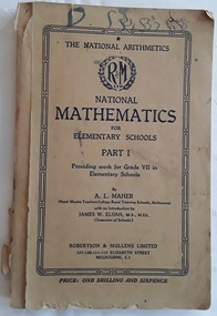
Book, A.L. Maher, National Mathematics for Elementary Schools Part 1, 1937
A National Mathematics textbook for Grade V11 in Elementary Schools Part 1 with lessons, diagrams, charts and examples of workings for students.Beige coloured paperback textbook National Mathematics for Elementary Schools Part 1 Providing work for Grade V11 in Elementary Schools. The title is written in black lettering below the round symbol for the publisher R&M - Robertson and Mullins Ltd. The author A.L. Maher (Head Master Teachers College Rural Training Schools, Melbourne) along with the Introduction written by James. W. Elijah, M.A., M. Ed. (Inspector of Schools) is printed on the cover too. There are lessons, diagrams, charts and tables. On tha back cover is a list of The National Series of School Books. 170p. The covers are torn and marked.non-fictionA National Mathematics textbook for Grade V11 in Elementary Schools Part 1 with lessons, diagrams, charts and examples of workings for students.mathematics, schools -
 Rutherglen Historical Society
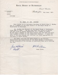
Letter, 1971
Letter accompanies the Official handbook of Rutherglen Scotland, 1970 edition, which would have been presented to a relative of the donor when John F. MacKay, a member of the Town Council of the Royal Burgh of Rutherglen in Scotland, was visiting his son in Australia.Letter of introduction, written on letterhead paper of the Royal Burgh of Rutherglen, with their coat of arms embossed on the top left corner.Letter is to introduce John F. MacKay, on the occasion of his visit to Australia, is dated 9th June, 1971, and is signed by James Hutchinson, Provost, and R.M. OSullivan, Town Clerk.rutherglen scotland, royal burgh of rutherglen, john mackay -
 Rutherglen Historical Society
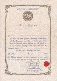
Certificate, 1973
One of the items which would have been presented to a relative of the donor when he was visiting Rutherglen Scotland in 1974.Decorative certificate, printed in blue and gold on textured paper, from the President, Councillors & Ratepayers of the Shire of Rutherglen. Space for the name of the recipient of the "Honorary Citizenship of the Township and Shire of Rutherglen" has been left blank as has the month and day of 1973 for the presentation.At the bottom of the certificate, there is an illegible signature above the words "Accredited Citizen of the Township and Shire of Rutherglen", along with a small red seal. rutherglen scotland, royal burgh of rutherglen -
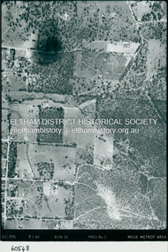 Eltham District Historical Society Inc
Photograph - Aerial Photograph, Landata, Eltham, Luck St; Bible St to Beard St, Dec. 1945
Centred on present day Eltham East Primary School, east of Main Rd along Luck St to Beard St Historic Aerial Imagery Source: Landata.vic.gov.au Aerial Photo Details: Project No :5 Project : MELBOURNE AND METROPOLITAN AREA PROJECT Run : 36 Frame : 60548 Date : 12/1945 Film Type : B/W Camera : EAG4 Flying Height : 10200 Scale : 6000 Film Number : 195 GDA2020 : 37°42'46"S, 145°09'18"E MGA2020 : 337371, 5824456 (55) Melways : 22 A4 (ed. 42)aerial photo, eltham, arthur street, beard street, bible street, eltham east primary school, frank street, henry street, luck street, stanley avenue, wycliffe crescent, neil webster collection -
 Eltham District Historical Society Inc
Photograph - Aerial Photograph, Landata, Eltham, Main Rd; Railway Rd to Zig Zag Rd, Dec. 1945
Centred on present day Edendale Farm from Glen Park rd to Zig Zag Rd Historic Aerial Imagery Source: Landata.vic.gov.au Aerial Photo Details: Project No :5 Project : MELBOURNE AND METROPOLITAN AREA PROJECT Run : 37 Frame : 60549 Date : 12/1945 Film Type : B/W Camera : EAG4 Flying Height : 10200 Scale : 6000 Film Number : 196 GDA2020 : 37°42'12"S, 145°09'09"E MGA2020 : 337141, 5825486 (55) Melways : 21 K2 (ed. 42)aerial photo, eltham, edendale farm, eltham - yarra glen road, eltham-hurstbridge railway line, gastons homestead, gastons road, glen park road, main road, park road, railway road, wattletree road, zig zag road, neil webster collection -
 Vision Australia
Document - Text, Guide to the Contracting of Words
Contractions are used in Braille to allow reduce the amount of space that a word occupies on the page, whilst still maintaining the ease of reading. In list this, a series of words with their common contractions helps the reader to use them. For example: the word atone, in this list, would be spelt with an 'a' and 't', then the contraction for 'one' would be used. In some instances, two contractions are listed, which the reader identifies by the use of a slash between them. For example: demented is 'd' then 'e', then 'ment' and a second contraction of 'ed'. The origin of this list is unknown, however has been designated as the Braille and Talking Book Library.4 pages of typewritten words with contraction notesbraille, transcription -
 Vision Australia
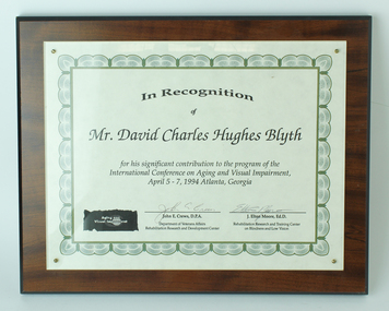
Photograph (Item), 1994 International Conference on Aging and Vision Impairment plaque presented to David Blyth
Presentation to David Blyth for his significant contribution to the conference.In Recognition of Mr David Charles Hughes Blyth for this significant contribution to the program of the International Conference on Aging and Visual Impairment, April 5-7, 1994, Atlanta, Georgia. John E Crews, D.P.A., Department of Veterans Affairs, Rehabilitation Research and Development Center J. Elton Moore, Ed. D., Rehabilitation Research and Training Center on Blindness and Low Visiondavid blyth, awards -
 Melbourne Legacy
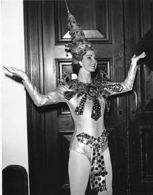
Photograph, Annual Demonstration, 1965
This photo provides just one example of the beautiful costumes worn by Junior Legacy girls for Legacy's Annual Demonstrations at the Melbourne Town Hall. Throughout the year Melbourne Legacy provided classes for Junior Legatees such as dancing, gymnastics and eurythmics, the Demonstration was an annual event to showcase their skills. Melbourne Legacy conducted Annual Demonstrations / Parades from 1928 through to the late 1970's, usually held at Melbourne Town Hall or Olympic Pool Stadium. The beautiful costumes were made by members of the Junior Legacy Mothers' Club and the Melbourne Legacy Wives' Association. Whilst the cost to Legacy was very small, the quality of the work produced was truly professional.This photo serves as photographic evidence of the work that the Legacy Wives' Association and Junior Legacy Mothers' Club produced over the years.Black and white photo of a young performer dressed in an elaborate costume and hat.Stamped on the back of the photo: "THE PROPERTY OF MELBOURNE LEGACY", "Leslie Thompson / 8 KEYSTONE CRES. / EAST KEW / WL 3078" Written on the back of the photo: "All costumes are made by the children's mothers. Annual phys. ed. classes at Melb Town Hall. Judith Bishop - Junior Legatee Melb. L's 1965 Annual demo. at Melb. Town Hall."junior legatee, annual demonstration, costumes -
 Bendigo Military Museum
Album - ALBUM, LETTERS WW2, C.WW2
Herbert Trangmar Allan, refer Cat No 2755.4 for his extensive service records and awards.Pink, hard cover photo album used as a holder to display letters. .1) Letter from C in C Gen HQ Melbourne, 17.4.1942. From Gen BLAMEY to Major H T ALLAN 2/17 AIF. .2) MID Certificate dated 30.12.1941. Major H T ALLAN M C. .3) Letter dated 24.12.1944 from HQ 1Aust Corps to 'Blue' from 'Morshead'. .4) Letter dated 18.4.1946 from OIC NSW Echelon & Records to Mrs G M ALLAN, Bellevue, NSW, notifying her of Award of Mention in Despatches. It refers to NX12229 Lt Col Herbert Trangmar ALLAN HQ 5 Base Sub Area. .5) Letter dated 14.4.1945 from OIC NSW Echelon & Records to Mrs G M ALLAN notifying her of Award of Mention in Despatches. It refers to NX12229 Major T/Col Herbert Trangmar ALLAN, Finschhafen Base Sub Area. .6) Newspaper cutting titled Many NSW Men Receive Bravery Awards. Up to 31.3.1944. Marked down near bottom of the cutting is MID for T/LT Colonel H T ALLAN OBE MC ED. .7) Memo dated 11.1944 from 5 Aust Base Sub Area. Cover note for Record of Service for NX12229 Lt/Col H T ALLAN 5 Aust Base Sub Area. .8) Letter dated 2.8.1942 from NSW L of C Area Sydney to Mrs G M ALLAN Bellevue, NSW, notifying her of MID for Maj H T ALLAN MC NX12229 for his services 2.1941 - 7.1941. Signed by Lt Col H J Bennett. .9) Letter dated 14.4.1945 from OIC NSW Echelon & Records, Sydney to NX12229 Lt Col H T ALLAN HQ 5 Aust Base Sub Area. Aust Honours & Awards. MID. .10) Letter 7.12.1950 from HQ Eastern Command Vic Barracks Paddington to Col H T ALLAN OBE MC ED R of O. Watsons Bay re Change of address to 2MD. .11) Memo dated 28.12.1944 from HQ 1st Army AIF to 5 Aust Base Sub Area re Confirmation of Promotion of NX12229 Major H T ALLAN to Lt Colonel. .12) MID Certificate dated 15.3.1945 for Maj CT / LT Col H T ALLAN OBE MC ED Finschhafen Base Sub Area. .13) MID Certificate dated 19.7.1945 for Major CT / LT Col H T ALLAN OBE MC ED, Finschhafen Base Sub Area. .14) MID Certificate dated 21.2.1946 for LT Col H T ALLAN OBE MC ED, HQ 5 Aust Base Sub Area. .15) Letter. Letterhead is of Parliament of the Commonwealth Federal Members Rooms, Sydney, dated 1.12.1941. To: Dear Mr Allan. From: W M Hughes. Handwritten on 3 sheets of paper using 4 sides. Subject matters such as fighting, AIF, loss of HMAS Sydney, the Russian front. .16) Letter & envelope. Letter: Dated 18.4.? Letterhead: Guards Club Brook St W1. To: Dear ALLAN From: BIRDWOOD of ANZAC. Subject: Their friendship - then they have to deal with 'loathsome Japs & Germans'. Envelope. OHMS, 2-1/2 penny stamp. To: Major H T ALLAN MC & OBE AMF. C/o Defence Dept Melb, Australia. On the bottom is signature of BIRDWOOD M. Readdressed to C/o 9th Div HQ Abroad. Envelope rear is franked: PO 3D JE 42. .17) Memo dated 18.6.1946. From: HQ 8MB. To: H/Col H T ALLAN ANG PcB Rabaul. Releaes of NX12229 Lt Col (T/Col) H T ALLAN OBE MC. Posted to Retired list 7.5.1946. .18) Memo dated 6.11.1946. From: OIC, 2nn Echelon AHQ. AMF. To: Lt Col H T ALLAN OBE MC ED. C/- Mrs G M ALLAN, Queens Club, King St. Sydney NSW. .19) Letter dated 8.8.1941. Letterhead of Minister for the Navy. To: Dear Major ALLAN. From: W HUGHES. Subject: All facets of WWII to date & prospective war with Japan. .20) Memo dated 31.8.1945. From: AMF OIC NSW Echelon & Records. To: Mrs E M ALLAN, King St Sydney. Re: MID for NX12229 Maj (T / LT Col) Herbert Trangmar ALLAN OBE MC ED Finschhafen Base Sub Area.letters, albums, certificates, awards -
 Orbost & District Historical Society
Photograph - Jarrahmond School & pupils c.1914
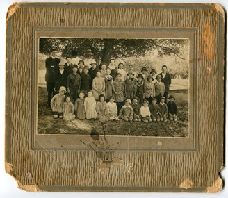
The Jarrahmond State School No. 2745 near Orbost was one of the earliest in this district. It opened in 1886 at the same time as Orbost and shared a teacher (Campbell McKay who was shortly afterwards replaced by John Rowe who stayed in this position until 1908). The building was financed and built by local farmers on the Stapley property. After a large and damaging flood in the nearby Snowy River in 1893 , the building was shifted to a new location. In 1926, a new building was constructed by the Vic Ed Dept. where it remained until the school was closed in 1948 and children from the Jarrahmond area were then bused to Orbost. Historical significance as one of the earliest photos of Jarrahmond School students.A b/w photo of a group of children and one adult in front of a tree. Children in the front are sitting on the ground, others are standing behind. Photo is mounted onto brown cardboard. On back of photo: Jarrahmond School c.1914. Sally Cole, Angus Cole.education, jarrahmond school, orbost -
 Eltham District Historical Society Inc
Photograph - Aerial Photograph, Landata, Eltham, Main Road; Henry St to Bellevue Rd, Dec. 1945
Eltham, Main Road; Henry St to Bellevue Rd, and east along Luck St to present day Eltham East School Historic Aerial Imagery Source: Landata.vic.gov.au Aerial Photo Details: Project No :5 Project : MELBOURNE AND METROPOLITAN AREA PROJECT Run : 36 Frame : 60549 Date : 12/1945 Film Type : B/W Camera : EAG4 Flying Height : 10200 Scale : 6000 Film Number : 228 GDA2020 : 37°42'45"S, 145°08'59"E MGA2020 : 336903, 5824465 (55) Melways : 21 K4 (ed. 42)aerial photo, arthur street, bellevue road, bible street, diamond street, dudley street, elsa court, eltham, eltham east primary school, gahan house, henry street, livingstone road, luck street, main road, pryor street, neil webster collection -
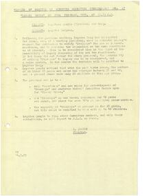
 Melbourne Legacy
Document - Document, report, Steering committee - Future of Residences
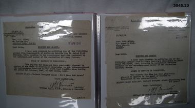
Report presented by the Steering Committee to the Board of Management dated 18 March 1975 with their recommendations for the future of Blamey House, Harelands and Stanhope. The Committee was chaired by Legatee A. Quayle and composed of Legatees J. Chancellor, H. Berg, H. Rodgers and E. Trebilcock. They noted that occupancy rates were falling (Appendix 'A') and it would not be economically viable to renovate the buildings. They recommended that: Harelands should be sold and Blamey House redeveloped for widows' accommodation, and that Stanhope should be modified for co-ed accommodation. The Committee requested that the matters raised in the report should be considered urgently. In a file with documents pertaining to the residences. Part of the history of Melbourne Legacy's involvement with residential care for children.Foolscap sheets x 3 pages, black on white copy. Two holes punched for filing. '18-3-75' pencilled on first sheet.residences, blamey house, harelands, stanhope -
 Eltham District Historical Society Inc
Photograph - Aerial Photograph, Landata, Research, Vic, Apr. 1963
Centred on present day Marconi Court, Research bounded by Maroondah Aqueduct to north, Thompson Crescent to south, Joselyn Drive to east and Eltham Research Oval to west. Historic Aerial Imagery Source: Landata.vic.gov.au Aerial Photo Details: Project No :486 Project : MELBOURNE (1963) PROJECT Run : 5 Frame : 62 Date : 04/1963 Film Type : B/W Camera : RC8 Flying Height : 5100 Scale : 9600 Film Number : 1805 GDA2020 : 37°42'24"S, 145°10'43"E MGA2020 : 339434, 5825157 (55) Melways : 22 F3 (ed. 42)aerial photo, neil webster collection, 1963-04, joselyn drive, marconi court, melway 22f3, research (vic.), research oval, thompson crescent -
 Eltham District Historical Society Inc
Photograph - Aerial Photograph, Landata, Research, Vic, Apr. 1972
Centred on present day Maroong Drive, Research bounded by Allendale Road to north, Thompson Crescent to south, Eltham College to east and Parsons Road to west. Historic Aerial Imagery Source: Landata.vic.gov.au Aerial Photo Details: Project No :985 Project : MELBOURNE 1972 Run : 26 Frame : 193 Date : 04/1972 Film Type : B/W Camera : RC10 Flying Height : 5700 Scale : 9600 Film Number : 2636 GDA2020 : 37°42'04"S, 145°10'33"E MGA2020 : 339187, 5825794 (55) Melways : 22 F1 (ed. 42)aerial photo, neil webster collection, 1972-04, allendale road, eltham, eltham barrel, eltham college, maroong drive, melway 22f1, parsons road, research (vic.), thompson crescent -
 Eltham District Historical Society Inc
Photograph - Aerial Photograph, Landata, Eltham, Vic, Apr. 1972
Centred on present day Ryans Road at Sandra Avenue, Eltham bounded by Progress Road to north, Brougham Street to south, Bible Street to east and Outlook Crescent to west. Historic Aerial Imagery Source: Landata.vic.gov.au Aerial Photo Details: Project No :985 Project : MELBOURNE 1972 Run : 27 Frame : 48 Date : 04/1972 Film Type : B/W Camera : RC10 Flying Height : 5700 Scale : 9600 Film Number : 2636 GDA2020 : 37°42'41"S, 145°08'38"E MGA2020 : 336392, 5824574 (55) Melways : 21 H4 (ed. 42)aerial photo, neil webster collection, 1972-04, eltham, bible street, brougham steet, melway 21h4, outlook crescent, progress road, ryans road, sandra avenue, montmorency -
 Eltham District Historical Society Inc
Photograph - Aerial Photograph, Landata, Montmorency, Vic, Apr. 1972
Centred on present day Olympic Avenue at Grand Boulevard, Montmorency bounded by Meruka Drive to north, Main Road to south, Main Road to east and Alban Street to west. Historic Aerial Imagery Source: Landata.vic.gov.au Aerial Photo Details: Project No :985 Project : MELBOURNE 1972 Run : 28 Frame : 206 Date : 04/1972 Film Type : B/W Camera : RC10 Flying Height : 5700 Scale : 9600 Film Number : 2635 GDA2020 : 37°43'21"S, 145°07'46"E MGA2020 : 335154, 5823329 (55) Melways : 21 E7 (ed. 42)aerial photo, neil webster collection, 1972-04, eltham, alban street, grand boulevard, lower plenty, main road, melway 21e7, meruka drive, montmorency, olympic avenue -
 Eltham District Historical Society Inc
Photograph - Aerial Photograph, Landata, Eltham, Vic, Apr. 1972
Centred on present day Mays Road at Stringybark Road, Eltham bounded by Nyora Road to north, Yarra River to south, Reynolds Road to east and Bible Street to west. Historic Aerial Imagery Source: Landata.vic.gov.au Aerial Photo Details: Project No :985 Project : MELBOURNE 1972 Run : 28 Frame : 209 Date : 04/1972 Film Type : B/W Camera : RC10 Flying Height : 5700 Scale : 9600 Film Number : 2635 GDA2020 : 37°43'33"S, 145°09'28"E MGA2020 : 337647, 5823013 (55) Melways : 22 B8 (ed. 42)aerial photo, neil webster collection, 1972-04, eltham, bible street, mays road, melway 22b8, nyora road, reynolds road, stringybark road, yarra river -
 Mission to Seafarers Victoria
Postcard - Photograph, Black and white, Green Bros, 1918
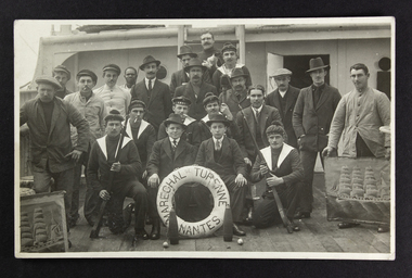
The Maréchal de Turenne, a three mast barque, was built in the "Chantiers de la Loire" shipyard in Nantes, port in the West of France, in 1899 by the company René Guillon et René Fleury. Capacity of 3000 barrels. The barque is called a "cap-hornier" in French. In a book written in 1973 by Georges Aubin, "La mer douce et cruelle", ed. France-Empire, a chapter "Une traversée du trois-mâts nantais Maréchal de Turenne" (page 285 to 319) tells how the ship was navigating from London to New-York to load barrels of petrol bound for Melbourne.The photograph demonstrates how prepared the merchant navy was during the First World War. The French Merchant Navy had additional men from the Navy: the six sailors in uniform and sailor "bachi" bonnet with the AMBC inscription were on the ship to support the crew in case of enemy attack. Two of those soldiers carry a bayonet. One of the sailors is wearing headphones: World War One saw telecommunication progress. At sea, the threat were the German submarines: the U-boats.The photograph depicting the 22 members of the crew was taken in October 1918 onboard the Marechal de Turenne. The two on the right and left side are holding a picture of the barque. One man at the back is holding a cat. 11 names are written at the back. The photograph was turned into a postcard.Printed at the back: On the left: Green Bros/Photo/251 Nelson Place, Williamstown Centered: Post Card/Correspondence/Address only Top right corner for the stamp: Kodak Australia Written at the back: octobre 1918 Souvenir du navire Maréchal de Turenne Berthot Jacquet Renaut R. Renaut H. Lecoq Mercier Berger Dubas Lorie Coat Tilloncrew, barque, french, 1918, marechal de turenne, nantes, wwi, world war one, first world war, great war, buoy, ship mascot, cat, a.m.b.c, bayonet, african, black man, apprentices, armement militaire des bâtiments de commerce, bachi, sailor beret, radio transmitters, telegraph, morse, telecommunication, german submarines, u-boats, cigarettes, smoking, williamstown, mission to seafarers, seamen's mission, nelson place, crews and ships -
 Tarnagulla History Archive
Transcripts: Cheetham Diary / Early Tarnagulla, 1857 (original diary) and 1928, 1997 (manuscripts)
Donald Clark Collection.Two typed documents, each of several pages. One is a transcript of part of the diary of James Cheetham during the time of his voyage from Liverpool, England to Tarnagulla, Australia. The other connected document is a typed account by amateur historian Donald Clark with the title 'Early History of Sandy Creek and Tarnagulla Goldfields'. It was 'transposed' by him in 1997 from a manuscript written in 1928 by the wife of James Cheetham, Dulcie. Her manuscript was compiled from the contents of original diaries she had which had been written by James Cheetham and Ed Peters when they lived in Sandy Creek/Tarnagulla during the towns early years. -
 Melbourne Legacy
Document - Document, minutes, Minutes of meeting of Steering Committee (Residences)
Minutes of the meeting held on 28th February 1975 which updated the information in Cat. No. 01693. Red Cross, which owned Stanhope and leased it to Melbourne Legacy, had been approached to consider Legacy's request to modify the residence. The numbers of children 16 years and under had averaged 35-40 with 26 currently in residence. The Committee now proposed that Harelands should be sold and Stanhope should become co-ed and modified to accommodate 40 children. Chairman Legatee Quayle undertook to ring other Committee members for their approval to pass these recommendations to the Junior Legacy Club. In a file with documents pertaining to the residences.Gives an insight into Legacy thinking about the way in which the residences should be used.Fading photocopy, originally black on white, now brown on cream. Two holes punched for filing. residences, review, blamey house, harelands, stanhope -
 Eltham District Historical Society Inc
Photograph - Aerial Photograph, Landata, Eltham / Research, Vic, Jan. 1951
Centred on Brinkkotter Road opposite Yarramie Reserve, Eltham bounded by Maroondah Aqueduct to north, Nyora Road to south, Eltham College to east and Leane Drive to west. Historic Aerial Imagery Source: Landata.vic.gov.au Aerial Photo Details: Project No :65 Project : MELBOURNE AND METROPOLITAN PROJECT NO. 2 Run : 7 Frame : 8 Date : 01/1951 Film Type : B/W Camera : EAG9 Flying Height : 12200 Scale : 12000 Film Number : 1419 GDA2020 : 37°42'32"S, 145°10'41"E MGA2020 : 339408, 5824924 (55) Melways : 22 F3 (ed. 42)Historical aerial photos and photo maps provide viusal evidence of the chronology of changes to the built landscape of the district and assist in dating other imagesaerial photo, 1951-01, eltham, neil webster collection, brinkkotter road, eltham college, leane drive, maroondah aqueduct, melways 22f3, nyora road, yarramie reserve -
 Eltham District Historical Society Inc
Photograph - Aerial Photograph, Landata, Eltham, Vic, Jan. 1951
Centred on Beard Street between Main Road and Frank Street, Eltham bounded by Maroondah Aqueduct to north, Arthur Street to south, Maroong Drive to east and Catholic Ladies College to west. Historic Aerial Imagery Source: Landata.vic.gov.au Aerial Photo Details: Project No :65 Project : MELBOURNE AND METROPOLITAN PROJECT NO. 2 Run : 7 Frame : 9 Date : 01/1951 Film Type : B/W Camera : EAG9 Flying Height : 12200 Scale : 12000 Film Number : 1419 GDA2020 : 37°42'23"S, 145°09'39"E MGA2020 : 337874, 5825170 (55) Melways : 22 B3 (ed. 42)Historical aerial photos and photo maps provide viusal evidence of the chronology of changes to the built landscape of the district and assist in dating other imagesaerial photo, 1951-01, eltham, neil webster collection, arthur street, beard street, catholic ladies college, frank street, main road, maroondah aqueduct, maroong drive, melway 22b3, research (vic.) -
 Eltham District Historical Society Inc
Photograph - Aerial Photograph, Landata, Eltham North, Feb. 1956
Centred on present day 54 Kelway Crescent, Eltham North bounded by Glen Gully Road to north, Meruka Drive to south, Eltham College to east and Leach Street to west. Historic Aerial Imagery Source: Landata.vic.gov.au Aerial Photo Details: Project No :250 Project : MELBOURNE OUTER SUBURBS PROJECT Run : 17 Frame : 113 Date : 02/1956 Film Type : B/W Camera : EAG9 Flying Height : 10000 Scale : 12000 Film Number : 1176 GDA2020 : 37°42'16"S, 145°08'08"E MGA2020 : 335650, 5825336 (55) Melways : 21 G2 (ed. 42)aerial photo, 1956-02, eltham, eltham north, glen gully road, leach street, main road, melway 21g2, meruka drive, montmorency, neil webster collection -
 Eltham District Historical Society Inc
Photograph - Aerial Photograph, Landata, Montmorency, Feb. 1956
Centred on present day Tahlee Place Reserve and Sherbourne Preschool, Montmorency bounded by Progress Road to north, Withers Way to south, Main Road to east and Leach Street to west. Historic Aerial Imagery Source: Landata.vic.gov.au Aerial Photo Details: Project No :250 Project : MELBOURNE OUTER SUBURBS PROJECT Run : 17 Frame : 114 Date : 02/1956 Film Type : B/W Camera : EAG9 Flying Height : 10000 Scale : 12000 Film Number : 1176 GDA2020 : 37°42'50"S, 145°08'02"E MGA2020 : 335512, 5824286 (55) Melways : 21 F5 (ed. 42)aerial photo, 1956-02, neil webster collection, central park, eltham, leach street, main road, melway 21f5, montmorency, progress road, withers way, sherbourne preschool, tahlee place reserve -
 Eltham District Historical Society Inc
Photograph - Aerial Photograph, Landata, Lower Plenty, Feb. 1956
Centred on present day 217 Old Eltham Road, Lower Plenty bounded by Pitt Street to north, Yarra River to south, Main Road to east and Bonds Road to west. Historic Aerial Imagery Source: Landata.vic.gov.au Aerial Photo Details: Project No :250 Project : MELBOURNE OUTER SUBURBS PROJECT Run : 17 Frame : 116 Date : 02/1956 Film Type : B/W Camera : EAG9 Flying Height : 10000 Scale : 12000 Film Number : 1176 GDA2020 : 37°43'58"S, 145°07'49"E MGA2020 : 335237, 5822186 (55) Melways : 21 E10 (ed. 42)aerial photo, 1956-02, neil webster collection, eltham, main road, bonds road, elham, lower plenty, melway 21e10, pitt street, yarra river -
 Eltham District Historical Society Inc
Photograph - Aerial Photograph, Landata, Eltham, Feb. 1956
Centred on present day Shalbury Avenue, Eltham bounded by Leane Drive and Parsons Road to north, Nyora Road to south, Reynolds Road to east and the Diamond Creek to west Historic Aerial Imagery Source: Landata.vic.gov.au Aerial Photo Details: Project No :250 Project : MELBOURNE OUTER SUBURBS PROJECT Run : 18 Frame : 95 Date : 02/1956 Film Type : B/W Camera : EAG9 Flying Height : 10000 Scale : 12000 Film Number : 1176 GDA2020 : 37°41'57"S, 145°09'51"E MGA2020 : 338145, 5825965 (55) Melways : 22 C1 (ed. 42)aerial photo, 1956-02, neil webster collection, eltham, diamond creek (creek), melway 22c1, nyora road, parsons road, reynolds road, shalbury avenue -
 Eltham District Historical Society Inc
Photograph - Aerial Photograph, Landata, Research, Vic, Feb. 1956
Centred on present day Thompson Crescent, Research bounded by Maroondah Aqueduct to north, Thompson Crescent and Nyora Road to south, Bells Hill Road to east and Eucalyptus Road to west Historic Aerial Imagery Source: Landata.vic.gov.au Aerial Photo Details: Project No :250 Project : MELBOURNE OUTER SUBURBS PROJECT Run : 19 Frame : 6 Date : 02/1956 Film Type : B/W Camera : EAG9 Flying Height : 10000 Scale : 12000 Film Number : 1176 GDA2020 : 37°42'38"S, 145°11'02"E MGA2020 : 339927, 5824736 (55) Melways : 22 H4 (ed. 42)aerial photo, 1956-02, neil webster collection, bells hill road, eltham, eucalyptus road, maroondah aqueduct, melway 22h4, nyora road, research (vic.), thompson crescent -
 Eltham District Historical Society Inc
Photograph - Aerial Photograph, Landata, Research, Vic, Apr. 1963
Centred on present day Thompson Crescent and Nicholson Close, Research bounded by Maroondah Aqueduct to north, Nyora Road to south, Eltham College to east and Eltham Gateway Hotel to west. Historic Aerial Imagery Source: Landata.vic.gov.au Aerial Photo Details: Project No :486 Project : MELBOURNE (1963) PROJECT Run : 5 Frame : 61 Date : 04/1963 Film Type : B/W Camera : RC8 Flying Height : 5100 Scale : 9600 Film Number : 1805 GDA2020 : 37°42'24"S, 145°10'06"E MGA2020 : 338528, 5825143 (55) Melways : 22 D3 (ed. 42)aerial photo, neil webster collection, eltham, 1963-04, eltham college, eltham gateway hotel and conference centre, maroondah aqueduct, melway 22d3, nicholson close, nyora road, research (vic.), thompson crescent -
 Eltham District Historical Society Inc
Photograph - Aerial Photograph, Landata, Eltham, Vic, Apr. 1963
Centred on present day John Street, Eltham between Main and Bible streets bounded by Elsa Court to north, Main Road Bridge to south, Wattle Grove to east and Bolton Street to west. Historic Aerial Imagery Source: Landata.vic.gov.au Aerial Photo Details: Project No :486 Project : MELBOURNE (1963) PROJECT Run : 6 Frame : 123 Date : 04/1963 Film Type : B/W Camera : RC8 Flying Height : 5100 Scale : 9600 Film Number : 1805 GDA2020 : 37°43'12"S, 145°08'54"E MGA2020 : 336800, 5823623 (55) Melways : 21 J6 (ed. 42)aerial photo, neil webster collection, 1963-04, bolton steet, elsa court, eltham, john street, main road, main road bridge, melway 21j6, wattle grove