Showing 2592 items
matching parts of buildings or structures
-
 University of Melbourne, Burnley Campus Archives
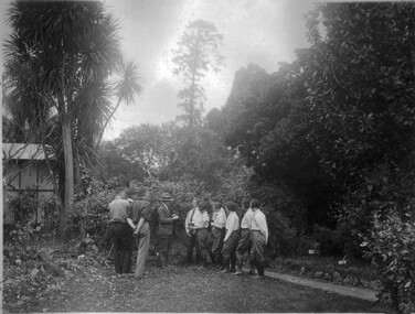
Photograph - Black and white print, A Demonstration at Burnley, c. 1925
Note by T.H. Kneen 11 December 1991, "Staff member (with hat) is Alex Jessep, Principal (1926-41). Photo probably mid 1920's. Note fibre cement structure at left-extension of Principal's Residence for Mr. McLennan's large family. Note also Cordyline outside main bedroom window of residence." This photograph was used for a postcard in Centenary Year, 1991.3 copies different sizes of black and white photograph. A group of students and Staff member near the Principal's Residence. Inscribed, "Title: A demonstration at Burnley Neg:177."students, principal's residence, demonstration, a.w jessep, principal, cordyline, postcard, centenary year, 1991, principal's house -
 Rutherglen Historical Society
Images, 1960s
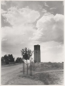
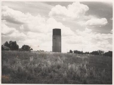
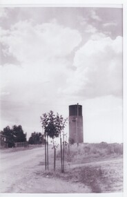
One of a collection of photographs from the Iggsten Estate. The water tower in the background is located in Hunter Street and was built in 1899-1900 to serve as the town's water supply. A new reservoir was built in 1945 with water being pumped from the Murray. A steel mesh structure, to make it look like a wine bottle, was added to the top in 1969 with funds from the Rutherglen Wine Festival.Black and white photograph, taken from the bottom on a hill, showing a water tower against the sky.water tower, wine bottle, tourism -
 Rutherglen Historical Society
Images, 1960s
One of a collection of photographs from the Iggsten Estate. The water tower in the background is located in Hunter Street and was built in 1899-1900 to serve as the town's water supply. A new reservoir was built in 1945 with water being pumped from the Murray. A steel mesh structure, to make it look like a wine bottle, was added to the top in 1969 with funds from the Rutherglen Wine Festival.Black and white photograph of a water tower, at the top of a hill, silhouetted against the sky.water tower, wine bottle, tourism -
 Rutherglen Historical Society
Images, 1960s
One of a collection of photographs from the Iggsten Estate. The water tower in the background is located in Hunter Street and was built in 1899-1900 to serve as the town's water supply. A new reservoir was built in 1945 with water being pumped from the Murray. A steel mesh structure, to make it look like a wine bottle, was added to the top in 1969 with funds from the Rutherglen Wine Festival.Black and white photograph, taken from the bottom on a hill, showing a water tower against the sky.water tower, wine bottle, tourism -
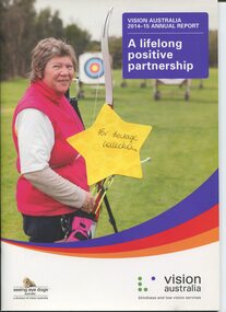 Vision Australia
Administrative record - Text, Vision Australia 2014-2015 Annual Report, 2015
Annual report providing overview of activities and achievements including: profiles of clients Cody Butler, James Griffiths, Debbie Lenehan and Marilyn Pursche, department of Jan Lovin-Kitchin from the Board, new regional structure formed, a Youth Egg Hunt time slot introduced at the Bendigo Easter Egg Hunt, support provided for tactile banknote and appointment of Sharon Bentley to the Board.1 volume with illustrations providing overview of organisational achievementsvision australia, corporation records, cody butler, james griffiths, debbie lenehan, marilyn pursche, hazel hockley, joshua campbell, ron hooton, kevin murfitt, jess gallagher, sam valavanis, sue-ann hanson, alimata karimu, connor mcleod, tijiske boonstra, taylor o'brien, sarah boulton, markus lenehan, ashley lenehan, kate begley, marcus bleechmore, kelly ryan, melissa rattle, zoe skjellerup, sasha skjellerup, kaylah fawcett, nicole damarra, robert barnes -
 Broadmeadows Historical Society & Museum
Document - School Project, A Jubilee Year Publication, 1977
This 1977 Jubilee Year publication was a special project undertaken by the Form 5 Politics Class at Salesian College, Rupertswood, as part of the school’s commemorative efforts to reflect on its past, present, and future. Created during a year of celebration and reflection, the project was both a civic and educational exercise, allowing students to explore the structure and culture of their school through the lens of political systems. Organised under the themes of Legislative, Executive, and Judicial branches, the publication presents a unique and structured interpretation of the college’s operations and community life. It includes contributions on key aspects of the school such as the Salesian order, the Parents and Friends Association, academic and sporting programs, the media, and the Old Boys’ Association. The project reflects the educational ethos of the time—encouraging inquiry, collaboration, and pride in one’s school. It also highlights the role of student voice in shaping the narrative of the college’s history. As a student-led initiative, this publication stands as a testament to the creativity, engagement, and reflective spirit of the 1977 cohort.This 1977 Jubilee Year publication, compiled by the Form 5 Politics Class at Salesian College, Rupertswood, is a significant historical document that captures the voice, perspective, and civic engagement of students during a milestone year in the college’s history. Created as a special project, the publication reflects a thoughtful and structured examination of the school’s identity through the lens of political systems—Legislative, Executive, and Judicial—demonstrating both creativity and critical thinking. The document is notable for its student-led authorship, its comprehensive scope—including reflections on the Salesians, the Parents and Friends Association, media, agriculture, academics, sport, and alumni—and its collaborative spirit. It offers a rare and valuable insight into how students of the time understood and interpreted the structure and culture of their school community. As a preserved artifact, this publication contributes meaningfully to the archival record of Salesian College. It not only documents the educational and social environment of the late 1970s but also highlights the enduring values of participation, reflection, and pride in community that continue to define the Rupertswood legacy.A 27 page stapled document, with a yellow front page (cover), detailing the history of Salesian College, Sunbury to 1977.salesian college, rupertswood, sunbury, 1977, jubilee -
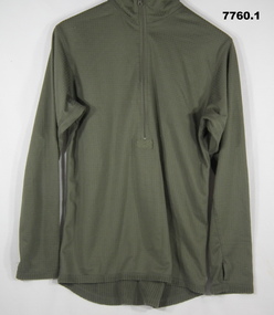 Bendigo Military Museum
Uniform - THERMALS, UNDERWEAR - ARMY, Unknown
Thermals, top and pants, jungle green colour, polyester/spandex fabric, grid structure and fleece lining. Nylon and metal zipper. 1. Top - polo shirt shape with collar, long sleeves with thumb hole and half zipper front closure. Black colour polyester manufacturers label, back below collar. 2. Pants - Long Johns - elastic waistband, front fly opening, long legs. Manufacturers label, back below waistband - black colour polyester fabric.Manufacturers information on label - white and gold print. 1. "GEN111/ SIZE M/ LONG SLEEVED TOP/ LEVEL 2/ HELIKON.TEX.COM/ ART.ID: BL-UH2-PO/ STOCK NO. 9415-09-229-1357/ NATO SIZE 7585/ 9404/ ACCORDING TO U.S. ARMY / SPECIFICATION." 2. "GEN111/ SIZE M/ LONG-JOHNS/ LEVEL 2/ HELIKON.TEX.COM/ COMFORT DRY/ HELIKON-TEX.COM/ 95% POLYESTER 5% SPANDEX/ AVOID USE OF FABRIC SOFTENERS/ ART.ID: SP.UN2.PO/ STOCK NO. 9415-09-229-1357/ NATO SIZE 7585/ 9404/ ACCORDING TO U.S. ARMY / SPECIFICATION." "PO#1325" uniform, army, underwear, thermals -
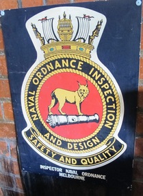 Mission to Seafarers Victoria
Sign, 20th Century
An example of elaborate enamel signage acquired as a result of the long standing close links of Naval forces with the Mission to Seafarers from 19th C onwards. A rectangular black enamel sign on metal ground featuring polychrome insignia of Naval Ordnance Inspection and Design. The insignia shows circular border of ropework encircling a red ground depicting a black and white cannon with a large lynx type feline. The ropework border is surmounted by a stylised crown like structure comprised of: a split focsle?, two sails with red pennants or burgees and stern of a galleon and around the band of the crown a red 'jewel' flanked by two blue green 'jewels'Insignia wording in yellow on black ground in upper case letters: " NAVAL ORDNANCE INSPECTION / AND DESIGN / SAFETY AND QUALITY " Below insignia in white paint in upper case letters: "INSPECTOR NAVAL ORDNANCE / MELBOURNE" ordnance, naval, design, safety, inspections, insignia, badge, sails, cannon, lynx -
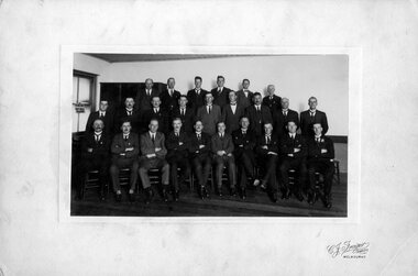 Victoria Police Museum
Photograph (Victoria Police), Police Officers group photo, 1920s
Black and white photograph mounted on grey frame. 16 Police Officers mounted on Horses. Black and white photograph mounted on bege frame. 25 men pose for photograph on 3row structure; they all wear polished suits. Men sitting at front row have their arms crossed, some in a serious countenance and other more witty. On the back there's piece of paper stuck which tells who are most of Police men in the picture - see Inscriptions. There's also velcrum piece on edges.Handwritten: (top left) 162 (top right) Ap 86 Paper glued with tape on the back, typewritten: First Council of the // Victorian Police Association. Left to right; Back row; Forget name of first one; John Searle; // Arthur Feldtman 7138; Francis McCorkell, Charles Heading; // White (Reporter) Middle Row. Gill (Police Association Secretary) ; Murdock McMillan; Uncertain next; George Fleming; Tom Morgan; Jim Ogden; Fred Hale; Uncertain name; George Burrows; Front row; Jim Dunn; Walter Elliott; John Grieve (Detective); Langslov // George Herbert Docking (Association President) General Blamey // William Adamson; McPherson; Arthur Wels; John // Cassiy. I Believe the 3rd person in centre row is Roderick McDonald but am not sure. // This picture was taken in the Temperance Hotel, Russel ST // Jim Ogden and myself were the only members of force who had joined after the police strike in 1923.victoria police museum, police officers, police academy, police force, c. j. frazer, mcdonald, roderick, langslov george herbeter docking, cassidy, john, welsh, arthur, mcpherson, general blamey, adamson, william, victorian police association, adamson, william, police council, grieve, john, elliott, walter, dunn, jim, burrows, george, hale, fred, ogden, jim, morgan, tom, fleming, george, mcmillan, murdock, secretary gill, reporter white, heading, charles, mccorckell, francis, feldtmann, arthur, searle, john, first council, temperance hotel -
 Bendigo Historical Society Inc.
Document - BENDIGO EASTER FAIR COLLECTION: EASTER FAIR PHOTOS
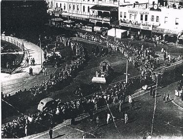
2 photocopies of Easter Fair photos. A. Floats rounding corner of Pall mall and View Streets, approx 1940's. B. Photo of float, flat tray carriage with box type structure on top, models of horses and men and stone type house, on top. 'KF' on side of float.(Kangaroo Flat) 4 men dressed in uniform, jacket and pants, logo on top of arm (indecipherable) and small hats. - could be fire brigade. Very early image, copy only and poor quality.bendigo, bendigo easter fair, parade -
 Bendigo Historical Society Inc.
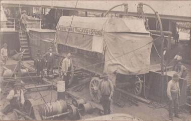
Photograph - BUTTON CARRIER BENDIGO, early 1900's ?
Sepia photo: Four wheeled cart with canvas top situated on deck of ship, alongside wharf which has large verandah type structure running length of it. Carts with large piles of bags visible behind wharf building. Workmen standing alongside cart, C. Button carriers Bendigo, printed on side of cart. Furniture Packed & Stored printed across topside of below canvas top. Winding machine with man holding lever on RH side of photo.organization, business, c. button carriers, bendigo -
 Bendigo Historical Society Inc.
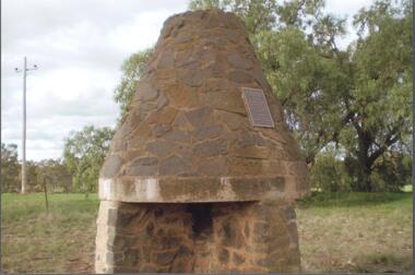
Photograph - BENDIGO HISTORICAL SOCIETY COLLECTION: BURKE AND WILLS CAIRN BARNADOWN
Colour photograph of bluestone fireplace erected at Barnadown to commemorate the camp site of the Burke and Wills expedition.The stone fireplace is a memorial to the Burke and Wills Expedition which camped near here. It was erected by the Waranga Shire Council to commemorate the centenary of the Victorian Exploring Expedition`s passage through the Barnadown district in 1860. A plaque on the structure reads: 'Burke and Wills Centenary. The party camped near this spot on 28th August 1860 on its outward journey. Erected by the Shire of Waranga 1960'.exploration, terrestrial, burke and wills -
 Bendigo Historical Society Inc.
Photograph - BENDIGO HISTORICAL SOCIETY COLLECTION: REDESDALE BRIDGE
Colour photograph of the Redesdale bridge over the Campaspe River at Redesdale. The Redesdale Bridge is one of the oldest iron lattice-truss bridges in Victoria, Australia. The Redesdale Bridge is a wrought iron and timber structure with bluestone abutments, located over the Campaspe River near the town of Redesdale. Image taken from Redesdale side of bridge showing two lane design. Plaque on bridge in centre of divided road reads ' Shire of Metcalfe'. Photo taken during a BHS tour, possibly 1990's.bridge -
 Bendigo Historical Society Inc.
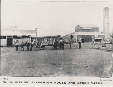
Photograph - HARRY BIGGS COLLECTION: W.B GITTENS SLAUGHTER HOUSE, C. 1900
Photograph showing a horse and long open sided cart with a covered roof, There are numerous carcasses (sheep?) hanging from the roof. There are seven men standing beside the cart. To the left of the cart there is a wooden building with a small brick chimney on the right hand end. To the right is a larger wooden structure with a large square brick chimney behind. There are also two other carts visible with their shafts resting on the ground. At the base of the photo is written Plate 147, W. B. Gittens Slaughter House and Stockyards.Robinsonbuildings, commercial, slaughter hopuse, w, b, gittens slaughter house and stock yards, robinson -
 Victorian Aboriginal Corporation for Languages
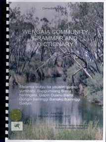
Book, Julie Reid, Wergaia community grammar and dictionary, 2007
This consultation draft is a sketch grammar of Wergaia, incorporating a revised Wergaia Wordlist (version 1), now renamed Wergaia dictionary, which was developed from recent and historical sources, and funded by the Victorian Aboriginal Corporation for Languages. It is not intended for use as a language course. To fully understand its contents, the reader will need a high level of knowledge about the structure of Australian languages. Rather, it is intended for use as an adjunct to a course in Wergaia, such as the VCE Study Design Indigenous Languages of Victoria: Revival and Reclamation - Wergaia.colour photographs, b&w photographs, word listswergaia, wotjobaluk, barengi gadyin land council inc, grammar, language learning -
 Rutherglen Historical Society
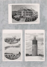
Post Card, various
Three black and white photographs of old postcards, mounted on a sheet of decorative grey paper. Top one is an early depiction of Fairfield House. Bottom left one shows two oval photographs with a banner between them. Top one of these is of a wheat harvest, bottom one is of Lake Moodemere Gala Day. Bottom right one shows the Rutherglen water tower, after it had been decommissioned and the structure added to the top to make it look like a wine bottle.fairfield house, water tower, rutherglen winebottle, lake moodemere, harvesting -
 Kew Historical Society Inc
Map, MMBW, MMBW Plan No.64 Kew & Heidelberg, 1900-1910
The Melbourne and Metropolitan Board of Works (MMBW) was established by an act of the Victorian Parliament in 1890 to prepare for and to implement a sewerage and water reticulation system across what was then inner Melbourne, its surrounding and middle distance suburbs, including Kew. The MMBW was disbanded in 1991.The map collection of the Kew Historical Society has at its core the historic maps assembled and originally stored in the City Engineer's Department of the City of Kew. These include maps in a number of scales. The vast majority of maps were produced by the MMBW in the first two decades of the twentieth century, and are solid working maps, backed by linen for durability. These maps are historically significant to Kew, the City of Boroondara and to the history of the development of state utilities in Victoria. A number of the Kew maps have additional details added by former municipal officers, including the levels reached by various floods. As these were working documents, information was added to them long after the period of their initial production and distribution.Early map of part of the Borough of Kew, created in the first decade of the twentieth century, at a scale 160 ft to 1 inch. The map covers what was then the northern most part of Kew, bordered on its north and west by the Yarra River, in the East by Connor's Creek and by the Asylum in the south. The map shows the extent of urban development by that time, prominent institutions and the outlines of built structures in the municipality. Contour lines and historic flood levels were added in ink to the map at a later stage.MELBOURNE AND METROPOLITAN BOARD OF WORKS / PLAN NO. 64 / KEW & HEIDELBERGmelbourne & metropolitan board of works, mmbw maps, mmbw plans, borough of kew, cartography -
 Kew Historical Society Inc
Map, MMBW, MMBW Plan No.65 Kew & Heidelberg, 1900-1910
The Melbourne and Metropolitan Board of Works (MMBW) was established by an act of the Victorian Parliament in 1890 to prepare for and to implement a sewerage and water reticulation system across what was then inner Melbourne, its surrounding and middle distance suburbs, including Kew. The MMBW was disbanded in 1991.The map collection of the Kew Historical Society has at its core the historic maps assembled and originally stored in the City Engineer's Department of the City of Kew. These include maps in a number of scales. The vast majority of maps were produced by the MMBW in the first two decades of the twentieth century, and are solid working maps, backed by linen for durability. These maps are historically significant to Kew, the City of Boroondara and to the history of the development of state utilities in Victoria. A number of the Kew maps have additional details added by former municipal officers, including the levels reached by various floods. As these were working documents, information was added to them long after the period of their initial production and distribution.Early map of part of the Borough of Kew, created in the first decade of the twentieth century, at a scale 160 ft to 1 inch. The map covers what was then the south central part of Kew, bordered on its north by Malmsbury Street, in the west by Florence Avenue, in the south by Barkers Road, and in the east by Princess Street. The map shows the extent of urban development by that time, prominent institutions and the outlines of built structures in the municipality. Contour lines were added in ink to the map at a later stage.MELBOURNE AND METROPOLITAN BOARD OF WORKS / PLAN NO. 65 / KEW & HEIDELBERGmelbourne & metropolitan board of works, mmbw maps, mmbw plans, borough of kew, cartography -
 Kew Historical Society Inc
Map, MMBW, MMBW Plan No.66 Kew, 1900-1910
The Melbourne and Metropolitan Board of Works (MMBW) was established by an act of the Victorian Parliament in 1890 to prepare for and to implement a sewerage and water reticulation system across what was then inner Melbourne, its surrounding and middle distance suburbs, including Kew. The MMBW was disbanded in 1991.The map collection of the Kew Historical Society has at its core the historic maps assembled and originally stored in the City Engineer's Department of the City of Kew. These include maps in a number of scales. The vast majority of maps were produced by the MMBW in the first two decades of the twentieth century, and are solid working maps, backed by linen for durability. These maps are historically significant to Kew, the City of Boroondara and to the history of the development of state utilities in Victoria. A number of the Kew maps have additional details added by former municipal officers, including the levels reached by various floods. As these were working documents, information was added to them long after the period of their initial production and distribution.Early map of part of the Borough of Kew, created in the first decade of the twentieth century, at a scale 160 ft to 1 inch. The map covers what was then the south eastern part of Kew, bordered on its north by Adeney Avenue, in the west by Sackville Street, in the south by Barkers Road, and in the east by Burke Road. The map shows the extent of urban development by that time, prominent institutions and the outlines of built structures in the municipality. Contour lines were added in ink to the map at a later stage.MELBOURNE AND METROPOLITAN BOARD OF WORKS / PLAN NO. 66 / KEW melbourne & metropolitan board of works, mmbw maps, mmbw plans, borough of kew, cartography -
 Beechworth Honey Archive
Extractor
Frames are uncapped with an uncapping knife, and placed into a holding spot or basket. The handle is then turned, spinning the frames inside. Eventually, the centrifugal force drains the honey from the frames. The honey can be poured from the drum via the tap. The empty frames go back into beehives to be filled with honey again.Antique two frame manual extractor. Metal 44 gallon drum with external tap, handle and hole. Inside; rotating two-frame honey extractor. The two frames are attached to a square metal structure. Each frame is only attached by one end. Each frame is a rectangular metal construction with square wire panels on two sides. Internal frame rotates freely. Other two sides and base solid. On top of drum is a hand-driven metal crank for turning internal frames.two, frame, hand, manual, extractor, honey, beechworth honey -
 Bacchus Marsh & District Historical Society
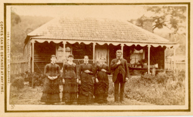
Photograph, Family group and farm house near Bacchus Marsh 1883
This image is one of several family group portraits taken by Stevenson and McNicoll on what appears to be a rural property. The identity of this family group and the location where the image was taken has not been identified. It is presumed to be in the Bacchus Marsh district and dates from around September-November 1883. The composition of the group appears to be a father and mother with three adult daughters.Small sepia unframed photograph on card with gold border framing photograph. Housed in the album, 'Photographs of Bacchus Marsh and District in 1883 by Stevenson and McNicoll'. The image shows a family group of four women and one man. They are standing in a single row in front of a farm house. The family in this image and the precise location of the property have not been identified. The house in the background is a single storey timber structure with a shingled roof and a verandah at the front. Two chimneys can be seen attached to the house.On the front: Stevenson & McNicoll. Photo. 108 Elizabeth St. Melbourne. COPIES CAN BE OBTAINED AT ANY TIME. On the back: LIGHT & TRUTH inscribed on a banner surmounted by a representation of the rising sun. Copies of this Portrait can be had at any time by sending the Name and Post Office Money Order or Stamps for the amount of order to STEVENSON & McNICOLL LATE BENSON & STEVENSON, Photographers. 108 Elizabeth Street, MELBOURNE. stevenson and mcnicoll 1883 photographs of bacchus marsh and district, farmhouses, families -
 Kiewa Valley Historical Society
Saucer Ceramic, circa 1940's to 1950's
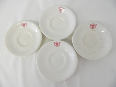
This item was used by the State Electricity Commission of Victoria in their mess rooms for their workers during the construction of the Kiewa Hydro Electricity Scheme. The imprint of the year "1921" was to identify the year that the SECV was formed and relieved the private VHEC (Victorian Hydro-Electric Company). As the scheme was of such a huge, isolated and time consuming nature the feeding of its workers was quite demanding of cutlery and crockery. The use of sturdy English cups and saucers was essential. The period of construction and the isolation of the Kiewa Valley area placed heavy demand for "solid" crockery that could wear abusive handling. This period in time was one when crockery, whether for domestic or commercial use, was imported from "mother" England. This scenario was more so for governmental bodies such as rail, jails and electricity providers than domestic users. The influx of cheaper Asian crockery had not yet begun.This type of crockery item was used by the thousands of SEC Victorian staff and construction workers involved in the building of the Kiewa Hydro Electricity Scheme, over the extensive period (1938 to 1961). This was a period when Government bodies and other semi- government organisations were still tied to the "establishments" of "mother" England. It was a period in Australia's development when the Asian influence was very weak and the established ties to England and Europe was still very strong. The majority of heavy equipment and machinery was either made in England or Europe. Local/European expertise in dam construction and water management in alpine terrain came from migrants or specially recruited English and Europe specialists. The quality of workmanship from big steel manufacturing plants in England and Europe could not be matched from anywhere else in the developed world.This item is a white ceramic State Electricity Commission Of Victoria saucer (tea /coffee). It is made in England and is of strong and durable ceramic. The bottom cup indent is for either tea or coffee cups of a similar ceramic structure. The 5mm thickness of the ceramic suggests this saucer belongs to a commercial kitchen environment and not domestic. The indent bottom of the saucer is 5mm deep with a side curvature ratio of 2:5. The ceramic is glazed to a commercial standard (worker's mess). See also KVHS 0128 (B to D)The seal of the State Electricity Commission Of Victoria is imprinted on the top inside rim within a curved scroll. Snuggled within the borders of the scroll is a banner with the five stars of the southern cross and an arm with a closed fist projecting from the top with five lightning bolts projecting outwards. On the underside "Vitrified sold by Cafe & Hotel Supplies Pty Ltd Dunn Bennett & Co. Ltd. Burslem Made in England"saucer, plate, secv, state electricity commission of victoria, crockery, mt beauty chalet, bogong mess hall -
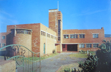 Mission to Seafarers Victoria
Postcard - Postcard, Colour, Alison Kelly, c. 1990
Also known as the King George V memorial building this branch of the Mission to Seamen opened in 1937 as a replacement for the old Mission in Port Melbourne. The Foundation stone was laid by the Victorian State Governor and a photograph of the event is also held in the MTSV collection. The Art Deco style building was commissioned by merchant and philanthropist, Alfred Michael Nicholas (1881-1937) and designed by prolific Melbourne-based architect Harry A. Norris (1888-1966) in 1937 best known for his commercial work in Melbourne city centre. NB PMHPS Kindly allowed MTSV heritage to take scans of the Kelly series notes in their collection for reference in 2019.One of the few full colour images of this building originally classified by the National Trust and now demolished. An example of architect Harry Norris' work 1937. All that remains are a ceramic plaque, a brick and several items of chapel artefacts. Alison Kelly, a photographer, was part of the group supporting the Port Melbourne Seamen's Mission in the 1980s and 1990s. She took a series of photographs of the building now held by the Port Melbourne Historical and Preservation Society.Full colour Postcard featuring colour image of a large red brick building in a 1930s era Architecture. There is a green wrought iron gate ajar in the foreground with the word SEAMAN spelled out. MISSIONS TO SEAMEN can also be seen spelled ut in white across and down the central clock tower of the building and this is surmounted with a white flagpole.On verso: Printed: "Heritage Series / POST CARD " at right angles in small print from lwr edge to upper: "PHOTOGRAPHY BY ALISON KELLY PORT HERITAGE SERIES NO 6". At Lwr left crnr printed:" Missions to Seamen Building, Port Melbourne/ Designed in the Modern style by architect Harry Norris,/ this 1937 National Trust classified structure was until 1972 / an entertainment and spiritual centre for seamen, with / important roles during the war [WW2] and immigration periods"king george v, memorial chapel, harry a. norris, brick, art deco, alfred m. nicholas, beach street, mission to seamen, alison kelly, 1937, arts centre, seamen mission, mission to seafarers, port melbourne -
 Orbost & District Historical Society
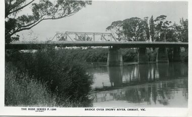
black and white photograph, Rose Stereograph Company, first half 20th century
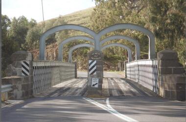
A new bridge over the Snowy River at Orbost was opened for traffic on June 20th 1922. It was a new timber and steel girder structure, a joint Country Roads Board — Victorian Railways venture and was built and completed at a cost of £41,000 (the steel girders came from the Flinders Street viaduct reconstruction). Subsequently it was decided not to take the railway across the river, and the bridge was only ever used by road traffic. Postcards form a vital part of social and historical records for researchers. This postcard is a pictorial record of an earlier bridge across the Snowy River at Orbost.A black / white postcard photograph of a bridge over the Snowy River at Orbost.0n front - The Rose Series P1200 copyright Bridge Over Snowy River Orbost Vic.snowy-river-bridge -
 Warrnambool and District Historical Society Inc.
Financial record - Ledger, Warrnambool Shire Council 1899-1918, Circa 1900
Provides a collection of letters to the President and Councillors of the Shire of Warrnambool from J. M. Crawley. The period covered is 1900 to 1918. It covers such topics as repairs to bridges, purchasing of equipment, complaints, applications for roads. Names of places and structures include Dennington Bridge, Cassidy’s Bridge, Warrumyea Bridge, Yangery, Purnim. Loose within the book is a letter from a W,M(H?) Clarke of Garvoc. The letters contained in this ledger provide information on a large range of works which were carried out in the Shire in the early 1900’sDark olive green fabric cover with tan spine and cornersMinute Book in gold lettering on red background on spine.warrnambool shire council 1899-1918, crawley j w crawley, warrnambool shire offices, warrnambool -
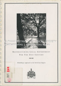 Eltham District Historical Society Inc
Document (Item) - Book, City of Heidelberg, Restructuring Local Government for the 21st Century: Heidelberg's approach to the North East Region, February 1994
The City of Heidelberg's Council first preference is "no change" [to municipal restructure] but if this option is unacceptable, the Council would prefer to form larger municipality/municapilites involving the exisitng City of Heidelberg and the Shires of Diamond Valley and Eltham. This report includes an exective summary, Introduction, A Brief History, Heidelberg and its [municiapl] neighbours now, opportunities for restructure, detailed analysis and preferred structure. Includes fold out maps.This report by the City of Heidleberg is a significant local contribution in the consultation leading to a significant change to local government in Victorian when, in 1994 the Kennett State government restructed local government. The reforms dissolved 201 Councils and created 78 new councils through amalgamations. In suburban Melbourne 53 municipalities were reduced to 26. The City of Heidelberg was amalgamated with parts of the Shire of Eltham and Diamond Valley to become the City of Banyule.annexation, council amalgamation, local government -
Ballarat Clarendon College
Plan
Front view of the new school building to be erected on the corner of Sturt and Lyons Streets within the grounds of St Andrew’s Kirk to replace the earlier wooden structure on the same site. The building was designed by the noted Ballarat architect, Henry Caselli, and this drawing is taken from his original plans which were made available to the College in 1992 by L H Vernon and Associates Pty. Ltd. -
 Halls Gap & Grampians Historical Society
Photograph - B/W, 14/04/1931
The photo shows the opening ceremony of Henham Township by Lord Stradbroke (the man on the right of the structure). A strip of land 2 kilometres long and half a kilometre wide had been approved as suitable for subdivision into 591 quarter acre blocks valued at 30-35 pounds each. Unfortunately it turned out to be a "fizzer". For further information see Victoria's Wonderland pp 93-95, 103.`Photo shows five men, middle foreground all standing, with others seated and standing in the background. The man stranding closest to the camera is holding a piece of paper in his hand. A rock pile and low stone fence can be seen middle foreground. A pulley is attached to a tripod of tree posts and is holding up a large cut stone. Mountains are visible in the background.events, ceremonies -
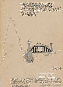 Eltham District Historical Society Inc
Book, Graem Butler, Heidelberg Conservation Study, Part 1 Heidelberg Historic Buildings and Areas Assessment by Graeme Butler, November 1985
Historic Buildings and Areas Assessment by Graeme Butler. Part 1 of award winning study carried out in 1982 in collaboration with a community advisory committee to Heidelberg City Council. Pioneering identification of a broad range of heritage assets varying from buildings, gravestones, farm structures, landscape areas, mileposts, divided street construction, in a time when buildings only were assessed in municipal studies.2 v. : ill., maps ; 29 cm.significant buildings heidelberg victoria, history development of heidelberg victoria, man-made landscape heidelberg victoria, significant precincts heidelberg victoria, conservation study, graeme butler -
Hume City Civic Collection
Photograph, St. Mary's Church, Bulla, 1970S
The church in the image is St. Mary's Church of England in Bulla after it was moved from its original location at the corner of Oaklands and Sunbury Roads to the Bulla township adjacent to the former Bulla Shire Officers. The move was necessary because the building was close to the international airport and its location interfered with the airport's signaling system and cracks were appearing in its structure from vibrations caused by lowlying aircraft.A coloured non-digital photograph of a small bluestone church set in an open area with a line of gum trees in the background.churches, st. mary's anglican church - bulla, bulla, tullamarine airport