Showing 1526 items
matching aerial photograph
-
 Lakes Entrance Historical Society
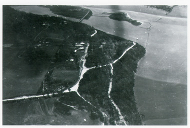
Photograph - Kalimna, Bulmer H D, 1940c
... Black and white photograph of aerial view of Kalimna... photograph of aerial view of Kalimna escarpment, Princes Highway ...Black and white photograph of aerial view of Kalimna escarpment, Princes Highway, road to Kalimna Hotel, scattering of buildings including Gainsborough House, in distance is North Arm bridge, footbridge to undeveloped Bullock Island with rock groynes in place. Part of eastern pier of entrance at Lakes Entrance, Victoria. waterways, topography, township, bridges -
 Bendigo Historical Society Inc.
Photograph - BENDIGO SHOWGROUNDS
... Aerial black and white photograph of the Bendigo... BENDIGO Streetscape showgrounds Aerial black and white photograph ...Aerial black and white photograph of the Bendigo showgrounds. Date unknown. There is a sticker 'you are now here at the stand of Frank A. Hill & co. Several of the pavilion are named: horses (x4), cattle, pigs, Lansell Hall, sheep, wool, dogs, poultry booth, sideshows, centre hall, park road hall and luncheon.bendigo, streetscape, showgrounds -
 Lakes Entrance Historical Society
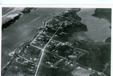
Photograph - Lakes Entrance, Bulmer H D, 1940c
... Black and white photograph of aerial view of township...Waterways Township Black and white photograph of aerial ...Black and white photograph of aerial view of township. It shows route of Princes Highway through town, turning north at Myer Street and continuing along Roadknight Street. Few jetties on North Arm, many on Cunninghame Arm. In far upper left of image sea is breaking on sand hummocks. Lakes Entrance Victoriawaterways, township -
 Bendigo Military Museum
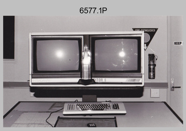
Photograph - AITA Award - RA Svy’s AUTOMAP 2 Computer Based Map Production System, Army Survey Regiment, Fortuna, Bendigo, 1984
... aerial photographs. It incorporates a voice recognition system so... aerial photographs. It incorporates a voice recognition system so ...This collection of three photos of the Australian information Technology Award (AITA) won by the Royal Australian Survey Corps (RA Svy) AUTOMAP 2 computer-based map production system, was taken in 1984 at the Army Survey Regiment, Fortuna, Bendigo. The following article appeared in the ARMY Newspaper on Thursday 21st February 1985. ‘In computerised map production. Survey soldiers lead the world. BENDIGO: Army surveyors have been put on the map as world leaders in computerised map production following the Australian information Technology Awards. RA Svy won the Computer Assisted Draughting – Mapping section for its Automap II System which has created considerable interest among overseas defence experts. The award for the digital mapping system was accepted by OC Air Survey Sqn, MAJ Rob John, who said it was a great morale-booster for the soldiers of the Bonegilla (sic)* -based Army Survey Regiment. "Setting up a state-of-the-art system like Automap II. is an enormous task, " he said. "We started in August 1983 and it's only recently that we have achieved production results. "We were all very pleased to have our efforts recognised in this way. “Of course, credit must also go to the Intergraph Corporation for manufacturing the system and carrying out most of the development." RA Svy is responsible for producing all of Australia's maps used for defence purposes. Its topographical maps have a scale of 1:50,000 or 1:100,000 although Automap II has the capability of producing smaller scale maps - down to 1: 2,000,000. Automap II consists of three computers and three sub-systems: input, raster scanning, and graphic edit. The input sub-system has eight stereo plotters, two interactive graphic workstations and a system manager workstation. The stereo plotters use superimposition optics to digitise features from aerial photographs. It incorporates a voice recognition system so the operator can simply say "House", "Windmill", etc; and the relevant feature will be incorporated in the digital picture. Individual map separations are scanned and converted by the raster scanning sub-system to a digital raster image. This image is then converted to a graphics file in Intergraph format.’ *Note – the Army Survey Regiment was located in Bendigo, not Bonegilla as incorrectly stated in the article. The article appears on Page 137 of Valerie Lovejoy’s book 'Mapmakers of Fortuna – A history of the Army Survey Regiment’ ISBN: 0-646-42120-4. Additional history of the AUTOMAP 2 system with historic photographs is covered in pages 119, 137-143 and 157 of the 'Mapmakers of Fortuna’ book. See item 6223.23P for additional history and photographs of the AUTOMAP 2 system.This collection of three photos of the Australian information Technology Award (AITA) won by the Royal Australian Survey Corps (RA Svy)’s AUTOMAP 2 computer-based map production system, was taken in 1984 at the Army Survey Regiment, Fortuna, Bendigo. The photographs are printed on photographic paper and are part of the Army Survey Regiment’s Collection. The black and white photographs were scanned at 300 dpi. .1) - Photo, black & white, 1984, AITA Award sitting between the dual screens of an AUTOMAP 2 Graphic Edit Workstation. .2) - Photo, black & white, 1984, MAJ Job Johns (centre) and two of Intergraph Corporation IT engineers proudly hold the AITA Award next to an AUTOMAP 2 Graphic Edit Workstation. .3) - Photo, black & white, 1984, The AITA Award displayed on a pedestal in the Army Survey Regiment Officers Mess. .1P to .3P –No personnel are identified. ‘AITI Award to AUTOMAP II 1984’ annotated on cover sleeve. royal australian survey corps, rasvy, army survey regiment, army svy regt, fortuna -
City of Kingston
Photograph - Colour, Circa 1993
... Aerial colour photograph of Edithvale as viewed from... type on white adhesive sticker: P000108 Aerial colour ...Edithvale is a suburb in the City of Kingston. It is located between Aspendale and Chelsea on the Port Phillip Bay and built within remnant areas of the Carrum Carrum swamp. The foreshore precinct comprises a wide sandy beach, with low sand dunes and numerous historic boat sheds. The suburb consists of older style dwellings and former holiday houses, combined with mid-century housing and newer homes. The large blocks are increasingly subdivided and the existing dwellings demolished to accommodate units and townhouses, thus changing the landscape of the area and reducing the tree canopy.The beachside suburb of Edithvale was previously part of the extensive Carrum Carrum Swamp. The area was once a source of fish and eels for the Mayone-Bulluk clan of the Bunurong people. Over time the area was drained and predominantly devoted to dairy farming and holiday houses. The farms were gradually sold and subdivided with a large number of homes built after World War II and in the 1960s. Edithvale is mainly residential with a shopping strip along Nepean Highway but little significant industry was ever established in the area apart from a plaster works and confectionary factory, both now closed.Aerial colour photograph of Edithvale as viewed from Alexandra Avenue in the north to Ella Grove Chelsea/Edithvale in the south. The area is built-up with residential housing and facilities including Edithvale Primary School, numerous churches and the Edithvale Railway station. Large sections depict the remnant Carrum Carrum swamp. Edithvale Common and the former "Duck Inn" (Melbourne Water/Friends of Edithvale Seaford Wetlands) can be seen. Edithvale Recreational reserve, the velodrome and Edithvale Public Golf Course are prominent. The image shows vacant land in the area now known as Aspendale Gardens and the newer residential section of Chelsea Heights is not developed. A bike path has been established to cover the secondary drain. The Golf Links Court residential development located off Hughes Avenue is a large vacant block.Yellow circular adhesive sticker on plastic Black ink (marker): * (asterisk) Black type on white adhesive sticker: P000108edithvale, aspendale, chelsea, carrum carrum swamp -
Bendigo Historical Society Inc.
Photograph - FORTUNA COLLECTION: AERIAL VIEW OF BENDIGO 1963
... Black and white photograph, aerial view of Bendigo 1963... Black and white photograph, aerial view of Bendigo 1963, Fortuna ...Black and white photograph, aerial view of Bendigo 1963, Fortuna Villa in foreground. On bottom of photograph ' Fortuna, an aerial view of Bendigo Circa 1963' Fortuna Villa in foregound of image, showing very clear detail of grounds. Image has labels of following sites: Lansell's 222 mine Lazarus mine site Central Red, White and Bluye mine site, Old Chum mine site New Chum and Victoria mine site West End Hall Mount Alvernia BCV8 QEO -
City of Kingston
Photograph - Colour, 6 March 1993
... Laminated aerial colour photograph of Edithvale as viewed... pointing N Laminated aerial colour photograph of Edithvale ...Edithvale is a suburb in the City of Kingston. It is located between Aspendale and Chelsea on the Port Phillip Bay and built within remnant areas of the Carrum Carrum swamp. The foreshore precinct comprises a wide sandy beach, with low sand dunes and numerous historic boat sheds. The suburb consists of older style dwellings and former holiday houses, combined with mid-century housing and newer homes. The large blocks are increasingly subdivided and the existing dwellings demolished to accommodate units and townhouses, thus changing the landscape of the area and reducing the tree canopy.The beachside suburb of Edithvale was previously part of the extensive Carrum Carrum Swamp. The area was once a source of fish and eels for the Mayone-Bulluk clan of the Bunurong people. Over time the area was drained and predominantly devoted to dairy farming and holiday houses. The farms were gradually sold and subdivided with a large number of homes built after World War II and in the 1960s. Edithvale is mainly residential with a shopping strip along Nepean Highway but little significant industry was ever established in the area apart from a plaster works and confectionary factory, both now closed.Laminated aerial colour photograph of Edithvale as viewed from Alexandra Avenue in the north to Ella Grove Chelsea/Edithvale in the south. regents Park Aspendale can be seen in the top left. The area is built-up with residential housing and facilities including Edithvale Primary School, numerous churches and the Edithvale Railway station. Large sections depict the remnant Carrum Carrum swamp. Edithvale Common and the former "Duck Inn" (Melbourne Water/Friends of Edithvale Seaford Wetlands) can be seen. Edithvale Recreational reserve, the valodrome and Edithvale Public Golf Course are prominent. The image shows vacant land in the area now known as Aspendale Gardens and the newer residential section of Chelsea Heights is not developed. A bike path has been established to cover the secondary drain. The Golf Links Court residential development located off Hughes Avenue is a large vacant block.Black type on white adhesive label: 6-3-93 Black type on white adhesive label: 25/9211, 6/3/93, 11.20 am Black type on white adhesive label: 9211 Yellow circular adhesive sticker Black pencil: 9211 6-3-93 arrow pointing Nedthvale, carrum carrum swamp, aspendale, chelsea -
 Lakes Entrance Historical Society
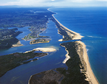
Photograph - Lakes Entrance, 1985c
... Colour photograph showing aerial view of township... Topography Township Colour photograph showing aerial view of township ...Photo was cut from Tourist brochureColour photograph showing aerial view of township and the Ninety Mile Beach. Pecks factory on Bullock Island, Old North Arm bridge, bitumen for carpark for future. Fishermen's Club near North Arm Bridge. Photo shows East end of Rigby Island and Snake Island. Glimpse of Red Bluff, Lake Bunga and Lake Tyers in far east. Lakes Entrance Victoriabridges, coast, waterways, topography, township -
 Warrnambool and District Historical Society Inc.
Book, City of Warrnambool
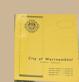
... page has an aerial black and white photograph of the city... proclamation dates. The inside facing page has an aerial black ...This booklet printed for the Warrnambool Promotion and Development Board in the 1960's showcases the city. It includes brief summaries and black and white photographs of major industries and benefits of the city. Warrnambool was proclaimed a municipality on 7th December 1855, a borough on 1st December 1863, a town on 2 February 1883 and a city on 8th April 1918.This booklet gives a brief overview of the development of the city in the 1960's. This is a 16 page stapled booklet printed in blank ink on glossy paper with black and white photos. The cover is yellow card with a Warrnambool City logo printed in black ink on the top left and the words City of Warrnambool Victoria Australia in the lower third and milestone proclamation dates. The inside facing page has an aerial black and white photograph of the city with a mauve banner at the lower edge.In a mauve rectangle on half of the upper edge is printed in black ink "Warrnambool where Australian Hospitality is a reality" The front cover and inside facing page have oval green ink stamp "Warrnambool North Technical School Library"city of warrnambool, warrnambool promotion and development board -
 Bendigo Military Museum
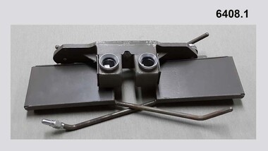
Instrument - Universal Stereoscope, 1940
... stereo aerial photography in three dimensions (3D). It consists... stereo aerial photography in three dimensions (3D). It consists ...The Universal Stereoscope was used to view overlapping stereo aerial photography in three dimensions (3D). It consists of magnifying lenses, an optical train including glass prisms and mirrors that are protected by sliding metal covers all suspended on a pair of fold out adjustable legs. The stereoscope is coloured military olive drab green. This Universal Stereoscope was produced in Australia in 1940 for Military use. It was originally produced with a timber protecting carry box that is missing. It was used extensively by members of the Australian Survey Corps during WWII in many theatres of War for viewing and annotating aerial photography. Item 6205.6P, photograph 6205.1P shows the Universal Stereoscope in use by the Australian Survey Corps annotating aerial photography.The Universal Stereoscope was used to view overlapping stereo aerial photography in three dimensions (3D). It consists of magnifying lenses, an optical train including glass prisms and mirrors that are protected by sliding metal covers all suspended on a pair of fold out adjustable legs. The stereoscope is coloured military olive drab green."DC-1940 Serial No 550", "D V D", "Made in Australia" Plate on the underside reads " This stereoscope was donated to the Ex Fortuna Survey Association by the Eaglehawk Recycle Shop February 2015"royal australian survey corps, rasvy, fortuna, army survey regiment, army svy regt, asr -
 Bendigo Military Museum
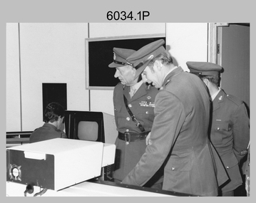
Photograph - Visit by the Chief of the General Staff to the Army Survey Regiment, Fortuna, Bendigo, 1979
... , KBE CB viewing an aerial photograph. WO1 Brian Mead..., KBE CB viewing an aerial photograph. WO1 Brian Mead and others ...This is a set of 14 photographs of a visit to the Army Survey Regiment, Fortuna, Bendigo on the 5th of June 1979 by the Chief of the General Staff (CGS) Lieutenant General Sir Donald Dunstan AC, KBE, CB. He was accompanied by his wife. They were escorted through the production areas of the Army Survey Regiment by the CO LTCOL Bob Skitch. Lieutenant General Sir Donald Dunstan AC, KBE, CB was an esteemed Australian Army officer, who was CGS from 1977 to 1982. Upon retirement from the Army in 1982, he was appointed to the position of Governor of South Australia from 1982 to 1991. LTCOL Bob Skitch was the CO of the Army Svy Rgt from 1976 to 1980. Also featuring in these photos is MAJ Peter Eddy, who was the OC of Air Survey Squadron. He was later promoted to LTCOL and was CO of the Army Svy Rgt from 1981 to 1982. See item 6035.9P for photos of the CGS’s presentation of the Defence Force Service Medal to four recipients.This is a set of 14 photographs of a visit by the Chief of the General Staff to the Army Survey Regiment Fortuna, Bendigo on the 5th of June 1979. The photographs were printed on photographic paper and are part of the Army Survey Regiment’s Collection. They were scanned at 300 dpi. .1) - Photo, black and white, 1979. Tour of Air Survey Squadron. L to R: unidentified, LTGEN General Sir Donald Dunstan AC, KBE, CB; OC MAJ Peter Eddy, unidentified. .2) - Photo, black and white, 1979. Tour of Air Survey Squadron. LTGEN General Sir Donald Dunstan AC, KBE, CB; views 3D stereoscopic aerial photography on a Zeiss (Jena) Stecometer. OC MAJ Peter Eddy is on his right. .3) - Photo, black and white, 1979. Tour of Air Survey Squadron. L to R: unidentified, CO LTCOL Bob Skitch, OC MAJ Peter Eddy, LTGEN General Sir Donald Dunstan AC, KBE CB viewing an aerial photograph. WO1 Brian Mead and others are operating a Wild PUG4 point transfer device. .4) - Photo, black and white, 1979. Enlargement of photo .3). Tour of Air Survey Squadron. L to R: unidentified, CO LTCOL Bob Skitch, OC MAJ Peter Eddy, LTGEN General Sir Donald Dunstan AC, KBE CB viewing an aerial photograph. .5) - Photo, black and white, 1979. Tour of Air Survey Squadron. LTGEN General Sir Donald Dunstan AC, KBE, CB; and unidentified technician view 3D stereoscopic aerial photography on a Wild B8 stereo plotter. .6) - Photo, black and white, 1979. Tour of Air Survey Squadron. L to R: OC MAJ Peter Eddy LTGEN General Sir Donald Dunstan AC, KBE CB; CO LTCOL Bob Skitch, view the output of a verification plot on an AUTOMAP 1 Gerber 1442 drum plotter. .7) - Photo, black and white, 1979. Tour of Air Survey Squadron. L to R: CO LTCOL Bob Skitch, unidentified aide de camp officer, LTGEN General Sir Donald Dunstan AC, KBE CB; OC MAJ Peter Eddy discuss aero triangulation planning documents. CAPT Don Maskew in background. .8) - Photo, black and white, 1979. Tour of Cartographic Squadron. L to R: CPL Dennis Learmonth, acting OC CAPT Bob Roche, CAPT Eddy Schulze, LTGEN General Sir Donald Dunstan AC, KBE CB; SSGT John ‘JB’ Barrie discuss cartographic map compilation procedures .9) - Photo, black and white, 1979. Tour of Cartographic Squadron. L to R: Tech WO WO1 Roger Rix, acting OC CAPT Bob Roche, CAPT Eddy Schulze, unidentified visitor, Mrs Dunstan with examples of map products. .10) - Photo, black and white, 1979. Tour of Cartographic Squadron. L to R: CPL Terry Danger, CO LTCOL Bob Skitch, LTGEN General Sir Donald Dunstan AC, KBE CB; discuss terrain embossing (hill shading) procedures. .11) - Photo, black and white, 1979. Tour of Cartographic Squadron. L to R: CO LTCOL Bob Skitch, LTGEN General Sir Donald Dunstan AC, KBE CB; acting OC CAPT Bob Roche, SSGT Dick Manley, CAPT Don Maskew and CAPT Steve Cooper in background. SPR Cheryl Lofthouse is retouching blemishes on a map separation film negative. .12) - Photo, black and white, 1979. Tour of Lithographic Squadron. L to R: CAPT Stan Vote, unidentified aide de camp officer, CO LTCOL Bob Skitch, LTGEN General Sir Donald Dunstan AC, KBE CB; MAJ Sam Schwartz EXCH-US, LT John Harrison discuss bulk map printing processes with an Ultra-MAN-III Printing Press. .13) - Photo, black and white, 1979. Officers Mess L to R: LTGEN General Sir Donald Dunstan AC, KBE CB; with CO LTCOL Bob Skitch. .14) - Photo, black and white, 1979. Officers Mess L to R: MAJ Peter Eddy, LTGEN General Sir Donald Dunstan AC, KBE CB..1P to .14P – no annotationsroyal australian survey corps, rasvy, army survey regiment, army svy regt, fortuna, asr -
 Bendigo Military Museum
Photograph - Johnson Ground Elevation Meter (JGEM) Survey Vehicle - Army Survey Regiment, Fortuna, Bendigo, c1960s
... identified on aerial photographs. Under favourable conditions... identified on aerial photographs. Under favourable conditions ...This is a set of 16 photograph of the Royal Australian Survey Corps’ Johnson Ground Elevation Meter (JGEM) Survey Vehicle taken at the Army Survey Regiment, Fortuna, Bendigo. The JGEM vehicle was extensively used by RA Svy within Australia from the late 1960s. A limited number of Ground Elevation Meter (GEM) station wagon type vehicles were manufactured by General Motors Corporation (GMC) in the USA for the United States Geological Survey, Canada’s mapping agencies, RA Svy and National Mapping (Natmap). The GEM was a four-wheel drive, four-wheel steer vehicle. Four-wheel steering was necessary to avoid systematic errors caused by non-tracking of front and rear wheels on conventionally steered vehicles. The manufacturer substituted the rear axle with a front axle and connected them to form the four-wheel steering mechanism. The two Australian GEM vehicles, referred to as Johnson GEMs (JGEMs) were converted into right-hand drive. After delivery in 1964, acceptance Natmap and RA Svy testing and operator training was undertaken at the Army's School of Military Survey located at Balcombe, Victoria. A small fifth wheel was mounted on a cantilever arm suspension midway between the front and rear wheels on the right side of the vehicle. It was lowered to and raised from its operating position by use of a constant pressure air cylinder. A telescopic bar, suspended between the front and rear axles, provided the reference datum for the angle measurement. The wheel provided the velocity or distance signal through a pulse generator system. A sensitive pendulum mounted on this bar provided the angle measurement for each minute distance traversed. The JGEM contained electromechanical instruments used to determine relative elevations, by trigonometric principles, along a traversed path. These relative elevations were obtained through apparatus which measures the instantaneous angle of inclination of the road and the instantaneous velocity of the meter along such a path. Road routes over which the JGEM operated were planned so that each started and ended as near as practicable to an existing point of known elevation (formally referred to as a level traverse bench mark). The difference in height from the bench mark and the road surface alongside the JGEM’s fifth wheel was measured with a level and staff. Along each route, mapping control photo reference points where new elevation values were required were identified on aerial photographs. Under favourable conditions it was possible to survey as much as 160km in an ordinary working day. The first of RA Svy’s JGEM operations was undertaken in 1:250,000 scale map areas of Queensland. CPL John Hook was the JGEM’s main operator in the early 1970s undertaking operations covering 1:250,000 scale map blocks over northern Victoria and central NSW, each requiring 36 points (9 runs of photography and 4 points across. SPR Lyn Thompson and SPR Bob McDonagh teamed with CPL Hook on some of these JGEM operations. When RA Svy was integrated into the Royal Australian Engineers in 1996, the JGEM vehicle with the Survey Corps collection was donated to its museum. It is believed to be the last of the original manufactured fleet in existence. The JGEM has undergone extensive refurbishment to achieve roadworthiness and is currently housed at The Australian Army Museum of Military Engineering, Hoslworthy Barracks, NSW. It can be viewed by making an appointment with the museum’s curator.This is a set of 16 photograph of the Royal Australian Survey Corps’ Johnson Ground Elevation Meter (JGEM) Survey Vehicle taken at the Army Survey Regiment, Fortuna, Bendigo. The photographs were on 35mm slide film and were scanned at 96 dpi. They are part of the Army Survey Regiment’s Collection. .1) - Photo, colour, c1960s, Johnson Ground Elevation Meter (JGEM) Survey Vehicle .2) - Photo, colour, c1960s, JGEM instrumentation, on-board computer. .3) - Photo, colour, c1960s, JGEM instrumentation. .4) - Photo, colour, c1960s, JGEM instrumentation, on-board computer. .5) - Photo, colour, c1960s, JGEM tyre pressure controller .6) - Photo, colour, c1960s, JGEM rear doors, SGT Geoff Briggs. .7) - Photo, colour, c1960s, JGEM 5th wheel distance/angle measurement device in lowered position, SGT Geoff Briggs. .8) - Photo, colour, c1960s, JGEM 5th wheel distance/angle measurement device in lowered position. .9) & .10) - Photo, colour, c1960s, JGEM tyre pressure system, SGT Geoff Briggs. .11) - Photo, colour, c1960s, JGEM tyre pressure system. SGT Geoff Briggs. .12) - Photo, colour, c1960s, JGEM levelling scope, levelling staff, unidentified technicians. .13) & .14) - Photo, colour, c1960s, JGEM levelling scope, unidentified technician. .15) & .16) - Photo, colour, c1960s, probably survey operation adjusted height plotted on block base sheet. .1P to .16P - Some of the equipment is annotated on the frame of the 35mm slides.royal australian survey corps, rasvy, army survey regiment, army svy regt, fortuna, asr, surveying -
 Eltham District Historical Society Inc
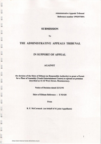
Document - Folder, Ron F. McCormack, Appeal against Eltham Shire Permit granted for a propsed Youth Enterntainment Centre, 41-43 Were Street, Montmorency, 1993-1994
... colour aerial photographs of Montmorency Shopping Village (some... colour aerial photographs of Montmorency Shopping Village (some ...In 1993 Eltham Shire Council issued a permit to Michael Muzur, Terry Lant and Andrew McMillan to redevelop the former Montmorency Theatre/Bingo Hall at 41-43 Were Street as an alcohol-free youth entertainment centre. Ron McCormack, retired former JP on behalf of 41 Joint Appellants consisting of local residents and traders successfully lobbied the community and won an Appeal to have the permit cancelled as unsuitable development. The Administrative Appeal Tribunal found that the proposed development came withing the Eltham Planning Scheme definition of an 'amusement parlour' and that the playing of pool an amusement machines would be the focus of the centre and unlikely to attract older age groups. The tribunal was not satisfied the applicants had sufficient knowledge or where with all required for the successful running of this type of operation. With respect to the objectors, the Tribunal did not accept that a responsibly managed and attractive amusement parlour could not coexist near the adjoining residential area and without detriment to the commercial centre. At a Council meeting on June 7, 1994 councillors requested a report outlining criteria to be used to assess planning applications for youth entertainment venues given the Tribunal's view that a poorly managed facility in a small neighbourhood shopping centre, particularly in such close proximity to a residential area would not only have the potential to increase perceived youth problems, but could jeopardise the prospects of future proposals. Ron McCormack moved to Montmorency from Coburg in the early 1980s and from then sat on the bench at Eltham Courthouse when Police requested assistance out of hours, until the eventuial closure of the Courthouse. montmorency theatre, montmorency bingo hall, 41-43 were street, youth entertainment centre, eltham shire council, planning permit, administrative appeals tribunal, ron f mccormack -
 Warrnambool and District Historical Society Inc.
Brochure, The Warrnambool Woollen Mill Co Ltd, c.1950
... places to make a six-page leaflet. The front page has an aerial...-page leaflet. The front page has an aerial black and white ...This is an advertising leaflet issued by the Warrnambool Woollen Mill Co. This mill was established in South Warrnambool in 1910 with John Bennett the first Manager. The mill’s production increased during both World Wars with government contracts and wartime demands. In the 1940s the mill employed over 700 people. In 1968 the mill was sold to the multinational company Dunlop which in turn sold the business in 1982 to Onkaparinga Woollen Mill. In 1983 Onkaparinga was taken over by Macquarie Worsteds and in 1994 this group pulled out of Warrnambool. The Warrnambool Woollen Mill closed in 2000 after 90 years of operation. This leaflet is of interest as an example of the advertising mechanisms produced by the Warrnambool Woollen Mill when it was a locally run large-scale business in the city. The business was a dominant one in Warrnambool for many decades, employing many local people. The factory itself was a well-known landmark in the city. This is a sheet of buff-coloured thick paper folded in two places to make a six-page leaflet. The front page has an aerial black and white photograph of the Warrnambool Woollen Mill, two of the inside pages have 12 black and white photographs showing the processes in making woollen blankets and two other pages have advertisements for Warrnambool blankets and dress suiting material. Inside the folder is a sample piece of pink blanket with a card in red and cream colouring showing the factory’s guarantee. The sample has been glued to the paper. There is evidence of silverfish damage on both the blanket sample and the paper. ‘With the Compliments of the Warrnambool Woollen Mill Co. Ltd.’warrnambool woollen mill -
 Mission to Seafarers Victoria
Book (Item) - Scrapbook, Edith E Hitchcock, Victoria Missions to Seamen, Spencer Street Railway Station, 1931-1943
... , see next page). Page 23: Aerial photograph of the shipwreck..., see next page). Page 23: Aerial photograph of the shipwreck ...The scrapbook, compiled by Edith E Hitchcock, displays a variety of newspaper clippings with photographs relating to ships, sailors, their hobbies, Padre Oliver. Page 1 - Map of the British Empire Page 3 - Newspaper clipping with photographs: "Happy Sailors Lads" onboard the CB Pedersen C.1935 Page 5 - Photograph depicting three children watching of a ship at sea Page 7 - 1937: article: with photograph"Sea Captain and Artist": Captain A.C.G. Dreillek, Swedish ship Yngaren (similar photo published in 1937 in the Courier Mail Brisbane) Page 9 - 1935: "Reunited": Dog Patsy with ship Pegasus crew members / "Sydney Harbour Bridge": Phillip Vanderhill, Cook of the Kota Inter and its sitar creation Page 11: Mr G. Gatty and Tim, the cat from the Esperance Bay / Herbert the hen, pet on the ship King Arthur / Frank Simpson, quartermaster and painter from the ship City of Dieppe. Page 13: Conway Seymour and shipmate aboard the Orford. Page 15: 3 photographs of French sailors from the cruiser Rigault de Grenouilly in 1936. Page 16: Photograph of A.J. Kramer working on a ship model aboard the Dutch ship, Kota Inten. Page 17: 1936: Photographs of sailors from the French ship Rigault de Grenouilly and the American ship: California State berthed in Prince's Pier. (plus two large loose clippings with portraits of same sailors). Page 18: 1934: Ball on the Manunda to raise funds for the Mission: photograph of Captain Robert Sunter, Padre Oliver, Moira Oliver, Mrs Harold Clapp. Page 19: Photograph of French sailors from the Rigault de Grenouilly in a bus en route to the Dandenong Ranges. Page 21: Photographs of a shipwreck (probably Kakariki in 1938, see next page). Page 23: Aerial photograph of the shipwreck Kakariki in Hobson's Bay in 1937 Page 25: Photograph of the shipwreck Kakariki in Hobson's Bay in 1937. Page 26: Photograph of the shipwreck Kakariki in Hobson's Bay in 1937. Page 27: Photograph of the survivors from the shipwreck Kakariki in the Mission in 1937: A. Bunyard, W. Fisk, J. Greene, L. Tarlington, J. McInnes, G. Coote, G. Sugar. Page 28: Photograph of the survivors from the shipwreck Kakariki in the Caradale in 1937: W. Fisk, T.W. White. Page 29: Missioneers talk to Firemen: Padre Oliver and his assistant, L.V. Owen talking to ship's firemen.(the Argus, 24 July 1931) Page 31: 3 articles with photographs: American cadets from the California State / Governor's Surprise Visit: Lord Huntingfield visiting Padre Oliver in the Mission (the Argus, 19 May 1936) / Sea Scouts on Liner: Padre Oliver on the P&O Cathay (the Argus, 16 June 1936) Page 33: Harbour Lights: padre Oliver, Lord Somers and Rev. R. Kerdell / Visit of the Duchess to the Mission (the Argus, 26 february 1945). Page 34: Photograph titled "An old salt still yearns for the sea- 369 miles away". Page 35: two clippings : Presentation of cheques for Merchant Navy: Betty Raymond giving a cheque to Padre L.L. Elliott / A cheque for the Seamen's Mission: Photograph of Padre Oliver with a cheque. Page 37: 4 clippings with photographs: Padre Oliver playing the piano for the cadets of the C.B. Pedersen / Miss Gladys Grant with parcels (from the Age 10 November 1943) / All Nations' Dance / Christmas at the Flinders Street mission, Padre Oliver cutting the cake (The Age, 15 December 1942) Page 39: Unveiling of the Memorial window to Captain Robert Sunter in 1936. Page 41: 2 clippings: At the Seamen's Mission: photographs of J. W. Neill and Padre Oliver / Married: Albert Robertson and Beryl Landrigan / Postcard of the St Peter Chapel. Page 43: 2 postcards: The Cloisters / The Mission view from Flinders Street. Page 45: Postcard of the windvane. / clipping of Sailors from the Zealandic. Page 46: 2 clippings: Virtually a Man without a country: Frans Nobel on the ship Milleeta / Seaman, Soldier, Waiter, Singer, Cook Finds Peace (Frans Nobel).(1939) Page 47: That Land Looks Good: two seamen from the tanker British Fame Page 48: large clipping of the C.B. Pedersen "Like a page from the past".(april-May 1935) Page 49: Photograph of Padre Oliver in his army uniform.This scrapbook is significant because it makes reference to contemporaneous events related to the Mission to Seafarers. On the inside cover is the name Edith E. Hitchcock.edith e. hitchcock, scrapbooks, c.b. pedersen, hobbies, ship models, painting, frank leslie oliver, mv manunda, captain robert sunter, windvane, rigault de genouilly, french, german, california, kakariki, ship pegasus, sydney harbour bridge, sugar, kota inten, philip vanderhill, lord somers, reverend r. kerdell, r.m.s. moldavia, victoria dock, ww2, pets, bird, dog, cat, gladys grant, alphonse polo, eugene emonin, raoul gannson, esperance bay, g. gatty, captain a. macwhirter, frank simpson, city of dieppe, conway seymour, orford, a.j. kramer, dutch, moira bird oliver (nee good), mrs harold clapp, caradale, 3uz radio, betty raymond, l.l. elliott, j.h. bustard, merchant navy patriotic fund, g.h. martin, j.w. neill, albert robertson, beryl landrigan, zealandic, frans nobel, milleeta, british fame -
 Eltham District Historical Society Inc
Document - Property Binder, 616 Main Road, Eltham; Plum Cottage
... the two subdivision lots. The house is visible on an aerial... the two subdivision lots. The house is visible on an aerial ...Plum Cottage is covered by Heritage Overelay HO256 in the Nillumbuk Planning Scheme This two-lot land holding was created as a subdivision and sold to Charles Stuart McNeil by May 1955. Sometime in the period 1955-1960, the builder-designer, John Harcourt had created a pise house on the site, straddling the two subdivision lots. The designer, John M. Harcourt was a pioneer builder in pise-de-terre and mudbrick in the Eltham Shire, Eltham being synonymous with alternative lifestyles and building practises until the onset of suburbia in the late 20th and early 21st centuries. This hipped-roof house is set high above Main Road on a V-shape plan characteristic of the Arts & Crafts style, with rammed earth or pise walls, timber joinery and a cement tiled roof. The V shape plan was used by important English and Eltham Arts & Crafts designers. The use of natural materials such as stone and timber construction is an essential part of the Arts & Crafts style and Harcourt’s work. So too is the application of the style on both the exterior and interior of the house as a holistic concept. The house adjoins the Lim Joon adobe house built and designed by Alistair Knox in the same era (HO119), thus forming a distinctive pair, both using an uncommon plan form. This house was identified in the Shire of Shire of Eltham Heritage 1992 as contributory to the Eltham Gateway Conservation Area, then proposed as an urban conservation area (now Heritage Overlay Area). Land Ownership Emily Jane Smith of 12 Woodside Street Fitzroy owned Crown Allotments 1 & 2 Sections 14, 27 by August 1918, selling to William Henry Smith of 12 Woodside Street, Nth Fitzroy May 1921. (John) James Isherwood of Main Road, Eltham owned the property by 1928 (the year of his death) with the beneficiary of his estate and next owner of this site being his widow, Minnie Maria Isherwood of Cemetery Road, Eltham. His holding in Main Road included parts of what was described in rate records as allotments1 & 2 Section E6. In the late 1930s, early 1940s her son Alfred John Isherwood was also rated for the land around this site, with the rated nett annual value varying between £2 and £5. Alfred Isherwood also lived at Main Road, Eltham with his wife Ellen: her early death at the age of 24 was reported in the Argus of 1923. Part of the Isherwood land was divided off and sold to Charles Stuart McNeil by May1955. Sometime in the period 1955-1960, the builder-designer, John Harcourt had created a pise house on the site, straddling the two subdivision lots. The house is visible on an aerial photograph from 1960s. Reputedly the house was called Plum Cottage and erected for Harcourt’s mother-in-law. A garage was added in 1959. Charles McNeil died in1971 aged 87: he was the son of Don McNeil and Margaret Arkell. Available rate records from the construction era start in the of the 1970s (1972-3) and list Mr H.C. & M/S A.V. Charity at 616 Main Road Eltham of this property with a nett annual value of $740. More recent valuer's data describes the property as lots 1 & 2 LP25668, located in the Central Riding of Eltham Shire, owned by Ann Valerie Charity and later, in 1990, by the Chincarini family. Building Description This hipped roof 11 .5 square house is set high above Main Road on a characteristic-shape plan and has rammed earth or pise walls, timber joinery and a cement tiled roof. The V-shape plan was used by Important designers such as C.F.A. Voysey (UK) who interpreted medieval domestic architecture as part of the Arts & Crafts style of the late 19th and early 20th centuries. The pise walls are covered with a textured render while the cement roofing tiles are also seen in the Harcourt Hill examples. Reputedly the ceiling joists are of a deep section and span long lengths with no need for hanging beams in the roof space. The ceilings are low and panelled in main rooms with apparently Caneite soft board infill panels between the exposed ceiling beams. These are painted white but may have been stained at one time. The focus of the house is the large living area with its vast random stone fireplace. Significance Plum Cottage is significant to the locality of Eltham because: Historically: • Plum Cottage is closely associated with the important historical theme of earth construction evident in Eltham and elsewhere in the Shire since theear1y Arts & Crafts inspired creations at Penleigh Boyd's The Robins (1912, HO101) and those at Montsalvat (1934-, HO82) but more prominent from the Second War period when earth building in Eltham was promoted in national periodicals as an alternative building method that avoided the building materials shortages of that era; • The choice of the earth building technique also expresses the theme of refuge or alternative living, synonymous with Eltham in the early to mid 20th century; • as a good example of domestic architecture from John Harcourt who was the first major post Second War figure in an important phase of Eltham’s earth building development, using his characteristic Old English or Arts& Crafts style that relies in this case on the pise wall construction, pitched roof forms, exposed ceiling joists, half timbering, random stonework, and panelled internal wall finishes. Architecturally: • Plum Cottage's pise wall construction is uncommon among the early earth-walled structures in the Shire, that are mainly of adobe or mud brick, and as a building material is uncommon among the Shire’s suburban dwellings generally which are clad typically with either fired clay bricks or timber boarding. Aesthetically: • Plum Cottage is a good and well preserved example of a modern Old English or Arts & Crafts style earth-walled building in the Shire • For the proximity of the significant Lim Joon adobe house designed by Alistair Knox adjoining to the north, providing a distinctive earth wall house pair, with uncommon plan forms. Reference Heritage Assessment of Plum Cottage, 616 Main Road, Eltham; Graeme Butler & Associates 2010main road, eltham, property, houses, (john) james isherwood, alfred john isherwood, ann valerie charity, arts and crafts style, charles stuart mcneil, chincarini family, eltham gateway zone, emily jane smith, h.c. charity, heritage assessment, john harcourt, john m. harcourt, lim joon house, main road eltham, minnie maria isherwood, pise construction, plum cottage -
 Eltham District Historical Society Inc
Document - Certificate of Title, Landata, Vol. 4930 Fol. 985900, Crown Portion 15 Section 5, Parish of Nillumbik, County of Evelyn, 1925
... and oranges; a massive task. Aerial photographs from the 1940s... and oranges; a massive task. Aerial photographs from the 1940s ...(Cancelled) Certificate of Title originally issued for Crown Portion 15, Section 5 to Robert David Taylor, of Eltham, County of Evelyn, Farmer, 13 March 1925. It is with this title that the land allotment was subdivided into 48 lots. The title shows the issuance to Robert David Taylor with encumbrance placed upon it by immediate former owner, Hugh Patrick Keogh, a former member for Gippsland and Melbourne Real Estate Agent. Following Taylor's death in 1934 the title passes to his Executors, sons Robert David Taylor of Bible Street, Eltham and William McLelland Vance Taylor of Northcote. The property is then sold to Frank Stokes who develops the Stokes Orchard. Compulsory acquisitions by the Melbourne Metropolitan Board of Works and State Electricity Commission show provisions of easemenst for town water supply and high voltage power transmission lines. Subsequent lots are then sold off with the development of the Stokes Orchard Estate residential development in the mid to late 1970s. A History of the Development of Crown Allotment 15, Section 5, Parish of Nillumbik – Stokes Orchard Crown Allotment 15, Section 5, Parish of Nillumbik (CA15) is a square allotment of 158 acres or approximately a quarter of a square mile. It lies just beyond the eastern end of Pitt Street, south of Nyora Road to the northern end of Eucalyptus Road and extends east from Eucalyptus Road to Reynolds Road. The topography of CA15 is generally steep, sloping up to a hill near the centre of the land, the ridgeline passing through the properties along the southern side of Diosma Road. Eucalyptus Road is a straight north-south road with its northern end at the north west corner of CA15. Until the end of the 1970s this road was an un-named Government Road and was largely not open to traffic. With residential development in the 1970s the road was constructed, and the council allocated the name obviously in recognition of the predominant species of the local bushland. CA15 was purchased from the Crown by George D’Arley Boursiquot, a prominent Melbourne printer, on 28th October 1852. On November 23, 1922, former Member for Gippsland and Melbourne Real Estate Agent, Hubert Patrick Keogh purchased the allotment then sold it March 13, 1925, to local farmer, Robert David Taylor, a former Shire of Eltham Councillor (1911-1920) and Shire President (1919). Taylor had extensive land holdings stretching west towards Bible Street and Main Road. The Taylor home was situated at the top of the hill in Bible Street at present day 82 Bible Street. At the time of Taylor’s purchase in 1925, CA15 was subdivided into 48 lots that could be described as small rural properties or large residential lots. A typical lot size was one hectare or 2.5 acres. The subdivision created two roads, Nyora Road, and Diosma Road, each following an irregular alignment between Eucalyptus and Reynolds Roads. However, the lots were not sold off separately nor were the roads constructed. The land effectively remained as one parcel for many further years. Robert David Taylor died November 30, 1934, and probate was granted to his son of the same name, Robert David Taylor of Bible Street, Salesman and William McLelland Vance Taylor of 73 Emmeline Street, Northcote, Clerk, with the transfer of the land into their names on July 8, 1935. Frank Stokes worked as a qualified accountant at Kennons leather factory in Burnley, while living at 1 Thomas Street, Mitcham. He suffered from migraines and wanted to return to working the land (he had previously worked on farms and orchards since coming to Australia from England in 1926, both in WA and Vic.). He first travelled to the district by train in July 1942 to find land with the intention to establish an orchard. By chance he met Arthur Bird of Bird Orchard (bounded by Pitt Street, Eucalyptus Road, and Wattle Grove) and they got talking over their common interest. Arthur put Frank up for the night and pointed out the land, 158 acres- part of the Taylor Estate- £900, Crown Allotment 15, Section 5, Parish of Nillumbik (CA15) somewhat diagonally opposite Bird Orchard. Stokes applied through the Riverina Agency to purchase the land who in turn applied for permission from Canberra to sell as there was a new government regulation introduced during the Second World War banning land sales except for immediate production. Stokes obtained a loan on his Mitcham house of £600 @ 5% and paid £450 deposit with quarterly payments of £15 spread over 5 years. Stokes was assisted and advised by Arthur Bird who farmed the neighbouring orchard. In early 1943 Stokes took possession and would catch the train out to Eltham on Fridays after work and began building a hut on the corner of Nyora Road and the Government Road (Eucalyptus Road) for shelter and to lock up tools. He established an orchard on the central western part of the land through the centre of which ran a natural waterway (part of the present-day linear park) and was able to pay a neighbour (Hawkins) to help with clearing and fencing 25 acres, and with a horse and single furrowed plough, planted approximately 2,500 fruit trees - cherries, peaches, plums, almonds, pears, apricots and lemons as well as a few apples and oranges; a massive task. Aerial photographs from the 1940s through to the 1990s clearly show the orchard with most of the larger CA15 site remaining as natural bushland. A huge problem was hares and rabbits eating all the new buds off the tiny trees. As well as laying poison he painted the trees with a mixture of cow manure and lime, often working by moonlight. Procurement of wire and wire netting was difficult because of the war but after much effort he obtained a permit from the Agricultural Department for supplies in March 1944. In February 1945 Stokes applied for a permit to build a “packing shed” as no house building was allowed. It was to be 33 feet x 21 feet and cost £312. It was constructed mostly from second-hand materials, which were hard to obtain, especially iron for roofing. Stokes finished work at Kennons on October 31, 1945, and in March 1946 he sold the family home at Mitcham for £1,230 plus £170 for furniture. On May 15, 1946, title to the CA15 property was issued to Frank Howard Alfred Stokes, Orchardist and Gladys Ethel Stokes, Married Woman, both of Pitt Street, Eltham. The family of five then moved into the very unfinished “packing shed” at Eltham, which was a struggle to weatherproof. Eventually rooms were divided off and lined with hessian bags and whitewashed. Their income was firewood (cut and sold), selling rockery stones and cut Sweet Bursaria. (It was discovered during the 1940s that Sweet Bursaria contained the sunscreen compound Aesculin. The RAAF utilised this compound from Sweet Bursaria during WW2 for pilots and gunners.) The orchard’s first fruit sale was a half-case of Le Vanq peaches in December 1947 for the price of 8 shillings. In 1956 plans for house were drawn and Glen Iris bricks purchased (1956 Olympic Rings variant). The building of the house commenced in 1957 - 12 feet of original packing shed was removed – and was completed in 1959. Water was connected from newly built pressure storage on the property at the end of 1959 and the electricity connection for the first time at 3pm on April 29, 1960. The house remains to present day (somewhat modified) at 1 Nyora Road, home to Nyora Studio Gallery. On occasions, spare remnants of the 1956 bricks have been known to be unearthed in gardens on the estate as they were utilised by Frank Stokes to fill in rabbit holes. On May 26, 1950, a parcel of land was compulsorily acquired by the Melbourne and Metropolitan Board of Works on the hilltop to establish an easement for a high-level service reservoir to augment Eltham’s water supply. The project also included pipe tracks for the necessary water mains. The reservoir has now been superseded by higher level water tanks east of Reynolds Road and its former site is now a public reserve. On November 27, 1964, the State Electricity Commission served notice to compulsorily acquire a further parcel through the eastern part of the land for a major electricity transmission line that augmented supply from the La Trobe Valley to Melbourne. The easement was registered February 11, 1966. The easement was widened July 18, 1969 for a second transmission line to be constructed. In 1971 Melbourne Metropolitan Planning Scheme amendments adopted Nyora Road as the boundary between a residential zone to the north and a rural zone to the south. This determined the future development of the land. In the mid-1970s the Shire of Eltham divided the orchard into numerous rate-able parcel lots, the 48 lots having been established in 1925 and the subsequent rates assessment proved unsustainable for Stokes. He commenced selling lots outside the boundary of the orchard, north of Diosma and South of Nyora. However shortly later the land between Nyora and Diosma Roads and west of the electricity easement was sold and subdivided into residential lots, a housing development by Macquarie Builders and marketed as the Stokes Orchard Estate. New streets were created, and most were named after trees, although one, Stokes Place, commemorates the former owners. The development was undertaken in two stages; Stage 1 (1975) encompassing Scarlet Ash Court, Ironbark Close and Peppermint Grove bounded by Nyora and Eucalyptus roads and Stage 2 (1978) encompassing Stokes Place, Orchard Way, The Crest and The Lookout bound by Nyora and Diosma roads. The developer, Macquarie Builders went bankrupt shortly after the release of Stage 2 leaving many purchasers to fend for themselves and arrange for their own independent builders. There were also difficulties with sewerage for the land immediately south of Diosma Road and so the conventional residential lots were abandoned in favour of larger lots. The development of Orchard Way, The Crest and The Lookout did not proceed as planned and the proposed lots were incorporated into five-acre parcels instead. These included a low-density group housing development by the Graves family and the award winning Choong House (1983) with Gordon Ford developed garden immediately next door situated on the ridge of the hill nestled amongst the original bush, Eucalypt trees and Sweet Bursaria. In 1994, Nillumbik Shire Council applied Significant Environment and Significant Landscape overlays upon the properties on the south side of Diosma Road to ensure protection of this natural bush garden environment. With the arrival of the sewer along Diosma Road in the 1990s, most of these five-acre parcels have since been subdivided multiple times. The Choong house presently sits on a 2.7-acre property, which in 2022 Nillumbik Council nominated for Cultural Significance Heritage protection and is considered potentially significant at State level. The Stokes family were also associated with the Eltham Christian Church. In the 1970s this church had met in temporary premises in Eltham. Lots of the original 1925 subdivision remained south of Nyora Road and a number of these lots were utilized for the Eltham Christian School, which was established by the Eltham Christian Church in 1981. The school operated on this site until 2000. The premises are now used by The Vine Baptist Church. By the mid-1980s the whole of CA15 had been developed for residential and school purposes, except for the sections north of Diosma Road and between the transmission lines and Reynolds Road. Sewerage issues had been resolved for the section north of Diosma Road and in 1987 it was in the process of being subdivided into residential lots. The development coincided with the discovery of colonies of the rare and endangered Eltham Copper Butterfly on the site. This resulted in a community and political campaign to save the butterfly habitat. With the co-operation of the land developer the subdivision was altered to create two bushland reserves in the critical butterfly habitat areas. In the late 1980s the State Government was investigating options for establishing a metropolitan ring road link between Diamond Creek and Ringwood. The chosen route was adjacent to Reynolds Road and so this created a freeze on development of CA15 between Reynolds Road and the electricity easement. The ring road proposal was eventually abandoned, and this part of the land was subdivided into low density residential lots. Diosma Road has been discontinued at the electricity easement and the eastern part incorporated into View Mount Court with access from Reynolds Road. The whole of CA15 has now been developed for residential or associated purposes, ranging from conventional density to quite low density south of Nyora Road. Some remnants of the orchard remain, a few cherry trees on the Graves property and a lone apple tree in Stokes Place. The butterfly reserves comprise significant areas of remnant bushland. Linear reserves through the estate link with central Eltham via the Woodridge linear reserve and with Research along the electricity easement. CA15 as it exists today has a complicated history of rural use, Government acquisition, urban development, and community action. References: • “Stokes Orchard, an incomplete history”; Russell Yeoman with Doug Orford • Correspondence, Beryl Bradbury (nee Stokes) • Aerial Photographs, 1931-1991, Landata (landata.vic.gov.au) • Certificate of Title, Vol. 4930 Fol. 985900 • Plan Number LP 10859 neil webster collection, diosma road, eltham copper butterfly, eucalyptus road, ironbark close, nyora road, peppermint grove, power transmission lines, reynolds road, scarlet ash court, stokes orchard estate, stokes place, woodridge estate, frank stokes, certificate of title -
 Federation University Historical Collection
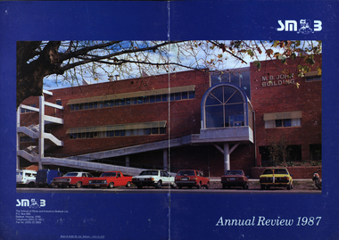
Booklet - Annual Review, Ballarat School of Mines Annual Review, 1986 -1991
... annual review with an aerial photograph over Albert Street... annual review with an aerial photograph over Albert Street ...The Ballarat School of Mines was established in 1870 through the initiatives of the Ballarat Mining Board making it the oldest site of technical education in Australia. The Board was concerned with the shortage of mine managers for the goldfields. Classes began in surveying, mathematics, and chemistry and a decade later they included metallurgy , assaying and geology. With the decline in goldmining the direction of the college changed and broadened, the art School was established and the Ballarat Junior Technical School developed. In 1976, the tertiary sector seperated from the School of Mines and Industries Ballarat to form the Ballarat College of Advanced Education. In the 1980s SMB was a Community College of Technical Education and Further Education (TAFE) offering a wide range of vocational, enrichment and preparatory programs. It is continuing the tradition of providing for the educaiton needs of people within the Central Highlands. During the 1970s and 80s it acquired and refurbished old buildings and developed new facilities to keep up with the needs of an expanding curriculum and student population. The era of these annual reports is just before the merger with the University of Ballarat.A number of soft card covered annual report for the Ballarat School of Mines. .1) 12 page black covered report featuring an image of the E.J. Tippett Library. Includes information on death of E.J. Tippett, disability policy, Peter Quinn, Patti McNulty, Bob Feary, Shane Everand, Integration, Fiona Watson, retirement of Robert Morgan, Opening of the carpentry and Joinery Facility in Davey Street, formation of the School of Business and Information Technology, Melissa Bone, opening of the E.J. T. Tippett Learning Resource Centre (Library), Refurbishment of the Administration Building, Food Service Building (Prospects), Court House Theatre, Enrolment centre, Museum, Creche, Women's Trade technical Program, Rural Education Program, Ararat Prison Program, Community Studies Section, Ararat Adult Literacy Group. Literacy Assistance for Undergraduates, Fire training, fitness, open Learning, Training & Employment Group, Awards, Filipino Visitors, oil Seed Research, Brunei, Barometer (gift) for Horticulture, Special Equipment (guillotine and brake press; programmable logic Controller; theodolite: laser lever; Universal testing Machine; Atomic Absorption Spectrophotometer)., organisational Structure. Photos include Ken Flecknoe, Peter Quinn, Patti McNulty, Bob Feary, Shane Everard, Fiona Watson,Linda Bland, Robert Morgan, David McCaughey, E.J. Tippett, Frank Sheehan, Julie Baulch, Jo Reeves, Col McCurry, Jenny Garnham .3) Blue covered book with a photograph of the M.B. John Building taken from Albert Street on the cover. Topics include: Ken Flecknoe, Peter Shiells, Ararat Campus, David Haddow, Kevin Martin, Rendle Hannah, Gary Eason, Geoff Pope, Albert Peart, M.B. John building opened, Hairdressing Salon, Community Centre, Creche, closure of Lydiard Street, Museum, Jenny Levison, Inskill, Small Business Training, Ballarat Eat free Library, Barkly Street, Wormalds Valve Group, Aboriginal Programs, Horticulture Center, Awards, Country fire Authority, tractor Donation, Women's Policy. Special purchases included surveying equipment with data recorder, test rig , CDT MIG welder, compact gas chromatograph with FID and single pen recorder, Olivetti stand-alone word processing unit. Images include Ken Flecknoe. Peter Shiells, John Crowe, Trevor Slater, Brian McLennan, Kerrie Cross, Albert Peart, John Cain, M.B. John, Enrollment Centre, Museum, Jo Watson, Wormalds, Brian Webber, Dianna Nikelson, Ian Aitken, Brendan B, Chez Dichiera, Heather Dixon, Julie Broadbent .4) 1993 - Brown and white soft covered annual review featuring students of the Ballarat School of Mines at work. Bill Gribble, Brian McLennan, Peter Shiells Retirement, Robert C. Lovett, Steven Mendelson, Max Palmer, Jenny Gough, Mary Molloy, Barrie Firth, Colin McCurry, Dora Hormann, Organisation Structure, Brewery Acquisition, Humffray Street Primary School, Grant Street Retaining Wall, Neville Bunning Plaque, VCE Plus, Ballarat Small Business centre, Ararat Prison, Ballarat Showgrounds Rotunda, .6) Green covered annual review with an aerial photograph over Albert Street, Ballarat. Content include Kerrie Cross, Peter Shiells. Kenneth Flecknoe Obituary, Ian Pimblett, Keith Boast, David Nicholson, Max Palmer, Brian Webber, Bob Lovett, Linda Bland, Prospects, Training restaurant, 3BBB, Malcolm Vallance, Aboriginal Programs, Ian Cathie, Koorie Support Unit, Caroline Hogg, 'Trained Men Make Their Own Terms' exhibition at the Gold Museum, Ricky Hains, Stephen Hughes, Jeff White, Dennis Bolster .8) Blue covered review for 1989. The contents include: Kerrie Cross, Peter Shiells, Ann McCaffrey, Kevin Alsop, Mary Molloy, Ross Furness, Robert Lovett, Victoria Street Student Hostel, Hugh Beggs, Ballarat Small Business Centre, Inskill, Ararat Campus, Hospitality and Tourism, Koorie Support Unit, Fiona Warsn, Bruce Staley, Terry Moran, Anthony Wonish, Ivan Deveson, Leo Shannon Memorial Award, Bryan Crebbin, Geoff Howard, R.C.W. Burdett, Jeff White, Ian Harris, Tom Wiseman, Bill Gribble, Allison Kay, Steven Mendelson, Keith Boast. .9) Grey covered book with a coloured photo of the Victoria Street Student Residence. Contents include: Kerry Cross, Peter Shiells, Morgan Bevan John Illuminated address. Jean Phillips, Koorie Support Unit, Andrew Sullivan, Victoria Street Student Residence, Horticulture, Inskill, Tertiary Awareness Project, Adult Education, Ivan Deveson, Brian Howe, Barry Jones, Joan Kirner, Andrew Trigg, Warren Perry, Murrell Rock Collections, Gwyn Hanssen-Piggott, Disability Awareness Day, Sebastopol Borough Logo, Phoebe Rimmer, Russell Jackson, R.J. Young Scholarship, Peter Muir, Founders Day Cake, Morgan John. .11) Black card covered booklet with five images of exteriors of the Ballarat School of Mines. the contents include: Jack Barker, Peter Shiells, Peter Ellyard, Ian Stoney, Terry Moran, Wayne Strong, David Ince, Simone Titheridge, Ian Aitken,Kevin Alsop, Bill Bridges, Clive Carmichael, Bob Feary, Rendle hannah, Roly Parfenovics, Graham Snibson, Kevin Stockdale, Len Wilson, Child Care Centre opening, Student accommodation, Victoria Street, Brewery site. naming buildings, E.J. barker. A.W. Steane K.J. Flecknow, Carpentry and joinery, Inskill, Hospitality, Pottery, ceramics, Founders' Day, Warren Perry, Agreement between Ballarat School of Mines and Ballarat university College, merger, Peter Baldwin, Awards, obituary Lindsay Hillman. Images include: Wayne Strong, David Ince, Simone Titheridge, kerrie Cross, Joan Kirner, Frank Sheehan, Bill Gribble Ros Wilkie, Judi O'Loughlin, Tony Leonard, Gemma Hearnes, Brendan Hill, Joanne Bell, Karl Moon, Stella Savy, Shirley Falkinder, Peter Baldwin, Jack Barker, Michael Ronaldson, David Kemp, Peter Shiells, Margot Healey, Sharon McLennan, Kerrie Firns, Petrena Brookers, Deb Goudappel, Claire Bond, Administration Building Lindsay Hillman. .13 ) Brown covered report with photographic images. Content includes: Pam Merrett. , Peter Shiells, Robert Lovett, Steven Mendelson, Max Palmer, Jenny Gough, Barrie Firth .14) Brown covered report with photographic images. Content includes: .15) Green covered report with photographic images. The blond woman standing on the right looking at a computer screen is Pam Merrett. Content includes: Bill Gribble, Ron Wild, Doug Sarah, Martin Hill, John Kemp, David Manterfield, Leslie Comy, Linette Penhall, Glen Martland. Virginia Fenelon. Michael Bracher, Brewery Building. Child care centre, Prospects Cafe Opening, Horticulture Training Centre, Retaining Wall, The Gordon, University of Ballarat and Ballarat School of Mines affiliation, Geoffrey Blainey, Ararat Community College Memo of understanding, Brian McLennan. Founders Day (Hadden Storey), Gwyn Hanssen-Pigott, Ken Latta, Neville Bunning Outstanding Achievement Award, Valerie Wilson, Jack Barker, John Sharpham, Jack Barker Resignation.ballarat school of mines, university of ballarat, integration, shane everard, robery morgan, linda bland, ballarat junior technical school, former court house, ken flecknoe, bruce muir, lindsay hillman, neil crouch, jack barker, keith boast, rex hollioake, m.b. john, bob lovett, brian mclennan, peter shiells, bruce tanner, jeff white, bryan crebbin, kerrie cross, ric dunlop, tom wiseman, barbara hughes, chris matheson, morgan b. john, albert street, steven mendelson, john crowe, ann mccaffrey, kevin alsop, mary molloy, ross furness, robert lovett, victoria street student hostel, student residences, hugh beggs, ballarat small business centre, inskill, ararat campus, hospitality and tourism, koorie support unit, fiona watson, bruce staley, terry moran, anthony wonish, ivan deveson, leo shannon memorial award, geoff howard, r.c.w. burdett, ian harris, bill gribble, allison kay, liz eddy, pam merrett, doug sarah, martin hill, john kemp, david manterfield, leslie comy, linette penhall, glen martland, virginia fenelon, michael bracher, brewery building, child care centre, prospects cafe, horticulture training centre, retaining wall, the gordon, university of ballarat and ballarat school of mines affiliation, geoffrey blainey, ararat community college memo of understanding, founders day, hadden storey, gwyn hanssen-pigott, ken latta, neville bunning outstanding achievement award, valerie wilson, john sharpham, kerry cross, morgan bevan john illuminated address, jean phillips, andrew sullivan, victoria street student residence, horticulture, inskill, tertiary awareness project, adult education, brian howe, barry jones, joan kirner, andrew trigg, warren perry, murrell rock collections, gwyn hanssen-piggott, disability awareness day, sebastopol borough logo, phoebe rimmer, russell jackson, r.j. young scholarship, peter muir, kenneth flecknoe obituary, ian pimblett, david nicholson, brian webber, prospects, training restaurant, 3bbb, malcolm vallance, aboriginal programs, ian cathie, caroline hogg, 'trained men make their own terms' exhibition at the gold museum, ricky hains, stephen hughes, dennis bolster, aboriginal education, e.j. tippett obituary, patti mcnulty, bob feary, equal opportunity officer, robert c. morgan, school of business and information technology, e.j. tippett library, e.j. tippett library opening, carpentry and joinery, women's trade and technical program, rural education program, ararat prison program, barometer, oil seed research, . bill gribble, peter shiells retirement, robert c. lovett, max palmer, jenny gough, barrie firth, colin mccurry, dora hormann, organisation structure, brewery acquisition, humffray street primary school, grant street retaining wall, neville bunning plaque, vce plus, ararat prison, ballarat showgrounds rotunda -
 The Beechworth Burke Museum
Photograph, 1960
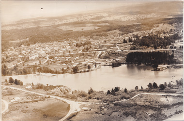
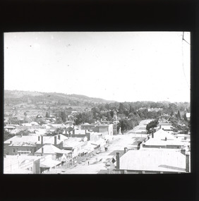
Taken in 1960, depicted is an aerial view of Lake Sambell and the surrounding township. Lake Sambell is a beautiful Victorian recreation lake and urban park with a unique history. It was created in the mid-1800s by the Rocky Mountain Mining company during the gold rush era and used as a mining site until the early 1900s, which brought Europeans into the area. It was turned into a reserve for residents in 1920 and is considered an icon of Beechworth as it represents the development of the community, human endeavour, and the spirit of the landscape.This photograph represents what Lake Sambell looked like in 1960.Black and white reproduced rectangular photograph print on paper.lake sambell, #beechworth, beechworth 1960s, lake, victoria, australian landscape, mining, rocky mountain mining company -
 The Beechworth Burke Museum
Photograph, Unknown
Aerial view of Lake Sambell, Beechworth with town views. Lake Sambell is a beautiful Victorian recreation lake and urban park with a unique history. It was created in the mid-1800s by the Rocky Mountain Mining company during the gold rush era and used as a mining site until the early 1900s, which brought Europeans into the area. It was turned into a reserve for residents in 1920 and is considered an icon of Beechworth as it represents the development of the community, human endeavour, and the spirit of the landscape.This photograph represents Lake Sambell with town views.Black and white reproduced rectangular photograph print on paper.Reverse: Stampbeechworth lake, lake sambell, aerial photo, construction, australian landscape, #beechworth, victoria -
 The Beechworth Burke Museum
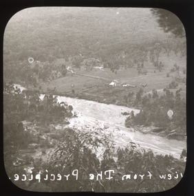
Photograph - Lantern Slide, c1900
This image shows a semi-aerial view of a property along a river adjacent to Beechworth in approximately 1900. The photographer has capitalised words in the label, indicating that 'The Precipice' may have suggested a particular rather than a general vantage point to local people at the time. Although the exact location of the photograph is yet to be determined, Beechworth Gorge is popular today with hikers and nearby Mt Stanley is noted for its views. Lantern slides, sometimes called 'magic lantern' slides, are glass plates on which an image has been secured for the purpose of projection. Glass slides were etched or hand-painted for this purpose from the Eighteenth Century but the process became more popular and accessible to the public with the development of photographic-emulsion slides used with a 'Magic Lantern' device in the mid-Nineteenth Century. Photographic lantern slides comprise a double-negative emulsion layer (forming a positive image) between thin glass plates that are bound together. A number of processes existed to form and bind the emulsion layer to the base plate, including the albumen, wet plate collodion, gelatine dry plate and woodburytype techniques. Lantern slides and magic lantern technologies are seen as foundational precursors to the development of modern photography and film-making techniques.This glass slide is significant because it provides insight into Beechworth's built environment and natural landscape in the early Twentieth Century, around the time of Australia's Federation. It is also an example of an early photographic and film-making technology in use in regional Victoria in the time period.Thin translucent sheet of glass with a square image printed on the front and framed in a black backing. It is held together by metals strips to secure the edges of the slide.Obverse: Image from The Precipice. /burke museum, beechworth, lantern slide, slide, glass slide, plate, burke museum collection, photograph, monochrome, views, landscapes, farmsteads, rivers, beechworth gorge, mt stanley, emulsion, the precipice -
 The Beechworth Burke Museum
Photograph - Lantern Slide, c1900
This image shows a semi-aerial view of commercial and official properties lining Ford Street, Beechworth, in approximately 1900. The tower of Christ Church of St Peter and St Paul can be seen in the middle section of the photograph, on the left-hand side of the street. The Church was constructed in 1858 with the tower added to the structure in 1864. Lantern slides, sometimes called 'magic lantern' slides, are glass plates on which an image has been secured for the purpose of projection. Glass slides were etched or hand-painted for this purpose from the Eighteenth Century but the process became more popular and accessible to the public with the development of photographic-emulsion slides used with a 'Magic Lantern' device in the mid-Nineteenth Century. Photographic lantern slides comprise a double-negative emulsion layer (forming a positive image) between thin glass plates that are bound together. A number of processes existed to form and bind the emulsion layer to the base plate, including the albumen, wet plate collodion, gelatine dry plate and woodburytype techniques. Lantern slides and magic lantern technologies are seen as foundational precursors to the development of modern photography and film-making techniques.This glass slide is significant because it provides insight into Beechworth's built environment and commercial and official infrastructure in the early Twentieth Century, around the time of Australia's Federation into one nation. It is also an example of an early photographic and film-making technology in use in regional Victoria in the time period.Thin translucent sheet of glass with a square image printed on the front and framed in a black backing. It is held together by metals strips to secure the edges of the slide.burke museum, beechworth, lantern slide, slide, glass slide, plate, burke museum collection, photograph, monochrome, ford street, christ church of st peter and st paul, church tower, landmarks, 1900, shopping facilities, public buildings, 1900s, built environment, streetscape -
 Orbost & District Historical Society
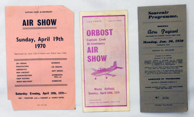
souvenir programs, 1950 ; 1970
Orbost Aero Club began in 1969 with Basil Dowie as Chair, David Nixon as Secretary/Treasurer. The group went into recess from 1977-1991 closing in 1997. The mid 1960s were boom years in flying training in Australia and the number of Aero Clubs grew rapidly. The Club played a significant role in the establishment of the small airport at Marlo and in the ongoing operation and development of the airport over the years particularly for patient transfer by aerial ambulance. The Orbost Aero Club Club played a significant role in the establishment of the small airport at Marlo and in the ongoing operation and development of the airport over the years.Two souvenir programs and one advertising flyer. 2406.27 is a souvenir program for the Orbost Captain Cook Bi-Centenary Air Show 1970. It is purple print on a white background. It has seven folded glossy pages and cost 20c. On the cover is a photograph of a small plane. 2406.28 is a flyer for the Captain Cook Bi-Centenary Air Show, Sunday, April 19th 1970. It is black print on a pink background, 2406.29 is a souvenir program for Morwell Aero Pageant, Monday, January 30, 1950. Cost 3/-. No 4216. It is a grey/brown coloured card folder with black print.2406.28 - on back - Bruce Ham......(?) Yarram Tiger Moth orbost-aero-club captain-cook-bicentenary -
 Orbost & District Historical Society
photographs
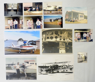
Orbost Aero Club began in 1969 with Basil Dowie as Chair, David Nixon as Secretary/Treasurer. The group went into recess from 1977-1991 closing in 1997. The mid 1960s were boom years in flying training in Australia and the number of Aero Clubs grew rapidly. The Club played a significant role in the establishment of the small airport at Marlo and in the ongoing operation and development of the airport over the years particularly for patient transfer by aerial ambulance. The Orbost Aero Club Club played a significant role in the establishment of the small airport at Marlo and in the ongoing operation and development of the airport over the years.Thirteen photographs related to the Orbost aero Club. Most are coloured. Ten are originals. 2406,33 is of David Nixon in the cockpit of the Bonanza (a small Beechcraft plane). 2406.40 is a photograph of David Nixon's grandfather's desk used for planning flights etc.On back of 2406.33 in blue pen - "This is me in the cockpit of the Bonanza." On back of 2406.34 in blue pen - "Taking Cora for her first flight with me after gaining my pilot's licence 1966."orbost-aero-club nixon_david -
 The Beechworth Burke Museum
Photograph
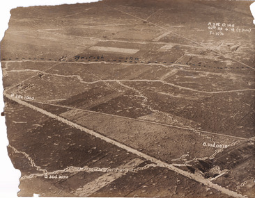
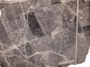
... Taken some time between 1914-18, the photograph depicts...-country Taken some time between 1914-18, the photograph depicts ...Taken some time between 1914-18, the photograph depicts an aerial view of trenches in France. The image mostly shows rural landscape, although there is a house in the bottom right corner. A dotted line has been drawn across the photograph, marking the section of trenches that belonged to British forces during World War I. It is believed that the line marking on this record denotes a section of the Western Front. The Western Front was the main theatre of war during World War I. Following the outbreak of war in August 1914, the German Army opened the Western Front by invading Luxembourg and Belgium, then gaining military control of important industrial regions in France. The German advance was halted with the Battle of the Marne. Following the Race to the Sea, both the French-British and German armies dug in along a meandering line of fortified trenches, stretching from the North Sea to the Swiss frontier with France. Between 1915 and 1917 there were several offensives along the Western Front. The attacks employed massive artillery bombardments and massed infantry advances. Entrenchments, machine gun emplacements, barbed wire and artillery repeatedly inflicted severe casualties during attacks and counter-attacks and no significant advances were made. Among the most notable of these offensives were the Battle of Verdun (1916), the Battle of the Somme (1916), and the Battle of Passchendaele (1917).The record is historically significant due to its connection to World War I. This conflict is integral to Australian culture as it was the single greatest loss of life and the greatest repatriation of casualties in the country's history. Australia’s involvement in the First World War began when the Australian government established the Australian Imperial Force (AIF) in August 1914. Immediately, men were recruited to serve the British Empire in the Middle East and on the Western Front. The record has strong research potential. This is due to the ongoing public and scholarly interest in war, history, and especially the ANZAC legend, which is commemorated annually on 25 April, known as ANZAC Day.Sepia rectangular photograph printed on matte photographic paper.Obverse: A.3FE.O.146 / G2R 29 . 6 . 18 (Y p.m) / F= 10 1/4 / British Line / ------------------------------------------ / P. 250 1040 / 0. 30d. 0010 / 0. 30d. 3070 /military album, military, war, wwi, world war i, france, great britain, trenches, village, rural, western front -
 The Beechworth Burke Museum
Photograph
... Taken some time between 1914-18, the photograph depicts...-country Taken some time between 1914-18, the photograph depicts ...Taken some time between 1914-18, the photograph depicts an aerial view of trenches in France. The image mostly shows rural landscape, although there is a cluster of houses in the top right corner. It is believed that this record denotes a section of the Western Front. The Western Front was the main theatre of war during World War I. Following the outbreak of war in August 1914, the German Army opened the Western Front by invading Luxembourg and Belgium, then gaining military control of important industrial regions in France. The German advance was halted with the Battle of the Marne. Following the Race to the Sea, both the French-British and German armies dug in along a meandering line of fortified trenches, stretching from the North Sea to the Swiss frontier with France. Between 1915 and 1917 there were several offensives along the Western Front. The attacks employed massive artillery bombardments and massed infantry advances. Entrenchments, machine gun emplacements, barbed wire and artillery repeatedly inflicted severe casualties during attacks and counter-attacks and no significant advances were made. Among the most notable of these offensives were the Battle of Verdun (1916), the Battle of the Somme (1916), and the Battle of Passchendaele (1917).The record is historically significant due to its connection to World War I. This conflict is integral to Australian culture as it was the single greatest loss of life and the greatest repatriation of casualties in the country's history. Australia’s involvement in the First World War began when the Australian government established the Australian Imperial Force (AIF) in August 1914. Immediately, men were recruited to serve the British Empire in the Middle East and on the Western Front. The record has strong research potential. This is due to the ongoing public and scholarly interest in war, history, and especially the ANZAC legend, which is commemorated annually on 25 April, known as ANZAC Day.Black and white rectangular photograph printed on matte photographic paper.Obverse: A.3.FE.2.291 / 62D O.20bd.P.25O.C / 16.7.18 / 12 / F 8 1/4 / Reverse: 6532military album, military, army, war, wwi, world war i, france, trenches -
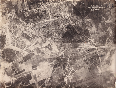 The Beechworth Burke Museum
Photograph
... Taken some time between 1914-18, the photograph depicts...-country Taken some time between 1914-18, the photograph depicts ...Taken some time between 1914-18, the photograph depicts an aerial view of Villers-Bretonneux in France, a region which was part of the Western Front during World War I. The image mostly shows rural landscape. The Western Front was the main theatre of war during World War I. Following the outbreak of war in August 1914, the German Army opened the Western Front by invading Luxembourg and Belgium, then gaining military control of important industrial regions in France. The German advance was halted with the Battle of the Marne. Following the Race to the Sea, both the French-British and German armies dug in along a meandering line of fortified trenches, stretching from the North Sea to the Swiss frontier with France. The First Battle of Villers-Bretonneux occurred between 30 March - 5 April 1918. It took place during Operation Michael, part of the German Spring Offensive on the Western Front. The offensive began against the British Fifth Army and the Third Army on the Somme, and pushed back the British and French reinforcements on the north side of the Somme. The capture of Villers-Bretonneux, close to Amiens, a strategically important road and rail-junction, would have brought the Germans within artillery-range. In late March, troops from the Australian Imperial Force were brought south from Belgium as reinforcements to help shore up the line. In early April, the Germans launched an attack to capture Villers-Bretonneux. After a determined defence by British and Australian troops, the attackers were close to success until a counter-attack by the 9th Australian Infantry Brigade and British troops late in the afternoon of 4 April restored the situation and halted the German advance on Amiens. The Second Battle of Villers-Bretonneux occurred between 24 - 27 April 1918, during the German Spring Offensive to the east of Amiens. It is notable for being the first occasion on which tanks fought against each other. A counter-attack by two Australian brigades and a British brigade during the night of 24 April partly surrounded Villers-Bretonneux, and on 25 April, the town was recaptured. On 26 April, the role of the Moroccan division of the French army was crucial in pushing back German units. Australian, British and French troops nearly restored the original front line by 27 April.The record is historically significant due to its connection to World War I. This conflict is integral to Australian culture as it was the single greatest loss of life and the greatest repatriation of casualties in the country's history. Australia’s involvement in the First World War began when the Australian government established the Australian Imperial Force (AIF) in August 1914. Immediately, men were recruited to serve the British Empire in the Middle East and on the Western Front. Additionally, the record's significance is enhanced by its depiction of Villers-Bretonneux. The battles that occurred in this town during World War I are especially historically significant to Australia as this is where the Australian Imperial Force had one their greatest World War I victories. An Australian flag still flies over Villers-Bretonneux in the present. Furthermore, a plaque outside the Villers-Bretonneux Town Hall recounts the battles fought to save the town in 1918. Kangaroos feature over the entrance to the Town Hall, and the main street is named Rue de Melbourne. More officially, recognition of the significance of the battle in Villers-Bretonneux is found at the Australian National Memorial, which was built just outside the town. It commemorates all Australians who fought in France and Belgium and includes the names of 10,772 who died in France and have no known grave. Each year, a small ceremony is held at the memorial to mark the sacrifice made by the soldiers. Lastly, the record has strong research potential. This is due to the ongoing public and scholarly interest in war, history, and especially the ANZAC legend, which is commemorated annually on 25 April, known as ANZAC Day.Sepia rectangular photograph printed on matte photographic paper.Obverse: yAE.2.35. / 125 / 62d.2834.35.36.VA.5. / 12.G.18-11 / F.-(?)" /military album, wwi, world war i, villers-bretonneux, australian imperial force, aif, france, war, army, conflict, germany, 1918, battle -
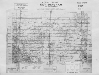 The Beechworth Burke Museum
Photograph - Aerial Survey, 5/9/1947
... -printed border. Photograph Aerial Survey ...This image is an Aerial Survey, Key Diagram of Beechworth and surrounding area. Issued by Department of Lands and Survey, Victoria in 1947. Photographed at an average height of 12300 feet above sea level, areas depicted are; Beechworth, Stanley, Bruarong, Baranduda, Muagegonga, Myrtleford, Everton, Wooragee North Tarrawinge, Dederang, Kergunyah North, Kergunyah, Yackandandah, El-Dorado, Barambogie, Murmungee, Barwidgee, Oxley, CarraragarmungeeBlack and white rectangular photograph. Image is printed on matt photographic paper and has a white un-printed border. Obverse: AERIAL SURVEY, KEY DIAGRAM OF PHOTOGRAPHS, APPROXIMATE SCALE OF MILES / DEPARTMENT OF LANDS AND SURVEY VICTORIA 5.9.1947. BEECHWORTH 792 ZONE 7. Reverse: BMM7010.1 (written in pencil) aerial survey, beechworth, burke museum, department of lands and survey, victoria, 1947 -
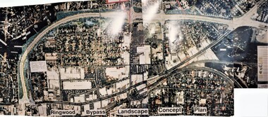 Ringwood and District Historical Society
Photograph, Ringwood Bypass Landscape Concept Plan
Three colour phototraphs forming composite panoramic aerial view (undated)."Ringwood Bypass Landscape Concept Plan" -
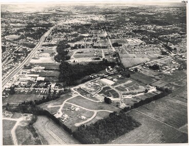 Ringwood and District Historical Society
Photograph, Aerial View of Ringwood, Victoria - circa 1970
Black & white west-facing view over Oban Road along Mullum Mullum Road and Creek. Foreground showing early subdivision development of "Dunn's Orchard Estate" with formation of Frederic Drive (named after the orchardist - Frederic Dunn), Baron Court, Towerhill Drive, Tyson Court, Adele Court, Marilyn Crescent, Abbey Court, Highland Boulevard, Ailsa Court.