Showing 1795 items matching "bushfires or Black Saturday or wildfire or Ash Wednesday fires"
-
 Eltham District Historical Society Inc
Photograph, A walk through the cemetery at Kangaroo Ground, Diana Bassett-Smith, 1 October 2001, 2001
A huge warrior of a gum tree still stands sentinel at the wrought iron gates. In the distance some pencil pines. Survivors too of the disastrous bushfires which in the past have swept the district. A brief collection of reminiscences by Diana Bassett-Smith of locals who are buried at Kangaroo Ground Cemetery along with 17 photographs following a visit on 1 October 2001.Colour photograph print1983 bushfire, air vice marshall wackett, ambrose erswell, barry roach-pierson, bill pelling, billy roach-pierson, birrarung, bourchiers road, ca 13, crichton, david grant, diamond street, diana bassett-smith, donald grant, donaldson road, dorrie bourchier, duff, early settlers, elizabeth cottee, ewan cameron mp, grey house, helen kohn, isabella grant (nee stevenson), jack bourchier, james balfour, james wilson, jean stewart, jessie bull (nee haughton), jimmy cook, jocelyn, joseph stevenson, judge book village, judith furphy, kangaroo ground cemetery, kay roach-pierson, keith jocelyn, kraft foods, lacey, lloyd stuart, louise grant (nee gordon), mardi crocker, marion erswell, ned haughton, nursery, pam chevallier, passiona, peter bassett-smith, pigeon bank, rath, ricketson, robinson, ruth boyd, steven crawford baes, tintagell, tosch, vera jackson, wackett trainer, watershed jackson, willandra poultry farm, zac crocker -
 Eltham District Historical Society Inc
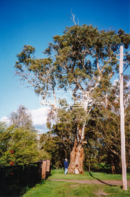
Newsletter, Newsletter, No. 217 July 2014
Contents: • Fabbro Fields • Next Meeting • Heritage Excursion – Walter Withers drive yourself excursion • July Meeting – Montmorency; The farm on the Plenty • July Excursion • Benjamin Wallis; a prominent early Eltham resident by Russell Yeoman • Fire • Local Bushfire History • Facebook by Jim Connor • Member Subscriptions • And Also • Contacts for the Eltham District Historical Society The Shire of Eltham Historical Society was formed in October 1967. The first newsletter of the Society was issued May 1978 and has been published continuously ever since on a bi-monthly basis. With the cessation of the Shire of Eltham in late 1994, the Society's name was revised to Eltham District Historical Society and this name first appeared with issue No. 103, July 1995. The collection of the Society's newsletters provides a valuable resource on the history of the Society's activities, office bearers and committee members, guest speakers and subjects of historical interest pertinent to the former Shire of Eltham and the Eltham District.A4 photocopied newsletter distributed to membersnewsletter, eltham district historical society, shire of eltham historical society -
 Bendigo Historical Society Inc.
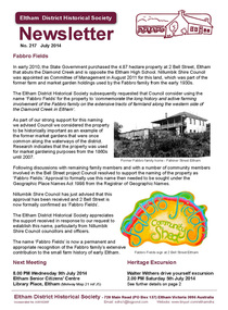
Newspaper - NEWSPAPER COLLECTION: BENDIGO ADVERTISER - HERALD SUN 2009 BUSHFIRES
... BUSHFIRES... Sun - Black Saturday - February 07, 2009 4) Herald Sun - Fire...-July 03, 2009 3) Herald Sun - Black Saturday - February 07 ...1) The Advertiser - Red Alert - February 06, 2009 2) The Advertiser - Headline Moments of the Past-July 03, 2009 3) Herald Sun - Black Saturday - February 07, 2009 4) Herald Sun - Fire-storm - February 08, 2009 5) Herald Sun - 84 Dead - February 09, 2009 6) Herald Sun - We'll Help - February 09, 2009 7) The Advertiser - Hellfire Heartache - February 09, 2009 8) The Advertiser - Thumbs Up On Water - February 09, 2009 9) Herald Sun - We Will Rebuild - February 10, 2009 10) Herald Sun - All Lost - February 10, 2009 11) The Advertiser - How We Lost Our Brother - February 10, 2009 12) The Advertiser - Counting the Cost - February 10, 2009 13) Herald Sun - Alive - February 11, 2009 14) Herald Sun - Act of Terror - February 11, 2009 15) Herald Sun - Never Again - February 12, 2009 16) Herald Sun - The Tiniest Victims - February 12, 2009 17) Herald Sun - Heart of a Nation - February 13, 2009 18) Bendigo Weekly - City Unites - February 13, 2009 19) Herald Sun - Love from the Ashes - February 14, 2009 20) The Advertiser - Black Saturday - February 14, 2009 21) The Advertiser - Black Saturday - February 14, 2009 22) Herald Sun - Portraits of Grief - February 14, 2009 23) Herald Sun - Salute Our Heroes - February 15, 2009 24) The Advertiser - One Brick at the Time - February 16, 2009. Folder 111 now in Box 417 AV 03/11/2022newspaper, bendigo advertiser -
 Eltham District Historical Society Inc
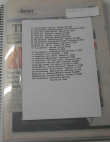
Negative - Photograph, Log bridge over Pheasant Creek, Kinglake, c.1920
Postcard view of pedestrian log bridge in Kinglake National Park. The log bridge over Johnston's Creek is said to have been built to allow the timber tramline to cross the creek. The bridge was destroyed in the 1926 bushfires. Other sources describe this bridge being located at Pheasant Creek (between Kinglake West and Kinglake Central) and that it was built by Mr Munro, the owner of the sawmill.This photo forms part of a collection of photographs gathered by the Shire of Eltham for their centenary project book,"Pioneers and Painters: 100 years of the Shire of Eltham" by Alan Marshall (1971). The collection of over 500 images is held in partnership between Eltham District Historical Society and Yarra Plenty Regional Library (Eltham Library) and is now formally known as 'The Shire of Eltham Pioneers Photograph Collection.' It is significant in being the first community sourced collection representing the places and people of the Shire's first one hundred years.Digital image 4 x 5 inch B&W Neg 1 printshire of eltham pioneers photograph collection, kinglake, log bridge, bridge, mr. munro, timber tramway, pheasant creek -
 Eltham District Historical Society Inc
Album - Photograph, J.A. McDonald, Salters Rush Road, Smiths Gully, Aug. 1962
... bushfires...bushfires ...Salters Rush Road, Smiths Gully Burnt out culvert following bush fires 15-16 Jan. 1962Record of various Shire of Eltham infrastructure works undertaken during the period of 1952-1962 involving bridge and road reconstruction projects, sometimes with Eltham Shire Council Project Reference numbers quoted. It was during this period that a number of significant improvements were made to roads and new bridges constructed within the shire that remain in place as of present day (2022). In many situations, the photos provide a tangible visible record of infrastructure that existed throughout the early days of the Shire. The album was put together by or under the direction of the Shire Engineer, J.A. McDonald.H941 stamped on reverse (film processing #)infrastructure, shire of eltham, bridge construction, road construction, 1962-08, bushfires, salters rush road, smiths gully, victorian bushfires - 1962 -
 Eltham District Historical Society Inc
Album - Photograph, J.A. McDonald, Salters Rush Road, Smiths Gully, Aug. 1962
... bushfires...bushfires ...Salters Rush Road, Smiths Gully Bridge over Salters Rush Creek following bush fires 15-16 Jan. 1962Record of various Shire of Eltham infrastructure works undertaken during the period of 1952-1962 involving bridge and road reconstruction projects, sometimes with Eltham Shire Council Project Reference numbers quoted. It was during this period that a number of significant improvements were made to roads and new bridges constructed within the shire that remain in place as of present day (2022). In many situations, the photos provide a tangible visible record of infrastructure that existed throughout the early days of the Shire. The album was put together by or under the direction of the Shire Engineer, J.A. McDonald.H941 stamped on reverse (film processing #)infrastructure, shire of eltham, bridge construction, road construction, 1962-08, bushfires, salters rush road, smiths gully, victorian bushfires - 1962 -
 Eltham District Historical Society Inc
Album - Photograph, J.A. McDonald, Black Cameron Road, Smiths Gully, Aug. 1962
... bushfires...bushfires ...Black Cameron Road Bridge over Salters Rush Creek following bush fires 15-16 Jan. 1962Record of various Shire of Eltham infrastructure works undertaken during the period of 1952-1962 involving bridge and road reconstruction projects, sometimes with Eltham Shire Council Project Reference numbers quoted. It was during this period that a number of significant improvements were made to roads and new bridges constructed within the shire that remain in place as of present day (2022). In many situations, the photos provide a tangible visible record of infrastructure that existed throughout the early days of the Shire. The album was put together by or under the direction of the Shire Engineer, J.A. McDonald.H941 stamped on reverse (film processing #)infrastructure, shire of eltham, bridge construction, road construction, 1962-08, bushfires, victorian bushfires - 1962, black cameron road, smiths gully -
 Southern Sherbrooke Historical Society Inc.
Information folder - Charles Hammond
... bushfires...bushfires ...Photocopies of watercolours reproduced in book "Charlie Hammond's Sketchbook", showing scenes in the Dandenong Ranges, early 1900s. -article, "Library gains a colonial treasure", Age, 17 July 1987, 2 copies, re. acquisition of Hammond sketchbooks by State Library of Victoria -photocopy of first two pages from book, Charles Hammond's Sketch-book.dandenong ranges, bushfires, belgrave, tecoma, puffing billy, coles nursery, nathania springs, sherbrooke falls, dandenong reservoir -
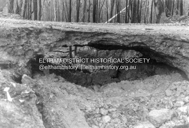
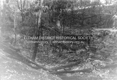
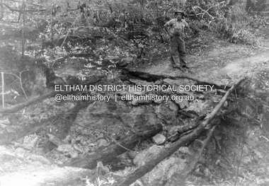
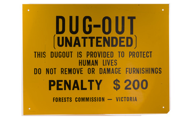 Forests Commission Retired Personnel Association (FCRPA)
Dugout sign, Post 1966
Considered in terms of both loss of property and loss of life, the Black Friday bushfires on 13 January 1939 were one of the worst disasters to have occurred in Australia and certainly the worst bushfire up to that time. The fires burnt 2 million hectares, 69 sawmills were destroyed, 71 people died, and several towns and sawmills were entirely obliterated. Among those killed were four men from the Commission The subsequent Royal Commission conducted by Judge Leonard Stretton has been described as one of the most significant inquiries in the history of Victorian public administration. Its recommendations led to sweeping changes. In addition to building dams and water points, the Stretton Royal Commission recommended expanding and controlling the use of bushfire dugouts at forest sawmills. Well-constructed dugouts had saved the lives of many sawmill workers and their families during the 1939 bushfires. But in some locations, they had proved fatal. Dugouts became mandatory for those few sawmills that remained in the forest after the 1939 fires. Many remote logging coupes and FCV roading camps also had dugouts. The local District Forester was required to make annual pre-season inspections of all dugouts on State forests and those within the Fire Protected Area (FPA). Some were built privately on private land. Most were primitive construction with a log or corrugated iron roof covered with earth. A hessian bag often hung at the entrance to keep the heat and smoke out. But they were dark and damp with snakes and other creepy crawlies often lurking inside. By 1940-41 there were 19 new dugouts constructed by the Commission and a further 128 by forest licensees. Ten years later there were 8 new Commission dugouts and 21 new ones built by other interests. By 1960-61 the rate of new builds was declining but the Commission still managed 103 dugouts while 127 were looked after by others. However, as the forest road network improved and gave all-weather access to modern two-wheel-drive vehicles the reliance on dugouts receded.Large metal sign that was positioned near forest dugoutsbushfire, forest signs, forests commission victoria (fcv) -
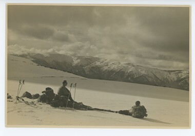 Falls Creek Historical Society
Photograph - Bogong Trip 1951- Mt. Bogong from above Roper's Hut
MEYER COLLECTION - FALLS CREEK PHOTOS In 1947 a determined group of like-minded State Electricity Commission (SEC) staff including Ray Meyer, the chief surveyor of the Kiewa Hydro-Electric Scheme, had a common interest that revolved around the skiing potential of the snow-covered high plains which included what is now the resort of Falls Creek. The six SEC employees, Toni St Elmo, Ray Meyer, Jack Minogue, Lloyd Dunn, Adrian Ruffenacht and Dave Gibson (together with their families) banded together to secretly build a 'hut' that was the first ski lodge at Falls Creek. Using a road built in 1930s to gain access to Falls Creek, their hut project was carried out in secret as efforts by other skiers were blocked by H.H.C. Williams – the engineer in charge of the Hydro Scheme. In 1946 Ray Meyer made a trip to the Lands Office in Melbourne. He came away with a 99-year lease on three acres that was ideally suited for a hut designed by Lloyd Dunn. Adrian Ruffenacht (Design Engineer for the KHS) had suggested where the group should build because of easy access to a spring for water. Much of the building material required was scavenged from derelict huts on the high plains. Due to the need for secrecy, the determined group worked on the hut in the evenings and weekends to avoid detection. During the building period the group had met at Echidna Rock (now known as Eagle Rock) where Skippy St Elmo announced, "This is my favourite ‘Skyline’.” And so the first lodge in the area at Falls Creek Ski Resort came into existence. With the development of the International Poma in the 1970s, the Skyline Lodge, which was sited between the ski-lift’s pole one and pole two, was demolished. However, the legacy of Ray Meyer, Toni St Elmo, Jack Minogue, Lloyd Dunn, Adrian Ruffenacht and Dave Gibson and Skyline lives on in the vibrant atmosphere of Falls Creek Resort. The MEYER COLLECTION documents developments on the Kiewa Hydro Scheme and their life at Falls Creek from the mid 1930s to 1960s.This image is significant because it depicts aspects of the life of a pioneering family of Falls Creek and the founders of "Skyline", the first lodge at Falls Creek.Black and White Image of Mt. Bogong from above Roper's Hut with Wal Johnson and Ray Meyer seated on the ground. ROPER'S HUT Frederick Roper and his family grazed the Bogong High Plains from the 1890s until 1908. Frederick "Jack" built three huts. The hut known as Roper’s Hut was built on Jack's new grazing lease after his former run had been acquired by the SEC in the late 1930s. It had become a well-used refuge hut prior to its destruction in the 2003 bushfires. It was rebuilt by Victorian High Country Huts Association in 2008.falls creek, bogong high plains, wal johnson, ray meyer, ropers hut -
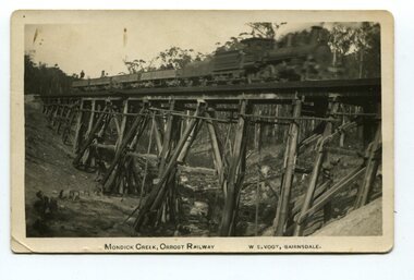 Orbost & District Historical Society
black and white photograph, Vogt. W.S, first half 20th century
This 97km Bairnsdale to Orbost extension through rugged terrain was reputed to have been the most difficult rail project undertaken in Victoria. This wooden bridge was one of the unique railway bridges of the East Gippsland Railway line. Mundic Creek Bridge is of unique design because the line crosses at a very sharp angle. This bridge like many others on the line have "disappeared". This one, probably because of a bushfire.The Bairnsdale to Orbost rail line contains the most varied range Of timber & timber composite bridges on any Victorian line. This photograph is a record of that. A black / white photograph of a train on a wooden railway bridge at Mundic Creek.on front - Mundic Creek, Orbost Railway W.S.Vogt, Bairnsdalemundic-creek-bridge east-gippsland-railway -
 Eltham District Historical Society Inc
Document - Folder, Warrandyte Bushfire Relief, 1962
... Victorian Bushfires - 1962 ...Following the January 1962 bushfires in Warrandyte, affected land holders and residents made application for financial assistance. These records are a small part of more than 1,300 applications made at the time. Contents include: Approximately 200 applications for assistance which include details of property, residence (holiday, farm holding, main residence), residents and property loss Approximately 500 Council responses for each application Miscellaneous correspondencePovides a clear description of property ownership, type, size, holdings and people at the timeapplication form, assessments, bushfire relief, eltham shire council, north warrandyte, scan - tbd, victorian bushfires - 1962, warrandyte -
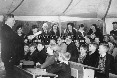 Eltham District Historical Society Inc
Photograph, The Age, Mr. William H. Everard, M.L.A. addressing children at South Warrandyte Primary School, 30 Jun 1939
South Warrandyte State School was destroyed in the Black Friday bushfire of 13 Jan. 1939. Whilst a new school building was being constructed, classes were conducted in a tent as seen in this image from 'The Age" of Mr William Everard, M.L.A.delivering his 22nd annual Arbor Day address to children of the school on 30 June 1939. Mr Everard returned on October 7 to officially open the new school.south warrandyte state school, william h. everard, arbor day, black friday -
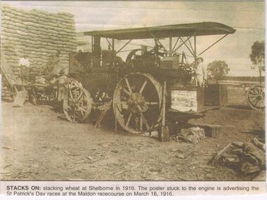 Bendigo Historical Society Inc.
Newspaper - JENNY FOLEY COLLECTION: STACKS ON
The Maldon-Laanacoorie railway line was never completed so Shelbourne became to termination point of this line. The station and railway yards opened in 1891 ad were last used in 1969 after bushfires had destroyed bridges on the line. The advertised St Patrick's Day race meeting was held on Saturday 18th March and a special train for patrons was run form Castlemaine, leaving at 1.15pm and returning at 7pm.Bendigo Advertiser '' the way we were'' from 2002. Stacks on: stacking wheat at Shelborne in 1916. The poster stuck to the engine is advertising the St Patrick's Day races at the Maldon racecourse on March 18, 1916. The clip is in a folder.newspaper, bendigo advertiser, the way we were -
 Vision Australia
Administrative record - Text, Royal Victorian Institute for the Blind annual report 1982-1983, 1982-1983
Activities in annual report include: retirement of Ralph Lightfoot, appointment of Frances Warren, opening of Wangaratta regional office, family group home in second year providing home environment for three children, establishment of self contained flat within residential services at Burwood, bushfires threatened but did not destroy Wahpeton at Romsey and ski lodge at Mt Baw Baw, and support from hotels through 80 Lucky Envelope machines.1 volume of printed material with imagesannual report, royal victorian institute for the blind -
 Parks Victoria - Mount Buffalo Chalet
Cutlery
These pieces of cutlery were found by a Parks Victoria ranger in a hollow log after the 2003 bushfires. It is possible these items were hidden for Chalet guests for picnics when they went out horseriding . There is reference to this practice in the "Mt Buffalo Story" 'Holidaymakers planning all day treks to distant features on the Plateau - Mount Macloed, the Great Wall of China of the Sarcophagus - collecteda packed lunch and anorange." (Pg 88. the Mount Buffalo Story)Listed in Draft Inventory of Significant Collection items. Appendix A.3.Tableware. (Pg 166 Historica).Three stainless steel forks with Victorian Railways insignia. Three stainless steel spoons, two with Victorian Railways insiginia. One stainless steel knife with Victorian Railways insiginia. (knife is burnt)On the two forks,"ALLBRITE STAINLESS STEEL" & "VR" On the two spoons,"ALLBRITE STAINLESS STEEL / VR" On burnt knife,"ALLBRITE FIRTH C....LY STAINLESS, VR" -
 Eltham District Historical Society Inc
Photograph - Digital Photograph, Marguerite Marshall, Strathewen Public Hall, 20 August 2008
... was later lost in the Black Saturday fires 2009. The Strathewen... was later lost in the Black Saturday fires 2009. The Strathewen ...Strathewen Public Hall, social and spiritual centre was later lost in the Black Saturday fires 2009. The Strathewen Community decided a community hall was needed in 1901. In 1902 locals built the hall with messmate trees. It was located on the Cottlesbridge-Strathewen Road. The first function was a Grand concert and Balll attended by about 120 people. Several denominations held Church services and Sunday School services in the Hall. It survived several bushfires until after this photo was taken when it was destroyed in Black Saturday, 9 February 2009. Published: Nillumbik Now and Then / Marguerite Marshall 2008; photographs Alan King with Marguerite Marshall.; p89 Strathewen was settled late, largely because it was difficult to access.1 Early selectors found it a struggle to survive. They had to do everything themselves, from felling trees for buildings, to taking produce to market along bush tracks that they had helped cut. Small dairy farms were typical but fruit became the district’s prime produce. The first settlers east of Arthurs Creek were brothers John and Duncan Smith whose station Glen-Ard was probably operated as a sheep run. Other early settlers were the Mann family, who were to donate land for the hall, provide postal services and John Mann was an Eltham Shire councillor from 1916 to 1919.2 In 1873 James Mann, his wife Jane and their six children, settled on 207 acres (83.7) (Lang Fauld Farm) on both sides of Eagles Nest Road, from the foot of Mount Sugarloaf to the bank of the Arthurs Creek. In 1883 James took up another selection on Chads Creek. It was very hard work and at times he was well behind with his rent. However the family had a good social life, attending the Primitive Methodist Church at the Arthurs Creek Township and on New Year’s Eve throwing a party for all the locals. By 1874 James Mann’s younger brother, John, selected 311 acres (125.8ha) between Eagles Nest Road and upper Arthurs Creek. He called it Carseburn after his home parish in Scotland. Tragically in 1875 John drowned in the Yarra River, at Richmond.3 John Mann’s oldest son, also John, later purchased Duncan Smith’s land, which he named Violet Glen. He was to give one acre (0.4ha) of this land for the Strathewen Hall site. A Mann family diary written at Carseburn in 1897, tells how the district’s name was selected. Strathewen is derived from ‘strath’ meaning ‘broad mountain valley’ and from the name of Ewen H. Cameron, the local parliamentarian for almost 40 years. ‘George Brain came around to get a petition signed to get a post office up here and we had to vote for a name—Strathewen, Glen-Ard, or Headcorie’.4 It was at Carseburn that a public meeting in 1901, decided to build the Strathewen Hall on the Cottlesbridge-Strathewen Road. In 1902 the locals built the hall with messmate trees. The first function was a Grand Concert and Ball attended by around 120 people and several Protestant denominations took turns to hold church services and Sunday School there. Fortunately the hall has survived bushfires to be the town’s spiritual and social centre.5 The area continued to develop and in 1909 a post office operated somewhere at Strathewen and from around 1916 at Carseburn.6 It was not until 1914 that land was bought to establish the Strathewen State School on School Ridge Road. The residents paid £100 to build it on two acres (0.8 ha) while the Education Department contributed £30 and leased the building annually for £1. When teacher Miss Mary Golding opened the school in 1917, it had no equipment.7 But in 1921 the Education Department provided desks and a hexagonal shelter shed (now a rare style in Victoria) and took control in 1925.8 By 1917 Strathewen was booming.9 George Apted had built a coolstore in 1916, and local orchardists bought storage space until the 1950s. This allowed the area to supply the market in and out of season. Guesthouses catered for growing tourism. In the mid 1920s Mrs Eleanor Sparkes built the guest-house Singing Waters, which operated through the 1930s. Her daughter Mrs Vera McKimmie, ran it until the 1950s and the house remains in Chads Creek Road. In the Great Depression land was cleared for timber to be sold as firewood and there was small scale sawmilling. However the orchard industry diminished for several reasons including the 1939 bushfires and rapid changes in production methods. Today the Apteds still operate an orchard and farm at Glen-Ard, which straddles the border between Strathewen and Arthurs Creek. It includes the southern part of Duncan Smith’s original Glen-Ard selection.This collection of almost 130 photos about places and people within the Shire of Nillumbik, an urban and rural municipality in Melbourne's north, contributes to an understanding of the history of the Shire. Published in 2008 immediately prior to the Black Saturday bushfires of February 7, 2009, it documents sites that were impacted, and in some cases destroyed by the fires. It includes photographs taken especially for the publication, creating a unique time capsule representing the Shire in the early 21st century. It remains the most recent comprehenesive publication devoted to the Shire's history connecting local residents to the past. nillumbik now and then (marshall-king) collection, strathewan public hall -
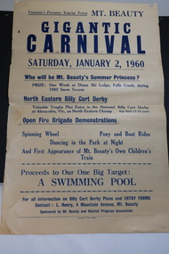 Kiewa Valley Historical Society
Poster - Mt Beauty Gigantic Carnival, 1960
... Yellowed paper with black print dated Saturday, January 2... with black print dated Saturday, January 2, 1960 advertising ...The residents of Mt Beauty and the Kiewa Valley swam in the local East and West Kiewa Rivers. The community began planning the building of a swimming pool at Mt Beauty in the early 1960s and held events to raise money for it. The building of a swimming pool in Mt Beauty is part of the construction town's development and demonstrates the support of the community, especially the Mt Beauty and District Progress Association, and the SECV.Yellowed paper with black print dated Saturday, January 2, 1960 advertising the events for the day at Mt Beauty. Proceeds to the Swimming Pool.mt beauty swimming pool, carnival, mt beauty and district progress association -
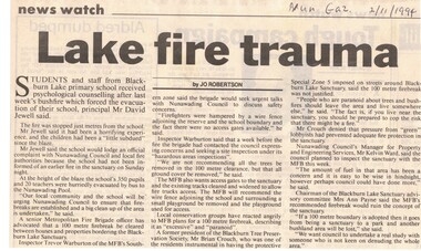 Whitehorse Historical Society Inc.
Article, Lake fire trauma, 2/11/1994 12:00:00 AM
... bushfires...bushfires ...2 November 1994 following the fire at Blackburn Lake . Melbourne Fire Brigade want access gates to the sanctuary and existing tracks cleared and widened to allow fire trucks access.Article in Nunawading Gazette 2 November 1994 following the fire at Blackburn Lake which burnt up to 100 metres of Blackburn Lake Primary School. Melbourne Fire Brigade want access gates to the sanctuary and existing tracks cleared and widened to allow fire trucks access. Also 150 metre fire break around the school was recommended but the chairman of the Blackburn Lake Advisory Committee thought having a fire break would ruin the concept of the sanctuary. 2 November 1994 following the fire at Blackburn Lake . Melbourne Fire Brigade want access gates to the sanctuary and existing tracks cleared and widened to allow fire trucks access. bushfires, blackburn lake primary school no 4860, jewell, david, city of nunawading, melbourne fire brigade, blackburn and district tree preservation society, blackburn lake sanctuary advisory committee, payne, ann -
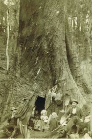 Bendigo Historical Society Inc.
Photograph - FAMILY LIVING IN LARGE TREE TRUNK
Sepia image (copy) picture shows family gathered at base of large tree trunk with door opening. Two small children in doorway, woman holding younger child inside tree, two men either side of image. Both men are wearing suit coats, vests and wearing hats. Straw broom and pots fixed to tree trunk. Man on RH side has an axe to his right. PLEASE NOTE: Letter with photo inquiring about the people in photo, states that the image is that of Peter Tyson, younger brother of James, his wife Margaret Sheil, and their twin daughters, Alice and Harriet. Diary is of accounts with limited text of a written diary on RH wide of sheets. Bookkeeper was Robert Primrose, whose name appears frequently in the book. Further research by Murray Poustie discovered that the photograph may actually be of Nicholas Penny, his wife Eva and their children Charlie, May, George and Nicholas. Also in the photograph on the left is their neighbour, Mr. John Green. The Photograph was taken by Max Lowenhardt when the Penny family was living in the tree at Fumina in 1906-07 following devastating bushfires. Fumina is in timber country at the foot of the Baw Baw Mountains and the area was frequently affected by major bushfires. The photograph was featured on the cover of the Gippsland Heritage Journal No.19, 1996 and is also extensively noted as ''The Penny family's tree home at Fumina'' in other publications including Vision & Realisation.person, receipts -
 Ringwood and District Historical Society
Photograph, Warrandyte Historical Society Newsletters nos. 76-84
Digitised WHS newsletters from December 1990 (no. 76) to October 1990 (no. 84). Sent to Secretary of the Ringwood Historical Research Group, Jack Lindsay.Noteable articles:- Earl Stewart bus service Brackenbury Street Yarra Yarra Mining Company Dr Owen's Puddling Machine 1927 bushfires Schult Steven Houghton Taffy Jones Great Southern Hill Caledonia Gold Mine Mary Hill - South Warrandyte Post Office Artists - Nutter Buzacott, Frank Crozier, Penleigh Boyd, William Frater, Christine Gray-Aldor Warrandyte Primary School Potter's Cottage -
 Otway Districts Historical Society
Photograph, Knox Collection, Sale of the Ditchley Park Estate, Beech Forest, 1908
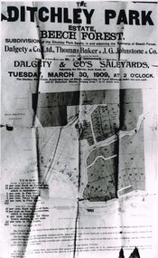
Commercial realities and bushfires caused the Beech Forest community to re-establish itself around the railway station, away from Gardner Hill. This caused John W. Gardner to subdivide his land on the north side of the railway station. One subdivision was created near the Ditchley railway station on the old racecourse site, and another of 25 allotments forming what became Southorn Street. There were very few takers for these lots nor any buyers for the Ditchley subdivision.Photocopy. 260mm x 159mm. An advertisement for the sale of the Ditchley Park Estate, Beech Forest. Under instructions from Mr. J.W. Gardner Dalgety & Co. Ltd. will sell the subdivision of the Ditchley Park Estate on Tuesday, March 30, 1909, at 2 o'clock. A map of Beech Forest township and the Ditchley Park Estate is attached, as are the terms of sale and a description of the area.. beech forest; ditchley park; land sale; advertisment; -
 Nillumbik Shire Council
Public Art: Edward GINGER (b.1951 Kegalle, Sri Lanka - arrived 1975 Aus), Edward Ginger, The Breeze, Location: Main Road, Research - opposite Eltham Little Theatre, 1990
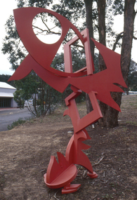
The first sculpture awarded the Shire of Eltham 'Art in Public Places' Award/Commission. The Judges were Inge King, Jenny Zimmer and Daryl Jackson. The work deals with the juxtaposition of suburban and rural surroundings. This scupture is a typical example of the artist's oevre of the period. This sculptre is site specific and refers to the nature of the environment. The colour - bushfire red / sienna - alludes to the history of fire in the urban/rural fringe and the title, as well as the sculpture's shapes, forms and material refer to the natural and local elements. Judges report noted: "The most vital and expressive work for the site...with a great sense of dynamic movement and vibrant colour. Its' abstract forms will enliven the surroundings and the urban and natural environment. This work is the most appropriate for the site and expressive of the dynamics of an evolving community in which artistic discourse and debate has always thrived." The work has acquired the status of a major landmark from the National Trust. The Breeze is an abstract work made out of welded steel and painted in enamel in bush fire red / sienna. It comprises a series of flat, cut-out shapes, interlocking at different angles, giving the impression of being hinged together rather than fixed. The work references nature and the built environment. Its geometric shapes suggest man-made structures within industry and suburban life, while rural areas can be identified by the organic flame-like shapes fanned by the wind. The circular cut-out in the eye mimics the sun, symbolising the intense heat of the Australian climate, while the colour red alludes to the history of bushfire within the urban and rural fringe. N/Apublic art, ginger, red, sienna, elements, steel, abstract, breeze, fire, sculpture -
 Forests Commission Retired Personnel Association (FCRPA)
Rakut - Fire rake, Unknown FCV District, c 1952
Bushfire perimeter rather than bushfire area is the main control problem for firefighters on the ground. A conundrum rapidly compounded by spot fires. A small 5 ha fire can be nearly 1 km around the perimeter. That's a long way to build a control line by hand in rough bush. Dry firefighting techniques by hand were mostly confined to “knocking down” or “beating out” the flames, as well as "digging out". Digging or raking a “mineral earth” trail down to bare dirt proved most effective in forest fuels which, unlike grass, tend to retain heat and smoulder. Early tools were whatever happened to be close at hand. They were simple and primitive and included shovels, slashers, axes, hoes, beaters and rakes. A cut branch to beat the flames was often the only thing available. Farming and logging tools, developed over centuries of manual labour, and readily available at local hardware stores came into use, but little thought was given to size, weight, and balance. For years foresters experimented with combination tools. In about 1952 fire beaters and other implements were being replaced with Rakuts.Fire tool used before the introduction of RakehoesRakut - Fire Rake and cutting toolGreen and red coloured handle and 020 marking indicated which FCV District the tool belonged tobushfire -
 Eltham District Historical Society Inc
Photograph, Barry Philp, Second Hand store at the southeast corner of Reynolds Road and Main Road, Eltham, c.1969
... bushfires...bushfires ...Corner of Reynolds Road. The store is on the left, the house on the right was the home of the Dodkins family (Phographer Barry Philp's uncle and aunty). The house on the hill was Philbrick's home which burnt out in the bush fires.bushfires, dodkins family home, fire damage - buildings, main road, philbrick family home, research (vic.), reynolds road, second hand dealer, victorian bushfires - 1969, eltham, eltham-yarra glen road -
 Kiewa Valley Historical Society
Roper's Hut Memorabilia
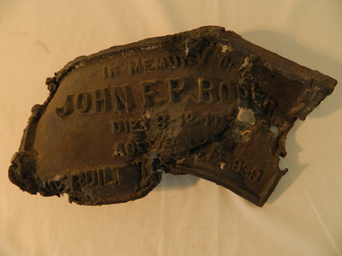
Roper's Hut was built in 1939 and was burnt down in 2003. It was rebuilt in 2008 and is situated on the Bogong High Plains on Duane Spur (where Duane's hut had been before it too was destroyed by (1939) bushfires, between Mt Nelse and Big River. The original hut was used as a shelter for cattlemen who grazed their cattle on the High Plains during summer. The Victorian High Country Huts Association Inc. members and friends helped rebuild the hut which is now used as an emergency shelter for visitors to the High Plains.The memorabilia is significant as the items belonged to the Roper family who were one of the original settlers of the Kiewa Valley and one of the original families who drove their cattle up to the Bogong High Plains. The burnt plaque and forks and the rebuilding of the huts (Duane's & Roper's) are significant as bush fires are a constant threat to the Bogong High Plains destroying large areas at a time.1. Bronze Plaque and 2 damaged forks from Roper's Hut which was destroyed by bush fires in 2003. 2. DVD & USB and hard copy photos of the rebuild of Roper's Hut in January 2008.The plaque had 'In Memory of / John F. P. Roper/ died 3-12-1977 / Aged 78 years / He built the original hut Feb. 1939'roper's hut, cattlemen, bogong high plains, bronze plaque, roper family, bush fires -
 Kiewa Valley Historical Society
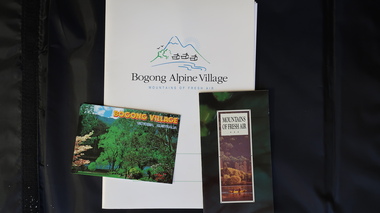
Papers - Bogong Village & the 'Commissioner's' Lodge & Progress Association Members, c 1997/1998
Bogong Village was built by the SECV in 1940 for the workers of the Kiewa Hydro Electric Scheme. In 1971, 30 houses were furnished for use as holiday homes for SEC personnel throughout the State. From 1989 to 1993 the houses were restored & renovated.During the 1990s the buildings in the village had been leased to private owners. Many of them rented their houses for tourists. The Commissioner's lodge was on the other side of the Mt Beauty - Falls Creek road, above Bogong Village. Wally Baldwin ran it in the 1960's.It was destroyed by the 2003 bushfires.These papers present a history of 'the Commissioner's lodge' and Bogong Village in the 1990's. The Progress Association was an active community group in 1963/64.Papers advertising Bogong Village & the Lodge for accommodation with rates 1997/1998. Describes the alternatives, maps and cafe hours, Also, 'Jan's Recollections' and on the back of these pages a hand written list of members of the the Progress Association 1963-64 as 'per Mr A. McCullough's spiel'. In original folder and includes a pamphlet & postcard.bogong village, secv lodge, lake guy, state electricity commission of victoria., kiewa hydro electric scheme, tourism, accommodation -
 Ringwood and District Historical Society
Document - Department of Lands and Survey, Wire Netting Branch, Melbourne, Victoria, Application for Vermin-Proof Fence Certificate - L.J. Mills vs John Collins, Grandview Grove, Ringwood, Victoria - 1939
Photocopied file of corresponence and documentation relating to a claim by L.J. Mills, Nurseryman, that adjoining property owner, J. Collins, Farmer, assists with replacement of a vermin proof wire netting dividing fence destroyed by 1939 bushfire. File includes 1939 and 1940 detailed property inspection reports by Vermin and Noxious Weeds Branch, Lands Department, Lilydale, describing land use in the area and signs of vermin activity. Application approved 18th April, 1940. Appeal lodged by Mr Collins disallowed in May, 1940. File closed June, 1940 with Departmental suggesion that Mr Mills consider further legal action through a Solicitor as fence had still not been wire-netted. TRANSCRIPTS: Vermin & Noxious Weeds Inspection Reports "19/9/1939 (To) Superintendent (Department of Lands and Survey, Melbourne) Re L.J. Mills application for Vermin Proof Fence. I called on Mr Mills yesterday 18th instant in connection with this matter. Mr Mills has a flower farm and claims that rabbits and hares are damaging his flowers. He showed me a bed of carnations which he stated were being damaged by rabbits. There was evidence of some leaves being nipped off, but I am unable to say whether this is due to rabbits or grubs. Very little if any real damage is being done. The property is netted on the east and south boundary and on half the north and west boundary. The surrounding country is undlating and fairly steep in places. The land to the east across Grandview Avenue (sic) is all planted out in old established orchards and well cultivated. Cleared grass land adjoins the south boundary and bush land adjoins the north and west boundaries. I walked over a large area surrounding Mr Mills land and never saw any rabbits or hares or any indications of rabbits. This locality is not rabbit infested and very little wire netting is being used. I do not consider that a vermin proof fence is necessary between these allotments. - Jas H Allison (Inspector, Vermin and Noxious Weeds Branch, Lands Department, Lilydale)." Follow up report following renewal of application for Certificate by Mr Mills, citing rabbits causing considerable damage to his flowers. He laid poison and obtained 9 carcases and stated that there is evidence of rabbit infestation from the adjoing land. "19/3/1940 (To) Mr Hannah (Superintendant, Department of Lands and Survey, Melbourne) Re L.J. Mills, Grandview Grove Ringwood, Lot 4 Grandview Estate Pt CG20 Ph of Warrandyte. I interviewed Mr Mills at his home on 15th inst. He showed me carcases of rabbits which he stated had been poisoned on his land. In places young plants had been nipped off apparently by rabbits. I made an inspection of adjoining properties and found one live burrow close to Mr Mills northern boundary. There were scratches and other evidence of rabbits on land north and west of Mr Mills property. In view of the present evidence of rabbits I consider that a vermin proof fence is now necessary to protect the flowers grown by Mr Mills. His land is netted on whole of east and south boundary and half way on west and north boundary. The adjoining land on west and north boundaries is owned by Mrs Linda Collins and John Collins resp of Brysons Road East Ringwood. - Jas H Allison (Inspector, Vermin and Noxious Weeds Branch, Lands Department, Lilydale)." -
 Eltham District Historical Society Inc
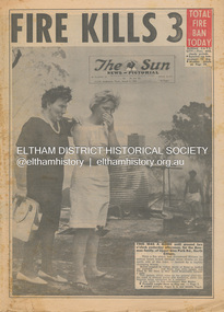
Newspaper - Newspaper articles, Sun News-Pictorial, Fire Kills 3, The Sun News-Pictorial, Thursday, March 4, p1, 1965
... Victorian Bushfires - 1965 ...Various news articles pertaining to the January 1965 Victorian bushfires specifically with a focus on fires at Eltham North. Specific Eltham Shire districts mentioned include Eltham North on page 1, 2, 3, 28-29 • Fire Kills 3, p1 (Illust.) • Fire on their heel, p2 (Illust.) • Flames catch, kill 3 as they run: 12 house go, p3 (Illust.) • It doubled back, p3 • Helpers highly praised, p3 • Blaze kills 100 puppies, p3 (Illust.) • Scenes from Eltham’s Black Wednesday, pp28-29 (Illust.) tom fielding collection, victorian bushfires - 1965, victorian bushfires – 1965, glen park road, eltham north, sunny pine, bushfire damage – buildings, back gully, gippsland, glenmaggie, briagolong, george john crowe, john lawrence coleman, william john elwers, creek road, wattle glen, bill guy -
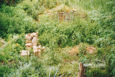 Eltham District Historical Society Inc
Photograph, Ruins of Coulstocks Mill, Janefield, South Morang
Mill Park Farm at Janefield on the Plenty River was established around 1840 by George Coulstock where he grew wheat. His flour mill was one of the first in Victoria, under construction as early as 1841. After bushfires and Coulstock's early death in 1842, the farm and its mill were taken over by local landowners Henry Miller and John Brock. Peter Hurlestone took charge of the mill. With water diverted from the Plenty River to fill the newly built Yan Yean Reservoir which opened in 1857, the Hurlestone family quit and that was the demise of the mill.Four colour photographs showing the ruins of Coulstocks Flour Mill (Janefield Mill), Janefield. 1. Stone wall 2. Old mill 3. Stone remains of old mill 4. Tree near old mill sitemills, flour mills, coulstock, janefield, plenty river, ruins, stone walls, plenty gorge, bundoora