Showing 1695 items
matching grover
-
 City of Kingston
Photograph - Colour, 6 March 1993
Edithvale is a suburb in the City of Kingston. It is located between Aspendale and Chelsea on the Port Phillip Bay and built within remnant areas of the Carrum Carrum swamp. The foreshore precinct comprises a wide sandy beach, with low sand dunes and numerous historic boat sheds. The suburb consists of older style dwellings and former holiday houses, combined with mid-century housing and newer homes. The large blocks are increasingly subdivided and the existing dwellings demolished to accommodate units and townhouses, thus changing the landscape of the area and reducing the tree canopy.The beachside suburb of Edithvale was previously part of the extensive Carrum Carrum Swamp. The area was once a source of fish and eels for the Mayone-Bulluk clan of the Bunurong people. Over time the area was drained and predominantly devoted to dairy farming and holiday houses. The farms were gradually sold and subdivided with a large number of homes built after World War II and in the 1960s. Edithvale is mainly residential with a shopping strip along Nepean Highway but little significant industry was ever established in the area apart from a plaster works and confectionary factory, both now closed.Laminated aerial colour photograph of Edithvale as viewed from Alexandra Avenue in the north to Ella Grove Chelsea/Edithvale in the south. regents Park Aspendale can be seen in the top left. The area is built-up with residential housing and facilities including Edithvale Primary School, numerous churches and the Edithvale Railway station. Large sections depict the remnant Carrum Carrum swamp. Edithvale Common and the former "Duck Inn" (Melbourne Water/Friends of Edithvale Seaford Wetlands) can be seen. Edithvale Recreational reserve, the valodrome and Edithvale Public Golf Course are prominent. The image shows vacant land in the area now known as Aspendale Gardens and the newer residential section of Chelsea Heights is not developed. A bike path has been established to cover the secondary drain. The Golf Links Court residential development located off Hughes Avenue is a large vacant block.Black type on white adhesive label: 6-3-93 Black type on white adhesive label: 25/9211, 6/3/93, 11.20 am Black type on white adhesive label: 9211 Yellow circular adhesive sticker Black pencil: 9211 6-3-93 arrow pointing Nedthvale, carrum carrum swamp, aspendale, chelsea -
 Melbourne Tram Museum
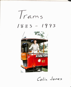
Album - Photo Album, Colin Jones, "Trams 1883 - 1993", 1990's
Photo Album, grey decorative front cover with a grey heavy card slip case, 30 leaves of heavy paper, each separated by a semi clear protective sheet. Compiled by Colin Jones with a title sheet "Trams 1883 - 1993" with Colin standing in the front of Brisbane Tramway Co. No. 47 at the Ferny Grove Museum. Bound with end papers. Photos retained by clear photo corners. Features photos by Colin of: Victor Harbor Surabaya Indonesia Melbourne cable trams, Sydney Steam tram in the UK Ballarat Bangkok Semarang Indonesia Adelaide Brisbane Melbourne Sydney Bendigo Launceston Osaka Japan Perth Kyoto Dalian Japan Fukuoka Japan Kanazawa Japan Hong Kong Sendai Kita Kyushu Hobart Lopburi Kobe Hiroshima Tokyo Matsuyama Japan Nagaski Various Museums in Australia. Sample pages only scanned.trams, tramways, melbourne, album, japan, indonesia, australian tramways -
 Ringwood and District Historical Society
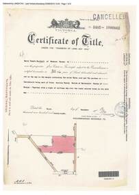
Document, Certificate of Title - Harry Temple Marshall, Wesburn Farmer, Vic. - part of Crown Section 20, Parish of Warrandyte, County of Evelyn - 1928
A4 copies of Landata Victoria Historical Search documents - Vol 5485 Fol 1096803. Harry Temple Marshall is now the proprietor of an Estate in Fee-simple subject to the Encumbrances notified hereunder ... 10 acres 3 roods 10 perches or thereabouts, together with a right of carriage way over roads coloured brown. Subdivision map includes un-named roads - western side is Wonga Road (later Warranwood Road), and eastern side is Grandview Grove (later Bemboka Road), both north of Plymouth Road, Ringwood, Vic. Transfers include Harold Claude Howship, 1st December, 1928 James Bell McAlpin, 26th March, 1939. -
 Eltham District Historical Society Inc
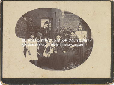
Photograph - Cabinet Photograph, William Ingram family, Birmingham, England, c.1880
William Ingram with possibly his wife Pamela Thomas and family members. William is second from left with pipe, the others unidentified. The family lived in Birmgham, England. William, a baker died in 1905. William and Pamela had six children; William George Grove (1861-1939), Elizabeth (1865), Evan Thomas (1867-1956), Joseph (1868-1934), Louis (1870-1941) and John (1872-1958). John Ingram learnt his trade from his father but following a quarrel with his father, he ran away and worked his passage to Australia as a ships baker. His elder brother Evan was already in Australia living in Malvern. It was here that he met Ada Key. John and Ada were married in Fremantle, Western Australia. They travelled to England then Cape Town, a family already started. They returned to Melbourne and in 1901 bought land at Research where he worked to establish an orchard and worked at night asa baker in Eltham. The fashion and hairstyles appear trypical of around 1880ingram family, birmingham, william ingram, baker, pam thoonen (nee ingram) collection -
 Eltham District Historical Society Inc
Document - Property Binder, 816 Main Road, Eltham
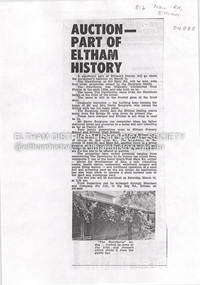
Newspaper article: Auction part of Eltham History, Diamond Valley News, 11 March 1980, auction on 15 March of The Hawthorns and other properties by the Burgoyne family. On same page another article :"The unusual on a hill" about Robert Marshall, Shire Councillor and architect's own home. On reverse side real estate advertising including several Woodridge Estate properties. Newspaper article: Centre becomes a second home, Diamond Valley News, Tuesday, September 23, 1986, p3 about new child minding centre. On same page "residents carry on fight for road works" about planned road works in Kirwana Grove, Montmorency and "Advice bureau needs volunteers" about Eltham Citizens Advice Bureau. On reverse side (page 4) advertising for Kentons Shoes closing down sale at Shop 3 Eltham Mall, Arthur Street and article "Nursing mums donate books" featuring Eltham Branch of Nursing Mothers Association (with photo).main road, eltham, property, the hawthorns house, burgoyne family, harry burgoyne, hawthorn hedges, 816 main road eltham, advertising, avril benson, child minding centre, eltham citizens advice bureau, eltham high school, eltham rsl sub-branch, eltham shire council, john stevens, kaye mount, kirwana grove, main road child minding centre, montmorency, montmorency primary school, roadworks, rob stanley, ruth kirkpatrick, angela hennel, arthur street mall, banner project, diamond valley childbirth education association, kentons shoes, nursing mothers association, sue gavan, woodridge estate, mudbrick, robert marshall, st andrews -
 Bendigo Military Museum
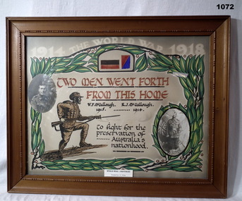
Certificate - CERTIFICATE, FRAMED, Post 1920
Reginald Joseph McCULLOUGH No 2203 enlisted in the AIF in 15th reinforcements 3rd LHRegt on 15.11.1915 age 28 years 7 months. Embarked for Egypt 16.3.1916, transfers to Artillery Details 15.5.1916, embark for England 28.6.1916, attached to 5th Div Artillery, embark for France 4.9.1916, transfer to 14th FAB 11.10.1917, WIA 2.11.1917, SW to right leg fracture, rejoin unit 19.7.1918, hospital 25.10.1918 with Cellulitis left knee then classified as Synovitis, transfer to AHQ 9.12.1918, hospital 20.12.1919, died Grove Military hospital England classed as Excema and Syncope 30.12.1919. William Francis McCULLOUGH No 2863 enlisted in the AIF in 6th reinforcements 24th Battalion on 12.7.1915 age 21 years. Embark for Egypt 27.10.1915, transfer to 7th Bn 24.2.1916, embark for France 26.3.1916, hospital 18.6.1916 Dental, rejoin unit 25.6.1916, hospital 4.11.1916 with Diarrehoea, rejoin unit 9.11.1916, hospital 22.4.1917 (unclear) rejoin unit 13.5.1917, transfer to 1st Aust Div Signals, discharged from the AIF 28.7.1919.WWI Brothers - W F McCullough & R J McCullough. Frame, tan wooden, glass front, cardboard backing. Certificate, painted, coloured with a photo of each brother inserted.On certificate: TWO MEN WENT FORTH FROM THIS HOME W F McCullough 1915 R J McCullough 1914 On sticker at bottom of glass: WORLD WAR I BROTHERS Donated by J E Wilesdocuments - certificates, frame accessories -
 Old Colonists' Association of Ballarat Inc.
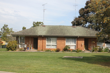
Image, Ballarat Old Colonists' Association Retirement Village - Joe White Homes, 23/09/2017
These homes were built in 1969. One of the first objectives of the Association was "to provide the shelter of a those for those Pioneers of the Goldfields whom the reverses of fortune have deprived of the means of procuring the comforts of life in their declining years." The first home at Charles Anderson Grove was built in 1925. Before that time the Association provided relief for needy pioneers. relief included monthly monetary payments, loads of firewood, medical assistance and distribution of Christmas bosed of groceries to deserving pensioners, and in some cases payment of burial costs. ::a) The dominant purpose of the Association is to give public benevolent relief as a charity, but providing independent living accommodation in our Retirement Village for person in need who are over 65. ::b) To raise funds by membership subscription, commercial and residential rents, donations, gifts and voluntary work, for the purpose of providing direct relief of poverty, distress, misfortune or helplessness. ::c) To maintain the important heritage and ongoing viability of the Old Colonists' Association. (Revised Rules of the Old Colonists' Association of Ballarat Inc., 2016) The Joe White Cottage in the Ballarat Old Colonists' Association Retirement Village.old colonists' association, ballarat, ballarat old colonists' club, joe white, charles anderson grove, joe white cottage -
 Old Colonists' Association of Ballarat Inc.
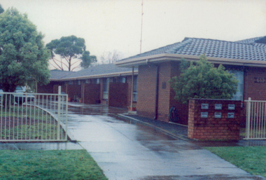
Image, Ballarat Old Colonists' Association Residence - Unit 1-6 Ascot Street, Ballarat, c2000
These units were built in 1991. One of the first objectives of the Association was "to provide the shelter of a hose for those Pioneers of the Goldfields whom the reverses of fortune have deprived of the means of procuring the comforts of life in their declining years." The first home at Charles Anderson Grove was built in 1925. Before that time the Association provided relief for needy pioneers. relief included monthly monetary payments, loads of firewood, medical assistance and distribution of Christmas bosed of groceries to deserving pensioners, and in some cases payment of burial costs. ::a) The dominant purpose of the Association is to give public benevolent relief as a charity, but providing independent living accommodation in our Retirement Village for person in need who are over 65. ::b) To raise funds by membership subscription, commercial and residential rents, donations, gifts and voluntary work, for the purpose of providing direct relief of poverty, distress, misfortune or helplessness. ::c) To maintain the important heritage and ongoing viability of the Old Colonists' Association. (Revised Rules of the Old Colonists' Association of Ballarat Inc., 2016) Colour photograph of the former Old Colonists' Association of Ballarat Inc homes in Ascot Street, Ballarat.ballarat old colonists' association, homes, ascot street units -
 Kew Historical Society Inc
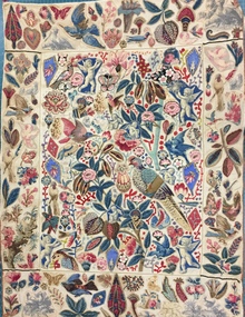
Decorative object - Cotton chintz applique on linen wall hanging [Broderie Perse], 19th Century
This broderie perse' wall hanging was donated to the Kew Historical Society in 1980 by Mrs Joy Ivory. The hanging had belonged to her mother - Amy Grigg - and was used by the latter to demonstrate skills in darning (the red stitching). Provenance includes a certificate dating from 1889 which records an award to Amy Grigg of Pakington Street (Kew) for skills in needlework, issued by the Kew Floral Industrial & Art Society. Amy Grigg later married Albert Watson, the son of John Watson. The latter was an early pastor of the Kew Methodist Church in Highbury Grove, Kew. Both the Watson and Grigg families were early pioneers of Kew. While the hanging was modified by Amy Grigg in 1889, the original textile dates from an earlier period when 'Broderie Perse' (Persian embroidery) was used to create quilts and wall hangings. It is estimated that the hanging dates from the first half of the 19th century. An exact dating will require a detailed examination of the cotton chintz fabrics used to embroider the hanging. This appliquéd wall hanging is one of the earliest textiles in the Kew Historical Society's fashion & textiles collection. Similar examples are held in major international collections such as the Victoria & Albert Museum. This example of broderie perse is significant for the cross-cultural influence of Indian textiles on European taste, not unusual given the English foothold in India during this period. Additional interest is due to the mixing of Indian and European textiles in the design, while staying true to the derivation of the design. The textile is both well-provenanced and rare. While it is unlikely to be Australian-made, it is probably an example of a textile brought to Australia during the colonial period that indicates a desire to decorate interiors using items created in and for the English home. On another level, the wall hanging is a fine example of 'women's work' in the first half of the nineteenth century.Small wall hanging, comprised of five panels that are each appliquéd by hand in herringbone stitch using a range of decorative figurative motifs including flora and fauna. The design is based on an Indian palimpore representing a tree of life design. The base textile is a cream linen while the appliquéd figures or shapes are cut from cotton chintz. These additions are probably a mix of Indian and European designs. The quality of the herringbone stitching is very fine. Later stitching in red wool was added in the 1890s to demonstrate skill in darning. The main panel is bordered by a narrow green and ecru braid. It has a narrow tan braid at the top and bottom of the two side panels. A surrounding tan braid around the entire textile is missing in some places. textiles, applique, broderie perse, amy grigg, wall hangings, migration -
 Kew Historical Society Inc
Album - Scrapbook, Eva Grant, Historic Buildings, Kew, 1958-78, 1970s
One of three scrapbooks of photographs and newspaper cuttings taken and or collected by Eva Grant, a past member of the Kew Historical Society, which were donated by her niece, Julie Thomson. The albums include many photographs of Kew from the 1950s to the 1970s. Buildings included in the scrapbook include: Billy Hughes' house - 167 Cotham Road Congregational Church - Walpole Street (c.1978) Country Roads Board - Denmark Street (1960) Dorothy Rogers Reserve - Studley Park Road Ellsmere (also Ellesmere/Ellsmore) - Princess Street Field Place - 3 Henty Court Fernhurst - 13 Fernhurst Grove Kew Civic Centre (1959) Kew Junction (1958) Kew Railway Station (1902, 1959) Kew Recreation Hall - Wellington Street (1960) Neama (Hall) - Studley Park Road Southesk (formerly Ordsall) - Cotham Road (c.1960) St Anthony's Home for Babies (formerly Madford) - 43 Wellington Street (c.1976) Studley House - Nolan AvenueThe scrapbook contains historically significant, rare and sometimes unique images of significant heritage buildings in Kew, including their erection and demolition. 11-page scrapbook of photographs and newspaper clippings with annotations by Eva Grant, a past member of the Kew Historical Society. The pages of the album can be viewed in the image carousel above. Based on the text and known dates of demolition of a number of the buildings, the scrapbook was assembled over a twenty year period between c.1958-c.1978.Includes letter from donoreva grant, billy hughes' house - 167 cotham road, congregational church - walpole street - kew, country roads board - denmark street - kew, dorothy rogers reserve - studley park road - kew, field place - 3 henty court - kew (vic), ellsmere (also ellesmere/ellsmore) - princess street - kew, fernhurst - 13 fernhurst grove - kew (vic), kew civic centre - civic drive - kew (vic), kew junction - kew (vic), kew railway station - denmark street - kew (vic), recreation hall - wellington street - kew, neama - hall - studley park road - kew (vic), southesk - ordsall - cotham road- kew (vic), st anthony's home for babies - madford - 43 wellington street (vic), studley house - nolan avenue - kew (vic) -
 Kew Historical Society Inc
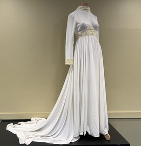
Clothing - Wedding dress, The House of Franke, Stuart, c.1975
At 5pm on 2 May 1975 at Christ Church, Hawthorn, the wedding took place between Kathryn Gwynn Marx of Mason Street, Hawthorn, and William Peter Reeve of Mountain Grove, Kew. The bride's dress was purchased from the 'House of Franke, Stuart', 612 Glenferrie Road, Hawthorn, a very popular place in the 1970s for brides. Kathryn was educated at Ruyton Girls' School with Margaret Franke so it was a nice connection. Margaret's family business had been in operation since 1926. I loved my wedding dress. It was soft and comfortable to wear and kept me warm on the May evening. It was elegant and I knew I would never get the chance to wear something with a long train again. Walking down the staircase at the Windsor Hotel in Melbourne felt very grand; a memory I still hold today. (Kate Reeve, 2022) [Note: Two photos and a newspaper article which are viewable in the image carousel are held in the donation file]Strong local provenance to Hawthorn, Kew and Boroondara due to owner and retailer. It is a representative example of wedding dresses sold in the 1970s. The wedding dress is made of fine soft white jersey with guipure lace around the neckline, wrists and bodice. The long train has three small discreet loops along the hemline which can be slipped onto a finger for a draped effect giving ease of movement for dancing etc. A satin trimmed veil covered the length of the train and was secured on the head with a satin coronet. White leather shoes were worn. The bouquet Phalaenopsis orchids. (Note: the veil and shoes were not part of the donation)Label: Franke Stuart / Hawthornfashion & design - 1970s, wedding dresses, kate reeve, peter reeve, franke stuart, retailers - glenferrie road - hawthorn (vic.) -
 Kew Historical Society Inc
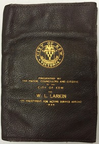
Functional object - Presentation Wallet, City of Kew, 1939, 1939
William 'Bill' Leo Larkin (b. 19.09.1898) was born in Hawthorn (Vic). [His World War I enlistment papers give details of the Hawthorn birthdate, as well as Ballarat, but his birth records state his birth as Hawthorn). After leaving St Patrick's College in Ballarat in 1917, he enlisted in the army serving in England and France. At the time of his enlistment in the army in the Second World War (17 April 1940), he was recorded as living in Kew. His service number was VX11459. The Sands & McDougall Directory of 1938 gives his address as 31 Fernhurst Grove. In the army he served in the Middle East and in New Guinea. He was to attain the rank of Lieutenant Colonel in 1942. He was made an Officer of the Order of the British Empire (O.B.E) in 1946. Enlistment Presentation Wallets were presented by the City of Kew from 1940 to men who enlisted in the war. Typically, these wallets are dated 1939, even though the enlistment may have occurred at a later date.Memento presented to citizens of Kew (vic.) on enlistmentRectangular brown leather single fold wallet with eight internal pockets. The front includes an embossed City of Kew logo and the words ‘Presented by the Mayor, Councillors and Citizens of the City of Kew to W. L. Larkin on Enlistment for Active Service Abroad, 1939'.second world war 1939-1945, world war two, city of kew, william leo larkin, bill larkin, presentation wallets -
 Kew Historical Society Inc
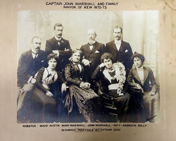
Photograph - Family Portrait, Captain John Marshall and Family, Mayor of Kew 1872-73, 1890s
Captain John Marshall was born in Dundee, Scotland c.1833. Within eleven years of his arrival in Melbourne in 1852, he had established an important colonial shipping company, Anderson & Marshall, and married Mary Austin, the eldest daughter of Thomas Austin Esq of Clifton Villa in Cotham Road. Elected to the Kew Borough Council in 1869, he remained an active member until 1875. During this period, he was elected Mayor of Kew in 1872. A Scottish Protestant by birth and conviction, John Marshall was, with David Beath, a member of the inaugural committee that began planning for a separate Presbyterian Church in Kew, lending the Committee the funds to purchase land on the corner of Cotham Road and Highbury Grove. John Marshall lived at his home, 'Maryfield', at what was then 239 [now 197] Cotham Road until shortly before his death at the age of 70 in January 1903. He was buried on 14 January in Grave 493, Presbyterian Compartment A, Boroondara General Cemetery.Family portrait of an important civic figure in Kew in the 19th century who was also a notable businessman and shipowner in the Colony of Victoria.Albumen Silver photograph on card of Captain John Marshall and family, Mayor of Kew 1872-73.The inscription was added by the family and at one stage modified. In addition to the title, the sitters' names are inscribed beneath the photograph on the mountCaptain John Marshall and family / Mayor of Kew 1872-73 Webster - Maud - Austin - Mary Marshall - John Marshall - May - Andrew - Polly / Residence “Maryvale” 197 Cotham Road. john marshall, maryvale (cotham road, kew), maryfield (cotham road, kew), webster marshall, maud marshall, austin marshall, mary marshall, may marshall, andrew marshall, polly marshall -
 Kew Historical Society Inc
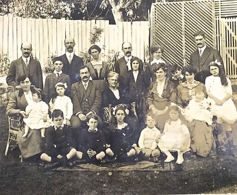
Photograph - Family portrait, The Marshall Family, 1903-1914
Captain John Marshall was born in Dundee, Scotland c.1833. Within eleven years of his arrival in Melbourne in 1852, he had established an important colonial shipping company, Anderson & Marshall, and married Mary Austin, the eldest daughter of Thomas Austin Esq of Clifton Villa in Cotham Road. Elected to the Kew Borough Council in 1869, he remained an active member until 1875. During this period, he was elected Mayor of Kew in 1872. A Scottish Protestant by birth and conviction, John Marshall was, with David Beath, a member of the inaugural committee that began planning for a separate Presbyterian Church in Kew, lending the Committee the funds to purchase land on the corner of Cotham Road and Highbury Grove. John Marshall lived at his home, 'Maryfield', at what was then 239 [now 197] Cotham Road until shortly before his death at the age of 70 in January 1903. He was buried on 14 January in Grave 493, Presbyterian Compartment A, Boroondara General Cemetery.Family portrait of the relatives of an important civic figure in Kew in the 19th century who was also a notable businessman and shipowner in the Colony of Victoria.Albumen silver photograph on card of the Marshall family grouped in three rows in a garden setting. The twenty-three members of the extended family do not include John Marshall so the photograph presumably dates from after his death in 1903. His wife, Mary Marshall, is in the middle row, five from left. marshall family, john marshall -- mayor of kew -
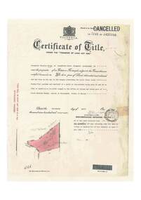
 Ringwood and District Historical Society
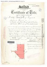
Document, Certificate of Title - Mary Burchett, Lilydale Road, Ringwood - part of Crown Section 20, Parish of Warrandyte, County of Evelyn - 5th July, 1911
A4 copies of Landata Victoria Historical Search documents - Vol 3520 Fol 703990.Mary Burchett of Ringwood, Married Woman, is now the proprietor of an Estate in Fee-simple subject to the Encumbrances notified hereunder ... 50 acres 1 rood 32 perches or thereabouts, being lots 1 and 10 on plan of subdivision no.4315. Subdivision map includes un-named roads - western side is Wonga Road (later Warranwood Road), and eastern side is Grandview Grove (later Bemboka Road), both north of Plymouth Road, Ringwood, Vic. Title transferred to Theodore Hartley Burchett, 27th July, 1911. Encumbrance comment "Special railway condition contained in Grant to Francis Cooke." -
 Ballarat Tramway Museum
Administrative record - Log book, Diary, Sands McDougall Pty Ltd, 1951
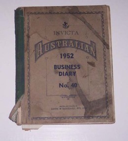
Yields information about the track maintenance activities of the track gang in Ballarat, the work they did, notes, names and other information.Invicta Australian 1952 Business Diary, No. 40, printed by Sands and McDougall, green Rexene binding, card covers, sewn sections with ruled sheets providing a diary for 1952, 2 days and notes for each page. Has "useful information" sheets at from the diary. Used by the SEC Ballarat track gang to record their daily work, leave, welding, track cleaning, truck driver etc Rear pages - has a detail list of locations, depth of grove for both rails, rail type and type of rail, whether old or new. Loose contents 1 - 1/7/1952 page - SEC memo written on two sheets, dated 4/5/1949 regarding track work and a SEC Ballarat envelope with notes on the sheet. 2 - 3/9/1952- notes on a daily time sheet 3 - 14/11/1952 - sheet of lined paper with notes.tram, trams, sec, ballarat, depot, trackwork, rails -
 Bendigo Historical Society Inc.
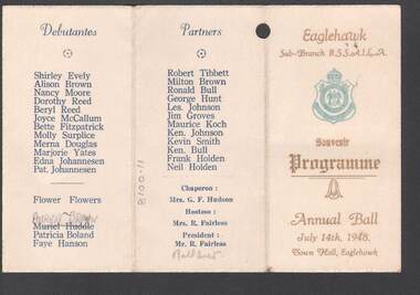
Document - R.S.L. BENDIGO COLLECTION: SOUVENIR PROGRAMME EAGLEHAWK RSL ANNUAL BALL 1948, 14th July, 1948
Eaglehawk Sub-branch R.S.S.A.I.L.A. Annual Ball, July 14th, 1948 held at the Town Hall, Eaglehawk. Card is cream with gold printing on the front and a blue RSL badge. On the inside the trifold card has a Dance Program of 21 named dances and a space for Autographs. On the back left are the names of the Debutantes and Flowers. They are: Shirley Evely, Alison Brown, Nancy Moore, Dorothy Reed, Beryl Reed, Joyce McCallum, Bette Fitzpatrick, Molly Surplice, Merna Douglas, Marjorie Yates, Edna Johannesen, Pat Johannesen, Patricia Brown, Patricia Boland and Faye Hanson. On the next fold are the Partners: Robert Tibbett, Milton Brown, Ronald Bull, George Hunt, Les. Johnson, Jim Groves, Maurice Koch, Ken. Johnson, Kevin Smith, Ken. Bull, Frank Holden and Neil Holden. Chaperon: Mrs G F Hudson. Hostess: Mrs R Fairless and President: Mr R Fairless.event, social, annual ball, r.s.l. bendigo collection - souvenir programme eaglehawk rsl annual ball 1948, shirley evely, alison brown, nancy moore, dorothy reed, beryl reed, joyce mccallum, bette fitzpatrick, molly surplice, merna douglas, marjorie yates, edna johannesen, pat. johannesen, patrica brown, patrica boland, faye hanson, robert tibbett, milton brown, ronald bull, george hunt, les. johnson, jim groves, maurice koch, ken. johnson, kevin smith, ken. bull, frank holden, neil holden, mrs g f hudson, mrs r fairless, mr r fairless -
 Ringwood and District Historical Society
Document - Folder, Land Sale - Monterey Park Subdivision, Warrandyte Road, Ringwood North, Vic. - 1981
Foolscap manilla folder containing double-sided flyer advertising residential subdivision development, including outline of local facilities and services, with locality map and layout of Monterey Park streets. Subdivision includes Parkwood High School, Tortice Drive, Heape Way, Appleberry Place, Stringybark Court, Conifer Court, Crawley Grove, Monterey Close (later Monterey Place), Lucy Place, Middlebrook Drive, Gahnia Close, Glanfield Court, Cone Close, Jull Parade, Pinus Close (later Pinetree Court), Radiata Close, Old Warrandyte Road, and entry from Warrandyte Road. Vendor - Jennings Industries Limited, 690 Springvale Road, Mulgrave, 3170, Phone 5618000. A4 enclosures with tables showing each allotment List Price, Builders Price, Cash Price and Terms Price. Information page headed "Form of Restrictive Covenant to be incorporated in Transfer" specific to Certificates of Title. Restrictive Covenant (summary): (Name/s) "... will not erect or construct or cause to be erected or constructed on the land hereby transferred (a) Any front boundary fence, other than a fence which does not exceed one metre in height unless the same is set back as least 1.5 metres from the front boundary and the same is effectively screened from that boundary by the planting of trees, shrubs or plants. (b) Any side boundary fence other than a fence which is set back at least 1.5 metres from the front boundary on which does not exceed 1 metre in height within 1.5 metres of the front boundary. (c) For a period of 5 years from the date hereof, any building on the said land unless and until the Plans and Specifications thereof have first been approved by the said Residential Developments Pty. Limited. (d) For a period of 2 years from the date hereof whilst the said land remains vacant any Signboard or Notice advertising the sale of the said lot or any other lot. These covenants shall appear on the Certificate of Title to issue for the said land and run with the land." -
 Melbourne Tram Museum
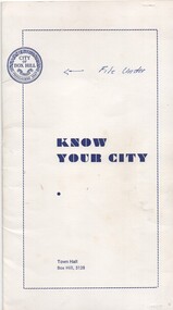
Pamphlet, City of Box Hill, "Know Your City", 1969 to 1973
Set of five pamphlets titled "Know your City", issued early 1970's by the City of Box Hill contained with a white card folder. .1 - white card folder stapled on the right hand edge to contain the pamphlets with the City logo - dated 11/73 .2 - No. 1 - the Box Hill - Doncaster Tram - 3rd edition - 9/69 - see Reg Item 869 for a later version. .3 - No. 2 - The White Horse - 4th edition 12/73 .4 - The Woodhouse Grove Methodist Church - 2nd edition 9/71 .5 - Local Government in Box Hill - 4th Edition 10/73 .6 - Historical Dates - 2nd edition - 5/72 .7 - City of Box Hill - 1973-1974 - folded sheet detailing the activities of the City, budgets and a message from the Mayor. See Reg Item 2534 for an A3 and larger version of .2..1 - has noted "File Under" written in ink on front cover.trams, tramways, box hill, doncaster -
 Melbourne Tram Museum
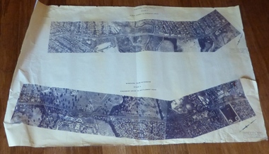
Drawing, Melbourne & Metropolitan Tramways Board (MMTB), Aerial photographs Bundoora Tram Extensions, Plenty Road – MMTB Drawings – 12/1979, Bundoora Extension – Metropolitan Transit Authority – 2/1983, John-Connell – Mott Hay and Anderson – Preliminary drawings for the Latrobe Modal Interchange – August 1984, 1979 to 1984
Set of drawings for the MMTB Plenty Road extension in 1979, MTA extension to Bundoora in 1983 and the Latrobe Uni Modal Interchange - 1984. Large print – Aerial photographs Bundoora Tram Extensions Stage 2 – Albert St to Kingsbury Drive Stage 3 – Kingsbury Drive to Settlement Road Has been rolled, left hand edge damaged, right hand edge torn Compiled by the ROW Division – 2/1981. Has written on rear at right hand end “Bundoora Tram Extension – Official MMTB Plans” 760H x 1190W Plenty Road – MMTB Drawings – 12/1979 P15123 Tyler St to Walsal Avenue P15124 Walsal Ave t McColl St P15125 McColl St to Dorrington Avenue Bundoora Extension – Metropolitan Transit Authority – 2/1983 P15400 Dorrington Avenue to Barwon Avenue P15401 Barwon Avenue to Nicholson Ave P15402 Nicholson St to Barling Park P15403 Barling Park to Darebin Creek P15404 Darebin Creek to Scott Grove P15405 Scott Grove to Clunes Street P15406 Clunes St to Cash St P15408 Cash St to Bundoora Park P15409 Bundoora Park to Larundel Hospital P15410 At Larundel Hospital P15411 Larundel Hospital to Marne Court P15412 Marne Court to Cherrywood Court P15413 Cherrywood Court to Morwell Ave P15414 Morwell Ave to Grimshaw St P15415 Grimshaw St to Nickson Street P15416 Nickson St to McLeans Road John-Connell – Mott Hay and Anderson – Preliminary drawings for the Latrobe Modal Interchange – August 1984. 8094-A-20 Set Out Plan and Paving Details 8094-A-21 Elevations 8094-A-22 Sections 8094-A-23 Roof Plan and Stormwater Layout 8094-A-24 Canopy Details 8094-A-25 Toilet Block and Waiting Room 8094-A-28 Miscellaneous DetailsOn rear of aerial photograph sheet - at right hand end “Bundoora Tram Extension – Official MMTB Plans” in felt pen.trams, tramways, plenty rd, bundoora, latrobe university, mmtb, construction, mta -
 Victoria Police Museum
Police Stations (Armadale)
Armadale is an inner suburb of Melbourne, Victoria, Australia, 7 km south-east of Melbourne's Central Business District, located within the City of Stonnington local government area. Armadale Police Station opened, in Melbourne Police District, on 11 May 1885. Its original location is unknown, but in 1890 it is listed in the Sands & McDougall directory as at 295 Hight Street. From 1985-1920 it was located at 20/22 Auburn Grove, 1925-1930 at 769 High Street and 1935-1946 at 3 Cheel Street. The station closed on 28 January 1946. The sub-division east of Orrong Rd was incorporated into Malvern Sub-district and west of Orrong Road into Prahran Sub-district. In a special 1930 issue of the Victoria Police Gazette the Armadale Police Station was described as a seven-roomed brick dwelling with a tiled roof on land measuring 127' x 104' x 98'. There was also a bathroom and W.C., a wash-house, office, and a lock-up (one cell). This is probably a description of the Cheel Street police station. It was staffed by one senior constable and three foot constables.12 photographs comprising 8 coloured images and 4 black and white images 1 sketch plan of Old Armadale Police Stationpolice stations; armadale police station -
 Melton City Libraries
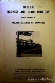
Booklet, Melton Business and Trade Directory, c.1965
BUSINESS TRADE AND DIRECTORY MAP NORTH of High Street RALIEGHS Road - Early settlers Oliver Reierson ( Norwegian) Raliegh SHEBLER Court Auguste EMIL Court Jongebloed Family residence “Hemlich” ALEXANDRA Street Coronation King, Queen Alexandra - 1903 O’NEILS Road Farmer OLDERSHAW Road CORR Grove Early landowner, Teacher at the Common School – Denominational Churches, 1850’s Wesleyan (Methodist) BRYAN Court 1850’s resident renamed from earliest town site - Flat HURLEY Street Early settler and farmers - CHESNEY Road was named Minns, due to duplication altered to Chesney (Minns) SOUTH of High ALKEMADE Drive. Family name ARNOLD Court Family BARRIES Road Charles Ernest Barrie “Darlingsford” 1911 Residence KILPATRICKS Road became Barries Road west of Station Road BLACKWOOD Drive Alexander, Early settler CALLANAN Drive Surveyor early LUBY Court John Luby - Crown Grant Land title KERWIN Street Michael - Crown Grant land title (deleted due to Freeway)Pamphlet of Melton Businesses and map of the townlocal identities, misc., council -
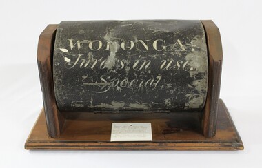 Wodonga & District Historical Society Inc
Functional object - Jurors' Selection Barrel, Wodonga Court House
The barrel was used in the Wodonga Court House as part of the selection process for jurors. It was a standard issue barrel used throughout Victoria. It was retrieved from the ruins of the court house which was destroyed by fire. It was then donated to the Wodonga Historical Society. The timber display stand was made and donated by Jake Tooley, a Wodonga Historical Society member, The Court House was situated in the Customs Store building alongside the Wodonga Police Station in 93 High Street. (The house where the Police Station was had originally been the home of the Customs Officer). In early 1964, the court house building was burnt beyond repair and furniture and other property destroyed. The cause of the fire was never found. The Police Station was lucky to survive but only because of the efforts of the local Fire Brigade. After the fire, the court was held first at the old Fire Station premises near where the Wodonga Post Office is near Woodland Grove, then it moved to a vacant building in Mitchell Street which was later turned into a Child Care Centre. Foundations for the new court house in Elgin Street were laid in October 1965 Local significance due to its use in the Wodonga Court House and its survival of a major fire. State significance as it documents a procedure used in the Victorian Court and Legal system Cylindrical metal-iron barrel painted black with writing stenciled on the front in white The timber mount was made for storage and display is not part of the original object,Inscription on Barrel "WODONGA./ Jurors in use./ Special"wodonga court, jurors, selection, legal system, fire -
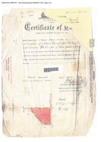
 Ringwood and District Historical Society
Document, Certificate of Title - Alexander William Brown - part of Crown Section 20, Parish of Warrandyte, County of Evelyn - 16th April, 1948
A4 copies of Landata Victoria Historical Search documents - Vol 7141 Fol 1428080.Alexander William Brown of Grandview Grove (later Bemboka Road), Ringwood is now the proprietor of an Estate in Fee-simple subject to the Encumbrances notified hereunder ... 2 acres 3 roods 24 and one-half perches or thereabouts, being Lots 33 and 34 Kardinia Crescent, on Plan of Subdivision no.12040. Transfers include Alexander William Brown died 25th June, 1957, Probate granted 28th January, 1958, to Alfred Hart Brown of Dandenong, Estate Agent, and Harry Britten Elms of Cardinia, Gentleman, Oliver Burgess, Grandview Grove Ringwood, Florist - 14th May, 1964, Peter John Woodhead, Transport driver, and Shirley Margaret Woodhead, Married woman - 12th September, 1966. Inventory of Real Estate Assets (for Probate purposes 4/10/1957) detailed in Family Genealogy record for A.W. Brown includes: "Kardinia Crescent, Ringwood - Land containing 2 acres 3 roods 24-1/2 perches situate in Kardinia Crescent Ringwood being Lots 33 and 34 on Plan of Subdivision Number 12040 and being part of Crown Section 20 Parish of Warrandyte County of Evelyn and being the land described in Certificate of Title Volume 7141 Folio 080 valued by E. Miles at £350:0:0 -
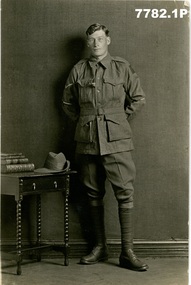 Bendigo Military Museum
Postcard - POSTCARDS, PHOTOGRAPHIC WW1, Edgar Dawson collection : Battalion comrades, 1915-1919
This six-postcard group is the third in a series of records of items in the collection of Edgar Dawson DCM. Dawson was the Regimental Sergeant Major of 57th Battalion, AIF. The 57th had a company of men largely from Bendigo and Eaglehawk. These postcards are from his personal album. Many are annotated in Dawson's hand with explanatory notes on the subject. Refer to Cat No 893 for his service details. Items originally in album cat. no. 207P Service details available through the NAA. Physical description Collection of six photo postcards B+W 1. Portrait of Richards, John 3593 57th Btn 2. Portrait of Moore, Charles 4593 57th Btn 3. Portrait of Mitchell, Leslie Fenen 4854 57th Btn 4. Portrait of Hutson, Herbert Spence 3540 57th Btn 5. Portrait of Steele, Leslie William 2737 57th Btn 6. Portrait of Spinks, William Edward 2239 57 Btn1. On verso "L.Cpl J Richards, St Killians Road, White Hills Bendigo Victoria 6-10-17" 2. On verso, "Chas Moore, 9-9-17" 3. On verso "Pt L.F. Mitchell, No 4854, 13th reinforcements, 29th Battalion, AIF Abroad" 4. On verso "This is one of our gallant runners France 1917" "Herbert S. Hutson, Lemon Grove, Heathcote Victoria" 5. On verso "With best wishes L Steele 10-2-18", "L. Steele, Balmoral Street, Essendon, Melbourne Australia" 6. On verso "W.E.Spinks, Templeton Street, Euroa, Victoria, Australia"postcards, 57th battalion, edgar dawson dcm -
 Ringwood and District Historical Society
Document, Certificate of Title - Edward Thomas Miles, Gentleman, "Woorara", Ringwood - part of Crown Section 20, Parish of Warrandyte, County of Evelyn - 1913
A4 copies of damaged Landata Victoria Historical Search documents - Vol 3726 Fol 200 - incomplete proprietor and transfer details.Edward Thomas Miles is now the proprietor of an Estate in Fee-simple subject to the Encumbrances notified hereunder ... 27 acres 19 perches or thereabouts, together with a right of carriage way over roads coloured brown. Subdivision map includes un-named roads - western side is Wonga Road (later Warranwood Road), and eastern side is Grandview Grove (later Bemboka Road), both north of Plymouth Road, Ringwood, Vic. Transfers include (illegible) Dobbs, November, 1927 - 5 acres Harry Temple Marshall, 1st December, 1928 - 10ac 3r David Edward Meyland, 4th October, 194-? (illegible). -
 Old Colonists' Association of Ballarat Inc.
Photograph - Photograph - Colour, Ballarat Old Colonists' Association Homes, Charles Anderson Grove, Ballarat
HISTORY OF THE BALLARAT OLD COLONISTS' ASSOCIATION HOMES AT CHARLES ANDERSON GROVE, LAKE GARDENS One of the original objectives of the Association was “to provide the shelter of a house for those Pioneers of the Goldfields whom the reverses of fortune have deprived of the means of procuring the comforts of life in their declining years.” While the first home at Charles Anderson Grove was built in 1925 the Association had previously provided relief for needy pioneers from the time it was formed in 1883. Relief included monthly monetary payments, loads of firewood, medical assistance and distribution of Christmas boxes of groceries to deserving pensioners and in some cases payment of burial costs. Records indicate that in September 1922 three of the pensioners being assisted by the Association were accepted as residents in the newly erected Hassell Homes in Gillies Street (now demolished-opposite the High School). The first site for an Asylum for Indigent Members of the Old Colonists' Association was temporarily reserved from sale in October 1891. The site was approximately 28 acres in area in Mt Clear nearly opposite Midvale Shopping Centre in Main Road. The site was heavily timbered and when cleared over 260 tons of wood was sold to the Woah Hawp Gold Mining Company. A set of gates were erected but no homes built, although a plan for this reserve was drawn which showed twenty buildings ranging from one to four unit per building. The reserve was revoked in November 1909. The second site temporarily reserved in November 1909 as an Asylum was in Alfredton and consisted of some 7 acres and was adjacent to land reserved for an Abattoirs for the Ballarat Council. The reserve was revoked in February 1912 as it was deemed more appropriate to be added to the Abattoir site. Council suggested four (4) other sites in exchange for this land and they were inspected by the President, Vice President and Secretary on 22 December 1912. The first site inspected was land on the west side of Creswick Road opposite the brick kilns (now occupied by the showgrounds and oval). The land was described as being good quality, well fenced, no trees, good drainage and ample acreage but some distance from trams. The second site was Perry Park which was described as being good land, well fenced, having frontage to Gillies Street, good drainage and about 26 acres (but subsequently reduced to 10 acres). It was closely planted with Pinus Insignias and Wattle and had easy access from the Botanic Gardens tram. The third site was the North West portion of Victoria Park (corner of Sturt and Gillies Street) and was described as good land, well fenced and drained and well located. The fourth site was the South West corner of Victoria Park and known as Pound Paddock (corner of Winter Street and Gillies Street). It was considered to be low lying and too close to the Abattoir, and was also a considerable distance from trams. While the third site was recommended as the most suitable for the erection of homes it was considered unwise from the point of view as citizens to reduce the acreage of the park and therefore it was recommended that the Perry Park site be asked for as the most acceptable to the Association for the building of homes. The site was eventually temporarily reserved for an Asylum for Indigent Members of the Association in April 1914 with the gates from Mt Clear having been removed to the site a year earlier and eventually erected in 1917 for £12.10.0. In the same year the first 290 pine trees were advertised for removal in July and sold for £16. A sign indicating that the site was reserved for the erection of cottages was erected in September 1917. Stripping of the wattle bark (for tanning) and the cutting of the wood occurred in November 1918 with the land then being leased until it was required for the construction of the first homes in 1924. While the site was the third to be reserved it was the only one which was used for its intended purpose. It was named as Charles Anderson Grove in honour of Charles Anderson who joined the Association in 1918 and was President of the Association from 1942 to 1944. A number of cottages in the Ballarat Old Colonists' Association Retirement Village of Gillies Street, Ballarat.charles anderson grove, old colonists' club, ballarat, old colonists' association, old colonists' homes, retirement village -
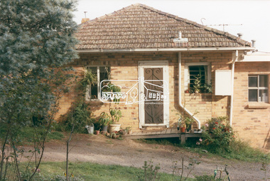 Eltham District Historical Society Inc
Photograph, 218 Pitt Street, Eltham, c.1985, 1985c
House was rented by Kim Tarpey between October 1983 and June 1985. It was one of the buildings originally part of Birds Orchard. Harold Bird was her landlord, a retired primary school teacher who, when she knew him was driving the mobile library bus. Her partner had him as a teacher at Montmorency Primary in grade 4. The house was next door to what is now a bushland reserve near the Pauline Toner Reserve. It was on the corner of Pitt and Arthur St - the driveway was near the roundabout and went off to the right of the driveway that now belongings to 220 Pitt street and which was bushland at the time. It was sold in 1985 and consequently demolished, a large house has replaced it. It was situated approximately where the front door of No. 218 is nowadays with the facade roughly in line with the now garage wall to the left of this front door.Digital file only - scanned from personal photo album on loan (27 images) List of images EDHS_04644-1.tif Kitchen window looking towards Eucalyptus Road, 218 Pitt Street, Eltham, c.1985 EDHS_04644-2.tif 218 Pitt Street, Eltham, c.1985 EDHS_04644-3.tif 218 Pitt Street, Eltham, c.1985 EDHS_04644-4.tif Kitchen looking towards Pitt Street Reserve, 218 Pitt Street, Eltham, c.1985 EDHS_04644-5.tif 218 Pitt Street, Eltham, c.1985 EDHS_04644-6.tif Bathroom walkway/laundry, 218 Pitt Street, Eltham, c.1985 EDHS_04644-7.tif 218 Pitt Street, Eltham, c.1985 EDHS_04644-8.tif 218 Pitt Street, Eltham, c.1985 EDHS_04644-9.tif 218 Pitt Street, Eltham, c.1985 EDHS_04644-10.tif 218 Pitt Street, Eltham, c.1985 EDHS_04644-11.tif 218 Pitt Street, Eltham, c.1985 EDHS_04644-12.tif 218 Pitt Street, Eltham, c.1985 EDHS_04644-13.tif 218 Pitt Street, Eltham, c.1985 EDHS_04644-14.tif 218 Pitt Street, Eltham, c.1985 EDHS_04644-15.tif 218 Pitt Street, Eltham, c.1985 EDHS_04644-16.tif 218 Pitt Street, Eltham, c.1985 EDHS_04644-17.tif Lounge window looking towards Mount Pleasant Road, 218 Pitt Street, Eltham, c.1985 EDHS_04644-18.tif Fire place in lounge, 218 Pitt Street, Eltham, c.1985 EDHS_04644-19.tif Fire place in lounge, 218 Pitt Street, Eltham, c.1985 EDHS_04644-20.tif View from lounge room window looking towards corner of Eucalyptus and Mount Pleasant roads, 218 Pitt Street, Eltham, c.1985 EDHS_04644-21.tif View from lounge room window looking towards corner of Eucalyptus and Mount Pleasant roads, 218 Pitt Street, Eltham, c.1985 EDHS_04644-22.tif View from lounge room looking towards Pitt Street and Wattle Grove, 218 Pitt Street, Eltham, c.1985 EDHS_04644-23.tif View from lounge room looking towards Pitt Street and Wattle Grove, 218 Pitt Street, Eltham, c.1985 EDHS_04644-24.tif 218 Pitt Street, Eltham, c.1985 EDHS_04644-25.tif Back garden showing previous tank stumps. There was a hole in the wall where a possum got through, 218 Pitt Street, Eltham, c.1985 EDHS_04644-26.tif View from back fence looking towards Pitt Street and Wattle Grove, 218 Pitt Street, Eltham, c.1985 EDHS_04644-27.tif View from back fence on to Eucalyptus Road. Pitt Street Reserve to the right, 18 Pitt Street, Eltham, c.1985218 pitt street, eltham, houses, birds orchard, harold bird, kim tarpey, eucalyptus road -
 Eltham District Historical Society Inc
Photograph, Belle Vue, Livingstone Road, Eltham, c.1960, 1960c
Photo taken at time of ownership by Eric Staff. Originally purchased by pioneer Eltham farmer Henry Stooke, Belle Vue farm comprised about 56 ha (140 acres) extending northerly from the northern boundary of Holloway’s 1851 Little Eltham subdivision. On the present day map the southern boundary was just north of Elsa Court and Grove Street. The western boundary was the Diamond Creek and extended northerly to Main Road where it turns easterly towards Research. It was traversed by the main road to Kangaroo Ground and beyond and from 1912 by the railway to Hurstbridge. From 1895 the farm was owned by William Williams and his wife Mary Ann. In 1914-1915 they built a new house now known as “Belle Vue”. They sold the land in 1920 and residential subdivision began soon after that. “Belle Vue” remains today on a large residential lot in Livingstone Road. The house and many old trees on the site have been subject to a heritage overlay under the Nillumbik Planning Scheme. Despite that overlay, most of the heritage trees were removed during sub-division and development of the property.Digital file only from scan of copy on loan to EDHSbelle vue, eltham, eric staff, houses, livingstone road, staff family -
![Uniform - School Uniform, Woodbury Ladies’ College [Kew] Badge, circa 1918, c.1918](/media/collectors/550653872162f11fb04854aa/items/5e89f58a21ea671a7c03d0c9/item-media/5e89f65821ea671a7c0508fc/item-fit-380x285.jpg) Kew Historical Society Inc
Kew Historical Society IncUniform - School Uniform, Woodbury Ladies’ College [Kew] Badge, circa 1918, c.1918
Woodbury College was an indirect predecessor of Preshil School in Kew. Woodbury College was founded in Glenferrie Road by a Miss Harcourt, former principal of Sydenham College, Moonee Ponds. Miss Harcourt maintained the school until the goodwill was purchased in 1908 by Miss LJ Macey, who had previously operated Lillsden Ladies' College in Edgevale Road, between c.1891 and c.1903. The first school was in a rented building on the south side of Cotham Road between Atkins and Davis Streets. In 1910, a new school building was built on the corner of Uvadale Grove and Cotham Road [the building is still extant as of 2020]. Woodbury College was operated by Miss LJ and Miss HJ Macey until 1920. In 1921, the school amalgamated with the newly formed St Andrew's College, Mont Victor Road, Kew (Vic) under the leadership of Rev JT Lawton [who had previously been principal of St Andrew's School of the 'Pathfinder' in South Yarra]. Miss Macey was for a period the Headmistress of the amalgamated school. Another teacher at the school was Miss Margaret JR Lyttle, who in 1931, left St Andrew's to form the Preshil School.Rare ephemera relating to an early private school in Kew (Vic). The badge was donated by Helen Lade.Brass school badge which includes the initials WL within a large C, surrounded with the school crest - VERITAS VINCIT [Truth Prevails] of Woodbury Ladies College (1903-1920). woodbury college, schools - cotham road - kew - vic, private schools - kew (vic)