Showing 1834 items matching "rivers in victoria"
-
 Bendigo Historical Society Inc.
Photograph - Historical Society Field Trip to the Springs at Sedgwick, Abt 2009
The Phil Wilkin Collection contains a series of 11 Items. The related items can be found by clicking on the reference link below. The following history of the Young family and their descendants who lived at the Springs is provided by Phil Wilkin. His Great Grandparents were Frances Young and August Wirth. Phil has also provided notes on the Wilkin Family and some history of the gold mining in Sedgwick. Frances Young's parents Joseph and Margaret Young owned the property called "The Old Place, Preston Vale or Wellington Flat" at Sedgwick near the Springs. Joseph Young owned and Managed the Standard Brewery which was located at Campbells Creek during the late 1800’s early 1900’s. Joseph and Margaret are buried in the Harcourt cemetery. In 1880 August Wirth lived at Mosquito Creek (Lake Eppalock, Victoria) when he married Frances Young. In 1902 they moved to part of Joseph Young's property. They milked cows and sold cattle for a living. One of their children Charles Wirth (Phil Wilkin's Grandfather) bought the land in 1935 after his parents had died. Charles Wirth was a councillor and also was president of the Shire of Strathfieldsaye. The "Old Place" was part of the property owned by members of the family. The old house at the Springs was burnt out by bushfire in January 1944 and much of the stonework was later vandalized by campers. The original Coliban Water Works were designed in 1863 by the Irish engineer Joseph Brady. The system included 70 kilometres of open water channels, aqueducts, syphons and tunnels to carry water (by gravity) from the Coliban River at Malmsbury, north to Castlemaine and Bendigo. Sedgwick is a locality in Central Victoria, Australia. It is located in the City of Greater Bendigo. Facilities include a public hall that opened in 1958 and CFA Rural fire station. It was named Upper Emu Creek until 1901 when it was renamed as Sedgwick after British geologist Adam Sedgwick.Twenty six photos taken on a field trip by the Bendigo Historical Society to "The Springs" on the main Coliban water channel from Malmsbury to the Sandhurst Reservoir in Bendigo. The water race descends through a concrete chute, and continues sharply around the contour of the hills. Once it descended into a syphon across the gully. The are 182 photos in this series and can be found at 8683.1 to 8683.11. The series also includes photos of the surrounding farming land and the remains of an old house. There are also some notes on the pioneers of the district.history, bendigo, coliban water, joseph brady, irrigation, the springs, sedgwick -
 Bendigo Historical Society Inc.
Photograph - Historical Society Field Trip to the Springs at Sedgwick, Abt 2009
The Phil Wilkin Collection contains a series of 11 Items. The related items can be found by clicking on the reference link below. The following history of the Young family and their descendants who lived at the Springs is provided by Phil Wilkin. His Great Grandparents were Frances Young and August Wirth. Phil has also provided notes on the Wilkin Family and some history of the gold mining in Sedgwick. Frances Young's parents Joseph and Margaret Young owned the property called "The Old Place, Preston Vale or Wellington Flat" at Sedgwick near the Springs. Joseph Young owned and Managed the Standard Brewery which was located at Campbells Creek during the late 1800’s early 1900’s. Joseph and Margaret are buried in the Harcourt cemetery. In 1880 August Wirth lived at Mosquito Creek (Lake Eppalock, Victoria) when he married Frances Young. In 1902 they moved to part of Joseph Young's property. They milked cows and sold cattle for a living. One of their children Charles Wirth (Phil Wilkin's Grandfather) bought the land in 1935 after his parents had died. Charles Wirth was a councillor and also was president of the Shire of Strathfieldsaye. The "Old Place" was part of the property owned by members of the family. The old house at the Springs was burnt out by bushfire in January 1944 and much of the stonework was later vandalized by campers. The original Coliban Water Works were designed in 1863 by the Irish engineer Joseph Brady. The system included 70 kilometres of open water channels, aqueducts, syphons and tunnels to carry water (by gravity) from the Coliban River at Malmsbury, north to Castlemaine and Bendigo. Sedgwick is a locality in Central Victoria, Australia. It is located in the City of Greater Bendigo. Facilities include a public hall that opened in 1958 and CFA Rural fire station. It was named Upper Emu Creek until 1901 when it was renamed as Sedgwick after British geologist Adam Sedgwick.Twenty five photos taken on a field trip by the Bendigo Historical Society to "The Springs" on the main Coliban water channel from Malmsbury to the Sandhurst Reservoir in Bendigo. The water race descends through a concrete chute, and continues sharply around the contour of the hills. Once it descended into a syphon across the gully. The are 182 photos in this series and can be found at 8683.1 to 8683.11. The series also includes photos of the surrounding farming land and the remains of an old house. There are also some notes on the pioneers of the district.history, bendigo, coliban water, joseph brady, irrigation, the springs, sedgwick -
 Bendigo Historical Society Inc.
Photograph - The Young and Wirth Families at Preston Vale, near the Springs Sedgwick, 1880s-1900s
The Phil Wilkin Collection contains a series of 11 Items. The related items can be found by clicking on the reference link below. The following history of the Young family and their descendants who lived at the Springs is provided by Phil Wilkin. His Great Grandparents were Frances Young and August Wirth. Phil has also provided notes on the Wilkin Family and some history of the gold mining in Sedgwick. Frances Young's parents Joseph and Margaret Young owned the property called "The Old Place, Preston Vale or Wellington Flat" at Sedgwick near the Springs. Joseph Young owned and Managed the Standard Brewery which was located at Campbells Creek during the late 1800’s early 1900’s. Joseph and Margaret are buried in the Harcourt cemetery. In 1880 August Wirth lived at Mosquito Creek (Lake Eppalock, Victoria) when he married Frances Young. In 1902 they moved to part of Joseph Young's property. They milked cows and sold cattle for a living. One of their children Charles Wirth (Phil Wilkin's Grandfather) bought the land in 1935 after his parents had died. Charles Wirth was a councillor and also was president of the Shire of Strathfieldsaye. The "Old Place" was part of the property owned by members of the family. The old house at the Springs was burnt out by bushfire in January 1944 and much of the stonework was later vandalized by campers. The original Coliban Water Works were designed in 1863 by the Irish engineer Joseph Brady. The system included 70 kilometres of open water channels, aqueducts, syphons and tunnels to carry water (by gravity) from the Coliban River at Malmsbury, north to Castlemaine and Bendigo. Sedgwick is a locality in Central Victoria, Australia. It is located in the City of Greater Bendigo. Facilities include a public hall that opened in 1958 and CFA Rural fire station. It was named Upper Emu Creek until 1901 when it was renamed as Sedgwick after British geologist Adam Sedgwick.Thirty Four Photos of Joseph Young's property near "The Springs" on the main Coliban water channel from Malmsbury to the Sandhurst Reservoir in Bendigo. This item contains family history of Joeph's descendant Charles Wirth, who was a councillor for the Shire of Strathfieldsaye. The water race descends through a concrete chute, and continues sharply around the contour of the hills. Once it descended into a syphon across the gully. The are 182 photos in this series and can be found at 8683.1 to 8683.11. The series also includes photos of the surrounding farming land and the remains of an old house. There are also some notes on the pioneers of the district.history, bendigo, coliban water, joseph brady, irrigation, the springs, sedgwick, charles wirth, preston vale, joseph and margaret young, standard brewery campbells creek harcourt, phil wilkin collection -
 Bendigo Historical Society Inc.
Photograph - The Sedgwick Gold Mine, abt 1909
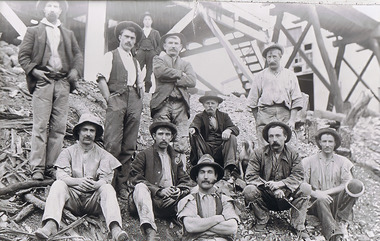
The Phil Wilkin Collection contains a series of 11 Items. The related items can be found by clicking on the reference link below. The following history of the Young family and their descendants who lived at the Springs is provided by Phil Wilkin. His Great Grandparents were Frances Young and August Wirth. Phil has also provided notes on the Wilkin Family and some history of the gold mining in Sedgwick. Frances Young's parents Joseph and Margaret Young owned the property called "The Old Place, Preston Vale or Wellington Flat" at Sedgwick near the Springs. Joseph Young owned and Managed the Standard Brewery which was located at Campbells Creek during the slate 1800’s early 1900’s. Joseph and Margaret are buried in the Harcourt cemetery. In 1880 August Wirth lived at Mosquito Creek (Lake Eppalock, Victoria) when he married Frances Young. In 1902 they moved to part of Joseph Young's property. They milked cows and sold cattle for a living. One of their children Charles Wirth (Phil Wilkin's Grandfather) bought the land in 1935 after his parents had died. Charles Wirth was a councillor and also was president of the Shire of Strathfieldsaye. The "Old Place" was part of the property owned by members of the family. The old house at the Springs was burnt out by bushfire in January 1944 and much of the stonework was later vandalized by campers. The original Coliban Water Works were designed in 1863 by the Irish engineer Joseph Brady. The system included 70 kilometres of open water channels, aqueducts, syphons and tunnels to carry water (by gravity) from the Coliban River at Malmsbury, north to Castlemaine and Bendigo. Sedgwick is a locality in Central Victoria, Australia. It is located in the City of Greater Bendigo. Facilities include a public hall that opened in 1958 and CFA Rural fire station. It was named Upper Emu Creek until 1901 when it was renamed as Sedgwick after British geologist Adam Sedgwick.Four photos of the miners and information on the Sedgwick Gold Mine. There are 182 photos in this series and can be found at 8683.1 to 8683.11. The series also includes photos of the surrounding farming land and the remains of an old house. There are also some notes on the pioneers of the district.history, bendigo, coliban water, joseph brady, irrigation, the springs, sedgwick, phil wilkin collection, sedgwick gold mine -
 Bendigo Historical Society Inc.
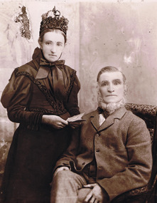
Photograph - Joseph and Margaret Young from Preston Vale (near The Springs) Sedgwick, 1800s-1900s
The Phil Wilkin Collection contains a series of 11 Items. The related items can be found by clicking on the reference link below. The following history of the Young family and their descendants who lived at the Springs is provided by Phil Wilkin. His Great Grandparents were Frances Young and August Wirth. Phil has also provided notes on the Wilkin Family and some history of the gold mining in Sedgwick. Frances Young's parents Joseph and Margaret Young owned the property called "The Old Place, Preston Vale or Wellington Flat" at Sedgwick near the Springs. Joseph Young owned and Managed the Standard Brewery which was located at Campbells Creek during the late 1800’s early 1900’s. Joseph and Margaret are buried in the Harcourt cemetery. In 1880 August Wirth lived at Mosquito Creek (Lake Eppalock, Victoria) when he married Frances Young. In 1902 they moved to part of Joseph Young's property. They milked cows and sold cattle for a living. One of their children Charles Wirth (Phil Wilkin's Grandfather) bought the land in 1935 after his parents had died. Charles Wirth was a councillor and also was president of the Shire of Strathfieldsaye. The "Old Place" was part of the property owned by members of the family. The old house at the Springs was burnt out by bushfire in January 1944 and much of the stonework was later vandalized by campers. The original Coliban Water Works were designed in 1863 by the Irish engineer Joseph Brady. The system included 70 kilometres of open water channels, aqueducts, syphons and tunnels to carry water (by gravity) from the Coliban River at Malmsbury, north to Castlemaine and Bendigo. Sedgwick is a locality in Central Victoria, Australia. It is located in the City of Greater Bendigo. Facilities include a public hall that opened in 1958 and CFA Rural fire station. It was named Upper Emu Creek until 1901 when it was renamed as Sedgwick after British geologist Adam Sedgwick.12 photos and historical document of Joseph and Margaret Young. There are 182 photos in this series and can be found at 8683.1 to 8683.11. The series also includes photos of the surrounding farming land and the remains of an old house. There are also some notes on the pioneers of the district.history, bendigo, coliban water, joseph brady, irrigation, the springs, sedgwick, phil wilkin collection, standard brewery campbells creek, joeseph and margaret young -
 Bendigo Historical Society Inc.
Photograph - The Wilkin Family of Sedgwick, 1800s-1900s
The Phil Wilkin Collection contains a series of 11 Items. The related items can be found by clicking on the reference link below. The following history of the Young family and their descendants who lived at the Springs is provided by Phil Wilkin. His Great Grandparents were Frances Young and August Wirth. Phil has also provided notes on the Wilkin Family and some history of the gold mining in Sedgwick. Frances Young's parents Joseph and Margaret Young owned the property called "The Old Place, Preston Vale or Wellington Flat" at Sedgwick near the Springs. Joseph Young owned and Managed the Standard Brewery which was located at Campbells Creek during the late 1800’s early 1900’s. Joseph and Margaret are buried in the Harcourt cemetery. In 1880 August Wirth lived at Mosquito Creek (Lake Eppalock, Victoria) when he married Frances Young. In 1902 they moved to part of Joseph Young's property. They milked cows and sold cattle for a living. One of their children Charles Wirth (Phil Wilkin's Grandfather) bought the land in 1935 after his parents had died. Charles Wirth was a councillor and also was president of the Shire of Strathfieldsaye. The "Old Place" was part of the property owned by members of the family. The old house at the Springs was burnt out by bushfire in January 1944 and much of the stonework was later vandalized by campers. The original Coliban Water Works were designed in 1863 by the Irish engineer Joseph Brady. The system included 70 kilometres of open water channels, aqueducts, syphons and tunnels to carry water (by gravity) from the Coliban River at Malmsbury, north to Castlemaine and Bendigo. Sedgwick is a locality in Central Victoria, Australia. It is located in the City of Greater Bendigo. Facilities include a public hall that opened in 1958 and CFA Rural fire station. It was named Upper Emu Creek until 1901 when it was renamed as Sedgwick after British geologist Adam Sedgwick.17 photos and historical document of the Wilkin Family associated with the Springs near Sedgwick. There are 182 photos in this series and can be found at 8683.1 to 8683.11. The series also includes photos of the surrounding farming land and the remains of an old house. There are also some notes on the pioneers of the district.history, bendigo, coliban water, joseph brady, irrigation, the springs, sedgwick, phil wilkin collection, standard brewery campbells creek, joeseph and margaret young, wilkin family -
 Bendigo Historical Society Inc.
Photograph - The Wilkin Family of Sedgwick - Isaac and Letitia Barcley, 1800s-1900s
The Phil Wilkin Collection contains a series of 11 Items. The related items can be found by clicking on the reference link below. The following history of the Young family and their descendants who lived at the Springs is provided by Phil Wilkin. His Great Grandparents were Frances Young and August Wirth. Phil has also provided notes on the Wilkin Family and some history of the gold mining in Sedgwick. Frances Young's parents Joseph and Margaret Young owned the property called "The Old Place, Preston Vale or Wellington Flat" at Sedgwick near the Springs. Joseph Young owned and Managed the Standard Brewery which was located at Campbells Creek during the late 1800’s early 1900’s. Joseph and Margaret are buried in the Harcourt cemetery. In 1880 August Wirth lived at Mosquito Creek (Lake Eppalock, Victoria) when he married Frances Young. In 1902 they moved to part of Joseph Young's property. They milked cows and sold cattle for a living. One of their children Charles Wirth (Phil Wilkin's Grandfather) bought the land in 1935 after his parents had died. Charles Wirth was a councillor and also was president of the Shire of Strathfieldsaye. The "Old Place" was part of the property owned by members of the family. The old house at the Springs was burnt out by bushfire in January 1944 and much of the stonework was later vandalized by campers. The original Coliban Water Works were designed in 1863 by the Irish engineer Joseph Brady. The system included 70 kilometres of open water channels, aqueducts, syphons and tunnels to carry water (by gravity) from the Coliban River at Malmsbury, north to Castlemaine and Bendigo. Sedgwick is a locality in Central Victoria, Australia. It is located in the City of Greater Bendigo. Facilities include a public hall that opened in 1958 and CFA Rural fire station. It was named Upper Emu Creek until 1901 when it was renamed as Sedgwick after British geologist Adam Sedgwick.Seven historical documents of Isacc and Letitia Barcley who were associated with the Wilkin Family and also with the Springs near Sedgwick. There are 182 photos in this series and can be found at 8683.1 to 8683.11. The series also includes photos of the surrounding farming land and the remains of an old house. There are also some notes on the pioneers of the district.history, bendigo, coliban water, joseph brady, irrigation, the springs, sedgwick, phil wilkin collection, joeseph and margaret young, letitia and isacc barclay -
 Bendigo Historical Society Inc.
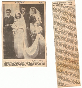
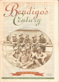
Newspaper - LONG GULLY HISTORY GROUP COLLECTION: BENDIGO'S CENTURY VOLUME FIVE: 1940 - 1949
Newspaper supplement titled Bendigo's Century Volume Five: 1940 - 1949. Each year has heading of Who's Who, Weather, Sport and Business. Front page is titled Bendigo's Century and has a photo of a group of soldiers in uniform and with rifles. They were district servicemen on leave in 1944. Each year has heading of Who's Who, Weather, Sport and Business. First years are 1940 - 1949 titled Bendigo as it was. It has two photos of women wading through the 1949 Pall Mall flood waters and one of Miners in the crib room of the Central Deborah Mine. They are Jackie Lewis, Bob Johnson, W Landy, Ryga Yates and Les Johnson. 1940 - Army moves in to racecourse, 1941 - Devastating fire at pottery, 1942 - Forces expand, 1943 - Nation's eyes on Bendigo, 1944 - News dawns of D-day landing, 1945 - City cheers the end of the war, 1946 - Celebrations begin in city, 1947 - Gallery gets top paintings, 1948 - Water plan looks good and 1949 - Flood takes a toll on city.bendigo, history, long gully history group, the long gully history group - bendigo's century - volume five: 1940 - 1949, bendigo advertiser, central deborah mine, jackie lewis, bob johnson, w landy, ryga yates, les johnson, central nell gwynne, department of defence, bendigo jockey club, 8th division, robert menzies, deborah mine, bendigo decentralisation vigilance committee, cr w h taylor, bendigo war funds organisation, the easter fair society, bendigo agricultural show committee, mr e g ham, mr j v fairbairn, cr a staples, the bendigo chamber of commerce, richard hartley smith abbott, captain harley abbott, bendigo art gallery, bill woodfull, bendigo high school, north deborah mine, boardwalk, toni riley pharmacy, windermere hotel, cr g a pethard, coliban system, north deborah mine, bendigo pottery, bendigo trades hall council, private lawrence burstall, major-general g j rankin mhr, andrew dunstan, ordnance factory, royal australian navy, hmas bendigo, sec offices, muioof, ymca, georger addlem, fred addlem, cr a j anderson, pauline buvhan thompson, leslie thompson, edward joseph leonski, bendigo football league, mr j dedman, william stephens, forest street methodist church, pte charles phillips, pte w e durward, pte t foley, william john stephens, central nell gwynne, air chief marshall sir arthur tedder, cr taylor, united nations, flying officer, r bruce tuff, flight lieutenant owens, royal air force, commonwealth war workers housing trust scheme, mr s mckinnon, bendigo decentralised vigilance committee, ravenswood estate, john lienhop mlc, margaret (peggy) brennan, strathfieldsaye shire council, school of mines, bendigo base hospital, william george ashman, ashman's tailors, bendigo jockey club, victorian football association, bendigo east swimming pool, deborah anticline, specimen hill methodist church, north deborah, adolf hitler, benito mussolini, australian 7th division, cr galvin, bendigo war funds organisation, hmas bendigo, lt-commander jackson, bendigo football league, central deborah mine, victoria day, cr truscott, bendigo gaol, lansellstowe, awas barracks, bendigo citizens committee, john cain snr, ordnance factory, bendigo agricultural society, the duke of gloucester, duchess of gloucester, bendigo tennis association, north deborah, gillies famous pies, aids & appliance shop, mrs georgina scott, dr j a neptune scott, alfred sisley, corot, daubigney, louis sonnenberg, gas employees' union, john lienhop, soldier settlement commission, burnewang estate, king george vi, princess elizabeth, lt philip mountbatten, mr e j w herbert, ansett airways, reg ansett, most rev, dr john mccarthy, dr bernard stewart, michael giudice, bendigo united breweries, bendigo lyric photo plays, bendigo sun newspaper, shamrock hotel, west bendigo progress association, alan mcdonald, south bendigo football club, albert collier, j t webbo, mervyn tresize, state rivers and water supply commission, eppalock reservoir, public works committee, bendigo rotary club, john edgar, bendigo base hospital, albert dunstan, benevolent home, magetti's wine hall, wallace reef wine hall, magetti family, albert magetti, lance galvin, bradford cotton spinnings (victoria) pty otd, arthur syer, stanley crossman, albert arthur dunstan, rev dr henry backhaus, city family hotel, lyric theatre, bank of australasia, city club hotelcolonial mutual building, r matchett & co, lansellstowe, leonard lansell, bendigo bas hospital, australian women's army service, mr hollway, kenworth (aust) ltd, foggitt jones's bacon factory, gordon sayers, sandhurst trustees, dr john drowley, alexander hislop, royal mint, north deborah mine, ironbark south mining company, central nell gwynne company, new chum syncline -
 Bendigo Historical Society Inc.
Document - JOSEPH MARTIN BRADY: DOCUMENTATION, 2004
Joseph Martin Brady documentation - two pages - life history - written by Geoff Russell 2004. With 5 item bibliography. Also - page on Brady from internet (but bad copy - printed on portrait, not landscape)Geoff Russellperson, individual, joseph martin brady, sir john coode, melbourne harbour trust, bendigo water works, brisbane board of water works, victorias north eastern railway. queensland first engineer of harbours & rivers. joseph brady. -
 Bendigo Historical Society Inc.
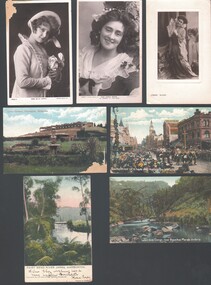
Postcard - WES HARRY COLLECTION: 7 POSTCARDS, 1905 - 09
... Victoria, (coloured) (e) Fairy Bend, River Yarra, Warburton (colour... Fairy bend River Yarra Warburton Bourke Street 8 hours day Group ...Group of seven postcards, three of them depict actresses and four are of various scenes around Victoria. (a) Miss Billie Bourke, (b) Carrie Moore, © Miss Carrie Moore as 'Honour in' Tom Jones ', (d) Bourke street on 8 hours day, Melbourne Victoria, (coloured) (e) Fairy Bend, River Yarra, Warburton (colour) (f) Werribee Gorge near Bacchus Marsh Victoria (colour) (g) Lawn Gardens, Flemington, Melbourne (colour).postcard, photograph, various themes, billie bourke, carrie moore, actresses, theatre, melbourne, flemington, werribee gorge, bacchus marsh, fairy bend, river yarra, warburton, bourke street, 8 hours day -
 Bendigo Historical Society Inc.
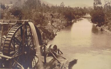
Photograph - PHOTO OF WATER WHEEL, 1900
Sepia Toned Photograph, gold sluicing on the Ovens River near Germantown) Showing a man standing on a water wheel looking over a water course flanked by trees & shrubbery with mountains in the background. Markings on rear Photo read 'N.J. Caire Landscape Photographer 4 Darling Street South Yarra Victoria'N.J. Cairephotograph, water wheel landscape, water wheel, mining -
 Victorian Interpretive Projects Inc.
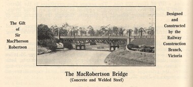
Image, MacRobertson's Bridge, 1934
Confectionery king MacPherson Robertson personally funded the £19 000 cost of the steel arch MacRobertson or Grange Road Bridge (1934) as a gift to Victoria for its centenary. (http://www.emelbourne.net.au/biogs/EM00234b.htm)A steel bridge over the Yarra River, Melbourne. The bridge was funded by MacPherson Robertson.macrobertson, bridge -
 Victorian Interpretive Projects Inc.
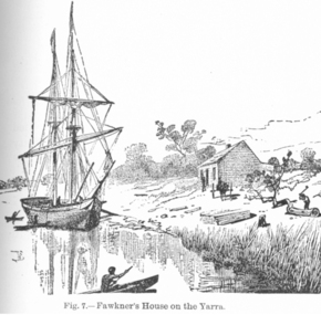
Digital Image, Fawkner's House (Melbourne), c1903
John Fawkner was an early settler of Melbourne, Victoria.Sketch of John Fawkner's house in Melbourne. The sketch shows a sailing vessel in the Yarra River.john fawkner, melbourne, yarra, yarra river, sailing boat -
 Victorian Interpretive Projects Inc.
Photograph - Colour, Clare Gervasoni, Ebenezer Mission, Antwerp, 2013, 2013
The Ebenezer Mission Station is situated by the Wimmera River and was established by Moravian missionaries as the Lake Hindmarsh Aboriginal Reserve in 1859. At its peak more than 100 people lived and worked on the mission in more than 20 buildings. The Mission closed in 1900 and was returned to the Lands Department in 1904. The church was established in the 1870s and the cemetery includes hundreds of unmarked burials. In 1961 the National Trust (Victoria) received a letter from the Horsham Historical Society expressing concern for the future of the Mission buildings. By 1971 the National Trust was managing the site. It was fenced, connected to power and the church was restored. In the mid-1970s the gravestones were in a bad state of repair. Stonemason James McCauley worked on the stones for 2 weeks. In 1991 the church was handed over to the Goolum Goolum Aboriginal Co-operative to manage. On 05 December 2013 the National Trust handed over the freehold of the Mission site. Moravian missionary Revd Paul Bogisch and his wife Amalie are buried in the cemetery. A number of colour digital photographs showing buildings on the former Ebenezer Mission at Antwerp.ebenezer, bogisch, goolum goolum, goolum, national trust, national trust (victoria), lake hindmarsh, lake hindmarsh aboriginal reserve, moravian, mission, missionary -
 Victorian Interpretive Projects Inc.
Photograph - Colour, Alexander McMillan's Bushy Park near Maffra, 2014
Alexander McMillan was a squatter and pioneer of Gippsland, Victoria. He called his run "Bushy Park" which was located on the banks of the Avon River.Colour photograph of the entrance to Bushy Park near Maffra.gippsland, maffra, bushy park, alexander mckinnon -
 Victorian Interpretive Projects Inc.
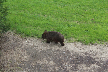
Photograph - Colour, Wombat near Maffra, Victoria, 1204, 2014
... Avon River Maffra A wombat walks along the roadway on the way ...Wombats are indigenous to Australia.A wombat walks along the roadway on the way to the Avon River, near Maffra. Once the wombat reached the river it had a good drink from the river bank.wombat, avon river, maffra -
 Victorian Interpretive Projects Inc.
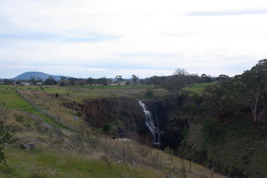
Photograph - Photograph - Colour, Clare Gervasoni, Lal Lal Falls, Victoria, 2014, 09/2014
Lal Lal Falls Reserve contains one of the most spectacular waterfalls in the Moorabool Shite. The watefall is part of the on Lal Lal Creek, a tributary of the Moorabool River. and plunges 30 metres from a high basalt column into a deep ravine. Culturally, the Falls are believed to be the earthly home of Bunjil, the All Father or Creator to most Victorian Aboriginal tribes. The name Lal Lal is thought to be Aboriginal for "dashing of waters". The Lal Lal Falls is listed on the Site Registry of Aboriginal Affairs Victoria as a spiritual place. in 1837 a Government Survey Party led by Frederick D'Arcy documented these Falls on the west branch of the Moorabool River. On the reserve opposite, a Race Meeting was held on every New Years Day from 1860 until 1938, attracting crowds of up to 20,000 people. A branch Railway Line was constructed from the Lal Lal station to the Racecourse to convey the crowds.Colour photographs of Lal Lal Falls near Ballarat, Victoria.lal lal falls, waterfall, lal lal, bunjil -
 Victorian Interpretive Projects Inc.
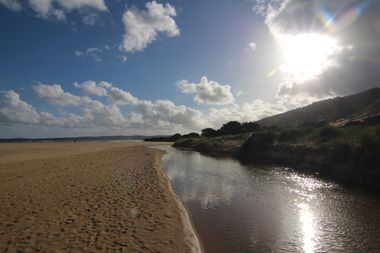
Photograph-Colour, Wild Dog Creek, Apollo Bay, 2015, 25/01/2015
Wild Dog Creek enters the sea at Apollo BayA number of colour photographs showing the mouth of Wild Dog Creek as it enters the sea at Apollo Bal, Victoria.apollo bay, sea, creek, river mouth, wold dog creek -
 Bay Steamers Maritime Museum
Framed photograph, Lindsay Rex, S. T. Wattle on low loader passing under Bolte bridge, 22/10/2009
Photogtoraph taken during the removal of Wattle from the River Yarra to its temporary storage and restoration site at No 24 South Wharf, Port Melbourne. A very significant moment in the life of the Wattle as this was the first day of the major restoration project that continues from 2009 through 2012 aiming to finish in mid 2013. Prior to this restoration project there was a long lead up to find funding and resources to restore the Wattle and ensure that Wattle was not scrapped. The majority of this preparation and restoration work was and continues to be completed by volunteers.Gilded wooden frame around a colour photograph. Steam Tug Wattle facing aft on a low loader which is passing under the Bolte Bridge. This was towards the end of the tug's land journey from Victoria Harbour to 24 South Wharf.wattle, bolte bridge, river yarra, steam tug, restoration, low loader, port melbourne -
 Myrtleford and District Historical Society
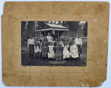
Photo, F.Foxcroft, Buffalo River South State school, 1913
... myrtleford,victoria,buffalo river, school, fletcher 1913...Buffalo River, Victoria, Australia... worn at this time myrtleford,victoria,buffalo river, school ...1913 School photo of Buffalo River South State School. The school was 21 Km south of Myrtleford. 1913 Five members of the Fletcher family attended the school : Middle Row: Agnes (far left),Elizabeth(3rd from left ) Bruce (2nd from Right)Jeanette (far right), Front Row: Jean (2nd from left) Head Master: Mr Septimus Elmore Reference from 'Recollections IV ' (The Myrtleford & district Historical Society Inc February 2011) School photo of a remote school which was greatly impacted by fluctuating enrollments ,threatening its ongoing existence. the importance of numbers from single Family. clothes worn at this time Rectangular beige stained cardboard with an inserted emboss border surrounding a Sepia color photo. Buffalo River S.S. School. F.Foxcroft photo Brightmyrtleford,victoria,buffalo river, school, fletcher 1913 -
 Dutch Australian Heritage Centre Victoria
Child-size Wooden Skates, Early 20th century
Skates were and still are widely used in winter time in The Netherlands, when the rivers, canals, creeks, ponds etc. are frozen solid. Paintings out of around 1600-1700 show models of skates very much like the one shown. Even until as recent as 40 years ago, the wooden skates (with steel blade) that are tied to the shoe with leather strap and laces, were widely used in the Netherlands. Even now they are still made in children sizes, because of there flexibility in adjusting to a range of shoe sizes.Skating is a tradition which remains popular.Wooden skates, with brown leather straps. It has a metal strip on the base of the wood, which is necessary for gliding on ice.Letter R for right foot No letter for left footdutch migration skates wood -
 Dutch Australian Heritage Centre Victoria
Etching
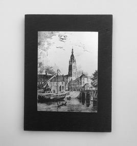
The Vliet is a canal in the western Netherlands, in the province of South Holland. It starts at the Oude Rijn at Leiden and joins the Delfshavense Schie canal at Delft. Places along its banks include Voorschoten, Leidschendam, Voorburg, The Hague and Rijswijk. The canal was dug in 47 AD under command of Roman general Corbulo, who wished to connect the river Rhine, of which the current Oude Rijn stream in Roman times was the main branch, to the Meuse estuary. It is unclear what the canal's trajectory was beyond the current city of Delft; the Delfshavense Schie canal, which connects Delft to the Nieuwe Maas river was not dug until 1389. In the Middle Ages the Vliet was an important trade link that attracted all kinds of trade, as it flowed through the heart of the County of Holland. Windmills have been constructed alongside the Vliet, including the completely renovated mill 'De salamander' in Leidschendam. The Vliet area was particularly attractive among richer families, who built their mansions along its banks.An historic small town scene etched (or possibly printed) on thin metal and subsequently fastened to a plywood backing. The delicately presented scene is said to show the intersection of Old Church Street and the Vliet Canal bridge in Voorburg, as well as a section of wharf. On the canal are one large and two much smaller vessels. A very tall crane-like construction arises from the wharf to the roof of waterside buildings. The people are soberly dressed in possibly 17th or 18th century costumes.On the reverse has been written: "Oude Kerkstraat Brug over de Vliet Voorburg". (Old Church Street; Bridge over the Vliet canal; Voorburg). However, research proves that the church is actually the Old Church in Delft, a short distance further down the Vliet Canal. -
Dutch Australian Heritage Centre Victoria
Book - Collection of 18th century prints, B.V.Foresta, Hollands Arcadia of de vermaarde Rivier Den Amstel - (Hollands's Arcadia or the famous Amstel river)
A soft cover reproduction on poor quality paper of a collection of illustrations first published in 1791. They were of the luxurious homes along the river Amstel owned by wealthy traders. -
 City of Whittlesea
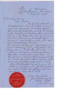
Document - Correspondence, Council letter to Mrs Moses Thomas 1868, 1878
In 1851 Moses Thomas purchased 400 acres, including a half mile frontage to the Plenty River, at Mernda (then known as Morang) where he operated a farm, inn and other business. In 1865 Moses Thomas was appointed Engineer, Clerk and Collector for the Morang District Road Board. In this role he would have been responsible for overseeing the collection of local property rates and the maintenance and construction of local roads and drains. Road District Boards were one of the earliest forms of local government in Victoria. The Morang or Upper Plenty Road District was established in 1862. It covered part of what is today Mernda, Doreen, South Morang, Mill Park and Bundoora. In 1875, the area merged with the Whittlesea Road District to form the Shire of Whittlesea. Moses Thomas briefly served as a Councillor with the Shire of Whittlesea until his death in 1878. Correspondence. Letter, paper, handwritten text with seal. Letter from James Ryan, Shire Secretary, Shire of Whittlesea to Mrs Moses Thomas on the death of Moses 18 May 1878. -
City of Whittlesea
Print (series) - Photographs - Landscapes, Fred Kruger, Fred Kruger Collection
landscapes of the plenty river regionlandscapes of the plenty river region -
 Wangaratta Historical Society
Wangaratta Historical Society
The Wangaratta Historical Society Inc. (WHS) was established in 1959 and moved into its present home in the 1970s. Wangaratta in North East Victoria has a population of over 27 thousand people and is situated at the junction of the King and the Ovens Rivers. Agriculture has always been a big part of its history as well as education, health and manufacturing. The museum was originally a fire station built 1895 and included living quarters for its staff. The building is owned by the Rural City of Wangaratta who are great supporters of the WHS The museum was bequeathed 10,000 glass negatives from the late 1800s to the 1950s these were by the Vine & Thelma studios of mostly, portraits, weddings and historical photos. Also owned by the WHS is the Maianne Gibson crazy patchwork quilt made by a Wangaratta woman in the 1890s and now Heritage listed. This Quilt is housed in an specially controlled conditions. The Wangaratta Historical Society Museum was accredited in 2012 under the Museums Accreditation Program. -
 Man From Snowy River Museum operated by the Upper Murray Historical Society
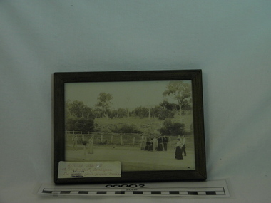
Framed Photo, The Bramley girls playing tennis at the Needles, Berringama, September 20th, 1902, Photograph taken 20th September, 1902
Photograph of Bramley family. Early residents of the Needles, Berringama, Victoria - 20th September, 1902Framed photograph of the Bramley girls playing tennis at the Needles, Berringama, Upper Murray. On back of frame - September 20th, 1902, at "The Needles" Berringama. Charles Bramley and sisters Minnie & Nellie - "The Bramley girls playing tennis."bramley, needles, berringama, tennis -
 Clunes Museum
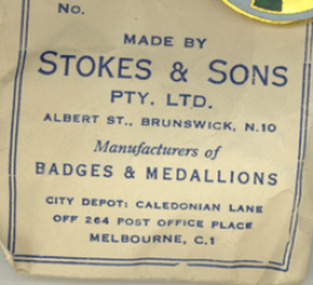
Memorabilia - NUMISMATICS, Stokes & Sons
.1 White metal medal with a tricolour ribbon of red, white and blue. Attached to a ring connected to the medal. One side depicts the scene of landing at Portland in 1834 and the other side depicts a pioneer on the south bank of the Yarra river looking across Melbourne. On Reverse: Centenary of Victoria 1934 and Portland 1834 On Obverse: Centenary of Melbourne 1935 (AD)centenary of victoria 1934, centenary of melbourne 1935