Showing 11221 items matching " planning"
-
 Glenelg Shire Council Cultural Collection
Plan - Ship Plan / Mould, n.d
Wooden pattern for mould for boat fittings. Rectangular, two cylinders of different diameters, one on top of the other, attached. Painted yellow/orange, underside white. -
 Greensborough Historical Society
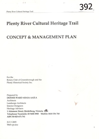
Report, Plenty River Cultural Heritage Trail : Concept & management plan, 2005_07
Prepared for the Rotary Club of Greensborough and Plenty Historical Society by Dennis Ward, this report outlines the heritage importance of the Plenty River Trail around Greensborough.This is an ongoing project by Dennis Ward. This report is an early version of the 2011 Squatters, speculators and settlers: Plenty River Cultural heritage trail. (Item 258) 66 page report, Illus, (some col.) , maps. In red 2-ring binder.Some handwritten notes in last pages.plenty river cultural heritage trail, dennis ward, rotary club of greensborough, plenty historical society, plenty river -
 4th/19th Prince of Wales's Light Horse Regiment Unit History Room
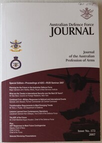
Journal, Department of Defence, Australian Defence Force Journal Issue 173, 2007, 2007
Special edition of ADF Journal reporting the proceedings of joint Australian Defence College - Royal United Services Institute seminar conducted in May 2007ISSN 1320-2545defence planning, conferences, rusi, australian defence college, defence planning, conferences, rusi, australian defence college -
 Kiewa Valley Historical Society
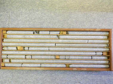
Core Rock Samples
The core samples in the display cabinet were obtained from the various sites at which drilling into the rock surface was carried out (under the control of design and structural engineers of the SEC Kiewa Hydro Scheme - late 1940's). This function was a precursor to the decision where to locate, in this case, the McKay Creek Power Station. The information gained by structural engineers from the core samples would be used also for the placements of underground tunnels entry and exit points and the overall effective size of the generator plant. This would have included drill and blast techniques (rock characteristics play an import part of explosion control), requirements for support structures and reinforcing cement/steel forms. The use and replenishment of diamond drill bits(the strongest available, see KVHS 0280) was dependent on the "type" of rock found (harder rock required greater numbers of drill bits). Support beams for reinforced ceilings and floors was also a necessity.These rock core samples are very significant in the formulation and placement of the underground Power Stations and their maze of tunnels (in and out) for a successful implementation of the Hydro Scheme. The amount of pre-planning and engineering studies required for such a large scheme must be undertaken to ensure that a "white elephant" was not the result.There are nine columns of rock cores, each 30mm in diameter, set in a wooden display rack. A clear plastic (slide out) protective panel is installed to the front section. Within each column are block details of the depth from which that section was brought from. See KVHS for the appropriate sketch details.Depth levels (retrieved from) are shown for each section on wooden Blocks: 1st Block: "7'10" (seven feet, ten inches), 2nd Block:"9'4" (nine feet, four inches), 3rd Block: "19'3" (nineteen feet, three inches), 4th Block: "24'2" (twenty four feet, two inches), 5th Block: "25'7"( twenty five feet, seven inches) and last block: "30' (thirty feet)"alternate energy supplies, alpine feasibility studies temperature, rainfall, sec, kiewa hydro scheme, electricity -
 Kiewa Valley Historical Society
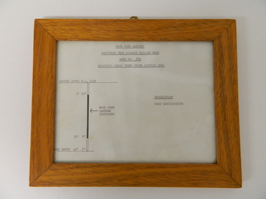
Sketch Rock Core Display, circa mid to late 1900's
This framed sketch details, in graphic form, where the core samples in the display cabinet were removed. The drilling was a precursor to the decision where to locate, in this case, the McKay Creek Power Station. The information gained by structural engineers from the core samples would be used also for the placements of underground tunnels entry and exit points and the overall effective size of the plant. This would have included drill and blast techniques(rock characteristics play an import part of explosion control), requirements for support structures and reinforcing cement/steel forms. The use and replenishment of diamond drill bits(the strongest available, see KVHS 0280) was dependent on the "type" of rock found. Support beams for reinforced ceilings and floors was also a necessity.The visual derails of where the rock core samples were removed is very significant in the formulation and placement of the underground Power Stations and their maze of tunnels(in and out) for a successful implementation of the Hydro Scheme. The amount of pre-planning and scientific studies required for such a large scheme must be undertaken to ensure that a "white elephant" was not the result.This framed and glass front rock core display sketch has type written information of the rock samples displayed in KVHS 0279 (A). It has a softwood stained and glossed frame with a fixed(nailed) back board and a brass fixture for mounting onto a wall.The paper and type are slighted faded (sunlight affected). The sign heading "ROCK CORE SAMPLES RECOVERED FROM DIAMOND DRILLED BORE" underneath this "BORE NO: 883" and below this "LOCATION: McKAY CREEK POWER STATION AREA" to the left a sketch incorporating the ground level point "GROUND LEVEL R.L.3493", and the core depth point "CORE DEPTH 40' 7". In between and representing( in visual form) the core location areain question.alternate energy supplies, alpine feasibility studies temperature, rainfall, sec, kiewa hydro scheme, electricity -
Kiewa Valley Historical Society
Meteorological Conditions - Bogong High Plains
The amount of rain and snow during the year and over the years was recorded regularly. This was done at several sites and was important for the building of the Kiewa Hydro Electric Scheme which involved dams, power stations and racelines.The KHES depended on accurate and detailed measurements of rain and snow on the Bogong High Plains in order to plan and construct high functioning infrastructure. Photocopy of pages re the Meteorological conditions on the Bogong High Plains including the decades from the 1930s to 1980s. Snow depths are also documented.kiewa hydro electric scheme, meteorological conditions on the bogong high plains, snow depth on the bogong high plains -
 Kiewa Valley Historical Society
Book - Alpine Resorts - 2020 draft strategy, Alpine Resorts 2020 draft strategy
This is a commissioned report auspiced by the State Government of Victoria - Department of Sustainability and Environment 2003.This report was prepared to guide the sustainable long-term planning and management of Victoria's six Alpine Resorts. Falls Creek, Lake Mountain, Mount Baw Baw, Mount Buller, Mount Hotham and Mount Stirling, after the catastrophic bush fires of 2002- 2003.Colorured cardboard front cover with two people on air mattresses in foreground. Title white on bue top left corner. 40 glossy thick paper/card pages. A4Logo "Victoria / The Place to betourism in alpine resorts, sustainability and environment, victorian government, 2002-2003 bushfires -
 Kiewa Valley Historical Society
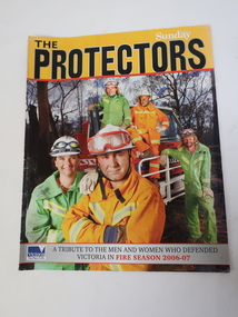
Magazine - The Protectors, A Tribute to the Men and Women who Defended Victoria in Fire Season 2006-07
The magazine covers details of the 2006-07 bushfires in Victoria. On page 31 Region 24 list includes towns in the Kiewa Valley. The Kiewa Valley is under constant threat of bush fires during summer. Local fire brigades assist in the protection of residents.The Kiewa Valley was affected by the 2006-07 bushfires. Residents are encouraged to have a fire plan, to be knowledgeable about bush fires and to be ready to leave their homes when under threat. The local towns each have a fire brigade which includes volunteers. On page 18, 'The Yellow Line" - Photo of Kiewa Valley (Mt Beauty and Tawonga) Crews.Glossy coloured photograph of firemen on the front cover and raging fire on the back cover. 31 pages2006 - 2007 bushfires, kiewa valley fire crews -
 Kiewa Valley Historical Society
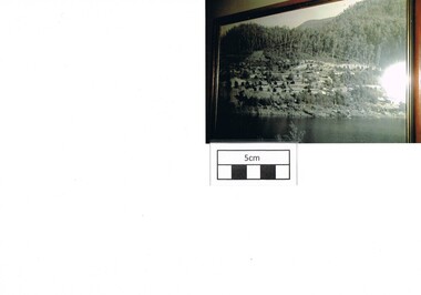
Photograph Bogong, Bogong Township Circa 1950, circa 1940s to 1950s
The Bogong Village was originally constructed (1937-1940) by the State Electricity Commission to house, engineers and construction workers working on the Kiewa Hydroelectric Scheme. These workers were initially settled in 26 houses and were mainly of European heritage. At the completion of the scheme, in the 1960's, the village was opened to public/tourism use. This photograph shows the village before beautification for tourism was introduced and "bare bones" homes and village usage existed.This photo clearly presents a period of restricted human occupation of a very fragile Alpine environment(up to 4000 workmen involved). This was the beginning of a planned and controlled form of sustainable tourist orientated development of the Victorian Alps and high plains region. The Bogong Township was the base camp for workers employed by the State Electricity Commission. After the construction phase was completed, the planning and controls originating from this period have been modified to allow a greater public access of this unique environment.Photograph of a framed glass enclosed black and white photograph of the Bogong settlement Paper details "KodakXtraLife paper" on back of photo. bogong village, bogong township, sec alpine constructions, hydro, kiewa scheme -
 Kiewa Valley Historical Society
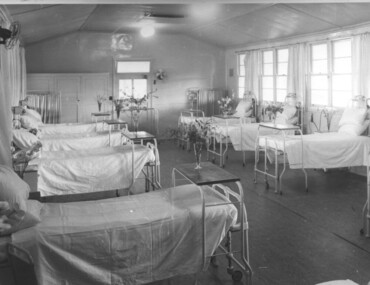
Photograph Tawonga Hospital, A ward at Tawonga Hospital, 1949/50
This photo is of a ward - probably the female ward, as there a many floral arrangements - of the original hospital at Tawonga. This was situated at the corner of Ryders Lane and Kiewa Valley Highway. The building was transported from Bonegilla where it was originally a part of the Bonegilla Military Hospital. The hospital was opened on 24th September, 1949 with a capacity of 12 beds, but was later increased to 35 beds by enclosing the verandahs on 3 sides of the building. 'Add ons' provided theatre, offices, stores and a nurses home. Construction was commenced by the Hospital and Charities Commission with considerable input from the S.E.C., providing the removal and re-erection of the building, the accommodation for nursing staff and carried all work necessary to make the building operational as a hospital. Up until this time the nearest hospital was at Yackandandah. The hospital remained on this site until 1961 when a larger, more suitable building was purchased in Mt. Beauty from the S.E.C.A photographic record of a typical open plan style ward in that era. There were no private rooms. There are portable screens stored at the end of the room to provide "privacy" at the bedside when needed. There is a fan on the wall for cooling. Depicts the rather primitive conditions of that era when compared with todays standards.Black and white photograph of a ward in the Tawonga District Hospitalhospital, ward, tawonga -
 Kiewa Valley Historical Society
Book - Non Fiction History, The Kiewa Story, circa 1993
This book provides in chronological order the development of the Kiewa Hydro-electricity scheme from the first concept (1911) to final construction work (1961). It covers the first attempt to utilise the power of the Victorian Alps water system. It started from a private syndicate and developed to the current State Electricity Commission of Victoria. The incentive for the Hydro scheme was to make money and not as an alternative to the carbon producing coal fired power plants. These coal fired power plants were increasing in numbers to service an ever increasing demand made by population expansion, especially in cities and large rural settlements. This demand spiraled up after World War II when there was a tremendous spike in immigration numbers due to refugees and displaced persons in Europe. The ability to utilise the untapped water provided by the winter snow fields, for a higher yield in electricity, was a powerful incentive to overcome the physical hardships in this remote Alpine region. Future power requirements may initiate the re-installation of the other two power stations(Pretty Valley and Big Hill) covered in original Scheme. This publication not only covers the development of the Kiewa Valley region with respect to population (within a socio-economical framework) but also the subtle but yet strong physical changes of a relatively pristine alpine region. The demands that an ever growing regional population places on the environment is clearly documented in print and black and white photographs. The working and living conditions of those who constructed and gave life to this hydro scheme is well documented in this book. It may be viewed as spartan now but was relevantly good at that moment in time, especially for those workers fleeing a devastated European environment. The successful planning and consideration to minimising any intrusion upon the natural alpine forests and high plains can viewed as an example (compared to the Tasmanian Hydro schemes) of how future hydro schemes (an inevitable requirement) will proceed. Most rural towns (in the early 1900s) were built by unencumbered rural based citizens, with the exception of Mount Beauty and Falls Creek. These two settlements were brought into life by a State (Victorian) Authority for a specific function and program. They were a gated community, that is, only open to construction workers involved with the hydro scheme. All facilities within these communities were provided by the State Electricity Commission of Victoria. The impact on the social, financial and individual independency of the community, by the transition from the S.E.C .environment to one of local government (Shire of Bright), had in some cases a severe impact.This hard covered book has a green cover with pictures on the front and back covers. The front cover has a coloured picture of a snow covered Mount Bogong taken from the opposite mountain range. The valley between both ranges has a whisk of mist over it. At the bottom of this picture are three black and white photographs covering the construction of the Kiewa Hydro - Electricity Scheme. On the back cover is a photograph, (black and white) detailing the Bogong village and Junction dam containing lake Guy. The inside front cover is a black and white photograph which details the construction of the West Kiewa tailrace tunnel during April 1951. The inside back cover is a black and white photograph of the concrete pour at the Clover Dam circa 1952. All photographs and sketches are in black and white. The pages are approximately 160 g/m2 and those which have photographs are on gloss paper.Book spine: "The Kiewa Story Graham Napier Geoff Easdown" alongside this is a white framed circle with white spokes radiating out and underneath in white lettering SECkiewa valley, hydro scheme, victorian alpine region, electricity generators, graham napier, geoff easdown -
 Eltham District Historical Society Inc
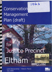
Book, Ivar Nelsen, Conservation Management Plan (draft) for Justice Precinct Eltham (July 2005) prepared for Nillumbik Shire, 2006
Draft for report on guidance on the heritage issues in the management of the court house and former police buildings of the early justice precinct at Eltham.39 p, 30 cm.Harry Gilham E.D.H.S. Inc.eltham justice precinct, justice precinct eltham -
 Warrnambool and District Historical Society Inc.
Book, Description & plans of title & grants
This book contains certificates of title and Crown grants which record local changes of ownership.many are in the township of Warrnambool while others relate to areas such as Nullawarre, Purnim and Framlingham. These documents come under the Transfer of lands act of 1890.The significance of this book lies in the many names and the land to which they were connected. Deep maroon paper over card cover with dark green fabric binding.Alphabetical index at the front followed by 200 pages which record details of the Certificates of title and Crown Grants from around the period of warrnambool, warrnambool history, certificate of title, crown grant warrnambool -
 Warrnambool and District Historical Society Inc.
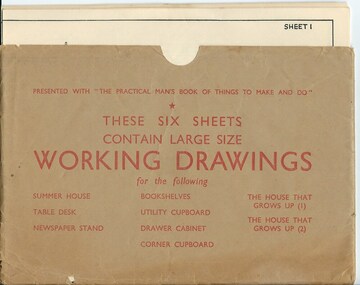
Drawing, Working Drawing House & Furniture Making
These sheets were issued with the book ‘The Practical Man’s Book of Things to Make and Do’ published in the 1950s by the Sun News-Pictorial newspaper. The authors were James Wheeler and W. Shum. The sheets provide simple drawings as a guide to making house additions (Summer House etc) and furniture (table desk, newspaper stand, book shelves, utility cupboard, drawer cabinet, corner cupboard). They were intended to be used by the home handyman. These sheets are of no particular historicalinterest but may be useful for display. They are a good example of the plans and information available to home handymen in the 1950s.These are six cream-coloured sheets of paper containing working drawings for making furniture and house additions. The drawings are printed in black and the headings and measurements are also in black print. The six sheets are enclosed in a brown paper folder which is somewhat creased and a little torn. the practical man’s book of things to make and do, home carpentry, warrnambool, history -
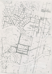
 Eltham District Historical Society Inc
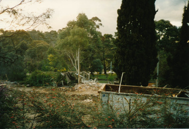
Photograph, Demolition of Eltham Sire Offices, 895 Main Road, Eltham, August 1996, Aug 1996
Two colour photographic prints Originally located in a small pink (with decorative flowers) album, suede spine, 18 x 18 x 6 cm, 50 pages/inserts, 100 photo capacitydemolition, eltham shire office, planning permit -
 Eltham District Historical Society Inc
Document, 14 Stokes Place, Eltham: Building plans and contracts, 1979c
14 Stokes Place was the home of Peter and Carla Vermey. The land was purchased in May 1979 and the home built by Peter and Carla Vermey after the developer, Macquarie Builders went bankrupt. Sold October 2017 by Morrison and Kleeman Real Estate. Stokes Place was part of the Stokes Orchard Estate which was developed from the break-up of the the orchard owned by Frank Stokes who lived on the northeast corner of Nyora Road and Eucalyptus Road. His daughter Beryl advised that the Shire had levied a rate assessment on individual parcels of land within the orchard which became unaffordable resulting in its sub-division and sell off. The Stokes Orchard Estate was developed by Macquarie Builders in two stages starting with stage 1 in 1976. Stokes Place was part of Stage 2 in 1979. The Estate was bounded between Nyora Road, Eucalyptus Road, Diosma Road and Stokes Place. The original orchard only just reached the left most portions of Stokes Place and did not go fully up to Diosma, rather to just beyond the extant of Stokes Place. Stokes Place was known within the family as "The Oats" as that is where they grew oats. Frank Stokes moved to Eltham c.1945 after visiting Harold Bird to view his orchard, located diagonally opposite Stokes Orchard from the intersection of Eucalyptus Road, Pitt Street and Nyora Road. It was on Harold Bird's recommendation that Frank purchased the land.The Stokes Orchard Estate collection is typical of housing developments of the late 1970s and 1980s. It was one of the earliest estates in Eltham following the nearby Woodridge Estate development.Digital file30 digital files scanned from documents provided on loan by Peter and Carla Vermeystokes place, eltham, stokes orchard, stokes orchard estate, streets, houses, peter and carla vermey -
 Eltham District Historical Society Inc
Document, Objection by P. and C. Vermey to Application Ref. No. E94/306 - proposed subdivision Melbourne Water Reservoir & Pumping Station - Diosma Road, Eltham, 1 September 1994, 1/9/1994
The Stokes Orchard Estate collection is typical of housing developments of the late 1970s and 1980s. It was one of the earliest estates in Eltham following the nearby Woodridge Estate development.A4 letter and five accompanying supporting pagesAs notedstokes place, eltham, stokes orchard, stokes orchard estate, streets, houses, peter and carla vermey, diosma road, letter of objection, melbourne metropolitan board of works, planning application, reservoir, shire of eltham -
 Eltham District Historical Society Inc
Document, Notice of Decision to Grant a Permit; Ref: E94/306 - Subdivision of 30-34 Diosma Road; 16 November 1994, 16/11/1994
This permit was eventually overturned following community objection and the land was donated by Yarra Valley Water for use as a community reserve.The Stokes Orchard Estate collection is typical of housing developments of the late 1970s and 1980s. It was one of the earliest estates in Eltham following the nearby Woodridge Estate development.A4 document consisting of ten pagesAs notedstokes place, eltham, stokes orchard, stokes orchard estate, streets, houses, peter and carla vermey, diosma road, letter of objection, melbourne metropolitan board of works, planning application, reservoir, shire of eltham -
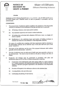
 Eltham District Historical Society Inc
Document, Advertised Development Plan 424/2017/03P for 28 Luck Street, Eltham by R.P. Home Developments Pty Ltd, 29 January 2018
Former Eltham Specialist Centre Nillumbik Shire Council Advertised Application; 9 of 10 pages sourced from Eltham Community Action Group Facebook page, 21 March 2018 Buildings and works to construct (6) six dwellings and reduction of car parking requirements by not providing one visitor car space Digital image (9)eltham, eltham specialist centre, luck street, bible street, r.p. home developments pty ltd, streets -
 Eltham District Historical Society Inc
Photograph, Peter Bassett-Smith, 1852 Plan of Little Eltham and Land Purchase by Josiah Holloway, 1988
Bicentennial/Heritage Week Display, "The Eltham Tradition", Eltham Shire Office, 17-22 April 1988 Colour photographactivities, eltham shire office, heritage display, heritage week, josiah holloway, little eltham -
 Ringwood and District Historical Society
Map, Department of Mines, Plan of area applied for under the mining leases regulations in the township of Ringwood between Maroondah Highway and Mt. Dandenong Road. Mining District of Castlemaine, County of Mornington, Parish of Ringwood T Area 58(A) 2 (R)15(P) Acres, Roods, Perches. 1934, 20-Feb-34
Map of the township of Ringwood with subdivisions between Maroondah Highway and Mt. Dandenong Road. the area applied for on lease No.8210 by E.G.Browne.Mining District of Castlemaine, County of Mornington, Parish of Ringwood T Area 58(A) 2 (R)15(P) Acres, Roods, Perches.Buff coloured sheet foolscap with black printing showing map of the township of Ringwood between Maroondah Highway and Mt. Dandenong Road. Mining District of Castlemaine, County of Mornington, Parish of Ringwood T Area 58(A) 2 (R)15(P) Acres, Roods, Perches +Additional Keywords: Browne E.G. -
Ringwood and District Historical Society
Legal record - Conditions of Sale (C.E. Carter), Bayswater - Lot 10 on Plan of Subdivision No.8305 ,Title 4848 Folio 969462. Frederick Hobbs to Flora Christina Bates
Particulars and Conditions of Sale, from Frederick Hobbs to Flora Christina Bates dated 28th May 1929. -
Ringwood and District Historical Society
Legal record - Conditions of Sale (C.E.Carter), Ringwood - Lot 11, Plan of Subdivision No 6753, M Somerville to M Perkins - 1929
Particulars and Conditions of Sale of Property , from Mary Somerville to Maria Perkins. -
Ringwood and District Historical Society
Legal record - Conditions of Sale (C.E.Carter), Heathmont - Lots 22 & 23, Plan of Subdivision No 2436814, H Gerlach to W H Saunders - 1929
Particulars and Conditions of Sale of Property , from Herman Gerlach to William Henry Saunders. -
Ringwood and District Historical Society
Legal record - Conditions of Sale (C.E.Carter), Ringwood - Lots 22 & 23, Plan of Subdivision No 7112, M Williams to F W Taylor - 1927
Particulars and Conditions of Sale of Property , from Matilda Williams to Frank William Taylor -
Ringwood and District Historical Society
Legal record - Conditions of Sale (C.E.Carter), Ringwood - Lot 9, Plan of Subdivision No 8221, Somerville to Wilkinson - 1923
Particulars and Conditions of Sale of Property , from Robert Somerville to Edith Wilkinson -
Ringwood and District Historical Society
Legal record - Conditions of Sale (C.E.Carter), Ringwood - Lot 27, Plan of Subdivision No 8198, F Dark to E I Barncu(?), 1925
Particulars and Conditions of Sale of Property , from Fred Dark to E.I.Barncu(?) -
Ringwood and District Historical Society
Legal record - Conditions of Sale (C.E.Carter), Ringwood - Lot 56, Plan of Subdivision No 8198, A Wigley to F Dark, 1925
Particulars and Conditions of Sale of Property , from A Wigley to F Dark -
Ringwood and District Historical Society
Legal record - Conditions of Sale (C.E.Carter), Box Hill - Lots 110, 111, 112 & part of Lot 113, Plan of Subdivision No 1879, National Trustees Executors & Agency Company of Australasia Limited ( Executor of Estate of R.E.Ward) to Unstated Purchaser, 1931
Particulars and Conditions of Sale of Property , from Estate of R.E.Ward to Unstated -
Ringwood and District Historical Society
Legal record - Conditions of Sale (C.E.Carter), Ringwood - Lots 3 & 4, Plan of Subdivision No 9626, F H Kennedy to E A & S G Wright - Circa 1920's
Particulars and Conditions of Sale of Property , from Frances Henrietta Kennedy to Edith Ada Wright & Stanton George Wright