Showing 2776 items
matching white horse
-
 Marysville & District Historical Society
Photograph (Item) - Black and white photograph, Fernshaw, c1900
An early black and white photograph taken at Fernshaw.An early black and white photograph taken at Fernshaw. Fernshaw was a rural township 63 km north-east of Melbourne and 10 km north-east of Healesville. Situated on the Watts River, near where a log had fallen making a convenient crossing, Fernshaw was settled in the 1860s. It provided good country for orchards and berry growing. The location was at the foot of Blacks Spur, with Mounts Juliet and Mondah rising on either side, providing spectacular scenery. There were nearby fern gullies giving rise to the name – ‘shaw’ is old English for thicket or wood. By 1875 Fernshaw had a post office (1865), two hotels, a school (1871) and stores. It was famed for its beauty, attracting tourists. In 1886 the Melbourne and Metropolitan Board of Works began work on the Watts River water catchment scheme – later to become Maroondah – and the Board obtained approval for the catchment country to be reserved and kept free of settlement. This required the removal of the Fernshaw township, which was completed by about 1890. The area was described in the 1903 Australian handbook:ARMSTRONG COLLECTION 42 STATION STREET/ SANDRINGHAM 3191/ TEL. (03) 9521 5442/ IAN M.L. ARMSTRONG OAMfernshaw, healesville, watts river, orchard, berry orchard, blacks spur, black spur, mount juliet, mount mondah, maroondah dam, victoria -
 Marysville & District Historical Society
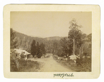
Photograph (Item) - Black and white photograph, Marysville, c1900
An early black and white photograph of the main road in Marysville in Victoria showing the Keppels Australian Hotel.An early black and white photograph of the main road in Marysville in Victoria showing the Keppels Australian Hotel which was built and opened by the Keppel Family in 1865. The Keppels Australian Hotel was the first hotel to be opened in Marysville. The Keppel Family were among Marysville's earliest pioneering families.ARMSTRONG COLLECTION 42 STATION STREET/ SANDRINGHAM 3191/ TEL. (03) 9521 5442/ IAN M.L. ARMSTRONG OAMaustralian hotel, marysville, keppel family, maurice john keppel, keppels australian hotel, keppels hotel, victoria -
 Marysville & District Historical Society
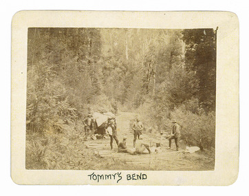
Photograph (Item) - Black and white photograph, Tommy's Bend, c1900
An early black and white photograph taken at Tommy's Bend near Marysville in Victoria.An early black and white photograph taken at Tommy's Bend near Marysville in Victoria. Tommy's Bend is a stretch of road 10 kilometres from Marysville on the Woods Point Road up to Lake Mountain. This road was originally constructed as a corduroy road (or log road) is a type of road or timber trackway made by placing logs, perpendicular to the direction of the road over a low or swampy area. The result is an improvement over impassable mud or dirt roads, yet rough in the best of conditions and a hazard to horses due to shifting loose logs.ARMSTRONG COLLECTION 42 STATION STREET/ SANDRINGHAM 3191/ TEL. (03) 9521 5442/ IAN M.L. ARMSTRONG OAMtommy's bend, marysville, victoria, marysville-wood's point road, corduroy road -
 Marysville & District Historical Society
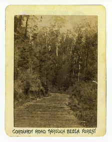
Photograph (Item) - Black and white photograph, Corduroy Road Through Beech Forest, c1900
An early black and white photograph of a corduroy road running through the forest near Marysville in Victoria.An early black and white photograph of a corduroy road running through the forest near Marysville in Victoria. A corduroy road (or log road) is a type of road or timber trackway made by placing logs, perpendicular to the direction of the road over a low or swampy area. The result is an improvement over impassable mud or dirt roads, yet rough in the best of conditions and a hazard to horses due to shifting loose logs.ARMSTRONG COLLECTION 42 STATION STREET/ SANDRINGHAM 3191/ TEL. (03) 9521 5442/ IAN M.L. ARMSTRONG OAMcorduroy road, marysville, victoria, beech forest -
 Marysville & District Historical Society
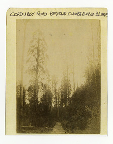
Photograph (Item) - Black and white photograph, Corduroy Road Beyond Cumberland Bridge, c1900
An early black and white photograph of a corduroy road running through the forest near Marysville in Victoria.An early black and white photograph of a corduroy road running through the forest near Marysville in Victoria. A corduroy road (or log road) is a type of road or timber trackway made by placing logs, perpendicular to the direction of the road over a low or swampy area. The result is an improvement over impassable mud or dirt roads, yet rough in the best of conditions and a hazard to horses due to shifting loose logs.ARMSTRONG COLLECTION 42 STATION STREET/ SANDRINGHAM 3191/ TEL. (03) 9521 5442/ IAN M.L. ARMSTRONG OAMcorduroy road, marysville, victoria -
 Marysville & District Historical Society
Photograph (Item) - Black and white photograph, Yarra Track Hotel, c1900
An early black and white photograph of a hotel along the Yarra Track.An early black and white photograph of a hotel along the Yarra Track. The Yarra Track is the former name of the gold fields road from Healesville to the Woods Point and Jordan Goldfields, in Victoria, Australia. A direct route via the Yarra River and the Great Divide was discovered by Rieck in September 1862 and became known as the Yarra Track. Early in 1863, the Victorian Government decided to construct a 193-kilometre (120 mile) road along the route. Its original width varied between 4 and 6 metres (12 and 20 feet), and was designed to accommodate horse-drawn vehicles. The Track involved the climbing of the Black Spur, descent into the Acheron Valley, and then through Marysville to the Cumberland where it followed the existing route. Unable to ascertain both the location and name of hotel.ARMSTRONG COLLECTION 42 STATION STREET/ SANDRINGHAM 3191/ TEL. (03) 9521 5442/ IAN M.L. ARMSTRONG OAMyarra track, healesville, wood's point, jordan goldfields, victoria, yarra river, great divide, reick, black spur, acheron valley, marysville, cumberland creek -
 Marysville & District Historical Society
Photograph (Item) - Black and white photograph, The "Scandinavians' - (Deserted), c1900
An early black and white photograph of The Scandinavian's Hotel and Boarding House along the Yarra Track.An early black and white photograph of The Scandinavian's Hotel and Boarding House along the Yarra Track. The Yarra Track is the former name of the gold fields road from Healesville to the Woods Point and Jordan Goldfields, in Victoria, Australia. A direct route via the Yarra River and the Great Divide was discovered by Rieck in September 1862 and became known as the Yarra Track. Early in 1863, the Victorian Government decided to construct a 193-kilometre (120 mile) road along the route. Its original width varied between 4 and 6 metres (12 and 20 feet), and was designed to accommodate horse-drawn vehicles. The Track involved the climbing of the Black Spur, descent into the Acheron Valley, and then through Marysville to the Cumberland where it followed the existing route.ARMSTRONG COLLECTION 42 STATION STREET/ SANDRINGHAM 3191/ TEL. (03) 9521 5442/ IAN M.L. ARMSTRONG OAMthe scandinavians', yarra track, healesville, wood's point, jordan goldfields, victoria, yarra river, great divide, reick, black spur, acheron valley, marysville, cumberland creek -
 Marysville & District Historical Society
Photograph (Item) - Black and white photograph, Camp Opposite The "Scandinavians', c1900
An early black and white photograph of a camp which was opposite The Scandinavian's Hotel and Boarding House along the Yarra Track.An early black and white photograph of a camp which was opposite The Scandinavian's Hotel and Boarding House along the Yarra Track. The Yarra Track is the former name of the gold fields road from Healesville to the Woods Point and Jordan Goldfields, in Victoria, Australia. A direct route via the Yarra River and the Great Divide was discovered by Rieck in September 1862 and became known as the Yarra Track. Early in 1863, the Victorian Government decided to construct a 193-kilometre (120 mile) road along the route. Its original width varied between 4 and 6 metres (12 and 20 feet), and was designed to accommodate horse-drawn vehicles. The Track involved the climbing of the Black Spur, descent into the Acheron Valley, and then through Marysville to the Cumberland where it followed the existing route.ARMSTRONG COLLECTION 42 STATION STREET/ SANDRINGHAM 3191/ TEL. (03) 9521 5442/ IAN M.L. ARMSTRONG OAMthe scandinavians', yarra track, healesville, wood's point, jordan goldfields, victoria, yarra river, great divide, reick, black spur, acheron valley, marysville, cumberland creek -
 Marysville & District Historical Society
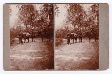
Photograph (Item) - Black and white bi-focal image, Unknown
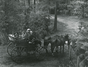
An early black and white bi-focal image of men and packhorses on the Marysville-Wood's Point Road in Marysville in Victoria.An early black and white bi-focal image of men and packhorses on the Marysville-Wood's Point Road in Marysville in Victoria. This is now known as the Marysville-Wood's Point Road. The Marysville-Woods Point Road was originally part of the Yarra Track, constructed in the early 1860s to provide access between Healesville and the Woods Point Goldfields. Despite the steep terrain and engineering difficulties, the Yarra Track soon became a busy route used by pack horses, horse-drawn drays, and wagons. Today this sealed mountain road is a popular scenic drive between Marysville and Warburton.Packhorses on Wood'spoint Road/ Marysville/ Victoriapackhorses, wood's point road, marysville-wood's point road, marysville, victoria, yarra track, healesville, wood's point goldfields, warburton -
 Marysville & District Historical Society
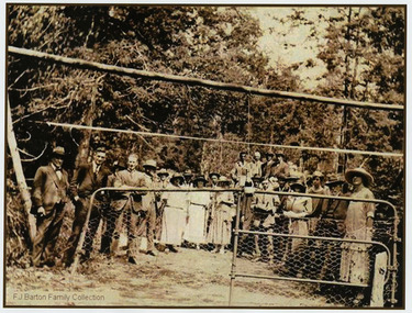
Photograph (Item) - Black and white photograph, 05-02-1924
An early black and white photograph of the ceremonial re-opening of the Marysville-Wood's Point Road in 1924.An early black and white photograph of the ceremonial re-opening of the Marysville-Wood's Point Road in 1924. The Marysville-Woods Point Road was originally part of the Yarra Track, constructed in the early 1860s to provide access between Healesville and the Woods Point Goldfields. Despite the steep terrain and engineering difficulties, the Yarra Track soon became a busy route used by pack horses, horse-drawn drays, and wagons. Today this sealed mountain road is a popular scenic drive between Marysville and Warburton.F.J. Barton Family Collectionmarysville-wood's point road, marysville, wood's point goldfields, healesville, yarra track, warburton -
 Marysville & District Historical Society
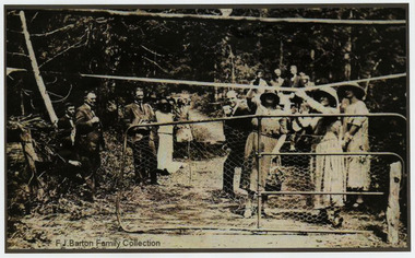
Photograph (Item) - Black and white photograph, 05-02-1924
An early black and white photograph of the ceremonial re-opening of the Marysville-Wood's Point Road in 1924.An early black and white photograph of the ceremonial re-opening of the Marysville-Wood's Point Road in 1924. The Marysville-Woods Point Road was originally part of the Yarra Track, constructed in the early 1860s to provide access between Healesville and the Woods Point Goldfields. Despite the steep terrain and engineering difficulties, the Yarra Track soon became a busy route used by pack horses, horse-drawn drays, and wagons. Today this sealed mountain road is a popular scenic drive between Marysville and Warburton.F.J. Barton Family Collectionmarysville-wood's point road, marysville, wood's point goldfields, healesville, yarra track, warburton -
 Marysville & District Historical Society
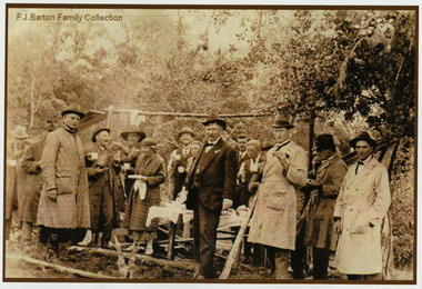
Photograph (Item) - Black and white photograph, 05-02-1924
An early black and white photograph of the ceremonial re-opening of the Marysville-Wood's Point Road in 1924.An early black and white photograph of the ceremonial re-opening of the Marysville-Wood's Point Road in 1924. The Marysville-Woods Point Road was originally part of the Yarra Track, constructed in the early 1860s to provide access between Healesville and the Woods Point Goldfields. Despite the steep terrain and engineering difficulties, the Yarra Track soon became a busy route used by pack horses, horse-drawn drays, and wagons. Today this sealed mountain road is a popular scenic drive between Marysville and Warburton.F.J. Barton Family Collectionmarysville-wood's point road, marysville, wood's point goldfields, healesville, yarra track, warburton -
 Marysville & District Historical Society
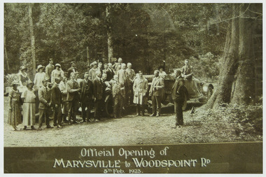
Photograph (Item) - Black and white photograph, Official Opening of MARYSVILLE to WOODSPOINT RD 5th Feb, 1923, 05-02-1924
An early black and white photograph which was taken after the ceremonial re-opening of the Marysville-Wood's Point Road in 1924. The date of 1923 on the photograph is incorrect.An early black and white photograph which was taken after the ceremonial re-opening of the Marysville-Wood's Point Road in 1924. The date of 1923 on the photograph is incorrect. The Marysville-Woods Point Road was originally part of the Yarra Track, constructed in the early 1860s to provide access between Healesville and the Woods Point Goldfields. Despite the steep terrain and engineering difficulties, the Yarra Track soon became a busy route used by pack horses, horse-drawn drays, and wagons. Today this sealed mountain road is a popular scenic drive between Marysville and Warburton.Official Opening of/ MARYSVILLE to WOODSPOINT RD/ 5th Feb, 1923marysville-wood's point road, marysville, wood's point goldfields, healesville, yarra track, warburton, the argus -
 Marysville & District Historical Society
Photograph (Item) - Black and white photograph, Unknown
A black and white photograph taken at the unveiling of the sign placed at The Big Culvert.A black and white photograph taken at the unveiling of the sign placed at The Big Culvert. The Big Culvert is a historic granite and bluestone arch along the Yarra Track, a major route to Melbourne through the 1800s. Built in 1870 and a major piece of infrastructure for its time, the heritage listed culvert allowed water to flow under often-flooded the road. The Yarra Track is the former name of the gold fields road from Healesville to the Woods Point and Jordan Goldfields, in Victoria, Australia. A direct route via the Yarra River and the Great Divide was discovered by Rieck in September 1862 and became known as the Yarra Track. Early in 1863, the Victorian Government decided to construct a 193-kilometre (120 mile) road along the route. Its original width varied between 4 and 6 metres (12 and 20 feet), and was designed to accommodate horse-drawn vehicles. The Track involved the climbing of the Black Spur, descent into the Acheron Valley, and then through Marysville to the Cumberland where it followed the existing route.Unveiling of sign/ at "Big Culvert" In front Max Cockerrell and - Rear: second back Geoff Pope R.H.S. rear: Nancy "/ Anne "the big culvert, yarra track, victoria, healesville, wood's point goldfields, jordan goldfields, black spur, acheron valley, cumberland valley -
 Marysville & District Historical Society
Photograph (Item) - Black and white photograph, John William Lindt, 1910
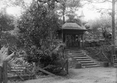
A digital copy of an early black and white photograph of the entrance gate to "The Hermitage" at Narbethong in Victoria.A digital copy of an early black and white photograph of the entrance gate to "The Hermitage" at Narbethong in Victoria. "The Hermitage" was built by photographer John William Lindt as a home and guesthouse in 1894. John Lindt had previously photographed the mountain scenery of the Black Spur and purchased 71 acres and subseqently built his home and guesthouse from where he continued his career. "The Hermitage had a garden designed by John Lindt's friend, Ferdinand von Mueller, who was at one stage the Director of the Melbourne Botanic Gardens. The garden featured New Guinea tree houses from which John Lindt made frequent panoramas of his property and the surrounding forest of towering mountain ash. Aged 81 Lindt died of heart failure during disastrous bushfires on 19 February 1926 at the Hermitage. He was survived by his wife Catherine who continued to run ‘The Hermitage’ guest house before she retired to the city. Visitors to the Hermitage alighted from horse-drawn vehicles and later motor coaches to enter the estate through the lich-gate in the background.the hermitage, john william lindt, narbethong, victoria, black spur, ferdinand von mueller, melbourne botanic gardens, new guinea, catherine lindt -
 Marysville & District Historical Society
Photograph (Item) - Black and white photograph, John William Lindt, 1910
An early black and white photograph taken near the entrance gatehouse to "The Hermitage" at Narbethong in Victoria.An early black and white photograph taken near the entrance gatehouse to "The Hermitage" at Narbethong in Victoria. "The Hermitage" was built by photographer John William Lindt as a home and guesthouse in 1894. John Lindt had previously photographed the mountain scenery of the Black Spur and purchased 71 acres and subseqently built his home and guesthouse from where he continued his career. "The Hermitage had a garden designed by John Lindt's friend, Ferdinand von Mueller, who was at one stage the Director of the Melbourne Botanic Gardens. The garden featured New Guinea tree houses from which John Lindt made frequent panoramas of his property and the surrounding forest of towering mountain ash. Aged 81 Lindt died of heart failure during disastrous bushfires on 19 February 1926 at the Hermitage. He was survived by his wife Catherine who continued to run ‘The Hermitage’ guest house before she retired to the city.the hermitage, john william lindt, narbethong, victoria, black spur, ferdinand von mueller, melbourne botanic gardens, new guinea, catherine lindt -
 Merbein RSL Sub Branch
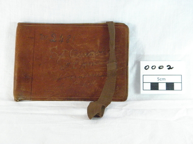
wallet leather, (estimated); World War One
This wallet was donate with a number of other items belonging to Robert James Oscroft.Brown leather wallet thatfolds in the middle,two compartments inside,one for photo,white elastic in fold for notes, brown elastic through slits in the rear of wallet.Inscription on front.Machine sown. inscription on front. "No 2481/Sgt Oscroft R J/12th L'Horse/hard to read/hrd to read/No653world war one, gallipoli, robert james oscroft, 12th light horse, leather wallet, sargent, service number 2481, service number 653 -
 Eltham District Historical Society Inc
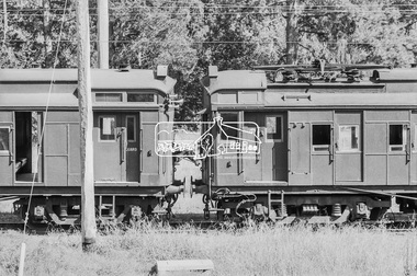
Photograph, George Coop, A Tait (Red Rattler) train in the storage yard at Hurstbridge Railway Station, 7-8 February 1981, 1981
Digital TIFF file Scan of 35mm Ilford FP4 black and white transparencyhorses, hurstbridge line,hurstbridge railway station, red rattler, tait train -
 Eltham District Historical Society Inc
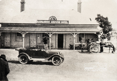
Negative - Photograph, Thornton's Kangaroo Ground Hotel, c.1925
Reproduced on p21 of 'Pioneers & Painters' Mrs. R. Thornton notifies that she has taken over the Kangaroo Ground Hotel from Mr. Walker, and the house will be made attractive for weekenders, the table, wines, and spirits being A1 quality" - Advertiser 7 July, 1922" Mrs Ruby C. Thornton sold her interest in the Kangaroo Ground Hotel in September 1928 and moved away after seven years in the district. This photo is therefore dated between July 1922 and 1928. Other newspaper articles identify Mrs Thornton's first name. The lady to the left of frame appears to be taking a photograph of the car in front of the hotel. This may be Mrs Ruby Thornton taking a picture of her car in front of her hotel. A young boy with others standing near their horse and buggy look on.Roll of medium format 120 6x6 black and white negative film, 3 framesAgfa APX 100kangaroo ground, automobile, kangaroo ground hotel, shire of eltham pioneers photograph collection, thornton, ford model t, horse drawn carriage, mrs ruby thornton, pioneers and painters -
 Glen Eira Historical Society
Document - Animals
This file contains 2 items: 1/A black, white and green brochure titled ‘Leash Free Parks and Reserves’ concerning leashing regulations, conditions for non-leashing, summaries of legislation and penalties for owners of dogs, written by the City of Glen Eira. It includes six illustrations and a map of Glen Eira which labels all leash free parks as well as a depiction of all the train stations in the area. 2/A collection of 37 black and white photographs which have all appeared in Caulfield Contact at some time. These include photographs of the ‘Caulfield Veterinary Clinic, North Road Ormond dated 1982, Animal Control officer Reg Dixon dated 1982, draught horses pulling a horse drawn cart dated 1988 and general animals. Photographs unknown.allnutt park, murrumbeena park, veterinary clinics, professionals, veterinarians, kirschner jane s., north rd. ormond, dixon reg, animal control officer, horses, racehorses, racecourses, draught horses, bailey reserve, sporting grounds, bentleigh/hodgson reserve, boyd park, neerim road, caulfield park, caulfield race course, duncan mackinnon park, ee gunn reserve, glen huntly park, joyce park, king george v1 memorial reserve, lords park, marara road, marlborough street reserve, moorleigh, victory park, princes park, packer park, animal enclosures, domestic animals, dogs, horse drawn vehicles, cattle, birds, animals, trains, caulfield contact -
 Glen Eira Historical Society
Document - Dairies
This file contains six items: 1/Handwritten information from 1874 Sands & McDougalls sent to Mr. P Murray in 26/05/1977 from Miss IV Anderson/ 2/Typed pages from Sands & McDougalls, 1911, 1913, 1942 editions dairy entries. 3/Four separate receipts, one photocopied of local dairies, various dates. 4/Two black-and-white photographs of Archibald Short, proprietor of Shorts Dairy in Carlingford Street, and resided in College Street, Elsternwick. 5/Printed document taken from Purchase Agreement between Clara Benzley and Thomas Jenner, on the purchase of a dairy at 43 Woornack Road. Carnegie 13/08/1926. Gives the items included in contract of sale, including 2 horses. 6/Caulfield Glen Eira Leader newspaper article dated is May, 2014, showing upcoming sale of 43 Woornack Road, Carnegie. The property was Clara Benzley’s (granddaughter Claire Barton) dairy in 1926.burlington model dairy, glen huntly road, caulfield, hall mr., carinya dairy, orrong crescent, bradin, rice l. i., dairyman, green r., queens ave., carnegie, neerim road, parton’s dairy, hawthorn road, short archibald, carlingford street, south caulfield, college street, elsternwick, milk cart, dairying, dairies, land sales, real estate, architectural, woornack road, auctions -
 Glen Eira Historical Society
Document - ROTARY CLUB OF CAULFIELD
This file contains 13 official documents pertaining to the Rotary Club of Caulfield: 1/A typewritten copy of the constitution of the Rotary Club of Caulfield (undated). Said document is essentially an instruction manual detailing how the Club is to be administered and the duties of officials. 2/A page (unclear if intended for use as a poster or letter) announcing a Business Persons Breakfast to be held at St. Anthony’s Parish Hall on 19/11/1986, wherein Jeff Kennett, M.L.A., Leader of the Opposition of the Parliament of Victoria, will deliver a speech titled ‘Responsibility Before Rights’. 3/A booklet announcing the 25th anniversary celebration of the Rotary Club of Caulfield, to be held at Tudor Court on 24/02/1987. Contains the menu, national anthem, programme, and two lists – one of the founding members of the Club and one of the extant members of the Club. 4/Two copies of a booklet announcing a dinner, to be held at Tudor Court on 10/11/1987, wherein charter will be presented to the Rotary Club of Caulfield-Rosstown by District Governor Ian Knight. Contains a list of extant staff, the menu, the programme, a description of the history of the ‘Wembley Wheel of Friendship’, a list of charter members, and an account of the etymology of the name ‘Rosstown’. 5/Two copies of a page featuring four items of relevance to the Rotary Club of Caulfield. The first is an article (titled ‘Rotary scholar makes it’, author unspecified, source unspecified, undated) about Club scion Mark Collard receiving an MBA from Clarkson University. The second is an article (titled ‘New Caulfield Rotary’, author unspecified, source unspecified, undated) about the presentation dinner to which item 7 pertains. (This article is not present in its entirety, trailing off at the end.) The third is an announcement of a ‘progressive dinner’ to be held on 28/11/1987, also containing an announcement of a bicentennial conference to be held on 19/03/1988. The fourth is an announcement of what appears to be the initiation of some sort of historical re-enactment, the proceeds of which will fund the Rotary Club’s ‘Polio Plus’ project. A title (‘A Long Haul Through Caulfield’) suggests this item may be the header section of an article about said event, but if so, the remainder is not present. Contains three black-and-white photographs; one of Collard with an unidentified woman (presumably his wife), one of Club President Howie Dunlop congratulating Charter President Geoff Oscar, and one of some men riding on a horse-drawn cart. 6/Two copies of a booklet announcing a President Changeover Dinner, to be held on 28/06/1988. Contains the menu, programme, and a list of extant members. 7/Two copies of the weekly bulletin of the Rotary Club of Caulfield, dated 28/06/1988. Contains lists of faculty, notification of the Club’s decision to admit women, notification of upcoming events, a biography of guest speaker Fred Epstein, and a list of the times and places of alternative meetings. 8/Two photocopied statements of the receipts and expenditure of the Rotary Club of Caulfield, one for the period 01/10/1989 – 30/06/1990, and one for the period 01/07/1990 – 27/08/1990. 9/The photocopied minutes of a New Members Committee Meeting of the Rotary Club of Caulfield, dated 02/08/1990. Objects of discussion include fundraising methods and application of funds. 10/A booklet announcing Change Over Night, dated 21/06/1994. Contains the programme, menu, national anthem, and a list of extant faculty. 11/4 unbound pages announcing the winners of the Rotary Youth Photographic Awards, dated 1995 (a more specific date than this is not given). (Pages contain no photographs.) 12/A small note announcing the Murrumbeena Community Market, to be held on 04/12/2010, of which the Rotary Club of Caulfield is one of the sponsors. 13/A booklet announcing a dinner to celebrate the 50th anniversary of the Rotary Club of Caulfield, to be held on 23/02/2012. Contains the programme, menu, a list of past presidents, a description of the history of the Gifu Vase (a trophy in the Club’s possession), and a list of some of the charity projects the Club has been engaged in.rotary club of caulfield, clubs and associations, charitable organisations, kennett jeff m.l.a., st. anthony’s parish hall, grange road, neerim road, glenhuntly, festivals and celebrations, tudor court, gray robin, baird jack, lord john, king john, crittenden doug, gelme anthony, hunkin ed. rev., fryer roy, quine john, bedford f., bell jim, bunny d., cripps e., don john, epstein fred, hattam j., howard w., kerry g., kumnick j., kurrie s., lord l., morrison charles, nelson h., parton willis, perry bruce, pollard r., price f., skuse e., stillwell g., tilley norman, tomlinson charles, watson don, webster j., wilson duncan, fincher roy, wheller john, allen selwyn, christopher don, cohen godfrey, davis keith, davis lloyd, dornbierer w., dunlop howie, fillmore wally, ford john, ford peter, forshaw ken, gales brian, green myer, hind jim, humphreys john, hunter ian, lewis ray, melville jack, oscar geoff, penaluna harry, perlen louis, rampling ross, ronaldson keith, sherlock max, sicklemore graham, smith barry, stapleton ted, summers ron, tovey david, rotary club of caulfield-rosstown, knight ian, tudor court, kooyong road, bellmaine mark, langfelder kurt, morris rob, rome graeme, alma club, wilks street, wills david, blankfield mark, awards, wembley wheel of friendship, bellmaine loretta, cunningham david, cunningham jean, davis pam, davis rex, davis judith, forshaw hannah, graham jeremy, graham kara, hassing andre, hassing arlette, jacobs frank, jacobs june, langfelder judy, morris robert, morris angela, nettlebeck rosalie, oscar enid, rattray john, rattray diana, rome lorraine, sarah ted, sarah denise, sherlock helen, smith suzanne, stapleton jackie, turner brook, turner vicki, tuhiwai tamati, tuhiwai ravina, will arnold, will claire, rosstown, ross william murray, rosstown sugar works, collard mark, rotary foundation, keller chuck, campbell felicitie mrs., campbell jack cr., knight genny, albury civic centre, green tess, tantram avenue, quine gwen, beaver street, rosalind ray, rosalind lweis, devon street, little company of mary hospital, polio plus, smith ian, jackson adrian, miller peter, spence bert, wheller denise, coffey bill, financial documents, receipts, gilmartin e., moran d., kaan a., fillmore wal, coleman peter, coleman moyrha, wesley college elsternwick big band, puddy mark, fradkin barry, fitzgerald gerald, renton robert, herschberg gedeon, kinston david, montgomery peter, dawes shane, silberberg henry, zazryn ben, cohen michael, rotary youth photographic awards, photographic competitions, photography, terry ted mr., terry e. a. mr., eldridge hannah, cottral anne, abdullahi khalid, gostin cassie, podlabeniouk lena, diyab ahmed, draca julijana, pevkoski danilla, wooster heath, lesar dion, sansoni rachel, leatham chelsea, townsend jessie, barker megan, fitzgerald megan, maokhamphiou anthony, smith naomi, fraser sue-ellen, white tanya, murrumbeena community market, koornang uniting church, murrumbeena road, welsh heather, robinson david, kesselschmidt sima, potasz sophie, southwick david, cheyne gordon, ryall keith, arianti listy, westbrook natasha, pollard bob, hancock irey, lovett jack, cooper alby, rundle john, patkin nehama, mcmullen adele, douglas jennie, preston mark, resubal loreto, gifu vase, aoki seiichi, operation firewood, alfred hospital, bus of knowledge, australia day breakfast, bethlehem hospital, caulfield hospital -
 Glen Eira Historical Society
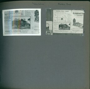
Album - Album page, Glenholme, Bambra Road, Circa 1972
This photograph is part of the Caulfield Historical Album 1972, showing an advertisement for the 21/04/1923 Glenholme Estate sale through real estate agents Knight and Harwood. This album was created in approximately 1972 as part of a project by the Caulfield Historical Society to assist in identifying buildings worthy of preservation. The album is related to a Survey the Caulfield Historical Society developed in collaboration with the National Trust of Australia (Victoria) and Caulfield City Council to identify historic buildings within the City of Caulfield that warranted the protection of a National Trust Classification. Principal photographer thought to be Trevor Hart, member of Caulfield Historical Society. Most photographs were taken between 1966-1972 with a small number of photographs being older and from unknown sources. All photographs are black and white except where stated, with 386 photographs over 198 pages. This polychrome brick and slate-roofed mansion was built by John Hart in 1871. Later owned by James McDougall (partner in Sands and McDougall; director of the first Caulfield horse tram company). Later again, it became a psychiatric hospital; demolished c1923.Page 36 of Photograph Album with two photographs of Glenholme Estate advertisements.Handwritten: "Glenholme" Bambra Road [top] / 36 [bottom right]trevor hart, caulfield north, bambra road, glenholme, advertisements, glenholme estate, knight and harwood, real estate agents, maps, polychrome bricks, slate roofs, john hart, james mcdougall, psychiatric hospitals -
 Glen Eira Historical Society
Album - Album page, Glen Eira Road, Circa 1972
This photograph is part of the Caulfield Historical Album 1972. This album was created in approximately 1972 as part of a project by the Caulfield Historical Society to assist in identifying buildings worthy of preservation. The album is related to a Survey the Caulfield Historical Society developed in collaboration with the National Trust of Australia (Victoria) and Caulfield City Council to identify historic buildings within the City of Caulfield that warranted the protection of a National Trust Classification. Principal photographer thought to be Trevor Hart, member of Caulfield Historical Society. Most photographs were taken between 1966-1972 with a small number of photographs being older and from unknown sources. All photographs are black and white except where stated, with 386 photographs over 198 pages. From Glen Eira Heritage Management Plan 1996 by Andrew Ward: Since 1990, valuable historic houses to have been demolished include "Noris", later "Quethiock", and "Koala" (1875) at 34 Balaclava Road, "Urandaline", later Samford private hospital at 510 Glen Eira Road, and No. 9 Lempriere Avenue. When the Caulfield Tramway Company opened its single line horse tramway along Glen Eira Road to Caulfield station in 1889, the eastern end of this road passed through open paddocks and alongside "Urandaline", a charming late Victorian villa residence with comer pinnacle roof, demolished in 1995.Page 59 of Photograph Album with five photographs, one portrait of the exterior of a house on Glen Eira Road, the other four are photos of sections of advertising materials for Urandaline Estate.Hand written: 508 Glen Eira Road [under top left photo] / 58 [bottom left] trevor hart, glen eira road, caulfield north, urandaline, urandaline estate, horse tram, land subdivision, real estate advertising, verandahs -
 Glen Eira Historical Society
Album - Album page, Booran Road, 30, Circa 1972
This photograph is part of the Caulfield Historical Album 1972. This album was created in approximately 1972 as part of a project by the Caulfield Historical Society to assist in identifying buildings worthy of preservation. The album is related to a Survey the Caulfield Historical Society developed in collaboration with the National Trust of Australia (Victoria) and Caulfield City Council to identify historic buildings within the City of Caulfield that warranted the protection of a National Trust Classification. Principal photographer thought to be Trevor Hart, member of Caulfield Historical Society. Most photographs were taken between 1966-1972 with a small number of photographs being older and from unknown sources. All photographs are black and white except where stated, with 386 photographs over 198 pages. From Glen Eira Heritage Management Plan 1996 by Andrew Ward: In 1888, John Leek, a trainer, owned Lot 15, measuring one and three quarter acres, in Booran Road, north side between Glen Eira and Neerim Roads. The land backed onto the Caulfield Racecourse Reserve. NAV was £45. In 1890 Leek built for his residence, a ten roomed brick house on the site. NAV was £200. Leek was the owner/trainer of "Ingliston" who won the Caulfield Cup in 1900. Upon the horse's death in 1901, Leek is understood to have defied tradition by spending £20 on boots for the "ragged urchins in Bourke Street" instead of "shouting" at the bar. By 1899, the property was owned and occupied by Alfred Merrill, a dentist and was known as "Andover". NA V had decreased to £ll0. By 1910, Leslie Macdonald, a gentleman had purchased the property and renamed it "Moidart". In 1910-11 Macdonald sold it to John Robertson. The property had extensive wood stables on its north-east boundary and several other outbuildings. The house continued to be described as "Brick, ten rooms" as it was in 1926 when it was owned and occupied by John Arthur, a managing director. The land measured la.2r.31p. and had a NAV of £235. Nine people lived there. In 1926, Arthur also owned the adjoining Lot 16. Other racehorses of note, known to have been stabled here include Sobar, Havelock, Proud, Future and Lord.Victorian Heritage Register https://vhd.heritagecouncil.vic.gov.au/places/13532 What is significant? Lord Lodge is a thoroughbred racehorse training complex adjacent to Caulfield Racecourse, established in 1890. The area immediately around the racecourse has been associated with horse racing activities and businesses servicing the industry since the development of the racecourse in late the 19th century. Lord Lodge was named by the present occupants after the champion racehorse Lord who was stabled there in the 1950s. In the early 20th century the property was known as 'Andover' and subsequently 'Moidart'. The site consists of a single storey brick Italianate villa, jockeys' quarters, stables and open day yards with direct access to Caulfield racecourse from the rear of the property. The villa of 10 rooms on bluestone foundations was constructed in 1890 by John Leek, a horse trainer who purchased the newly subdivided land in 1888. The house has many Victorian Italianate or Boom Style features although it is more modest than many villas of its style. It has an asymmetrical facade with a faceted bay window and a prominent central tower with low pitch pyramidal roof that provides a clear view of the racecourse. Other characteristic features include stilted segmented arches, bracketed eaves, stucco wall finish and cast cement ornamentation. A room has been added on the north-facing verandah in sympathetic style and finish. Internally the rooms are substantially intact with original marble fireplaces and intricate ceiling roses and cornices. An entrance toward the rear of the southern side of the house is said to be where the stable hands, jockeys and other staff lined up for their meals. In the southeast corner of the property, backing directly on to Caulfield racecourse, is a substantial late Victorian timber stable, probably constructed in the 1890s but first appearing on the property title in 1910. The stable has 12 stalls, a loft and brick pavement and jerkin head roof form with varnished pine-lined ceiling carried on a chamfered timber frame. It has an original roof lantern. The doors of the stalls are not the original sliding doors but swing doors obtained from a barn at Epsom Racecourse in Mordialloc prior to demolition. Outside the gambrel roof has fretted barges but the building is otherwise utilitarian. Timber throughout the stalls has been worn by chewing and rubbing of horses over the century of its use. In the southern half of the property are open day yards where the racehorses are kept during the day. The red brick, single storey jockeys' quarters to the rear of the villa were probably built around 1950. A small brick, possibly late Victorian structure on the eastern boundary thought to have originally been a gardening shed, has been converted to a stable of two stalls. Modern concrete brick stables fill the northeast portion of the property. At the front of the property two Moreton Bay Figs (Ficus macrophylla), probably planted in the late 19th century, provide shade for horses in the day yards. In the 1890s John Leek sold the property, relocating his training facility to one of the newly established racecourses at Mentone or Mordialloc (Epsom). By 1899, the property was owned and occupied by Alfred Merrill, a dentist, who named the property 'Andover'. In 1910 it was purchased by Leslie McDonald, a gentleman, and renamed 'Moidart'; sold in 1910-1911 to John Robertson; and again in 1926 to John Arthur, a racehorse owner. The Victorian Amateur Turf Club purchased the property in the late 1930s and since this time has been leased to racehorse trainers. It is unclear whether the property operated as a training facility between 1899 - 1926. Several notable trainers and jockeys are associated with Lord Lodge. The best known is Arthur 'Scobie' Breasley, Australia's most successful jockey who was apprenticed to trainer Pat Quinlan at Lord Lodge (then 'Moidart') from 1928 - 1935. Breasley rode winners of the Caulfield Cup in four successive years 1942-45 and again in 1952. John Leek, the original owner of Lord Lodge trained Ingliston, the 1900 Caulfield Cup winner. Along with 'Lord' a number of well known racehorses including Sobar, Havelock, Proud and Future were trained at Lord Lodge .....Page 40 of Photograph Album with three landscape photographs of the exterior of this house.Handwritten: 30 Booran Road [top right hand corner] / 40 [bottom right]trevor hart, jenny o'donnell, booran road, mansion, caulfield east, ingliston, sobar, havelock, proud, future, lord, andover, moidart, lord lodge, grace darling, caulfield racecourse reserve, victorian amateur turf club, historic buildings register, national estate register, caulfield cup, horses, stables, horse racing, racehorses, outbuildings, racehorse trainers, depression, 1890s, brick houses, mansions, towers, verandahs, stained glass, italianate style, victorian style, architectural features, architectural styles, john leek, leslie macdonald, john arthur, john robertson, alfred merrill, jenny odonnell -
 Glen Eira Historical Society
Album - Album page, London Tavern, Hawthorn Road, Circa 1972
This photograph is part of the Caulfield Historical Album 1972. This album was created in approximately 1972 as part of a project by the Caulfield Historical Society to assist in identifying buildings worthy of preservation. The album is related to a Survey the Caulfield Historical Society developed in collaboration with the National Trust of Australia (Victoria) and Caulfield City Council to identify historic buildings within the City of Caulfield that warranted the protection of a National Trust Classification. Principal photographer thought to be Trevor Hart, member of Caulfield Historical Society. Most photographs were taken between 1966-1972 with a small number of photographs being older and from unknown sources. All photographs are black and white except where stated, with 386 photographs over 198 pages. Glen Eira Heritage Management Plan 1996 by Andrew Ward The 1857 rate book indicates that the major portion of the District was under pasture, although a considerable portion was cultivated. There were 159 houses, huts and tents whose occupants were mainly occupied on the land. If "Camden Town" was the principal commercial focus for the District in 1857, it was to remain so in later years, incorporated today in the Glenhuntly Road centre which extends more or less continuously from Elsternwick to Bambra Road. The Caulfield State School of 1877, the horse tramway of 1889 and subsequently the electric trams were all events confirming the importance of Glenhuntly Road and the fledgling community of "Camden Town" wherein the City's commercial centre has its origins. It is recalled, today, by their presence, and also by the "London Tavern" in Hawthorn Road, established by John Guess in 1873. Dr Geulah Solomon's 4 volume book "Caulfield's Heritage" Vol 1 p 93: "A modern hotel presently on the site continues the name of the London Tavern." That was true until recent years as the hotel is named The Camden Hotel now (2021).Page 81 of Photograph Album with one landscape photograph of the front of the London Tavern with handwriting on the edge of the photograph.Hand written: LONDON TAVERN HOTEL 1937 [on bottom edge of photo] / 81 [bottom left] trevor hart, caulfield, hawthorn road, london tavern, camden town, john guess, hotels, pubs, victorian, 1870's, 1930's, sycamore street, the camden hotel -
 Flagstaff Hill Maritime Museum and Village
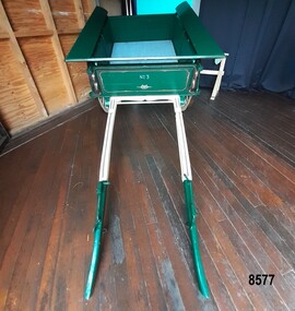
Vehicle - Tip Dray, Prior to 1930s
A Dray is a type of dead axle wagon that was used to transport heavy loads or objects. They had a flat level floor and while some had no sides, others had box bodies and sides. Tip Drays (also known as Tip Carts, Muck Cart, Scotch Cart, Tumbrel or Putt in different parts of England) were smaller than other drays as their loads were heavy and usually only pulled by one horse. Their basic design included two wheels, a tipping body and shafts. The Tip Dray has a unique mechanism that allows the top to tip backwards to tip the load out of the back of the dray. The tipper was activated by a handle at the front allowing the driver to operate it while still having control over the horse. A Tip Dray was an indispensable piece of equipment in the days before tractors and mechanical trucks. They were used by farmers and carters to transport hay, rocks, bricks, gravel and rubbish etc. and because they were useful for dumping loads, they were favoured for use in road and railway construction. A photo in the collection of the Lorne Historical Society shows a tipping dray being used during the construction of the Great Ocean Road. They were part of the daily street traffic in towns and cities around Australia from the early days of settlement. In Australia in the early 1900's, carters began to join unions to protect their jobs and pay. N.S.W. had a "Trolley, Draymen and Carters Union", Queensland had a "Tip Dray Men's Association" and in W. A. the "Top Dray Driver's Union" had a "cessation of work" in 1911 when they were fighting for an increase in their day's wages. In 1910 a meeting of Tip Carters was held in Geelong at the Trades Hall to discuss the formation of a union (The Geelong Tip Dray Carters) which was a success and a schedule of rates for all carting, whether by contract or day labor, was fixed. By 1912 they had "labelled" more than 50 drays and had representatives on the "Trades Hall and Eight Hours Committee". By the mid 1930's and early 1940's, tip drays were being superseded by mechanical trucks and utes. However tip drays continued to be used in some circumstances. They were a practical solution to the problem of petrol rationing during W. W. 2. It was noted in a letter to the editor in the "Sunshine Advocate" in 1938 that a positive argument for continued use of Tip Drays for rubbish collection related to the idea that a horse drawn vehicle involved with lots of stops and starts at different houses (very like a milkman's delivery route) often involved the horse "driving itself" while the driver picked up the rubbish - something a motor truck was unable to do! Another article written in August 1935 and published in the Age in a parliamentary report into the rubber industry noted "tip drays had almost disappeared and in their place, metal was carted in 5 ton motor trucks" but the report went on to say that as a part of the Government relief work (during the Great Depression) the Government had "to some extent reintroduced the tip drays so that a greater number of men would be employed". This particular tip dray was owned by Mr. Oswald (Jack) Bourke. He used it to deliver dry goods from Sunbury to the Queen Victoria Market in Melbourne several times a week in the 1930's and then (between 1945 and 1962) Mr. Bourke used it on the garbage round in Springvale Victoria for the Springvale Council. The Council owned three drays and the "No. 3" painted on this dray is in recognition of its original number. After the death of Mr. Bourke in 1990, one of Mr. Bourke's sons (Andy) found the dray in a shed and restored it. The sign writing on the back and side panels were added during the restoration. This Tipping Dray is a significant example of a horse drawn vehicle that was used by workers from the early days of white settlement through to the 1940's and even into the early 1960's. It was used in a range of "working class" occupations - road construction, railway construction, carting goods, rubbish collection etc. and would have been found in cities, country towns and on farms.A wooden and metal tipping dray with a box body and four sides. It has two iron and wooden wheels (with 14 spokes), two wooden shafts and a metal tipping mechanism. The back panel folds down to allow loads to be dumped out. It is painted in green and cream with sign writing on one of the sides and on the front and back panels. It features decorative painted lines and designs in burgundy, cream and light blue on most of the wooden parts. The tipping mechanism is on the front of the dray's left side and consists of a metal pin secured with a metal ring, and a lever.Front of dray - "No. 3" Side of dray - "A. & M. BOURKE / Contractors / LONGWARRY" Back of dray - "G.T. ANDREWS / QUEEN VICTORIA MARKET - Stand C23 / Phone DANDENONG 225"flagstaff hill maritime museum and village, warrnambool, shipwreck coast, tipping dray, dray, tip dray, tip cart, vehicles, horse drawn vehicle, springvale council, jack bourke, muck cart, scotch cart, tumbrel, putt, box body, oswald bourke, sunbury, queen victoria market, melbourne, no. 3 -
 Flagstaff Hill Maritime Museum and Village
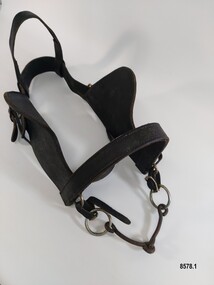
Equipment - Horse Harness, Glenn's Leather Goods, Early to mid-20th century
The early settlers of Victoria depended on horse drawn vehicles to farm, make roads and railways, deliver produce and transport people. Horse harnesses were an important requisite for all drivers and could be found wherever there were working horses. Horse Harnesses have played an essential role in different cultures throughout history. Simple, utilitarian horse harnesses made of leather straps and iron rings were being used in early China before AD 500 as well as ancient Greece and Rome allowing horses to pull chariots and ploughs. The Greeks and Romans were the first to use a "horse collar" which distributed the weight of the harness evenly across the horse's chest rather than relying on a "throat harness" that could damage a horse's throat or choke them. During the medieval period, European horse harnesses became more elaborate and decorative. Variations of different horse harnesses were also found in Native American and Middle Eastern cultures. Horse Harnesses usually have four basic components which include - 1. Communication - the bridle, bit and reins allows the driver to communicate instructions and commands to the horse, guiding its movement and direction. 2. Draft - the collar, hame straps, hames, traces and chains enables the horse to draw and pull the load efficiently by distributing the weight and transferring the pulling force to the vehicle. 3. Stopping - the breeching band, pole straps and breast strap helps to control or stabilise the horse and vehicle when moving downhill or stopping. 4. Support - the back pad, backband, belly band and back saddle keep the harness in the correct position and proper alignment. This dray harness is a plain, basic harness and reflects its working class origins. It was used by Mr. Oswald (Jack) Bourke with his horse and dray to firstly deliver drygoods from Sunbury to Melbourne in the 1930's and later (through the 1940's and 1950's up to 1961) when he worked on the garbage round for the Springvale City Council. This horse harness is a significant example of the equipment that was needed wherever horses were being used - particularly in the early years of Victoria's settlement by white settlers. Harnesses such as this example were used with drays, farming equipment, delivery carts and personal transportation.A leather and metal horse harness used with a horse and dray circa 1930's to the early 1960's. It is made up of a number of components. 1. A leather bridle with metal buckles and rings, blinkers and a metal single jointed, snaffle bit that has the initials M B stamped onto the leather. 2. A leather bridle with metal buckles and rings and a metal "straight bar" Eggbut snaffle bit. It has an elongated X design (with 4 dots) stamped onto the leather strap holders near each buckle. 3. A blue and white vinyl halter with one leather patched strap. The nose band and a chin strap are covered with woollen padding. 4. A pair of leather shaft protectors. They have lacing holes along each edge and a repeating design of small shapes (flowers, wings, crosses and arrowheads) which run along the front of each protector. 5. A leather strap with a stainless steel chain and catch and a maker's mark for "Glenn's Leather Goods, Pearcedale Victoria" stamped onto the end. 6. A wide leather strap covered with a webbing sleeve. It has two large metal rings and each end and one ring has a rope attached. 7. A leather strap comprised of three separate sections (two shorter and one longer) joined with two metal rings. The longer section has notches along its length and the shorter section at the other end has a buckle. It also had a maker's mark stamped on it but the mark is very worn and the writing is difficult to read. 8. An adjustable leather horse collar with two buckles and straps at the top opening and two "B's" stamped into the leather. The top of the collar is made from treated leather pieces stitched together and the underneath of the collar is untreated leather. It has a padded indentation running all the way around the collar for the hames to sit in. 9. Two pairs of long leather traces - each having a buckle and notched section at one end and each one is made with three lengths of leather spliced together. 10. A leather strap (with one spliced join) belonging to a horse harness with two shorter straps (each ending with a metal clip) attached to a steel D ring at one end. 11. Three assorted short leather straps - the top one has clips at each end and a buckle (for adjusting the length) in the centre, the middle strap has notches and a buckle and the bottom strap is white with notches and a buckle.Bridle with blinkers - "M B" Bridle - design showing an elongated X with a dot in each section stamped onto strap holder Shaft Protectors - stamped design of flowers, wings, crosses and arrowheads Strap with chain - "Glenn's leather goods / Pearcedale / Victoria" Leather Strap (with two metal rings) - Maker's stamp - "name indecipherable / SADDLER / ...OURNE" Collar - "B / B" Leather strap - flagstaff hill maritime museum and village, warrnambool, great ocean road, sunbury, springvale, dray, delivery dray, harness, horse harness, horse drawn vehicles, working horse, oswald (jack) bourke, bridle, horse collar, hames, shaft protectors