Showing 2328 items
matching 42
-
 Ballarat Tramway Museum
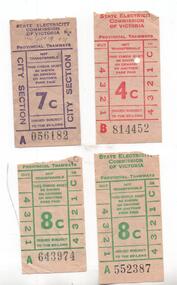
Ephemera - Ticket/s, State Electricity Commission of Victoria (SECV), Set of 4 decimal currency tickets, late 1960's
Has a strong association with the Ballarat and Bendigo tramway system as being identified as being used on the system and for which trip on a specific date and demonstrates the ticket style at the time of closure of Ballarat.Set of 4 decimal currency tickets used on the Ballarat or the Bendigo tramway system with three of them noted as to their use on the rear. 1 - 4c red - B814452 - ?? Bgo, Sat May 19, 1969, Tram No. 2 - Concession 2 - 7c purple - City Section - A056182 - tram 42 - Sun Sept 19, 1971 (last day of trams in Ballarat) 3 - 8c green - A552387 - 845am, tram 40 to Sebastopol, Sat Sept 19, 1971 4 - 8c green - A643974 - 745pm, tram 40 to Sebastopol, Sat Sept 19, 1971 trams, tramways, tickets, secv, ballarat, bendigo, sebastopol, closure, last day -
 Ballarat Tramway Museum
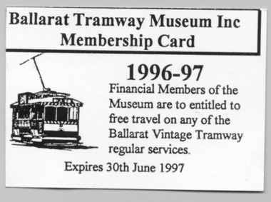
Ephemera - Membership Card, Warren Doubleday, Jul. 1996
689 - Paper/light cards, white, printed for Ballarat Tramway Museum Membership card for year 1996-1997. On rear is a label printed for "85 W.Doubleday" stuck to surface. 689.1 - ditto for 1995 - 96 - has label on rear. First membership card with Museum name on it, had changed name during the previous financial year. Added 6/11/2005. 689.2 - Card issued to C. Dean, No. 42 for 1996 - 1997 689.3 - blank card, no label on back, but one has been removed - from C.Dean 26-06-2006trams, tramways, btps, membership cards, btm -
 Ballarat Tramway Museum
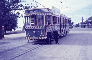
Slide - 35mm slide/s, Travis Jeffrey, c1962
Agfa plastic mount (blue base, white cover) of a photograph of No. 42 at Lydiard St. North. Photo taken c1962. Tram has destination of Rubicon St . Tram fitted with an SEC cook with electricity roof advertisement. Driver, conductor, crew members are standing at the front of the tram. Note the drivers window is in the open position. Photo has the cemetery gates (New Cemetery) in the background. Slide rescanned at 3200 dpi 25-10-2020, jpg replaced, tiff file retained. This file was scanned in 2003 and may show colour changes. "BAS 32" in penciltramways, trams, lydiard st nth., new cemetery, tram 42 -
 Ballarat Tramway Museum
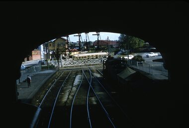
Slide - 35mm slide/s, Ben Parle, 8/04/1958 12:00:00 AM
Kodachrome Transparency - 35mm slide - cardboard mount, with one side with red border and words "Kodachrome Transparency / Processed by Kodak" top and bottom. Photo taken by Ben Parle 8/4/1958. Has slide No. "16" stamped in red in top corner. Photo of Ballarat No. 42 crossing the rail crossing, Lydiard St. North, Ballarat Railway Station. Taken from the footbridge within the station roof. A K class hauled goods is waiting on platform No. 2 to leave the station. Has the signal gantry and "B" signal box in the background. "Lydiard St Ballarat 8-4-58"tramways, trams, lydiard st, railway, level crossings, ballarat railway station, tram 42 -
 Ballarat Tramway Museum
Photograph - Digital image, Joy Waller, 19/09/1971 12:00:00 AM
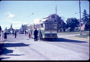
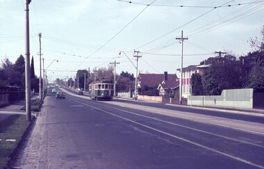
Copy of a colour slide showing Tram 42 in Lydiard Street North, at the terminus. This photo is taken from the south west looking up Lydiard Street. The cemetery gates can be seen in the background. The trolley pole it is ready to head back into the city, and the destination board is reading Sebastopol. There are children and the crew posing beside the tram for the photograph. There is a crowd of people, standing on the road near the tram, and others waiting to take photos. The photographer says this was taken of the last of the last tram to run in Lydiard Street in 1971. Photo quality is poor as the original image was blurred.trams, tramways, ballarat trams, crews, houses, last day, lydiard st nth, secv tramways, street scene, terminus, tramway closure, maximum traction, cemetery, tram 42 -
 Bendigo Historical Society Inc.
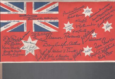
Flag - Aileen and John Ellison Collection: The Churchill flag
BHS CollectionBritish flag signed by dignitaries and world leaders. The flag was manufactured in 1941/42 as part of the Red Cross drive to raise money. On the back a message to the Hon. Wiston Churchill sent by Australians as an expression of admiration, confidence and gratitude, inspired by the conduct of the citizens of Britain, whose patient endurance, high courage and will to win in the present crisis have proved their loyalty to the tradition of their country and their race and heartened their kinsmen in every corner of the British Empire. Following this message the back of the flag list the name and titles of the signatories and a brief history of the flag and the scroll of appreciation dedicated to the people of Britain. winston churchill, red cross, world war ii -
 Falls Creek Historical Society
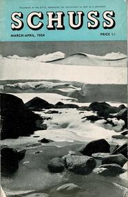
Journal - Schuss Vol. 20. No. 2 March - April 1954
Schuss was advertised as Victoria’s Official Ski Journal It was issued monthly from 1935 to 1961 except during the war when summer issues covered two months. This continued after the war, but it averaged 10 issues annually over its 25 year life. Schuss was published by the Ski Club of Victoria which had a membership of 38 Ski Clubs and demanded to be recognised as the prime authority on skiing in the state. The other 30 ski clubs with 85% of the members disagreed and the politics of skiing became heated. These clubs formed the Federation of Victorian Ski Clubs with their own journal, Ski Horizon. With the establishment of the Victorian Ski Association, Ski-Horizon published its last issue in Nov - Dec. 1955 and the role of the official journal was fully taken over by “Schuss”. This item is significant because it contains stories, images and information documenting the development of the ski industry in Victoria.The journal features stories and events chronicling developments in Victoria and internationally. Items related to the Falls Creek Area in this issue include:- Page 42 - SKYLINE LODGE at Falls Creek is in good demand again this season and many bookings have already been made. There are still vacancies in July, but members wanting them will have to hurry if they wish to sample the powder snow of that period and ride the Nissen Ski Tow. Easy road access to Howman's is of course one of the big attractions here. Several new club lodges are in progress at present in the Falls Creek village.schuss journal, skyline lodge, nissen tow -
 Melbourne Tram Museum
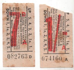
Ephemera - Ticket/s, Victorian Railways, Victorian Railways electric tramway and motor coach services tickets, 1956 and 1959
Set of two Victorian Railways electric tramway and motor coach services tickets with pencil notes on rear. 1 - 7d - paper, black printing red fare, number 082763d - "Sun 5 Feb 1956 Tram No. 42 went from Mid Brighton SLC here 1st towards BB rtn M Bright etc Brighton Beach". 2 - 1/- - as above - 074160A - 12.11am (approximate but could be later) from St Kilda - Elwood (Ride Free), Tram 28, last VR Tram Sunday 1 March 1959"See above.trams, tramways, vr, tickets, st kilda, st kilda brighton, last tram, elwood -
 Melbourne Tram Museum
Slide - Set of 2, Keith Caldwell, 30/04/1964 12:00:00 AM
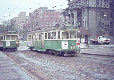
.1 - Agfa colour slide, blue / white plastic mount, photo by Keith Caldwell of W5 767 (Route 11, City Spencer St) and 821 (Kew Depot, route 47). Has the shelter at this stop in the photo. In the photo are tram adverts for Drambuie, Olympic Tyres. .2 - W2 268 running a route 12, to the City Brunswick St with W2 446 in the background, running Mont Albert route 42. Tram 468 has a Remy Martin brandy advert. The St Vincent's Hospital complex is in the background in both photos. 30/4/1964In ink "W2 PM 30-4-64"trams, tramways, route 11, route 47, route 12, route 42, mont albert, city brunswick st, w5 class, w2 class, victoria parade, gisborne st, st vincent's plaza, shelters, kew depot, tram 821, tram 767, tram 268, tram 446 -
 Maldon Vintage Machinery Museum Inc
"Romulus" Costume
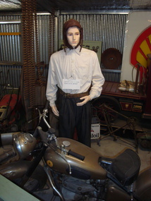
Leather helmet, cream shirt, charcoal grey trousers with button fly. Leather belt and pair of leather boots. Helmet lining is 100% black ribbed cotton. .1) & .2) shirt & trousers; .3) helmet; .4) belt; .5) & .6) boots. Right boot has hole drilled through sole to accommodate spike at base of display mannequin's leg. Belt is marked on inside near the buckle "Hero / 38"".Left boot has a white sticker "hora" painted in black. Right boot has black "X" on outside top. Both boots have "ooDED (?) / HURRAY 42" moulded into leather on outer surface of inside edge of tops. Trousers have stick on label "ROM 4" inside back of waistband.costume, male -
 Melbourne Tram Museum
Album - Robert Thomson Slide Collection, "Melbourne 1965 April Box 1", April 1965
Photo - see pdf file for further information. Number Brief Description RT107 Whitehorse Road - tram 378 - "City" - route 42 RT108 Malvern Depot - tram 947 - "Malv Tn Hall" - route 6B RT109 tram 7 RT110 tram 7 RT111 North Fitzroy - tram 980 - East Brunswick - Blyth St - route 96 RT112 North Fitzroy - tram 980 - East Brunswick - Blyth St - route 96 RT113 Hawthorn Depot - tram 17 RT114 Location ? tram 471 - "City" - route 7 RT115 Deepdene - tram 848 - "City" - route 42 RT116 Wattle Pk Ter - tram 368 - "City" - route 70 RT117 East Brighton Ter - tram 105 - "East Brighton via Caulfield" - route 64 RT118 Simpson St Siding - tram 889 - "Spencer St" - route 48 & tram 249 -"Football" RT119 Swan St Relay - tram 517 - "Wattle Park Elgar Rd" - route 70 RT120 tram 401 - "City" - route 70 - Swan St RT121 tram 401 - "Wattle Park Elgar Rd" - route 70 - Swan St RT122 tram 330 - "City" - route 70 - Swan St Demonstrates the work of Robert Thomson in photography, collection and/or production of slidesAssembled album in a black presentation folder of 16 colour slides, collected or produced by Robert Thomson. All photographs have been scanned and placed on the Museum's G drive. A list of all photographs with details has been compiled. melbourne, tramways, trams -
 Ballarat RSL Sub-Branch Inc.
Floatation Bladder, B.F. Goodrich Co, 1939-45
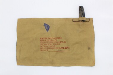
This floatation bladder was made for survival whilst crossing rivers and streams. The device would have been inserted into clothing and the user would have blown air into the pipe. The pipe would have been folded in half and held in place to prevent air from escaping.Tough rectangular, flat, khaki coloured fabric and rubber bag. There is a rubber pipe at the top, right corner. There is a fabric flap at the base of this pipe which holds the pipe in a bent position. There are also inscriptions on the front/centre of the bag.The following inscriptions are at the front/cente of the bag, printed in red. The very last inscriptions ('M. KNAUSS') are printed in dark purple. 'BLADDER, FLOATATION, JUNGLE' 'THE B.F. GOODRICH CO.' 'CONTRACT W669QM21639 9-30-42' 'SPECIFICATION P.Q.D. 243' 'STOCK NO. 74-B-303' 'PHILADELPHIA QUARTERMASTER DEPOT' 'INSPECTOR______M. KNAUSS_____' floatation bladder, floatation device, world war two, ww2, wwii, second world war -
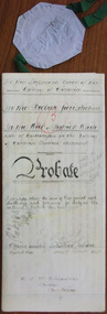 Warrnambool and District Historical Society Inc.
Document - Patrick White Probate 1897, 1897
Tait collection: item 42 of 62 This is a document giving details of the Will and Probate of Patrick White, a farmer from Codrington who died in 1883. He left personal estate to the value of £316, with the beneficiaries being his wife, Eleanor and his son George. The lawyer concerned with this document was Ernest Chambers who had legal offices in Port Fairy, Koroit and Warrnambool at the end of the 19th century and the beginning of the 20th century. He had possession of this document and it was passed down to successive lawyers occupying the legal premises in Kepler Street, Warrnambool and located in this Kepler Street building in 2014. This document is of minor significance as Patrick White was not a resident of Warrnambool. The interest lies in the fact that the lawyer, Ernest Chambers, practised in Warrnambool in the 19th centuryThis is a cream-coloured piece of parchment paper containing details of the Will and Probate of Patrick White of Codrington who died in 1883. The paper is folded in two and the edges of the pages have blue lines ruled on them. There is handwritten material (black ink) on three of the pages. The seal of the Supreme Court of Victoria is attached with olive-green ribbon and there are five red stamps of the Master in Equity of the Supreme Court. The writing is fading in places but the document is readable. In the Supreme Court of the Colony of Victoria In the Probate Jurisdiction In the Will of Patrick White late of Codrington in the Colony of Victoria Farmer deceasedpatrick white,, codrington, ernest chambers, warrnambool history -
 Eltham District Historical Society Inc
Photograph - Aerial Photograph, Landata, Research, Vic, Apr. 1963
Centred on present day Marconi Court, Research bounded by Maroondah Aqueduct to north, Thompson Crescent to south, Joselyn Drive to east and Eltham Research Oval to west. Historic Aerial Imagery Source: Landata.vic.gov.au Aerial Photo Details: Project No :486 Project : MELBOURNE (1963) PROJECT Run : 5 Frame : 62 Date : 04/1963 Film Type : B/W Camera : RC8 Flying Height : 5100 Scale : 9600 Film Number : 1805 GDA2020 : 37°42'24"S, 145°10'43"E MGA2020 : 339434, 5825157 (55) Melways : 22 F3 (ed. 42)aerial photo, neil webster collection, 1963-04, joselyn drive, marconi court, melway 22f3, research (vic.), research oval, thompson crescent -
 Eltham District Historical Society Inc
Photograph - Aerial Photograph, Landata, Research, Vic, Apr. 1972
Centred on present day Maroong Drive, Research bounded by Allendale Road to north, Thompson Crescent to south, Eltham College to east and Parsons Road to west. Historic Aerial Imagery Source: Landata.vic.gov.au Aerial Photo Details: Project No :985 Project : MELBOURNE 1972 Run : 26 Frame : 193 Date : 04/1972 Film Type : B/W Camera : RC10 Flying Height : 5700 Scale : 9600 Film Number : 2636 GDA2020 : 37°42'04"S, 145°10'33"E MGA2020 : 339187, 5825794 (55) Melways : 22 F1 (ed. 42)aerial photo, neil webster collection, 1972-04, allendale road, eltham, eltham barrel, eltham college, maroong drive, melway 22f1, parsons road, research (vic.), thompson crescent -
 Eltham District Historical Society Inc
Photograph - Aerial Photograph, Landata, Eltham, Vic, Apr. 1972
Centred on present day Ryans Road at Sandra Avenue, Eltham bounded by Progress Road to north, Brougham Street to south, Bible Street to east and Outlook Crescent to west. Historic Aerial Imagery Source: Landata.vic.gov.au Aerial Photo Details: Project No :985 Project : MELBOURNE 1972 Run : 27 Frame : 48 Date : 04/1972 Film Type : B/W Camera : RC10 Flying Height : 5700 Scale : 9600 Film Number : 2636 GDA2020 : 37°42'41"S, 145°08'38"E MGA2020 : 336392, 5824574 (55) Melways : 21 H4 (ed. 42)aerial photo, neil webster collection, 1972-04, eltham, bible street, brougham steet, melway 21h4, outlook crescent, progress road, ryans road, sandra avenue, montmorency -
 Eltham District Historical Society Inc
Photograph - Aerial Photograph, Landata, Montmorency, Vic, Apr. 1972
Centred on present day Olympic Avenue at Grand Boulevard, Montmorency bounded by Meruka Drive to north, Main Road to south, Main Road to east and Alban Street to west. Historic Aerial Imagery Source: Landata.vic.gov.au Aerial Photo Details: Project No :985 Project : MELBOURNE 1972 Run : 28 Frame : 206 Date : 04/1972 Film Type : B/W Camera : RC10 Flying Height : 5700 Scale : 9600 Film Number : 2635 GDA2020 : 37°43'21"S, 145°07'46"E MGA2020 : 335154, 5823329 (55) Melways : 21 E7 (ed. 42)aerial photo, neil webster collection, 1972-04, eltham, alban street, grand boulevard, lower plenty, main road, melway 21e7, meruka drive, montmorency, olympic avenue -
 Eltham District Historical Society Inc
Photograph - Aerial Photograph, Landata, Eltham, Vic, Apr. 1972
Centred on present day Mays Road at Stringybark Road, Eltham bounded by Nyora Road to north, Yarra River to south, Reynolds Road to east and Bible Street to west. Historic Aerial Imagery Source: Landata.vic.gov.au Aerial Photo Details: Project No :985 Project : MELBOURNE 1972 Run : 28 Frame : 209 Date : 04/1972 Film Type : B/W Camera : RC10 Flying Height : 5700 Scale : 9600 Film Number : 2635 GDA2020 : 37°43'33"S, 145°09'28"E MGA2020 : 337647, 5823013 (55) Melways : 22 B8 (ed. 42)aerial photo, neil webster collection, 1972-04, eltham, bible street, mays road, melway 22b8, nyora road, reynolds road, stringybark road, yarra river -
 Eltham District Historical Society Inc
Photograph - Aerial Photograph, Landata, Eltham, Main Road; Henry St to Bellevue Rd, Dec. 1945
Eltham, Main Road; Henry St to Bellevue Rd, and east along Luck St to present day Eltham East School Historic Aerial Imagery Source: Landata.vic.gov.au Aerial Photo Details: Project No :5 Project : MELBOURNE AND METROPOLITAN AREA PROJECT Run : 36 Frame : 60549 Date : 12/1945 Film Type : B/W Camera : EAG4 Flying Height : 10200 Scale : 6000 Film Number : 228 GDA2020 : 37°42'45"S, 145°08'59"E MGA2020 : 336903, 5824465 (55) Melways : 21 K4 (ed. 42)aerial photo, arthur street, bellevue road, bible street, diamond street, dudley street, elsa court, eltham, eltham east primary school, gahan house, henry street, livingstone road, luck street, main road, pryor street, neil webster collection -
 Moorabbin Air Museum
Machine - Consolidated PBY-5A(M) CAtalina A24-88 ("RK-A" , BU48352) (Fuselage)
Historical Details: The PBY Catalina aircraft A24-88 was delivered to the RAAF in March 1944, and was one of 29 new PBY-5A Amphibians sent to No 1 Flying Boat Repair Depot at Lake Boga Victoria for a 1500 man-hour conversion back to pure flying boat configuration by removal. Description: The PBY Catalina is the worlds most successful flying boat with 3,272 examples being built. After the outbreak of World War 2 the RAAF received 168 Catalinas. Our aircraft was delivered to the RAAF in March 1944 and served with No.42 Squadron from Augu. Level of Importance: National -
Moorabbin Air Museum
Archive (Item) - Box BDA4 Boeing (Gaf / Asta) Collection
Description: Box BDA 3 - 5 folders - labelled: BOOK No 3 N22 N000 - 545 to N000 - 900 BOOK No 4 N24.000.246 to N24.000.555/2 BOOK No 5 N24.000.625/1 BOOK No 6 N22 & N24 COMPONENT STAGES N110 - 100 to N120 - 35 BOOK No 7 N120 - 42 to N250 - Level of Importance: National. Historical Details: DAP/GAF/ASTA constructed many overseas designs under licence in Australia (Beaufort, Beaufighter, Lincoln, Canberra and F18) however they also designed and constructed a number of significant local designs that were successful in oversea's markets includi -
Federation University Historical Collection
Handbook, Ballarat Teachers' College Handbook 1964, 1964
This handbook is the 1964 edition of the Ballarat Teachers' College Handbook, a publication listing various details regarding various aspects about the Ballarat teachers college, in particular focusing on the important details for the school year for 1964. Included within is a foreword by the then-principal T. W. H. Turner, a history of the Ballarat Teachers' College, 1964, a course programme, a list of faculty staff,and a list of courses available.Ballarat Teachers' College logo recto and on 1st page. The inscription "Alex. Ball V1" is included on the first page in the top right hand corner in ink. Registration number "11736" verso. A small handbook, 42 pages long. Blue inked text on recto, Black inked text inside. Pencil mark on verso.ballarat teachers' college, 1964, handbook, alex ball, t.w.h. turner, ballarat -
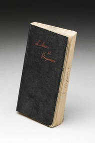 Tatura Irrigation & Wartime Camps Museum
Book - Italian Prayer book, L'Amico del Prigioniero, 1943
Else Oertel was an internee in Camp 3A from 1940-1945. Else (a German) was interned in the same compound as many Italians. Her Italian neighbours, Mr & Mrs Manlio & Henrietta Pecchioni presented this prayer book to her in memory of their internment together. This & other items were donated by her daughter, Else-Lore.Prayer book in Italian language. Book with black cover. Red writing on front cover: "L'Amico del Prigioniero". 486 pages.Inside front cover: C/O of D. Mazzieri Via Vittorio Emanuele 42 Parma Italia|Frontispage: To my Friend with my love. Eta(?) Pecchioni.|Frontispage, again: Inscription in Italian, believed to read "To our dear, kind Friend & companion of misadventure", M. Pecchioni, (internment number) 25234, Tatura 26.7.43tatura, ww2, italian language, camp 3, internment, internee camps, prayer book, books, religion -
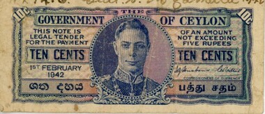 Dandenong/Cranbourne RSL Sub Branch
Currency - Ceylon Bank Note, 1st February 1942
Given the inscription, it is possible this note belonged to MCNAMARA CECIL STEPHEN : Service Number - NX1416 : Date of birth - 26 Apr 1907 : Place of birth - GUNDY NSW : Place of enlistment - SCONE NSW : Next of Kin - EILEENTen cent note from the Government of Ceylon, now Sri Lanka. It is small, rectangular and paper with blue print on one side. The back is blank except for a black six-digit number. The text is mostly in English.Front: "THE GOVERNMENT OF CEYLON / THIS NOTE IS LEGAL TENDER FOR THE PAYMENT / OF A N A MOUNT NOT EXCEEDING FIVE RUPEES / TEN CENTS / TEN CENTS / 1ST FEBRUARY 1942 / COMMISSIONERS OF CURRENCY" (what is possibly an Indian language inscription beneath) "NX1416 / Cecil. S. McNamara / 26/8/42" (handwritten in ink) Back: A / 8 / 480657"ceylon currency, sri lankan currency, 1942 bank note, wwii money -
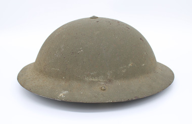 Woodend RSL
Helmet, March 1942 (lining) 1941 (helmet shell)
It is a green helmet, in the shape of a kettle hat. It is a tin hat or Brodie helmet. It is On the chin strap, there are the initials C.G.H and the service number V156143. There are size stamps on the back of the suspension webbing as well as on the underside edge of the helmet. The size is 7 1/4. On both chin strap luggs, it is engraved with MKIII 1941. On the inner lining under suspension lining it is marked with 7 1/4 L.P.L 3/42. helmet, world war 2, colin gordon hopkins, v156143, vx119387, bandiana, shell -
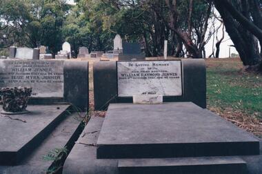 Phillip Island and District Historical Society Inc.
Photograph Album, Kodak, Phillip Island Cemetery, c 1990
The Album was compiled by Nancy McHaffie late 1990's, with the assistance of Edith Jeffery's, with her book "Garden of Memories" and extensive knowledge of Phillip Island. The Cemetery lies back from the road and is surrounded by Manna Gums, rare Peppermint Gums, Blackwoods and other native trees. In all 25 acres of land were set aside as Crown Land in the land settlement of 1868. There are 6.2 acres of wetlands near the cemetery entrance.Two photos: a) Two graves - William Jenner & Elsie Myra Jenner. William died Oct 1957 aged 73 and Elsie died April 1968 aged 82. - William Raymond Jenner - son of William & Elsie - died Oct 1951 aged 42 years. b) Close up of William & Elsie grave. William had a farm at Ventnor, grew onions and chicory and was always willing to help out or lend any farming machinery. William was a member of the Ventnor School committee and Ventnor Hall committee. He was married to Elsie Churchill of Kilcunda and they had five children.phillip island cemetery, william jenner, elsie jenner, nancy mchaffie, edith jeffery -
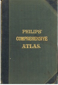 Bendigo Historical Society Inc.
Book - LYDIA CHANCELLOR COLLECTION: PHILLIPS' COMPREHENSIVE ATLAS
A gray hard covered atlas titled ' Phillips' Comprehensive Atlas of Ancient and Modern Geography.' Edited by William Hughes, FRGS. London. George Phillip and Son, 32 Fleet St., Liverpool, Caxton Buildings, South John St., 1874. 42 pgs., maps, index. NB: In the inside cover of the book is a newspaper cutting of a letter from G. Wilson Brown Secretary, Education Department, Melbourne, 12th November, 1878 advertising 'an examination of Teachers and Candidates will be held at School 1,976, Sandhurst, on Thursday and Friday, 19th and 20th December, 1878, commencing at 9.30 a.m.'Edited by William Hughes, F.R.G.S.map, lydia chancellor collection, collection, atlas, maps, world, book, books -
 Bendigo Historical Society Inc.
Book - HANRO COLLECTION: PHOTO ALBUM
Navy blue covered photo album with a beach scene on the cover. Inside, newspaper articles of a reunion at Hanro on the 28th September, 1985 and two photos of a potted plant with pink flowers. 42 coloured photograph's of Hanro's former employees at the reunion. Two copies of "Hanro News"dated Saturday 28th September. Thank you notes at the back of the Album. Hanro Christmas dance entrée card to be held at the Bendigo City Hall. Past and Present employees of John Brown (Sportscraft) are welcome to join in "The Goodbyes" on Thursday 28th November, factory closing Friday November 29th.photo, group, hanro employees -
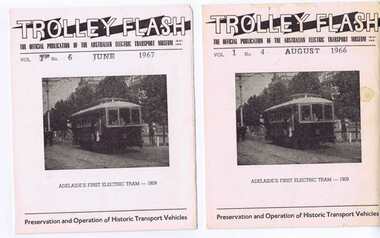 Ballarat Tramway Museum
Magazine, Australian Electric Transport Museum (SA) Inc, "Trolley Flash, Vol 1, Nos. 4 & 6", Aug. 1966
In house periodical produced by the AETM for its members and friend, pre-printed covers and page 2, with Vol No. and date hand stamped. Photo of A1 on front cover. 307.1 - Vol. 1 No. 4 - August 1966, features items on "Green Goddess" Trolley bus, reports, display in No. 42, , replacement parts and visit of MTT Publicity Officer. 307.2 - Vol 1 No. 6 - June 1967, Museum to open in July, Assistance from the EW&S, AGM, new members (includes N. Gower), Trolley bus No. 417 and electrical equipment ex Rapid Bay. Image added 16.11.2013trams, tramways, aetm, sth australia., adelaide -
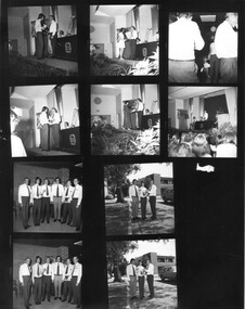 University of Melbourne, Burnley Campus Archives
Photograph - Black and white prints and negatives, Information Branch Victorian Department of Agriculture, Opening of the Student Amenities Building and Graduation Ceremony 1973, 1973
Black and white proofs and prints.Opening of the Student Amenities Building and Graduation Ceremony 1973. 2 pages of 19 small copies of Official Photographs taken at the ceremony on 13 December 1973 by the Publicity Branch of the Victorian Department Of Agriculture. Some have been catalogued seperately (B91.350-354). Also another proof with 14 photographs and 11 individual photographs of students accepting their award from Hon. Rupert Hamer. These are Photographs by Information Branch Victorian Dept of Agriculture Ref No 1981 (999) and 1981 (999-1) to (999-7), 1981 (999-40) to (999-42).On reverse, "File No. E.206," with numbers behind each photograph.student amenities building, graduation ceremony, 1973, students, hon. r.j. hamer, opening student amenities building, graduation 1973