Showing 3906 items matching "bricks"
-
 Bendigo Historical Society Inc.
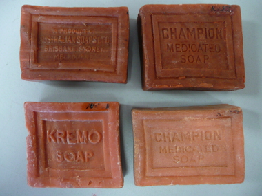
Domestic Object - MEDICATED SOAPS
4 cakes of medicated soap, 3 made by Australian soaps ltd, 1 made by Kremo soap, brick red in colour.Champion medicated soap a product of Australian soaps Ltd Brisbane Sydney Melbourne Kremo soap medicated health soapdomestic equipment, ablutions, soap -
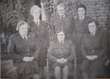 Tatura Irrigation & Wartime Camps Museum
Photograph, Internment Camp Wardens
WW2 internment camp wardens.Black and white photograph of 3 women standing and 3 women seated. Brick background to right and bushes to left behind them.wardens, army wardens, internment camp wardens, female wardens -
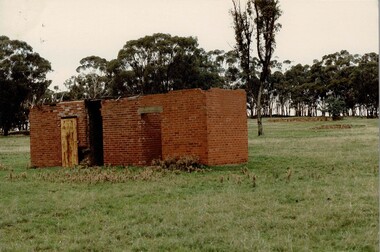 Tatura Irrigation & Wartime Camps Museum
Photograph, Camp 1 prison, 1989
The building is the remains of the prison at Camp 1. Foam backed copy in file.Coloured photograph. Red brick building in foreground. To left of building there is a wooden door. Two other doorways, no doors, flat roof.camp 1, tatura victoria, camp goals, camp building remains -
 Clunes Museum
Photograph
CONSTRUCTION OF BRIDGE OVER CLUNES CREEK.1 .2 BLACK AND WHITE PHOTOGRAPH (COPY) OF BRIDGES UNDER CONSTRUCTION - BRICK ABUTMENT. SCAFFOLDING ON TOP, WORKMEN ARE STANDING ON TOP.local history, photography, photographs, bridges -
 Stawell Historical Society Inc
Photograph, 9 Seaby Street Former Crothers Home Built 1869
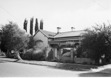
Colour Photgraph: Brick house with red Iron roof,, with 4 chimneys 7 white iron frnce in front. road in foreground9 Seaby Street -
 Stawell Historical Society Inc
Photograph, Former Stawell Ladies College 1873
Heritage Study Vol 10 SL139B/W Photo. Weatherboard home 3/4 Verandah with awnings. Bay window to left. Low brick fence in front.14 Ligar Street in red ink on back.ladies collage -
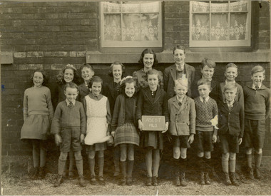
 Stawell Historical Society Inc
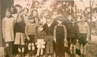
Photograph, Deep Lead Students and Teacher Circa 1954
School Photo Circa 1954 Mr A.K. Boyd, Head Teacher Pearl Mitchell, Dawn Shuttleworth, Jean Cray, Amy Cray, David Perry, Richard MItchell, Keith Mitchell, Evelyn Cray, Dorothy cray, Robert Cray, Tom Cray, Edwin Perry, Betty shuttleworth, Barry Cromwell, Bruce Richards.B/W Photo Students and Teacher outside trees in background Brick building wall to Left of Photo and wire fence to right.deep lead school, education -
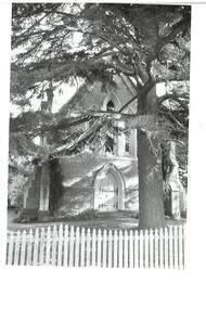
 Stawell Historical Society Inc
Photograph, Christ Church of England Stawell
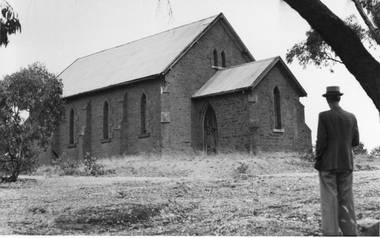
Christ Church of England built on a site granted 1862 on Church Hill. Photograph around 1940. Gentleman unknown. The building was later used as boys scouthall B/W. Photo of a Brick building on a hill, with a man wearing a hat standing in foreground with back to camera with a tree branch overheadstawell building -
 Stawell Historical Society Inc
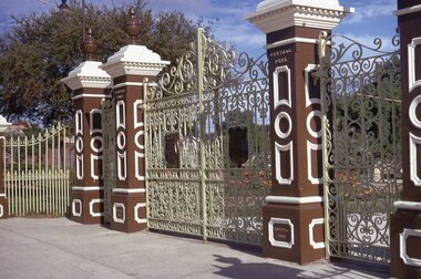
Slide, Ian McCann, Main Gates Central Park 1969
Main Gates at Central park Stawell Five Brick Colloms Iron work fence and Iron gates in centre whith shieldsOn the two central pillars. Central Park at hte top on the base erected 1903monuments -
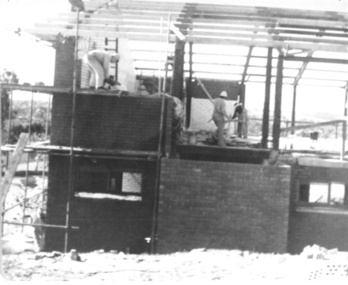 Slovenian Association Melbourne
Photo, Building of the corner of the new centre at Eltham 1972
Photo of the building team laying the bricks at the corner of the new centre. The work was voluntary at the weekends, but the building was growing quite fast. On the photo are:slovenian association melbourne, building, 1972 -
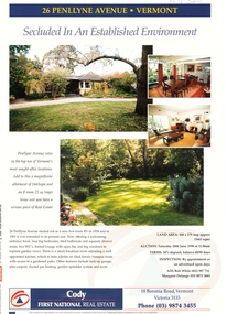 Whitehorse Historical Society Inc.
Document, 26 Penllyne Avenue, Vermont, 1/06/1998 12:00:00 AM
Auction brochure 26 Penllyne Avenue,Auction brochure 26 Penllyne Avenue, Vermont. Large allotment, brick veneer home auction June 1998. Built 1954.Auction brochure 26 Penllyne Avenue,auctions, penllyne avenue, vermont, no 26, cody first national real estate -
 Rutherglen Historical Society
Image, Olive Codling
Some of the buildings of the Mount Ophir winery. Photo was taken by Miss Olive Codling, who was a life member of the Wodonga Historical Society. Photograph is believed to have been taken on the occasion of a Tour by the North East Branch, 1st combined meeting.Black and white photograph of a brick building with corrugated water tanks on the roof and an attached roof area, probably to supply shelter for deliveries.mt ophir, mount ophir, wine industry -
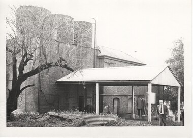
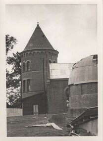 Rutherglen Historical Society
Image, Olive Codling
Some of the buildings of the Mount Ophir winery. Photo was taken by Miss Olive Codling, who was a life member of the Wodonga Historical Society. Photograph is believed to have been taken on the occasion of a Tour by the North East Branch, 1st combined meeting.Black and white photograph of brick buildings, one of them with a tower. To the right in the foreground is a building with a domed roof, the roof in poor repair.mt ophir, mount ophir, wine industry -
 Buninyong & District Historical Society
Photograph - Original B/W Photograph, Former Methodist Church in Warrenheip St, Buninyong, 4th April 1994
This building was the former Buninyong Methodist Church, but is now a private residence.This former church building is of historic and social significance.Original B/W Photograph of a brick building, formerly the Methodist Church in Warrenheip St south, Buninyong. Now a private residencemethodist church, buninyong, brick building, warrenheip st -
 Stawell Historical Society Inc
Memorabilia - Realia, c1880's
Red fired brick with name Newell Stawell (located at old Showgrounds). Found at old mine site Illawarra State Forest stawell -
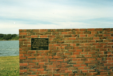 Lakes Entrance Historical Society
Photograph - War Memorial, Bess Larkins, 1989
Colour photograph brick wall with plaque explaining establishment of forecourt at Lakes Entrance WW1 Memorial on Esplanade. Lakes Entrance Victoriaworld war 1914-1918, memorials -
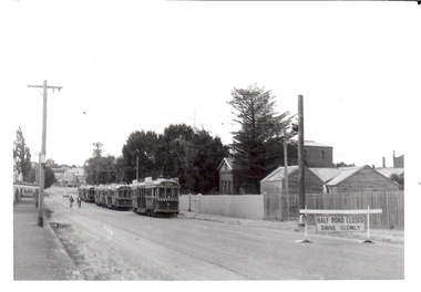 Bendigo Historical Society Inc.
Photograph - BASIL MILLER COLLECTION: TRAMS - EAGLEHAWK
Eaglehawk Court House, (brick building centre right), 4 bogie trams on left. Number 'C922' stamped on back of photo.basil miller, bendigo trams -
 Old Gippstown
Building - Loren Iron House
'Loren' (formerly James Hogg's house) is a two-storey gabled prefabricated house, constructed using broad-gauge corrugated iron and was originally erected at 60-62 Curzon Street, North Melbourne in 1853 for builder, James Hogg. By 1968 the building had deteriorated and it was dismantled and moved to Old Gippstown where it was re-erected and restored. The building's external framing system consists of exposed metal columns with Gothic panel motifs at the corners. Internally the timber framed walls have been finished with new papers over new Hessian. The corrugated iron roof has an unusual concave form and the windows, floors and doors are of moulded softwood. State historic significance as a rare type of iron prefab. house. Listed on the Victorian Heritage Register and covered by a Heritage Overlay, Latrobe City Planning Scheme. It is also listed on the Register of the National Estate.Tall square-shaped two-storey corrugated iron building with a curved corrugated iron roof with two outside brick chimneys. prefabricated iron houses, old gippstown, west gippsland, gippsland, gippsland heritage park, goldfields, coal mine, victorian era, moe, historical village, city of melbourne, north melbourne, curzon street, james hogg, prefabricated house, two-storey gabled prefabricated house, old gippstown heritage park, latrobe valley, loren, latrobe city council -
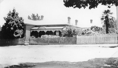
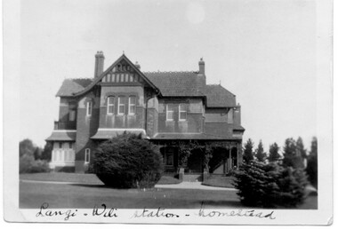 Linton and District Historical Society Inc
Photograph, Langi Willi homestead
Langi Willi station, between Pittong and Skipton, was settled by Mr George Russell in the 1800s. His daughter, and her husband Mr E.D. McKinnon and afterwards their children continued to own and manage the property until recently. Architect: Charles D'Ebro. Date built: 1903Black and white photograph of a large two story brick house with pitched roof set in well kept garden - lawn and trees."Langi Willi Homestead".langi willi station, homesteads, houses, pittong, george russell, mckinnon family, skipton -
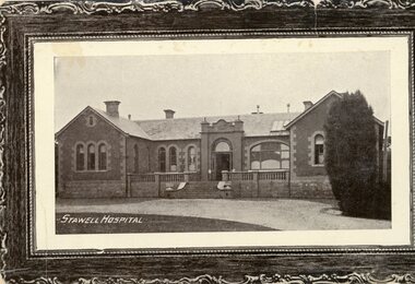 Stawell Historical Society Inc
Postcard, Pleasant Creek Hospital built 1861
Pleasant Creek Hospital with garden nurses standing in garden and at top of steps. Built 1861B/W photgraph of a brick building with wings either side, pine tree on the right. surrounding the picture is a fdrawn wooden frame.Front, Lower Left: Stawell Hospital On reverse: Post Card. This Space used for communication. Address Only On the Left Side: Semco Series. Box 545 G.P.O. Melbourne ( Turn 90 Degrees Clockwise to read)stawell -
Canterbury History Group
Photograph - Street view of the enamelled picture plaque of the former Canterbury Station, Jan Pigot, 2004
Coloured photograph of the street view of the enamelled picture plaque of the former Canterbury Station on the brick wall at No. 111 Maling Road, Canterburycanterbury, maling road, theatre place, shops, signs, plaques -
Canterbury History Group
Photograph - Street view of the enamelled picture plaque of the former Canterbury Station, Jan Pigot, 2004
Coloured photograph of the street view of the enamelled picture plaque of the former Canterbury Station on the brick wall of No. 111 Maling Road, Canterburycanterbury, maling road, theatre place, shops, signs, plaques -
 Federation University Historical Collection
Photograph, S.J. Campbell, Students of Ascot Primary School, 1940
Members of the Chatham family will be depicted in this photograph.Mounted black and white photograph Ascot Primary School, 1940, depicting 16 students standing in front of a brick school building. verso In blue ball point pen "Chatham" Stamped "S.J. Campbell Photographer Post Office, East Melbourne.chatham, chatham family collection, ascot, education, school, ascot primary school, ascot state school -
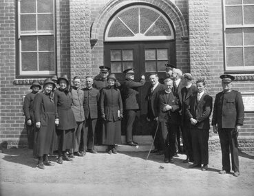 Stawell Historical Society Inc
Photograph, Salvation Army Citadel Official Opening December 1934
Salvation Army Citadel Opening 1934. People in front of Citadel. Front Row from Left Mrs. Wilkinson, Mrs. Haines, Capt. Morris, Brig. Smalley, Col. Henry Mrs. Maxwell, Comm. Maxwell, Cr. Freeland, (Mayor), Col. Haines, Cr. R. McCracken, Rev. Ewin, Rev. Graham, Mr. Sharpley, Major Wilkinson. Black and white photograph of a group of people in uniform at an entrance to a brick building. The man in the center of the group appears to be opening the door to the building.. W.J. Chapman Photo artist Stawell. Col. A. Henry, Commissioner Maxwell, Col. W. Haines, Brig. F. Smalley, Mr. S. Freeland, Mayor of Stawell, Mr. R McCracken, Capt. F. Morris, Mrs. Col Haines, Mrs. Major Wilkinson, Town Clerk Mr. Sharpley, Major F. Wilkinson.stawell religion -
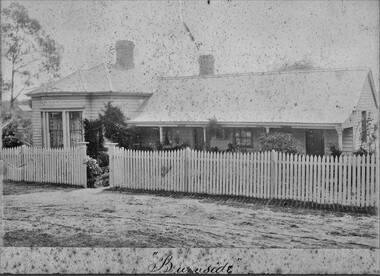 Stawell Historical Society Inc
Photograph, "Burnside" House
Huttley Martin FamilyB/W front if home weatherboard, front porch, bay window, fron garden with paling fence. Two brick chimneys"Burnside" On Reverse Old Family Home Stawell West MATSON & Co., Photographershuttley, martin -
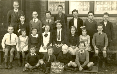 Federation University Historical Collection
Photograph - black and white, Ascot State School No. 2507
Black and white photograph of a male teacher and 19 of his students in front of a brick school. The school of Ascot State School No 2507.Verso 'Chatham Ascot'chatham family archive, ascot, education, state school, primary school, teacher -
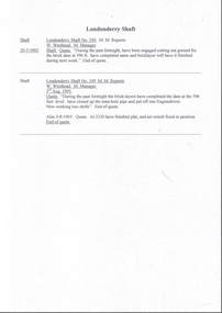 Bendigo Historical Society Inc.
Document - MINING REPORTS - LONDONDERRY SHAFT NO 249
' The old Londonderry Mine shaft has been capped after it opened in late July. The shaft was part of the Garden Gully Line, which held the greatest concentration of workings on the Bendigo Goldfield, has been capped after it opened in late July. The line starts under the Quarry Hill Golf Course and continues right through to Eaglehawk North'. (Source: Bendigo Advertiser, August 19, 2014.) Mine was located on Creek Street North, Bendigo. Central Deborah - Heritage Victoria Notes: Originally the Londonderry West shaft, now a mining museumHandwritten extracts by Albert Richardson (with typed copy of same) on the Londonderry Shaft, Bendigo in 1905, with reference to the brick dam being constructed.gold, mining reports, londonderry shaft no 249, w westhead -
 Stawell Historical Society Inc
Photograph, Mahnke Family Home in Sloane Street Stawell
Brick Home Sloane Street (Mahnke) stawell -
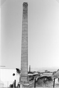
 Stawell Historical Society Inc
Photograph, Stawell Brick Company 1997
Brickworks - Stawell Brick Co. 1997stawell -
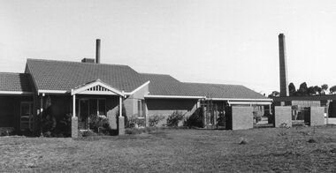
 Stawell Historical Society Inc
Photograph, Stawell Brick Company 1997
Brickworks - Stawell Brick Co. 1997stawell