Showing 2047 items
matching building and construction
-
 Federation University Historical Collection
Booklet, Ballarat School of Mines Prospectus A and B, 1916-7, c1917
The Ballarat Technical Art School was part of the Ballarat School of Mines.1) Ballarat School of Mines Prospectus A .2) Ballarat School of Mines Prospectus B Contents includes teaching staff, school hours, curriculum, fee list, Travelling concessions, school library, classification of subjects. scholarships, Full art and Craft Courses (Industrial Design; Figure, Modelling, Painting and Design; Figure Drawing, Modelling, Painting and Design; Fashion Plate Drawing; Black and White Illustration; Modelling; Wood Carving and Lettering; Art Metal Work; Retouching, colouring, &c; Architectural Diploma; Draughtsmen's Courses; Art Teachers' Courses; Outdoor Sketching Classes; Photography; Building Construction and Architectural Drawing; Ticketwriting; Signwriting and Decorating COurse; Dressmaking, Needlework, etc; Preparatory Technical Classes for Girls; Day Commercial Classes; Other Branches of the School's Activities, examination results; Art Teachers' Certificate. Includes an image of W.H. Middleton, President of the Ballarat School of Mines; Staff of the Ballarat School of Minesballarat school of mines, ballarat technical art school, design, modelling, figure drawing, fashion plate drawing, black and white illustration, wood carving, lettering, art metal work, retouching, architecture, architectural diploma, draughtsmen's courses, art teachers' courses, outdoor sketching classes, photography, building construction, architectural drawing, ticketwriting, signwriting and decorating, dressmaking, needlework, art teachers' certificate. -
Kew Historical Society Inc
Archive (Sub-series) - Subject File, Kew, City of - Management, 1958
City of KewReference, Research, InformationKHS Imposed OrderKew in Victoria was declared a City in 1921, and remained so until it was amalgamated into the City of Boroondara in 1994. This is a single large archive file, primarily comprised of Kew Council documents, a number of which date from an earlier period. Interesting early primary sources include: 1914 Amendments to the Local Government Act of 1903 [copy owned by Mr W.J. Muntz C.E.]; a Cleansing Contract [for the removal of night-soil] (1913); an Annual Statement of Accounts (1923); and By-Law No.66 (1939) [relating to the “Erection Construction and Removal of Buildings, Advertising Signs, Etc.”; and the Councillor’s Handbook (1939). In addition to these, later publications relate to Financial Statements (1986, 1987, 1988); Model Local Laws (1989); a Municipal Emergency Management Plan (1990); Mobile Bin Recycling Trial (1991); a School Project Kit (1991-2); and Committee Minutes (1992). There are also a number of newspaper articles/clippings on Council management issueslocal government - kew (vic) - publications, city of kew - management, city of kew - amendments to the local government act 1903, city of kew - by-laws, city of kew - financial statements, city of kew - councillor's handbook, city of kew - municipal emergency management plan 1990, city of kew - mobile bin recycling trial (1991)local government - kew (vic) - publications, city of kew - management, city of kew - amendments to the local government act 1903, city of kew - by-laws, city of kew - financial statements, city of kew - councillor's handbook, city of kew - municipal emergency management plan 1990, city of kew - mobile bin recycling trial (1991) -
 Federation University Historical Collection
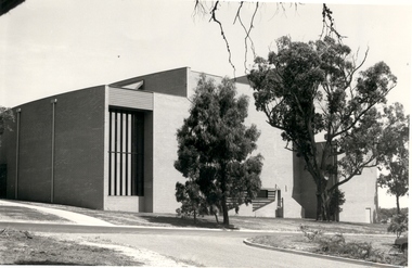
Photograph - Black and White Photograph, 1870 Founders Hall, Mount Helen Campus, 1981
In the course of celebrating the Ballarat School of Mines centenary in 1970, the School Coundil launched a building appeal for erection of a Great Hall at tehe then new Mount Helen campus of its tertiary division. In 1976 the tethertiary division of the School of Mines was, by government decision, merger with another tertiary institution in Ballarat to vreate the Ballarat College of Advanced Education while the remainder of the School of Mines continued to be based at Lydiard Street serving the needs of Technical and Further Education. The 1870s Founders Hall, erected from the provceeds of the Centenary Appeal for a sum of approximately $800,000, commemorats the intiative of the founders of the original School of Mines and its "descendants", including Ballarat C.A.E., as well as formal technical education in Australia. The hall accomodates approximately 670 people in theatre type seating and was intended for multiple purpose use by community groups as well as by the College. Construction of the Hall commenced in 1878. It was opened approximately 110 years after the opening of the Ballarat School of Mines, and 10 years after the opening of the Mount Helen campus.Photograph of Founder Halls, most probably taken soon after contruction.founder hall, caro conference centre, buildings, mount helen campus -
 Federation University Historical Collection
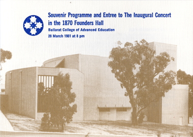
Programme - Invititation, Invititation and Programme for the Opening of 1870 Founders Hall, Mount Helen Campus, 1981
In the course of celebrating the Ballarat School of Mines centenary in 1970, the School Coundil launched a building appeal for the erection of a Great Hall at tehe then new Mount Helen campus of its tertiary division. In 1976 the tertiation division of the School of Mines was, by government decision, merger with another tertiary institution in Ballarat to vreate the Ballarat College of Advanced Education while the remainder of the School of Mines continued to be based at Lydiard Street serving the needs of Technical and Further Education. The 1870s Founders Hall, erected from the proceeds of the Centenary Appeal for a sum of approximately $800,000, commemorats the intiative of the founders of the original School of Mines and its "descendants", including Ballarat C.A.E., as well as formal technical education in Australia. The hall accomodates approximately 670 people in theatre type seating and was intended for multiple purpose use by community groups as well as by the College. Construction of the Hall commenced in 1878. It was opened approximately 110 years after the opening of the Balalrat School of Mines, and 10 years after the opening of the Mount Helen campus. Programme for the opening of Founder Halls.founder hall, caro conference centre, buildings, mount helen campus, founders hall, ballarat school of mines, centenary -
 Otway Districts Historical Society
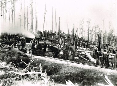
Photograph, Victorian Railways, Between Devitt Bros. Siding & Ditchley, 1901, 1901
Construction of the Colac-Beech Forest railway line began in 1900 with about 100 men engaged in laying and ballasting the track, as well as others forming the earthworks and building culverts and bridges. The result of this labour saw the railway advance from Colac until it climbed a spur hugging the side of a forty degree slope emerging on top of the ridge at Beech Forest. This photograph was taken 28 miles (45 kilometres) from Colac between Devitt Bros. Siding and Ditchley, just out of Beech Forest. Two 2-6-2 Tank engines of the narrow-gauge A class built by Victorian Railway's Newport workshop, were commonly dubbed 'Coffee Pots'. As well as pulling a load of NQR wagons a NBB saloon car ended the train. The devastation to the standing timber was deliberate: the Engineer-in-Chief of VR ruled that all trees within a certain distance of the railway line were to be cut down. This certainly saved the line from destruction several times in the future.B/W. An NA class locomotive, NQR wagons and an NBB saloon car, all with workmen, going around a bend between Devitt Brother's Siding and Ditchley on the Beech Forest line in 1901.beech forest; ditchley; devitt bros siding, railways; -
 Kew Historical Society Inc
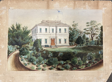
Work on paper, Madford: the property of A.S. King Esq, c.1875
The Victorian-era mansion Madford in Wellington Street had several incarnations before it was finally demolished. While the precise details of its original construction have not been discovered, we know that it was originally named Elm Lodge, and that the property was offered for sale in 1863 by Thomas Mitchell, of the firm Mitchell & Bonneau, wholesale ironmongers and merchants. The house was sold in about 1873 to William Siddeley (1827-1905), who was described on the occasion of his death as ‘the father of Australian shipping’. The next owner was Arthur Septimus King (1827- 99), who renamed the house Madford after his purchase of the property in 1875. It was A.S. King for whom this artwork was completed. Following King’s death in 1899, portions of the property were sold, including to the Borough of Kew in 1905, to form the Alexandra Gardens. Then, in 1920, the house and its remaining lands were sold to the Catholic Church who opened St Anthony’s Home for Children on the site in 1922. That building was promptly demolished, and the site redeveloped circa 1976.Gift of James Pearson, 2022This fine perspective drawing of the architectural elements of Madford [formerly Elm Lodge, later St Anthony's Home for Babies] is contrasted with the freer addition in watercolour of the layout and plants of the garden facing Wellington Street. The view selected is the south-facing main facade and the west facing side. After A.S. King purchased the house in 1875, it was extended with new wings at the rear to accommodate his large family. There is no indication of these extensions in the painting so its creation must predate the renovations, and probably depicts the original building on the site."MADFORD / The Property of A. S. KING Esq"elm lodge, madford, st anthony's home for babies, houses -- wellington street -- kew (vic.), thomas mitchell, william siddeley, arthur septimus king -
 Eltham District Historical Society Inc
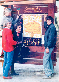
Photograph, Ron Grant, The Eltham Peace Group hanging the Hiroshima Day Banner on the Community Notice Board, Arthur Street, Eltham; Community Arts 1986 'As We Are' Banner Project Group, Hiroshima Day, 6 August 1986
Arthur Street, Eltham next to ANZ Bank The Hiroshima Day Banner was made by Jacky Talbot as part of the project. The women wanted to do something for Hiroshima Day and suggested that a workshop be set aside to make a banner. The artist was concerned about the remaining time scheduled for the project and spent several days "whipping" up the banner herself. For the artist this banner was to prove quite significant. The women hung it at the Community Notice Board on Hiroshima Day and were photographed by the local newspaper publicising the group and drawing wider community attention to the remembrance of the day. Although no new members joined the group from this activity, the artist felt that she was more fully accepted by the group afterwards. This banner has initiated a small group of women committed to peace. The artist has also continued to liaise and meet with the women as time permits. Future group plans include: making kimonos to wear when carrying the banner, participating in the Palm Sunday March, an observance of Hiroshima Day activity, which is yet to be decided, establishing contact with a sister-town in USA and USSR and supporting Eltham Council's stance as a Nuclear Free Zone. (The banner habits of the Eltham tribes : Eltham Shire "as we are" Community Banner Project report / by Jacky Talbot, Shire of Eltham, Feb. 1987, p46) Used in Shire of Eltham display at the Eltham Community Festival, 7 November 1987. Shire of Eltham Engineering Department Providing the resources to undertake • Survey, design, consultation • Road construction and maintenance • Bridge construction and maintenance • Street sweeping • Drain and pit cleaning • Traffic engineering installation and maintenance • Garbage collection • Tip management, land reclamation and beautification • Maintenance of community buildings • Provision of community and recreation facilitiesIllustrative of services provided by former Shire of ElthamColour photograph 20 x 29 cm mounted on green-painted chipboard 28 x 35.5 cm (string on back for hanging) Ref: 01842-0Title printed on label adhered to board below photograph (replaced June 2017)display panel, eltham festival, eltham peace banner, hiroshima day banner, infrastructure, shire of eltham, laurel eckersall, anne laurence, betty johnson, joan maclagan -
 City of Greater Bendigo - Civic Collection
Decorative object - Ceramic platter, Bendigo Pottery, Strathfieldsaye Shire 1866 - 1991, 1991
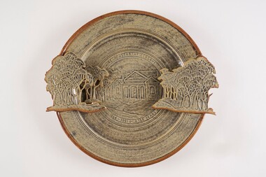
Graham Masters is a potter based at Sweenies Creek, just outside Bendigo, Victoria who specialises in a patented technique of low relief stoneware depicting Australian animals and landscapes. He obtained a Diploma of Art and Design in Ceramics from the Bendigo Institute of Technology in 1973, then operated a pottery for a year in Bendigo, before becoming an employee, then a partner at Maldon Pottery, Victoria with Neville Wilson and Thomas Metcalf. He left Maldon to set up his own pottery at Sweenies Creek in 1984. (1.) (Judith Pearce). Built in 1869, the (former) Strathfieldsaye Shire Hall is one of The City of Bendigo's earliest surviving public buildings. Designed by George Steane and built by George Pallett in 1869 the Strathfieldsaye Shire Hall has aesthetic significance as a purpose built Shire Hall designed in the Free Classical manner. It is also of importance as an early example of the novel system of cavity wall construction. The building is largely intact and unaltered. Other important elements include the arched portico of the main entrance with brick arched features on either side; the brick quoining and dressings to the round arch windows; the three gabled roof; and the matching chimneys that reinforce the symmetrical design. The Hall has social significance as a temporary schooling facility in the 1870s and as a flood refuge in 1889. The Strathfieldsaye Shire Hall is a brick building designed in the Free Classical manner. This style was favoured by the Public Works Department for a number of public buildings including Shire Halls and courthouses. The form includes a central taller volume flanked by matching smaller gables. In the case of the Shire Hall these would be occupied by the Shire Secretary and Shire Engineer whilst the larger volume was the council chamber. The portico at the front is designed with a flat arch in the centre and matching smaller arches each side. The face red brick is unadorned apart from a plain string course at the roof springing point, brick quoining and dressings to the round arch windows. There are matching chimneys that are located to reinforce the symmetrical design and the original roof is believed to have been slate but is now corrugated iron. Large wheel thrown ceramic platter with a shallow well, broad flaring ledge and raised on a high foot rim. Rim decorated with slab rolled gum trees protruding on centre left and right sides of plater. which reflect the low relief image of trees and the Strathfieldsaye Shire Hall on the surface of the plate. Glazed with golden brown and cream. Front centre top; 'Shire of Strathfieldsaye'. Front lower centre '1866 - 1991 - 125 Years'. Signed 'G Master / 1991' on rim centre right. Reverse; signed 'G Master' / 1991. Bendigo Pottery stamp.shire of strathfieldsaye, bendigo pottery -
 Flagstaff Hill Maritime Museum and Village
Domestic object - Glass
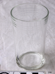
The art of making glass can be traced back to 2600 BC in Mesopotamia. Egyptians practised making glass around 2500 BC. Artificial glass first appeared in the Egyptian or the Mesopotamian civilization, whereas they used tools made out of volcanic glass obsidian in the Stone Age. Ancient China, however, discovered how to make glass a little later. Glass beads are known to be one of the earliest products made out of glass. Their creation is thought to be primarily accidental. In the later Bronze Age, glassmaking came to a halt. Glass was a luxury material back then. Archaeological excavations suggest the use of glass in England during the middle ages. In the 10th century, stained glass found a place in cathedrals and windows of palaces. After the Renaissance, architectural methods changed substantially, leading to a decrease in stained glass as a building material. Domestic use of glass increased following the industrial revolution. Vessels, glass windows, and glass beads gained popularity in Europe during this period. During the 19th century, many people preferred glass windows and doors as a decorative option. In the late 19th century, some designers brought back stained glass in decorative windows. It was during this period that Mr Tiffany discovered several methods to make domed glass handicrafts. People discovered the true versatility of using glass as a building material only in the 20th century. With glassmaking technology receiving an industrial boom, you could produce several different types of glass. Toughened glass, laminated glass, bulletproof glass, and smart glass all boosted the use of glass in buildings. Today, several skyscrapers, small and big homes, and offices use glass in almost all aspects of construction and design. https://www.aisglass.com/glass-made-step-step-process/The invention and development of glass, both as domestic items and in building, has been nothing short of revolutionary. Prior to the use of glass for windows, the interior of buildings were extremely dark, even during sunny days. The use of glass domestic objects, that could be easily washed, led to improved hygiene.Cylindrical drinking glass with stepped relief around lipNoneflagstaff hill, warrnambool, shipwrecked-coast, flagstaff-hill, flagstaff-hill-maritime-museum, maritime-museum, shipwreck-coast, flagstaff-hill-maritime-village, glass -
 Flagstaff Hill Maritime Museum and Village
Domestic object - Butter Dish
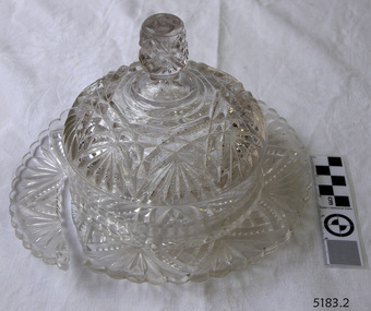
The art of making glass can be traced back to 2600 BC in Mesopotamia. Egyptians practised making glass around 2500 BC. Artificial glass first appeared in the Egyptian or the Mesopotamian civilization, whereas they used tools made out of volcanic glass obsidian in the Stone Age. Ancient China, however, discovered how to make glass a little later. Glass beads are known to be one of the earliest products made out of glass. Their creation is thought to be primarily accidental. In the later Bronze Age, glassmaking came to a halt. Glass was a luxury material back then. Archaeological excavations suggest the use of glass in England during the middle ages. In the 10th century, stained glass found a place in cathedrals and windows of palaces. After the Renaissance, architectural methods changed substantially, leading to a decrease in stained glass as a building material. Domestic use of glass increased following the industrial revolution. Vessels, glass windows, and glass beads gained popularity in Europe during this period. During the 19th century, many people preferred glass windows and doors as a decorative option. In the late 19th century, some designers brought back stained glass in decorative windows. It was during this period that Mr Tiffany discovered several methods to make domed glass handicrafts. People discovered the true versatility of using glass as a building material only in the 20th century. With glassmaking technology receiving an industrial boom, you could produce several different types of glass. Toughened glass, laminated glass, bulletproof glass, and smart glass all boosted the use of glass in buildings. Today, several skyscrapers, small and big homes, and offices use glass in almost all aspects of construction and design. https://www.aisglass.com/glass-made-step-step-process/The invention and development of glass, both as domestic items and in building, has been nothing short of revolutionary. Prior to the use of glass for windows, the interior of buildings were extremely dark, even during sunny days. The use of glass domestic objects, that could be easily washed, led to improved hygiene.Moulded patterned glass butter dish. Base has been broken.None.flagstaff hill, warrnambool, shipwrecked-coast, flagstaff-hill, flagstaff-hill-maritime-museum, maritime-museum, shipwreck-coast, flagstaff-hill-maritime-village, glass, kitchen item, butter -
 Eltham District Historical Society Inc
Document, Russell Yeoman, Tour of Historic Buildings and Locations, 1978
Self guided heritage tour information produced by the Shire of Eltham Historical Society for 1978 Eltham Community Festival of 36 locations each numbered on accompanying map. Locations and detail provided current to 1978: 1. ELTHAM SHOPPING CENTRE Whilst very little remains in the centre of historical importance, this area has interest as the "village" which developed over many years following the opening of the railway from Melbourne in 1902. Previously the shopping centre had been spread out over a long length of Main Road to the south. Shops have been continuously demolished or remodelled and the majority of buildings date from the 1950's or later. The recently erected Post Office replaced the "old" Post Office opened on the same site only in 1958. 2. WOOLWORTHS ELTHAM VILLAGE Part of the site of this modern shopping development was occupied by the former Eltham Shire Offices and Hall. The hall was paid for by public subscription whilst the Council raised a loan for the offices. The combined building was opened in 1941. It served as office and Council meeting place until 1965 and as the hall until its demolition in 1970. 3. ELTHAM WAR MEMORIAL The complex of buildings adjoining the present Shire Offices were financed by public subscription as a Memorial following World War II. Their construction and for many years their operation was organised by the now disbanded Eltham War Memorial Committee. The original buildings were the; Infant Welfare Centre, Children’s Library (now War Memorial Hall and Dental Clinic) and Kindergarten. In later years the Elderly Citizens Club was built at the rear. 4. ELTHAM SHIRE OFFICES These offices were opened in 1965 and extended in 1971 to provide additional office accommodation and the Eltham Library. They represent the last of a long line of offices and meeting places of the Eltham Shire Council and its predecessor the Eltham District Road Board. The building occupies the former site of Shillinglaw Cottage. The three tall cypress trees which stood in front of the Cottage have been retained as a feature of the office surrounds. 5. OUR LADY'S CHURCH AND SCHOOL The Catholic Church and School complex opposite the Shires Offices shows a number of stages in the development of Eltham township. The recently constructed church adjoins its predecessor (now the parish centre). Many years ago the Catholic Church was located opposite Wingrove Park and the present central site follows the northerly drift of the township. 6. SHILLINGLAW COTTAGE The Cottage was built in 1859 by George Stebbing, a local builder who was responsible for a number of other prominent buildings in the area. Its removal from the site of the Shire Offices and re-erection on the present site was financed by public subscription. It is built of handmade bricks laid in Flemish Bond with an unusual design featuring burnt "leader" bricks over the whole facade. The Cottage is occupied by Eltham Fleececrafts and will be open during the Festival and at other times during weekends. It is classified by the National Trust. 7. RAILWAY BRIDGE The timber trestle bridge over the Diamond Creek was built in 1901. Whilst all of its timbers have been replaced at various times over the years the only change to its character has been the addition of pylons and wiring for electric trains in 1923. It is one of very few similar bridges remaining in the metropolitan area. In 1976 a proposal to replace the bridge with an earth embankment and large culvert pipes was abandoned following community protests. The bridge, however, remains under threat because of the necessity for future deuplication of the railway line. 8. ELTHAM CENTPAL PARK The area between the railway and the creek has for many years been used as a park which included Eltham' s main football oval. The access road, Panther Place is named after Eltham's team playing in the Diamond Valley League. In recent years a large area extending to Bridge Street and locally known as the Town Park has been landscaped and added to the area. The excellent blending of the park with the natural landscape of the creek valley has earned a National Trust Landscape Classification. 9. OLD BAKERY On the southern corner of York Street and Main Road is an old house with a shop front which was for many years the local baker's shop. The brick bakery at the rear is of somewhat later vintage than the house. 10. BRIDGE STREET CUTTING Before reconstruction of Main Road this intersection had deep cutting embankments on all four corners, forming a distinctive feature of the entrance to Eltham. Roadworks and private development have levelled the land on the low side of the road. A memorial to the Eltham soldiers of World War I which was located at the north-western corner is now situated at the Eltham R.S.L. 11. HILLTOP MILK BAR For many years this was the site of the Eltham Post Office under the control of the Hunniford family and later their descendants the Burgoynes. It was transferred to this site in 1855, although at that time the building apparently fronted Bridge Str e et. The site contained Eltham's first telephone exchange. The post office was relocated in 1954 but the shop was operated until recently by the Burgoyne family who still own the surrounding land. 12. UNITING CHURCH and former C.B.A. BANK The former Methodist Church was built in 1880 by George Stebbing. The Sunday School extension was built in 1929 and there have been more recent extensions. The adjoining opportunity shop was built as a bank in 1874 and purchased by the Methodist Church in 1954. 13. R.S.L. HALL, TELEPHONE EXCHANGE These relatively recent buildings occupy the site of a row of shops forming part of the early ribbon of business development along Main Road. In front of the R.S.L. building is the World War I Memorial relocated from the corner of Bridge Street and Main Road. 14. ELTHAM COMMUNITY CENTRE Australia's first mudbrick "community building" was opened in April this year. Part of the site of the building was purchased in 1856 by Henry Dendy (of Brighton fame). At the rear of the land near the creek was a steam flour mill whilst Dendy's house was at the Main Road frontage of the land. His purchase totalled about 2 Ha (5 acres) and included land on the opposite side of Maria Street (Main Road). Dendy became a prominent member of the Eltham community and served one term as President of the Eltham District Road Board. In 1867 Dendy sold his land and business to William Ford of Malmsbury and shifted to Walhalla. The avenue of trees leading past the Community Centre to the creek may well have bordered the track to the mill. 15. ELTHAM HOTEL The original part of this hotel was built in 1927 following the burning of the former Watson's Eltham Hotel on the same site. The car park on the opposite side of Main Road was also the site of a hotel variously known over the years as; the Fountain of Friendship, the Fountain and the Evelyn Arms. As the Fountain of Friendship it was the first meeting place of the Eltham District Road Board in 1856. 16. ST. MARGARET'S CHURCH, PITT STREET In 1860 Henry Dendy was appointed Chairman of a committee to establish a church of England in Eltham. He donated part of his land in Pitt Street and in 1861 the church was opened. It was built by George Stebbing and remains in a well preserved state today. Th adjoining old vicarage is now named Dendy Hou se. A new mudbrick church hall is under construction on the site. The church and Dendy House are now listed on the Register of Historic Buildings. 17. NO. 86 PITT STREET Cottage built by George Stebbing and believed to be his home for some years in the 1850s. 18. LIVING AND LEARNING CENTRE The house was built in the 1850s with the kitchen at the front being added about 40 years later. By the creek below the house a number of early Eltham industries were located. These included a tannery and a brewery. 19. ELTHAM COURT HOUSE A Court of Petty Sessions was established in Eltham in 1858 and the present building dates from 1860. It is the oldest public building remaining in Eltham. In its early days the building was used as the meeting place and office of the Eltham District Road Board and as an overflow classroom for the local school. The Court House has been classified by the National Trust. The citation states that it is an example of the simple form of early brick Court House with gabled roof and porch. 20. LANDS DEPARTMENT OFFICE This building is the former police station and is probably of about the same age as the Court House. The lockup at the rear has been demolished but the old stables remain as garages. A licence was first granted for a police station at Eltham in 1856. 21. JARROLD COTTAGE The old Cottage opposite Dalton Street was formerly owned by the Jarrold family. Early records indicate that this was the building leased from the Jarrolds as a temporary police station prior to construction of the building on the corner of Brougham Street. The small building on the corner of the property was used as a boot repairer's shop. The elevated studio at the rear is a more recent construction by the present owners. 22. STATE SCHOOL RESIDENCE Erected in 1891 23. WINGROVE COTTAGE This building fills an important place in the history of Eltham and is now used as a medical clinic. It was built in 1858 for Charles S. Wingrove who was Secretary to the Eltham District Road Board and Shire Council from 1858 to 1904. During part of this period he was also Shire Engineer and was Secretary to the Heidelberg Road Board. The house was used as the office of the Board and Council for many years. Wingrove is buried in the cemetery at St. Helena. 24. WINGROVE PARK The parkland opposite Wingrove Cottage has been named after Charles Wingrove. The old Manna Gums are an outstanding feature of the park. 25. ELTHAM FRI.MARY SCHOOL NO. 209 The school first opened in the slab building in 1855 and operated from the present site since 1857. The oldest part of the present school is the stone building erected in 1876. The first school teacher, David Clark remained at the school until 1888. This school is the government township and has always been known as the Eltham School. An earlier school (no.371) known as Little Eltham School operated in Swan Street from 1853 to 1872. 26. "SHOESTRING" This house was built for school teacher David Clark. It has been extensively extended in recent years but the extensions do not detract from the character of the older part of the building. 27. ELTHAM CEMETERY The cemetery contains the graves of many of the district's pioneers . 28. MONTSALVAT This unique complex of buildings was commenced in 1935 by the late Justus Jorgensen and its development has extended over many years. Montsalvat has exerted a significant impact on Eltham The earth and stone construction of many of the buildings has influenced local architecture to a great extent and it has served as a "nerve centre" of the local artistic community. Montsalvat is open to the public for a small charge. 29. MAIN ROAD BRIDGE This location has been the main crossing of Diamond Creek since the earliest days of settlement. The present concrete bridge was erected in 1925 .and was preceded by a number of timber bridges. 30. ELTHAM LOWER PARK This park, being an unusually large flat area for Eltham, was originally the local racecourse. Horse races were held here from 1855 and the area was gazetted as a reserve for a racecourse and recreation reserve in 1857. The park is well known as a venue for school "bird days" and more recently as the site of the Diamond Valley Railway. This miniature railway features scale models of modern and old locomotives and rolling stock and has operated on this site since 1961 . Before that the railway operated at Chelsworth Park, Ivanhoe. 31. FALKINER HOUSE Frederick Falkiner was one of the earliest settlers in the Eltham township area and occupied a substantial leasehold prior to the first land sales. Early records show that Falkiner was the subject of a number of complaints from his neighbours but he has nevertheless been considered a prominent enough citizen to have a street named for him. This house was the home of Evelyn (Ely) Falkiner a member of Frederick's family. 32. WEST HOUSE Behind the large house on the hill is an early house built by the West family. This was relocated from a site near the front of the land by the present owner Mr. Fabbro. 33. FALKINER HOUSE This very old house is believed to have been the home of Frederick and may have been Eltham's first post office. Falkiner was the first post master for a short period. in 1854/55. 34. WITHERS HOUSE This house was the home of famous artist Walter Withers who shifted here from Heidelberg in 1903. 35. ELTHAM HIGH SCHOOL This school celebrated its jubilee this year, having commenced as the Eltham Higher Elementary School 50 years ago. 36. DIAMOND CREEK FOOTWAY If returning from the High School to the town centre the footpath by the bank of the Diamond Creek provides a pleasant route to finish your walk. The creek is a major tributary of the Yarra River. Together with its own major tributaries Arthurs Creek and Running Creek it commences on the southern slopes of the Dividing Range at Kinglake. It gives the name Diamond Valley to an area extending well beyond its actual drainage catchment.Recognition of the significance of various landmarks to the history of the Eltham community as of 1978‘shoestring’, 1978, bridge street cutting, burgoyne store, c.b.a. bank, diamond creek trail, eltham cemetery, eltham central park, eltham community centre, eltham community festival, eltham court house, eltham festival, eltham high school, eltham hotel, eltham lower park, eltham primary school, eltham railway trestle bridge, eltham shire offices, eltham shopping centre, eltham state school no. 209, eltham village, eltham war memorial, falkiner house, heritage trail, hilltop milk bar, jarrold cottage, lands department office, living, living and learning centre, main road bridge, montsalvat, old bakery, our eltham artistic recollections, our lady help of christian’s church, our lady help of christian’s primary school, pitt street, post office, r.s.l. hall, shillinglaw cottage, st margaret’s church, state school residence, stebbing cottage, telephone exchange, uniting church, west house, wingrove cottage, wingrove park, withers house, woolworths -
 The Beechworth Burke Museum
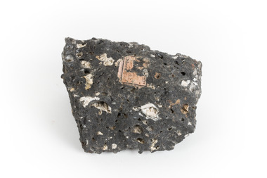
Geological specimen - Basalt, Unknown
Basalt is a common igneous rock that composes most of the Earth's surface and can be found on the Moon and other rocky planets of the Solar System. It is generally composed minerals such as calcic plagioclase, clinopyroxene and iron ore which form grains that are indistinguishable to the naked eye. It can be dark grey or black in colouring and sometimes may contain holes left by gas bubbles. Most of the Earth's basalt was produced in environments such as oceanic divergent boundaries, oceanic hotspots, and mantle plumes and hotspots beneath continents. Basalt is commonly used in construction where it is crushed and used for multiple purposes such as concrete aggregate, road base, or railroad ballast. Thin slabs of basalt can also be cut and used for floor tiles, stone monuments, and building veneer. This particular specimen was excavated from Talbot in Victoria, which was a small gold mining town established in 1852. As basalt is a common rock, it is not specific to Talbot. However, this specimen can be assumed to be of the Cainozoic age due to previous geomorphic surveys of the area. This particular type of Basalt was used mainly for roads due to the durability of the rock.Basalt holds significance due to the continued use of the rock from historic until present times. The rock has been utilised for many types of construction and is still used for the same purposes today. Basalt also has significance to the Earth and other rocky planets of the Solar System as it makes up most of the planet's surface. This specimen is part of a larger collection of geological and mineral specimens collected from around Australia (and some parts of the world) and donated to the Burke Museum between 1868-1880. A large percentage of these specimens were collected in Victoria as part of the Geological Survey of Victoria that begun in 1852 (in response to the Gold Rush) to study and map the geology of Victoria. Collecting geological specimens was an important part of mapping and understanding the scientific makeup of the earth. Many of these specimens were sent to research and collecting organisations across Australia, including the Burke Museum, to educate and encourage further study.A smaller than hand sized rock specimen which is dark grey in colour with small holes and white deposits across its surface.Geological survey / [illegible] /burke museum, beechworth, geological specimen, geology, basalt, basalt specemin, indigo shire, talbot, cainozoic, igneous rock -
 Warrnambool and District Historical Society Inc.
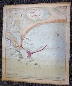
Map - Warrnambool Port 1879, 1879
The port facilities in Warrnambool Bay were in constant use from the first years of Warrnambool’s settlement but there were also difficulties for the shipping trade – a small and unsafe anchorage, the lack of loading facilities and little natural protection from the southerly gales. From the 1870s on there was local agitation for some sort of Breakwater to be built and an Andrew Kerr design was approved by the Warrnambool Council but no funds were made available from the Victorian Government. Throughout the 1870s the building of a Breakwater was a major political issue in the district with preliminary work being funded and started in 1874. In 1879 the Government agreed to a further inspection of the area and an official report. Sir John Coode (1816-1892) was commissioned to make this report. He had come to Australia in 1872 to advise on harbour construction. Coode recommended a 1800 feet long Breakwater and wharf connected to the shore and it was this proposal that the plan described herein and drawn up in 1879 was to accompany. The original plan was eventually modified because of the cost and a Breakwater was completed in 1890 under the direction of the engineer, Arthur Dudley Dobson, with extensions early in the 20th century. This plan is of great interest as it shows in simple graphic form the original plans proposed by Sir John Coode for the Warrnambool Breakwater. It is therefore of great historical importance. The Breakwater was not the maritime success that it was hoped it would be but it is today a significant feature of our foreshore. This is a Plan drawn up in 1879 by Victorian Harbours to accompany Sir John Coode’s Report on the proposed Warrnambool Breakwater. The chart detail is hand-drawn and hand-tinted on canvas with the names of places, geographical and marine features and local points of interest added in print. The edges of the chart are rubbed and the chart is somewhat faded and dirty but the main colours of red, green and brown are still clearly discernible. The title of the plan is printed in an oval inset at the top of the chart. The plan shows two possible Breakwater designs, one from the Borough Surveyor (Andrew Kerr?) and one from Sir John Coode.Victorian Harbours Warrnambool Plan to accompany Sir John Coode’s report Dated 28th Feby 1879 warrnambool breakwater, andrew kerr, sir john coode, arthur dudley dobson, warrnambool, warrnambool harbour, warrnambool history, warrnambool beach -
 Kiewa Valley Historical Society
Photograph - 8 Black and white photographs - SECV, Unknown
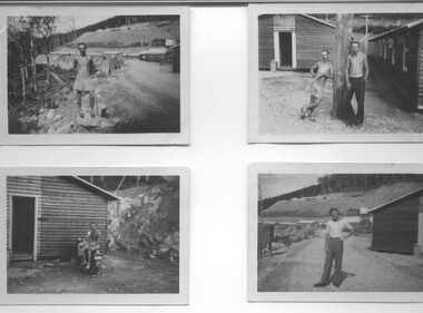
All eight photographs have been taken at a workmen's camp erected by the State Electricity Commission to house workmen during the construction of the Kiewa Hydro Electric Scheme. These were established in close proximity to various work centres - Junction Camp at Bogong Village, three camps at Mt. Beauty, West Kiewa, Clover Dam and Clover Flat, Howman's sawmill and Howman's Gap, Rocky Valley, Langford's Gap, Pretty Valley, Mountain Creek and Big Hill. These photos have not been identified as to which camp they are taken but typical of the type of accommodation for wages personnel. They followed a general design and layout. There was a mess and recreation hall as well as a building for general trading and postal facilities (this conducted by proprietors of trading stores in Mt. Beauty and Bogong). Originally the rooms accommodated 2 men but later there was a demand for single rooms - the floor size then being 10 feet x 8 feet and furnished with a bed, small table and chair and cupboard with hanging space. The first camps were erected in 1940 and the last was removed in 1962.These photographs are of historical significance as they show the type of accommodation provided for wages personnel working on the Hydro Electric Scheme between 1940 and 1960.Eight small black and white photographs of unknown person and workmen's camp.All photos have been stamped on the back - Two "965U" in red, four "S80 " in green (indistinct) and two "141" in red.workmen's camps, kiewa hydro electric scheme, accommodation, secv, camps on kiewa hydro electric scheme, west kiewa -
 Uniting Church Archives - Synod of Victoria
16 August 1988
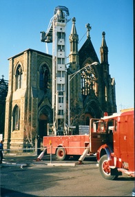
The foundation stone for the Cairns Memorial Church in East Melbourne was laid on 20 November 1882, and construction began in 1883 to a design produced by architects Reed, Henderson and Smart of Melbourne. The church was named in memory of the Rev. Dr. Adam Cairns (1802-1881), late pastor of Chalmers Church on Eastern Hill. Cairns was born in Scotland and ministered there until coming to Melbourne in 1853, where he served as a minister until 1876. The church in East Melbourne was intended to accommodate those who had seceded from Chalmers Church and formed themselves into a new charge. The original design for 'a handsome and commodious edifice in the early English Gothic style capable of seating 750 persons' was described and illustrated in The Australasian Sketcher (January 1883). The interior was to be octagonal in form, with the organ and choir placed in the southern transept. The first portion of the church was opened in November 1883, but was soon found, under the popular ministry of the Rev. G.D. Buchanan, to be too small for the congregation. A new design by the architects Twentyman and Askew was developed, and the first part of the redesigned building was opened on 5 October 1884. The completed building was opened on 17 April 1887. Built from Barrabool Hills stone with Waurn Ponds freestone dressings, it consisted of a nave and transepts, with raking floor, a substantial undercroft and the base of an incomplete tower and spire to the north-west. The church was gutted by fire in August 1988 and was subsequently redeveloped as an apartment complex. The congregation of Cairns Memorial now worships at Richmond-Collingwood, or at St. Michael's Collins Street. Colour photo showing the partial demolition of the Cairns Memorial Church in Powlett St. East Melbourne after it had been destroyed by fire on 15 August 1988.cairns memorial, dr adam cairns, chalmers church, powlett st. east melbourne, australasian sketcher, reed henderson smart, gothic style, presbyterian, twentyman askew -
 Uniting Church Archives - Synod of Victoria
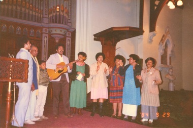
Photograph, 29 September 1984
The foundation stone for the Cairns Memorial Church in East Melbourne was laid on 20 November 1882, and construction began in 1883 to a design produced by architects Reed, Henderson and Smart of Melbourne. The church was named in memory of the Rev. Dr. Adam Cairns (1802-1881), late pastor of Chalmers Church on Eastern Hill. Cairns was born in Scotland and ministered there until coming to Melbourne in 1853, where he served as a minister until 1876. The church in East Melbourne was intended to accommodate those who had seceded from Chalmers Church and formed themselves into a new charge. The original design for 'a handsome and commodious edifice in the early English Gothic style capable of seating 750 persons' was described and illustrated in The Australasian Sketcher (January 1883). The interior was to be octagonal in form, with the organ and choir placed in the southern transept. The first portion of the church was opened in November 1883, but was soon found, under the popular ministry of the Rev. G.D. Buchanan, to be too small for the congregation. A new design by the architects Twentyman and Askew was developed, and the first part of the redesigned building was opened on 5 October 1884. The completed building was opened on 17 April 1887. Built from Barrabool Hills stone with Waurn Ponds freestone dressings, it consisted of a nave and transepts, with raking floor, a substantial undercroft and the base of an incomplete tower and spire to the north-west. The church was gutted by fire in August 1988 and was subsequently redeveloped as an apartment complex. The congregation of Cairns Memorial now worships at Richmond-Collingwood, or at St. Michael's Collins Street. Colour photo showing a group of Fijians singing to a guitar accompaniment in the apse of the Cairns Memorial Church East Melbourne.cairns memorial, dr adam cairns, chalmers church, powlett st. east melbourne, australasian sketcher, reed henderson smart, gothic style, presbyterian, twentyman askew, fijians -
 Uniting Church Archives - Synod of Victoria
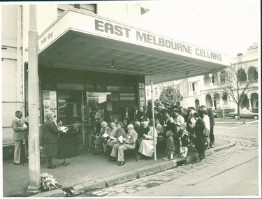
Photograph, 21 August 1988
The foundation stone for the Cairns Memorial Church in East Melbourne was laid on 20 November 1882, and construction began in 1883 to a design produced by architects Reed, Henderson and Smart of Melbourne. The church was named in memory of the Rev. Dr. Adam Cairns (1802-1881), late pastor of Chalmers Church on Eastern Hill. Cairns was born in Scotland and ministered there until coming to Melbourne in 1853, where he served as a minister until 1876. The church in East Melbourne was intended to accommodate those who had seceded from Chalmers Church and formed themselves into a new charge. The original design for 'a handsome and commodious edifice in the early English Gothic style capable of seating 750 persons' was described and illustrated in The Australasian Sketcher (January 1883). The interior was to be octagonal in form, with the organ and choir placed in the southern transept. The first portion of the church was opened in November 1883, but was soon found, under the popular ministry of the Rev. G.D. Buchanan, to be too small for the congregation. A new design by the architects Twentyman and Askew was developed, and the first part of the redesigned building was opened on 5 October 1884. The completed building was opened on 17 April 1887. Built from Barrabool Hills stone with Waurn Ponds freestone dressings, it consisted of a nave and transepts, with raking floor, a substantial undercroft and the base of an incomplete tower and spire to the north-west. The church was gutted by fire in August 1988 and was subsequently redeveloped as an apartment complex. The congregation of Cairns Memorial now worships at Richmond-Collingwood, or at St. Michael's Collins Street. B & W photograph showing the congregation of the Cairns Memorial Church attending a service held under the verandah of the East Melbourne Cellars (Cheers Bottle Shop) after fire had destroyed their church on 15 August 1988.cairns memorial, dr adam cairns, chalmers church, powlett st. east melbourne, australasian sketcher, reed henderson smart, gothic style, presbyterian, twentyman askew, fijians, east melbourne cellars, cheers bottle shop -
 Falls Creek Historical Society
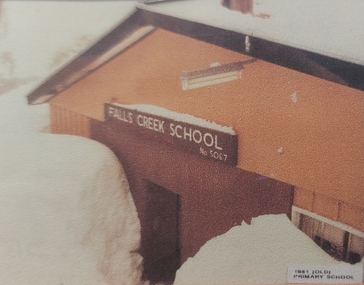
Photograph - Falls Creek Primary School
Falls Creek Primary School Prior to 1965, couples with small children would move away from Falls Creek due to there being no school facilities in the village. In the mid 60's a few families with school age children established themselves in the village, and a need arose for a school to encourage them to stay. An enrolment of seven children and a building was required before the Education Department could become involved. The Management Committee of the day gifted the families some land (still the site of the Falls Creek Primary School No. 5067) and fundraising began. The original committee consisted of the Steven family (two children), the Lee family (three children), the Caddie family (no children), the Carroll family (no children), and the Alston family (children?). After two years of community based, yet dubious fundraising methods (including weekly gluhwein parties, keg parties and numerous raffles), enough money ($1,300) was raised and an unused SEC building in Mt Beauty was bid on and won. Due to the condition of the road up to Falls Creek, it had to be dismantled and reassembled up the mountain. Unfortunately, the building was delivered to Falls Creek too late into the season to be erected but the following summer, with no money available to hire builders, working bees began, beer was on tap, and BBQs were cooked, and a crude schoolroom with an oil heater donated by Cecil Dobson from Winterhaven was erected. The first teacher hired was an Alaskan woman who agreed to a wage of $10 per child per week. Due to minimal resources the children were sent home at different times of the day in order to warm up and have a meal. Through the winter of 1971 many government departments were lobbied and it was decided that if the building could be finished to the Education Departments standards then they would provide a government endorsed full time teacher. The three main site holders (Bob Lee, Cecil Dobson and Dick Humphries) took out a loan and the school was refurbished and opened as the 'Bob Scott Memorial Hall' in time for the 1972 season. Maree Keele was the first Head Teacher. After three years of fund raising by the school committee the hall was paid off in full. After many years in the original building the Education Department took control of the school, updated the classrooms and provided accommodation for the teachers. In 1982, discussions began surrounding construction of a 'new' Falls Creek Primary School, a joint property with the community and the Education Department. After it was decided that the funds could not be raised fully by the community ($150,000), the Department constructed a new facility and students moved in on 1st July 1985.This image is significant because it represents the school which the Falls Creek Community fought to establish for their children.A framed coloured photo of Falls Creek Primary School under heavy snowIn lower right corner - 1981 Old Primary School Above doorway:- FALLS CREEK SCHOOL No. 5067falls creek primary school, fcps 5067, education falls creek -
 Falls Creek Historical Society
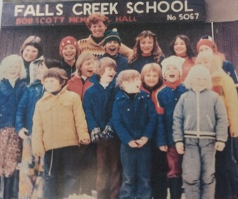
Photograph - Children at Falls Creek Primary School
Falls Creek Primary School Prior to 1965, couples with small children would move away from Falls Creek due to there being no school facilities in the village. In the mid 60's a few families with school age children established themselves in the village, and a need arose for a school to encourage them to stay. An enrolment of seven children and a building was required before the Education Department could become involved. The Management Committee of the day gifted the families some land (still the site of the Falls Creek Primary School No. 5067) and fundraising began. The original committee consisted of the Steven family (two children), the Lee family (three children), the Caddie family (no children), the Carroll family (no children), and the Alston family (children?). After two years of community based, yet dubious fundraising methods (including weekly gluhwein parties, keg parties and numerous raffles), enough money ($1,300) was raised and an unused SEC building in Mt Beauty was bid on and won. Due to the condition of the road up to Falls Creek, it had to be dismantled and reassembled up the mountain. Unfortunately, the building was delivered to Falls Creek too late into the season to be erected but the following summer, with no money available to hire builders, working bees began, beer was on tap, and BBQs were cooked, and a crude schoolroom with an oil heater donated by Cecil Dobson from Winterhaven was erected. The first teacher hired was an Alaskan woman who agreed to a wage of $10 per child per week. Due to minimal resources the children were sent home at different times of the day in order to warm up and have a meal. Through the winter of 1971 many government departments were lobbied and it was decided that if the building could be finished to the Education Departments standards then they would provide a government endorsed full time teacher. The three main site holders (Bob Lee, Cecil Dobson and Dick Humphries) took out a loan and the school was refurbished and opened as the 'Bob Scott Memorial Hall' in time for the 1972 season. Maree Keele was the first Head Teacher. After three years of fund raising by the school committee the hall was paid off in full. After many years in the original building the Education Department took control of the school, updated the classrooms and provided accommodation for the teachers. In 1982, discussions began surrounding construction of a 'new' Falls Creek Primary School, a joint property with the community and the Education Department. After it was decided that the funds could not be raised fully by the community ($150,000), the Department constructed a new facility and students moved in on 1st July 1985.This image is significant as it is representative of the children who have attended Falls Creek Primary School and their families who work to establish an education facility in Falls Creek.A coloured photo of a group of students gathered outside Falls Creek Primary School No. 5067 held in the Bob Scott Memorial Hall. Children in the photo include:- Phoebe Irwin, Paul Bryce, Sharon Purdue, Matthew Dobson, Tracy Lee, Danielle Humphries, Emma Brown, Kelly Bryce, Tim Scott, Megan Scott, Darren Spargo, David Spargo, Paul Costa, Adrian Costa, Luke (?) Spargo, Charlie Brownfalls creek primary school, bob scott memorial hall, education falls creek, fcps 5067 -
 Falls Creek Historical Society
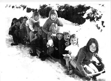
Photograph - Children outside Falls Creek Primary School, 1971
Falls Creek Primary School Prior to 1965, couples with small children would move away from Falls Creek due to there being no school facilities in the village. In the mid 60's a few families with school age children established themselves in the village, and a need arose for a school to encourage them to stay. An enrolment of seven children and a building was required before the Education Department could become involved. The Management Committee of the day gifted the families some land (still the site of the Falls Creek Primary School No. 5067) and fundraising began. The original committee consisted of the Steven family (two children), the Lee family (three children), the Caddie family (no children), the Carroll family (no children), and the Alston family (children?). After two years of community based, yet dubious fundraising methods (including weekly gluhwein parties, keg parties and numerous raffles), enough money ($1,300) was raised and an unused SEC building in Mt Beauty was bid on and won. Due to the condition of the road up to Falls Creek, it had to be dismantled and reassembled up the mountain. Unfortunately, the building was delivered to Falls Creek too late into the season to be erected but the following summer, with no money available to hire builders, working bees began, beer was on tap, and BBQs were cooked, and a crude schoolroom with an oil heater donated by Cecil Dobson from Winterhaven was erected. The first teacher hired was an Alaskan woman who agreed to a wage of $10 per child per week. Due to minimal resources the children were sent home at different times of the day in order to warm up and have a meal. Through the winter of 1971 many government departments were lobbied and it was decided that if the building could be finished to the Education Departments standards then they would provide a government endorsed full time teacher. The three main site holders (Bob Lee, Cecil Dobson and Dick Humphries) took out a loan and the school was refurbished and opened as the 'Bob Scott Memorial Hall' in time for the 1972 season. Maree Keele was the first Head Teacher. After three years of fund raising by the school committee the hall was paid off in full. After many years in the original building the Education Department took control of the school, updated the classrooms and provided accommodation for the teachers. In 1982, discussions began surrounding construction of a 'new' Falls Creek Primary School, a joint property with the community and the Education Department. After it was decided that the funds could not be raised fully by the community ($150,000), the Department constructed a new facility and students moved in on 1st July 1985.This image is significant because it includes children who became champion competitors at Victorian State, national and international level.A black and white photo of a group of children on a toboggan outside the Falls Creek Primary. It includes several future champion skiers. From back:- Kate Stevens, Pretty Valley Lodge, World Cup Freestyle representative and Champion; Tracey Lee, Attunga Lodge, Second in the Australian Freestyle and Australian Under Fifteen champion; Matthew Dobson, Winterhaven; Steven Lee, Attunga, three times Olympic and World Cup representative and competed on professional circuit; Chris Losch, Feathertop; Chris Heberle, Le Chalet, Cross Country Champion, eight times Australian Champion; Michelle Caddy, Geilo; Julie Smith: Vicki Losch, Feathertop: Debbie Humphreys, Powerhouse, Scott Caddy, Geilo: Sue Heberle, Le Chalet: Danielle Humphreys, Powerhouse, raced in State Championships and became ski instructor.falls creek primary school, falls creek education, falls creek skiers -
 Kiewa Valley Historical Society
Photographs – Bogong High Plains - Set of 16 black and white photographs mounted back and front on 3 pieces of heavy black card likely removed from a photograph album
After World War II, the Kiewa Hydro-Electric Scheme was started in the Kiewa River Valley by the State Electricity Commission of Victoria. On land previously used only for summer cattle grazing in the natural alpine grasslands, the first ski lodge was built in 1948 by workers from the hydro scheme as skiing was a popular recreation. Many of the hydro employees were of European background and had grown up enjoying skiing and snow sports in their homelands and were keen to continue to pursue their winter sports interests. The first lift, a rope tow, was built at Falls Creek in 1951 and the first chairlift in Australia was constructed there in 1957. Two T-Bars were opened in 1961. In 1964, the Victorian Municipal Directory recorded that Falls Creek had 29 ski club lodges and 16 commercial lodges. The area became a popular tourist destination for both winter and summer sports.Employees of the State Electricity Commission of Victoria in the Kiewa River Valley were the earliest skiers on the Bogong High Plains and built one of the first ski lodges at Falls Creek. They were amongst those pivotal in the development of the skiing and tourist industry at Falls Creek and on the Bogong High Plains. Black and white photographs of varying sizes mounted decoratively on heavy black Card. Some pages display a brief description printed in white ink 1. 4 photographs- displayed diagonally across page. 2 pictures of a group of men standing in the snow in front of a car with a loaded trailer behind. 1 photo of skiers. 1 photo of show hanging in tree branches. 2. 2 photographs- showing Upper Kiewa Road with snow in the background 3. 3 photographs- of skiers and 1 photo of 2 of men posing in the snow & 1 photo of 2 men posing shirtless in warmer weather. 4. 2 photographs- arranged diagonally on page showing early buildings and construction at Bogong Village 5. 2 photographs- 1 showing view of Bogong Village from higher up the mountain. 1 showing early Bogong High Plains road 6. 1 photograph- showing view down along Kiewa Valley from higher up in the mountains 1. Handwritten in white ink – A TRIP TO THE PLAINS 2. Handwritten in white ink – UPPER KIEWA ROAD MT FAINTER IN BACKGROUND 3 – 6. No markings bogong village; upper kiewa road; bogong high plains; falls creek; skiers -
 Bendigo Historical Society Inc.
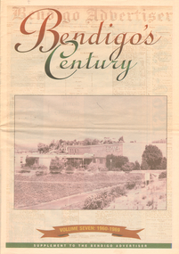
Newspaper - LONG GULLY HISTORY GROUP COLLECTION: BENDIGO'S CENTURY VOLUME SEVEN: 1960 - 1969
Supplement to the Bendigo Advertiser, December 15, 1999 Volume Seven: 1960-1969 titled Bendigo's Century. The front has a photo of the BCV 8 Studio. Contains photos and local news, council matters, planning, Who's Who, Weather, Sport and Business and some Advertisements. Photos include Early stages in the construction of the Eppalock tower and bridge pillars, Christine Wiseman, TV8's first news reader Ron Alderton, Dr Albert L Beischer, Advertiser buiding, fire at the Advertiser building, Oscar Flight, Bendigo Town Hall, William Basil Ashman, Lake Eppalock, Premier Henry Bolte, Que O'Hoy, Sandhurst Guest House, The Lyric Theatre, E C Thompson, The elm tree in Market Square, Leslie Galvin, The original Myer Store, The Joss House, Sidney Myer, Bendigo Police Barracks, Bunratty Castle, Albert Vivian Gray, The Victoria Hill site, Architects drawing of the new council administrative offices and Noel Beaton MHR.bendigo, history, long gully history group, the long gully history group - bendigo's century volume seven: 1960 - 1969, bendigo advertiser, bcv 8, eppalock dam, premier henry bolte, the criterion hotel, mccarthy family, teachers training college, bendigo original teachers college, long gully state school, stramit, bendigo university site committee, mrs christine wiseman, bendigo city council, the broadcasting control board, general television pty ltd, bendigo central victoria telecasters pty ltd, mr davidson, bennett's arcade, woolworth's, white hills swimming pool, herb elliott, sailor's guide, toni riley pharmacies, rising sun hotel, ron alderton, dr albert l beischer, channel 8, melbourne herald, 3bo, bendigo advertiser officeslyceum theatre, junior technical school white hills, mount alvernia hospital, most reverend dr b d stewart, sisters of the franciscan missionaries of the divine motherhood, lazarus family, bendigo's tramways, state electricity commission, george pethard, lance pethard, bendigo advertiser fire 29/7/1962, riverine herald, the herald and weekly times, bendigo art gallery, oscar flight, hollands foundry, eaglehawk u.f.s. dispensary, gillies famous pies, william basil ashman, golden gate hotel, grieves family, bendigo town hall, mr r r anderson, mr e h brown, cr neville oliver, cr tom flood, traffic commission, lansell family, abev-1, bendigo ordnance factory, actu, bendigo trades hall council, the ramsay report, bendigo benevolent home, bendigo home and hospital for the aged, princess theatre, amoco, lake eppalock, bendigo training prison, bendigo police station lock-up, shamrock hotel, rifle brigade hotel, hopetoun hotel, anz bank, marong shire offices, sir rohan delacombe, st paul's church, que o'hoy, waldron family, windermere hotel, aids & appliance shop, anne caudle centre, e c thompson, mayfair hams, sandhurst guest house, lyric theatre, chinese joss house, ordnance factory, sir john jenson, bridge street chinese quarter, bendigo city hall, cr r f turner, cr tom flood, victorian inland meat authority, new zealand insurance co, mrtropolitan security service, bendigo easter fair society, golden square high school, eaglehawk high school, bendigo technical college, mr ralph w birrell, bendigo fountain plaza, the bethlehem home for the aged, dick hazeldene, victorian egg board, bendigo united cricket club, south bendigo united cricket club, western mining corporation, les priest, alexandra fountain, bendigo advertiser, cr w cambridge, bendigo council, eaglehawk council, strathfieldsaye shire, huntly shire, marong shire, david thomas, senator john gorton, bendigo's college of advanced education, bank of new south wales, harp and shamrock hotel, the honorable leslie william galvin, kurmala, cain government, hanro knitting mills, myer store, sidney myer, davey brothers grocery store, national trust, myer emporium, myer's ltd, cox bros (australia) ltd, dame merlyn myer, baillieu myer, frank greenaway, institute of technology, gas & fuel corporation, bendigo railway station, anz bank, city family hotel, tab branch, senior constable alfred herbert wright, senior constable allan raymond brown, victorian football league, bendigo police barracks, camp hill state school, state electricity commission, the country party, the labor party, transport regulation board, stuart anderson, grose family, jean theodore de ravin, kyneton shire, sir william mcdonald, mines department, the loddon hospitals region group laundry and central linen service, kevin wynne, albert vivian gray, bradford cotton mills ltd, bradmill industries ltd, victoria hill, bendigo and district tourist association, professor brian lewis, melbourne university, victorian chinese community, loong, sun loong, stafford ellinson, coles' store, north deborah mining company nl, noel beaton mhr, durham ox hotel, taylor family -
 Ballarat Tramway Museum
Photograph - Leaf from a photo album, 1920s
Leaf from a photo album containing 4 black and white photographs pasted onto sheet of brown/grey cardboard with two punch holes at one end. Photos taken early 1920's or just after construction of the Memorial Arch. Photo 1 - "Ballarat" handwritten in pencil at top - Town Hall from the North West taken from a building near Doveton St. Has a Sebastopol tram west bound in Sturt St. passing Town Hall. Photo 2 - "Sturt Street Ballarat" handwritten in pencil at base - Sturt St. Ballarat looking east from most likely the Ballarat City fire station lookout tower. Has a Sebastopol tram travelling eastbound in the photograph. Town Hall in background. No motor vehicles in photograph. Photo 3 - "Memorial Arch, Ballarat" handwritten in pencil at top - photo of the new Memorial Arch at the start of the Avenue of Honour. Photo 4 - "Eureka Stockade, Ballarat" - photo of the Eureka Stockade monument the park.trams, tramways, ballarat, sturt st, memorial arch - avenue of honour, eureka -
Kew Historical Society Inc
Archive (Sub-series) - Subject File, Buildings (Kew), 1964
Various partiesReference, Research, InformationSecondary Values (KHS Imposed Order)Subject file containing newspaper articles/clippings, research and correspondence from and to the Society. The earliest item, dating from 1964 is a letter from the Society to the City of Kew seeking Council support for the use of Ellesmore, 80 Princess Street as a cultural heritage centre. Other items of correspondence relate to the Masonic Hall (Walpole Street), Fernhurst, Southesk, Roberts House, Park Hill, Butleigh Wooton, Villa Alba, D’Estaville, Charleville, Roseneath, Merridale, La Verna, Otira, Raheen, Willsmere, Holy Trinity Church. Some of these letters contain information about construction of the buildings and architects. In addition to this correspondence, the file includes brief undated research notes on the Clock Tower at the Kew Cemetery, Tarring, Southesk, the Alexandra Gardens, Studley House (Burke Hall), Ellesmore, the Masonic Hall, Xavier College, Genazzano, Trinity Grammar, Carey Baptist College, Abbotsford, Fernhurst, Illapa, Madford, Morganville, Otira, Parkhill, Monnington, Field Place, Lalla Rookh, Merridale, Kew Mental Hospital, and D’Estaville.buildings -- kew (vic.), heritage -- kew (vic.)buildings -- kew (vic.), heritage -- kew (vic.) -
 Kew Historical Society Inc
Plan - Subdivision Plan, Raheen Estate Subdivision, 1960
Subdivision plans are historically important documents used as evidence of the growth of suburbs in Australia. They frequently provide information about when the land was sold on which a built structure was subsequently constructed as well as evidence relating to surveyors and real estate and financial agents. The numerous subdivision plans in the Kew Historical Society's collection represent working documents, ranging from the initial sketches made in planning a subdivision to printed plans on which auctioneers or agents listed the prices for which individual lots were sold. In a number of cases, the reverse of a subdivision plan in the collection includes a photograph of a house that was also for sale by the agent. These photographs provide significant heritage information relating house design and decoration, fencing and household gardens.The Raheen Estate Subdivision of 1960 involved the creation of 36 residential allotments and the sale of 34 of these. The land on which the subdivision was created had until 1960 formed part of the grounds of the mansion Raheen in Studley Park Road. In 1917, the Catholic Church had purchased Raheen and its lands. It was to become the home of Archbishop of Melbourne, Daniel Mannix, for 46 years. The sale of the subdivision took place three years before the Archbishop’s death. Subsequent archbishops were to reside at Raheen until its sale to the Pratt family in 1981. When the sale of the Estate was reported in the newspapers in 1960, it was described as the last big subdivision near Melbourne. At the auction, 33 of the 36 allotments were sold. The auction realised £315,750. Purchasers were advised that the vendor intended to keep lots 22 and 23. The alllotments in the subdivision required the construction of new roads. These included Eamon Court and Raheen Drive. The justification provided by the Church for the sale was that the estate was being sold to finance school building projects.subdivision plans - kew, studley park, raheen estate, eamon court, studley park road, coombes avenue, raheen drive -
 Bendigo Historical Society Inc.
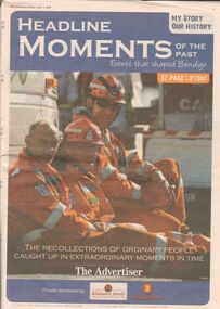
Newspaper - THE ADVERTISER: FRIDAY JULY 3, 2009 HISTORY-EVENTS THAT SHAPED BENDIGO 32 PAGES, 1881
Headline Moments of the Past The Advertiser, Friday July 3, 2009 History - Events That Shaped Bendigo 32 Page Supplement. Newspaper supplement includes images and articles as diverse as the construction of Alexander Fountain in 1881, The Great Depression 1930s, End of World War II 1945, CBD Floods 1949, Queen Elizabeth's Visit 1954, Olympic Games (Melb) and first television in Bendigo 1956, Bendigo farewells local champion horse 1958, Demolition of verandahs on local buildings 1960s, opening of Eppalock 1964, The Vietnam War 1965-1975, The new dragon Sun Loong 1970, The last tram run and Faraday kidnapping 1972, opening of Sacred Heart Cathedral 1977, opening of Hargreaves Mall 1982, Killians Walk Fire and Gaol Siege 1987, Local government Amalgamation 1993, Opening of Marketplace and Discovery Centre 1995, Restoration of Rosalind Park Cascades 1997, Bendigo Tornado 2003. This publication has not been scanned.bendigo, history, bendigo advertiser, alexander fountain construction 1881, bendigo cbd floods 1949, dmolitition of bendigo building verandahs 1960s, last tram run 1972, killians walk fire 1987, bendigo tornado 2003 -
Port of Echuca
Audio - Oral History - Geoff Evans, Oral History of Geoffrey Thomas Evans of Echuca b1924 d 2007, 2002
Geoff Evans was the third generation to run Evans Brothers Sawmills that operated from the northern end of the Echuca Wharf from 1923 to 1983. His grandfather Richard James Evans orig. of England, settled in Victoria at a young age. He first worked as a butcher and later cut firewood in the Heathcote and Bacchus Marsh area. ‘R.J.’, as he was known established a sawmill at Barmah in the 1890s, before relocating to this site in 1923. It became known officially as the Evans Bros. Echuca Red Gum Sawmill. This site proved more economical due to its position at the railhead. Paddlesteamers towed barges carrying the logs from the surrounding forests to this mill. The Steamers that were owned by the Evans family were the Edwards (built 1875) and the Melbourne (built 1912). The Edwards was the main towing vessel. Outrigger barges at this mill were the Impulse (1885), Alison (1907), Clyde (once a paddlesteamer, built in 1884). Insider barges at the mill were old wool barges with iron topsides, the J.L.Roberts (1894), ADA (1899) and the Whaler which was of wooden construction. The Evans Mill cut both red gum and Murray pine. There was a main mill for the red gum and a second one for the pine on this site. Two new Marshall steam engines had been purchased by the family, one was used in the P.S. Edwards and the other for the Barmah mill and later this site. The Evans Bros. Mill was very much a family concern with it being owned and operated firstly by R.J., then his son Frederick. R. Evans and later grandson Geoff Evans. The mill employed 18 workers and operated until the 1980s, only briefly was it in the hands of other owners before the construction on part of the site of a tourist-oriented building known as the Red Gum Works which eventually made way for the Port of Echuca Discovery Centre in 2014.Knowledge of the redgum timber milling industry and associated mechanisms such as log slips is scant with little photographic representations to be found. The industry created alongside the Murray River in various places was very unique given the nature of red gum not floating and ingenuity and making use of local resources was required. Geoff Evans had firsthand knowledge of much of this process and how the Echuca Wharf area used to be in past decades. Geoff was also a popular musician and mayor of Echuca so had much knowledge of the local history and community.Digital recording of oral history interview with Geoff Evans of Evans Brothers Sawmill Echuca. evans bros, evans bros saw mills, evans' sawmill, geoff evans, log slip, log skid, p.s. edwards, p.s. melbourne, impulse barge, allison barge, clyde barge, j.l. roberts barge, ada barge, whaler barge, murray pine, redgum, marshall engines, r.j evans, f.j. evans, discovery centre, p.s. marion -
 Melton City Libraries
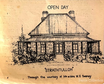
Drawing, Open Day at Strathtulloh, Unknown
"Strathtulloh, 1402-1600 Greigs Road, Melton South, is significant as an early property in Victoria, retaining different eras of pioneering dwellings, ranging from a ruin to a fine Colonial style homestead. The property has close historical association with the early settlement of the Melton district, and was owned by the Henty family in the 1840s. The Strathtulloh property was alienated by the Crown in 1840 to Charles James Garrard, who sold it in 1848 to Charles and Stephen Henty, whose sister Jane and her husband Samuel Bryan lived there in the late 1840s. In 1853 the property then passed to William Tulloh, after whom the homestead was named. A primitive bluestone ruin of near the Toolern Creek, built of vesicular bluestone and mud mortar, is of unknown origin. It has commonly been assumed to pre-date 1840, and to have belonged to the original holder of the Exford lease, Dr Watton or Port Phillip Association member Dr Cotterill. This is unlikely, as the 1841 census records Dr Watton, and everyone else in the district, as living in a ‘wood’ dwelling. It may instead have been the residence of Garrard, and the Bryans, in the 1840s and an early map names a site near here as ‘Bryan’s outstation’. It is assumed that the two-level stone building that became the kitchen is the earliest intact building on the site, and was the first homestead; it is likely to date to the 1840s or 1850s. The main homestead is a substantial villa constructed of random coursed bluestone, with a verandah facing three sides, attic bedrooms with dormer windows, a fan light over the front door, a hipped roof originally clad in slate, and a large cellar. Although demonstrating characteristics of pioneering construction, such as unworked log beams, pit sawn beams, hand-sawn lintels and colonial door locks, documentary evidence shows that it was built c.1869. The homestead has now been structurally repaired and decoratively restored; a sympathetic new semi-detached rear extension was added in the early years of the 21st century. The former kitchen building has also undergone minor repairs and alterations". Strathtulloh Homestead at 1402-1600 Greigs Road, Melton Southlocal architecture -
 University of Melbourne, Burnley Campus Archives
Album - Black and white and colour slides, Burnley Views, 1947-1955
Contributor: T.H. KneenCardboard box of 108 35mm glass slides in metal frames made by "Gnome." Box labelled "Burnley Gardens Slides." Also 16 unused slides (1) Swan Street entrance c. (2) Orchid? b/w. (3) Nursery b/w. (4) Pasture area with man working b/w. (5) Draught horse working in the Orchard b/w. (6) Crop of corn in the Orchard c. (7) Magnolia c. (Magnolia x soulangeana). (8) Display of orange flowers c. (9) Lemon tree in the Orchard c. (10) Sign advertising 'Fruit Tree Pruning Demonstarion Sat. 2nd July (1949) c. (11) Jersey cow c. (12) Rock Point c. (13) Dahlias in the Orchard c. (14) Foundation Stone '28th August, 1946' c. (15) Felled Cypress tree 1951 b/w. (16) School truck in front of glasshouses and cacti b/w. (17)Administration Building completed but surrounded by rubble C.1949 c. (18) Plant Research Institute c. (19) Inside a glasshouse. c. (20) Administration Building c. (21) Group of female students dressed up for a function c. (22) Solenostemon (Syn. Coleus) in a glasshouse. (23, 24)Stock Matthiola incana. (25) Blossom in the Orchard c. (26) Orchard c. (27) Picking fruit in the Orchard c. (28) 2 female students holdong large bunches of poppies c. (29) Flowers growing in the Orchard c. (30) House - not Burnley c. (31) Students on an excursion c. (32) Staff member with Gladioli c. (33) Garden view - not Burnley? c. (34) Administration Building c. (35) Roses c. (36) Flowers in the Orchard c. (37) Draught horse working in the Orchard c. (38) Staff member amongst flowers in the Orchard c. (39) Garden view c. ((40) Blossom in the Orchard c. (41) Orchard c. (42) Flowers inside glasshouse c. (43) Mesembryanthemums in pots possibly in the nursery c. (44) Tree b/w. (45) Garden bed c. (46) Sign, 'Agrostology Branch, pasture Plant Research Field,' c. (47) Path to Principal's Residence c. (48) Irrigation in the Orchard b/w. (49) Cactus flowers b/w. (50) Garden view with T.H. Kneen children playing c. (51) (52) Cinerarias (now Pericallis x hybrida) in pots c. (53) Temporary building where the Grey Garden is now b/w. (54) Garden view b/w. (55) Unknown building b/w. (56) Person pruning in the Orchard c. (57) Students working in the Orchard c. (58) Swan Street with recently completed rock wall constructed by the Public Works Department b/w. (59) Lagoon paddock b/w. (60,62) Pavilion and new Administration Building before the Pavilion was removed b/w. (61) As (60) but viewed from a different direction c. (63) Plant c. (64) View through a window on the stairs in the Administration Building c. (65) Plant c. (66) Garden view of trees c. (67) Garden View b/w. (68) Blossom tree c. (69 )Garden view along path to Principal's Residence c. (70) Lagoon Paddock c. (71) Lagoon Paddock with cows b/w. (72) Inside a glasshouse b/w. (73) Entrance sign- Department of Agriculture Burnley Gardens, School of Horticulture & Primary Agriculture, Plant Research laboratory, Agrostology Branch, Fruit Preserving Branch c. (74) Plant Research Laboratory b/w. (75) Students on an excursion c. (76) Glasshouses b/w. (77) Garden view b/w. (78) Kniphophia c. (79) Hibiscus c. (80) Garden view c. (81) Dairy, Silo and dog b/w. (82) Irrigation in then Orchard b/w. (83) Garden view with magnolia c. (84) Flower plots in the Orchard c. (85) Pruning demonstration b/w. (86) Administration Building under construction c. (87) Rock Point c. (88) Mrs Kneen and Magnolia c. (89) Glasshouses c. (90) Sequoia sempervirens b/w. (91) Inside Administration Building c. (92) Luffmann Ponds b/w. (93) Sequoia sempervirend, Mrs Kneen and child c. (94) Garden bed in front of Sequoian sempervirens c. (95) Principals Residence b/w. (96) Poultry pens b/w. 1947 (97) Principals Residence b/w. (98) Student picking fruit from netted tree b/w. (99) Rock Point and Long Border c. (100) Administration Building under construction c. (101) Greenhouse b/w. (102) Rock Point c. (103) Flowers in the Orchard c. (104) Waterlilies in the Pond c. (105) Blossom tree c. (106) Hilda Kirkhope Rockery c. (107) Long Border c. (108) Plant Research Institute with flower border along drive c.burnley gardens, flower, nursery, pasture, draught horse, orchard, crops, magnolia, chicken coops, egg laying competition -
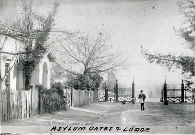 The Beechworth Burke Museum
Photograph - Photograph Reproduction, 1890
The photo is taken in 1890 and a man is depicted, entering the main gates of the Mental Hospital at Beechworth, with the lodge on his right side. The man is dressed according to the australian fashion of that time, wearing a dark suit and a top hat. The countryside surrounding the Hospital is in the background. The Mayday Hills Hospital was constructed between 1864 and 1867, with buildings created in a number of periods. It formally opened on 24 October 1867 and, along with the Ovens Hospital and the Benevolent Asylum, made Beechworth a prominent social welfare centre in Victoria. The need for an institution of this kind was arisen due to the increased number of people with mental disturbances (induced by the harsh living conditions on the goldfields) and the remoteness of the district from Melbourne. The site was chosen for its panoramic view of the countryside, the hilltop atmosphere and the native fauna, all contributing to the cure of patients. It was designed in Italianate style and around 250 workmen were employed for its construction. The Hospital was originally named the “Ovens Lunatic Asylum” but, during the centenary celebrations in 1967, the name was officially changed to “Mayday Hills Hospital”, showing the gradual shift in the perception and understanding of mental health conditions over the last decades. The Hospital lies on the traditional land of the Kulin Nation.This photograph is historically significant as it provides an insight into the location, surroundings and the exterior of the Mayday Hills Hospital at the end of the 19th century. It also contributes to the understanding of the district`s development and its importance to the course of Victoria`s history. Moreover, it adds information to the scientific research and the way mental health conditions were treated at that time.Black and white rectangular photograph printed on paper unframed.Obverse: Asylum Gates & Lodge/ Reverse: 3451-1/mental hospital, beechworth, australian fashion, dark suit, top hat, countryside, mayday hills hospital, ovens hospital, benevolent asylum, institution, mental disturbances, social welfare, living conditions, goldfields, workmen, italianate style, kulin nation, mental health, ovens lunatic asylum, patients