Showing 33231 items matching "buildings/streetscapes"
-
![Newspaper - Newspaper Clipping - Digital Image, The Valley Voice, [Main Street Greensborough 1978], 08/11/1978](/media/collectors/4f729f5697f83e03086015b8/items/674ab0558f48af8ae71d31f3/item-media/674ab0778f48af8ae71dca42/item-fit-380x285.jpg) Greensborough Historical Society
Greensborough Historical SocietyNewspaper - Newspaper Clipping - Digital Image, The Valley Voice, [Main Street Greensborough 1978], 08/11/1978
Main Street Greensborough 1978 showing the streetscape and trafficDigital copy of newspaper articlegreensborough plaza, main street greensborough -
 Sunbury Family History and Heritage Society Inc.
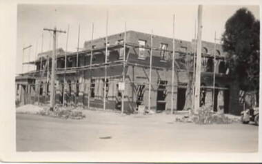
Photograph, Royal Hotel, 1936
The two storey building under construction is the Royal Hotel. The larger building replaced the former single storey hotel which was built on the same site in 1861. The new building is a red brick structure.A non-digital black and white photograph with a cream border of a two storey brick building under construction and surrounded by scaffolding. royal hotel, evans street, brook street, hotels -
 Beaufort Historical Society
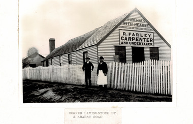
Photograph - Beaufort Business, R Farley Carpenter and Undertaker
Photograph of R Farley Carpenter and Undertaker, late 1890's. Building was at south-east corner of Livingstone and Neil streets Beaufort. Black and White photograph of Farley's Building with 2 people outsidebeaufort business, beaufort -
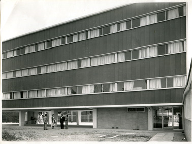 International House, The University of Melbourne
Photograph (item), Australian News and Information Bureau, Newly constructed Ian Clunies Ross building at International House Melbourne, 1957
This building was the first residential housing for the newly established International House in Melbourne, which had been in its planning stages since 1954. The building housed both domestic and international students.residential college, international house, architecture -
 Frankston RSL Sub Branch
Glass, Souvenir
A pair of small wine glasses, perhaps sherry glasses. These glasses have the image of the new Frankston Returned & Services League of Australia club building and were made for the 1st anniversary of the opening which was celebrated in 1977. These glasses are made from clear glass and are embellished in gold leaf, the glasses are gold lipped.The glasses are inscribed with the following in gold leaf: "1st ANNIVERSARY 1977" and the image of the new club building with the words "FRANKSTON RSL". -
 Bendigo Military Museum
Photograph - Lithographic Squadron Building Upgrades - Army Survey Regiment, Fortuna, Bendigo, 1990
This is a set of 11 photographs of Lithographic Squadron Building Upgrades at the Army Survey Regiment, Fortuna, Bendigo. 1990. These upgrades performed by Litho personnel occurred at around the same time as the construction of Lithographic Squadron’s new Printing Building. This is a set of 11 photograph of Lithographic Squadron building upgrades at the Army Survey Regiment at Fortuna, Bendigo, 1990. The photographs were on 35mm negative film and were scanned at 96 dpi. They are part of the Army Survey Regiment’s Collection. .1) and .2) - Photo, colour, 1990, building construction. .3) - Photo, colour, 1990, building modifications, L to R: Dale Hudson, WO2 Keith Fenton RE. .4) - Photo, colour, 1990, building modifications, L to R: Roy Hicks, Lance Strudwick, Dale Hudson, Ian Nicholls, Gary Lord, Kim Reynolds, Peter Swandale (rear), Gavin McLean, Andrew Arman, Graham Spong, Mark McCullough. .5) - Photo, colour, 1990. building modifications, L to R: Ross Anza, unidentified, Damien Cole. .6) and .7) - Photo, colour, 1990, Old proofing hut. .8) - Photo, colour, 1990, building modifications, Brian Fauth. .9) - Photo, colour, 1990, building modifications, L to R: Roy Hicks, Brian Fauth. .10) - Photo, colour, 1990, building modifications, L to R: Peter Swandale, Gary Kerr, Ian Nicholls, Brian Fauth, Roy Hicks. .11) - Photo, colour, 1990, building modifications, L to R: Peter Swandale, Gary Kerr, Brian Fauth, Ian Nicholls, Roy Hicks. No personnel are identified. royal australian survey corps, rasvy, army survey regiment, army svy regt, fortuna, asr, litho -
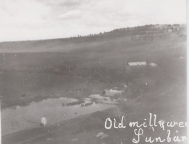 Sunbury Family History and Heritage Society Inc.
Photograph
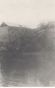
The former mill and weir shown in the photograph were sited on the banks of Jacksons Creek downstream from the town of Sunbury. John Eadie, a Scottish immigrant established the water-driven flour mill on the banks of the creek after he arrived in the colony in 1866. The mill continued operating until the outbreak of World War 1 when the metal wheel and iron roofing were taken and used for the war effort. The hill in the back ground with the trees and buildings was the site of the former Sunbury Asylum. Milling was one of Sunbury's early industries that were established in the district.A black and white photograph of a building and a lake in a valley. Buildings and trees are visible on a distant hillside.sunbury flour mill., milling -
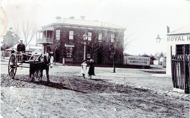 Sunbury Family History and Heritage Society Inc.
Photograph, Rupertswood Hotel
The photograph was taken at the intersection of Brook and Evans Streets in Sunbury. The two storey bluestone building was the Rupertswood Hotel, which was on the NE corner of the intersection and the single storey Royal Hotel building in the foreground was on the opposite corner. The Millett family originally owned both hotels. The Rupertswood Hotel was demolished in December 1974 to make way for a modern retail store. In 1939 the old Royal Hotel building was damaged by fire and replaced with a two storey red brick building.The Rupertswood and Royal Hotels were two of the earliest hotels to be erected in the Sunbury township.A non-digital black and white photograph of a street photograph featuring an intersection with a two storey bluestone building on one corner and a partial view of a single storey rendered building on the opposite corner. Two children are standing on the side of the road and a man is in a horse-drawn jinker. george millett, royal hotel, rupertswood hotel, evans street, brook street, hotels -
Glenelg Shire Council Cultural Collection
Photograph - Photograph - Portland Butter Factory, M. E. Andrews, n.d
The Portland Butter Factory opened in a new building 1935 on the Heywood Road. The opening of the building was attended by K. S. AndersonBlack and white photo of the Portland butter factory. Timber building, split level, large brick tapered chimneyBack: 'Butter Factory Portland' - handwritten in black ink Round purple stamp 'PRINTED BY M.E. ANDREWS PORTLAND'portland industry, dairy, trade -
 Mission to Seafarers Victoria
Photograph - Photograph, Black and white, c. 1945
The building is clearly what is now known as the Mission to Seafarers, however there seems to be a sign on the building describing it as the Mission to Seamen. Depicts actual road outside the Mission, Flinders st which seems to still be undeveloped with wooden? drainage covers still in place suggesting a period for the photograph circa late 1930s to the immediate post WW2 era.The image is part of the century long record of the central location of the Mission at 717 Flinders St. Black and white photograph depicting the Flinders Street building circa 1945. victoria-missions-to-seamen, melbourne-missions-to-seamen, cottage, windvane, flinders street -
Whitehorse Historical Society Inc.
Article, Back to school - making history
Back to school - making history.Back to school - making history. Vermont Primary School original building restored. With photo.Back to school - making history.primary schools, vermont primary school, no. 1022, harradine, david, griffin, suzanne -
Clunes Museum
Film - DVD, Nine Network Australia, Postcards - Episode 22, 2008, 2008
Visual programme featuring Widow Twankey's. a local cafe, and the Clunes Museum prior to the redevelopment of the site at 36 Fraser Street, in 2012. Interviews of Tim Hayes, owner of Widow Twankey's and Pat Cook the Curator of Clunes Museum. Images of significant sites and historic buildings as well as streetscapes and landscapes of Clunes.DVD IN WHITE PAPER SLEEVE CHANNFEL 9 POSTCARDS, EPISODE 22 "GENERAL SHOW"widow twankey's, pat cook, tim hayes, clunes museum -
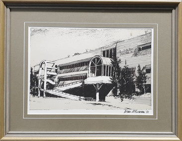 Federation University Historical Collection
Print - Image, Brian McLennan, Ballarat School of Mines M.B. John Building, 1990, 1990
... buildings ...In 2017 the front arch stairs were demolished to make way for the repurposing of the building into the Ballarat Technical School. Framed image of a drawing of the M.B. John Building Albert Street frontage.Signed 'Brian McLennan '90"m.b. john, morgan b. john, morgan bevan john, ballarat school of mines, albert street, brian mclennan, buildings, m.b. john building -
 Ballarat Heritage Services
Photograph - Photograph - Colour, Blythwood Grange (Formerly St Joseph's Orphanage), 2012, 21/04/2012
The foundation stone for this building was laid by the Most Reverend Dr Higgins, Bishop of Ballarat, on 08 September 1911. Colour photograph of a brick building of the former St Joseph's Orphanage, Sebastopol. sebastopol, st joseph's orphanage, blythwood grange -
Marysville & District Historical Society
Document (Item) - Information document, Victorian Bushfire Reconstruction and Recovery Authority, Marysville - Murchison Street and Town Amenity Project, 2010
A document outlining the re-building and re-development of Murchison Street in Marysville in Victoria.A document outlining the re-building and re-development of Murchison Street in Marysville in Victoria.marysville, victoria, 2009 black saturday bushfires, murchison street -
 Federation University Historical Collection
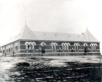
Photograph - black and white, Golden Point State School No. 1493
The Golden Point school building was started in 1874 and opened on 11 January 1875. Photograph of a brick building with slate roof and bluestone foundations at Golden Point, Ballarat.Below photo 'State School No. , Ballaarat, Golden Pt. Richards Photo, Ballarat - Education Dep. Vict.'golden point, education, school -
 Sunbury Family History and Heritage Society Inc.
Photograph
The large building is a former mill which was sited along the Jacksons Creek in Sunbury.Milling along with vineyards was one of the early agricultural pursuits carried out in the former Bulla Bulla district.A black and white photograph of a large stone building built on a rise above a pond.jacksons creek, mills -
 Vision Australia
Photograph - Image, St Kilda Road building in 2010, 6/1/2010
... Buildings ...In 2007, Vision Australia sold it's iconic 557-563 St Kilda Road site. The historic bluestone building was in need of renovation and repair, had limited space for staff and clients and with more demand for services in suburban and regional areas, did not meet the needs of the national organisation. The purchaser was mainly interested in the Ormond Hall section, which they sub-divided off and sold to the tenant of the Belgian Beer Cafe. The remainder of the site was then sold on to another developer. Unable to quickly proceed with their plans on developing the site for residential buildings, the site fell into some disrepair in the interim which was when these images were taken. Later the site was sold again and residential buildings now occupy part of the block. 20 images taken of and from St Kilda Road buildingroyal victorian institute for the blind, buildings, myer house, ferguson and urie -
 Eltham District Historical Society Inc
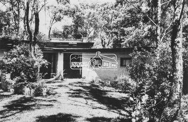
Photograph, Sonia Skipper - Joe Hannan House (1948)
Image 10 Sonia Skipper - Joe Hannan House Commenced 1948 for Professor Max and Jenny Tiesmann Built by Horrie Judd, altered and extended by Sonia Skipper The Alistair Knox Collection The Alistair Knox Collection is a series of mounted enlarged photos of mud brick houses and related subjects. The collection is understood to have been put together by Alistair Knox although it is the work of several unacknowledged photographers. For some years it was held by the Building Department of the former Eltham Shire Council and was then passed to our Society for safekeeping. Some of the photos have been used in Knox's books and from time to time some of them have been part of various historical displays. As far as we know there has not been a public display of the whole collection which numbers about forty photographs. The collection has been copied on to slides for the purpose of this meeting and to be retained as part of the Society's pictorial collection. Alistair Knox 1912 - 1986 is acknowledged as the founder of Eltham's mud brick building movement. Many of the buildings shown in the collection are of his design and he was also involved with the construction of several of them. Others are the work of his contemporaries and associates such as Peter Glass, Gordon Ford, and John Harcourt. (EDHS Newsletter No. 145 July 2002)Handwritten notes in pencil re details of building, year of construction, owner, designer, builder, etchorrie judd, houses, jenny tiesmann, mud brick construction, professor max tiesmann, sonia skipper, sonia skipper - joe hannan house, alistair knox collection -
 Eltham District Historical Society Inc
Photograph, Periwinkle House (1948)
Images 9A 'Periwinkle House' 1948 For Mr and Mrs J Holmes Built by Sonia Skipper, Horrie Judd, Tony Jackson and others Designed by Alistair Knox The Alistair Knox Collection The Alistair Knox Collection is a series of mounted enlarged photos of mud brick houses and related subjects. The collection is understood to have been put together by Alistair Knox although it is the work of several unacknowledged photographers. For some years it was held by the Building Department of the former Eltham Shire Council and was then passed to our Society for safekeeping. Some of the photos have been used in Knox's books and from time to time some of them have been part of various historical displays. As far as we know there has not been a public display of the whole collection which numbers about forty photographs. The collection has been copied on to slides for the purpose of this meeting and to be retained as part of the Society's pictorial collection. Alistair Knox 1912 - 1986 is acknowledged as the founder of Eltham's mud brick building movement. Many of the buildings shown in the collection are of his design and he was also involved with the construction of several of them. Others are the work of his contemporaries and associates such as Peter Glass, Gordon Ford, and John Harcourt. (EDHS Newsletter No. 145 July 2002)Handwritten notes in pencil re details of building, year of construction, owner, designer, builder, etcalistair knox design, horrie judd, houses, j holmes, mud brick construction, periwinkle house, sonia skipper, tony jackson, alistair knox collection -
Port Melbourne Historical & Preservation Society
Photograph - GMH administration buiding, Salmon Street, Port Melbourne, David Thompson, Aug 1998
Examples of 'art deco' buildings and motifs around Port Melbourne were drawn from David Thompson's existing collection and augmented by shots taken in August 1998.From series of 'deco' detailing and buildings taken by David THOMPSON for use in PMH&PS 1999 calendar, taken in August 1998: GMH administration building, detail with towerDetails in pen on backarchitecture, built environment - industrial, david thompson, general motors-holden, gmh -
 Bacchus Marsh & District Historical Society
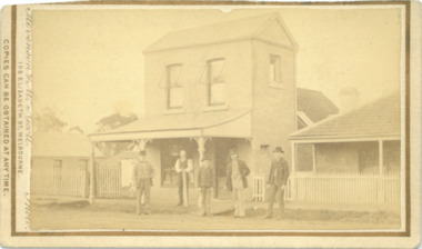
Photograph, Express Office Church Street Bacchus Marsh 1883
The Express newspaper was founded in Bacchus Marsh in 1866. From 1870 it was produced in this two-storey building in Church Street Bacchus Marsh. The first issue was published on Saturday 7th July 1866. The first issues of the Express were produced in the house of its proprietor George Lane. This house can be seen at the rear of the two-storey building in this image. Around 1889 the size of the building was doubled. The Express was initially started and operated by a syndicate of local businessmen. After only a few months the syndicate ceased and George Lane a printer and his future son-in-law Christopher Crisp took over the ownership and operation of the Express. The Crisp family were associated with the Express for over 100 years. It was both a newspaper and printing business. The Express building was in use as a newspaper and printing business until the early 1980s. Since the 1980s the building has been used for a variety of retail and commercial purposes. The original printing equipment used by the Express is still present in the building and the site has been listed as a site of state heritage significance on the Victorian Heritage Register.Small sepia unframed photograph on card with gold border framing photograph. Housed in the album, 'Photographs of Bacchus Marsh and District in 1883 by Stevenson and McNicoll'. The image depicts the Bacchus Marsh Express building in 1883. It shows a two-storey building with a pitched roof and front verandah. Five men stand in front of the building facing the camera. On the first left is George Lane one of the proprietors. Second from the left is Christopher Crisp, the co-proprietor and editor of the Express. The other three men are unidentified but are possibly employees of the Express. The house on the right belonged to George Lane. The house to the left of the building belonged to Christopher Crisp. All three buildings remain in Bacchus Marsh in 2024.On the front: Stevenson & McNicoll. Photo. 108 Elizabeth St. Melbourne. COPIES CAN BE OBTAINED AT ANY TIME. On the back: LIGHT & TRUTH inscribed on a banner surmounted by a representation of the rising sun. Copies of this Portrait can be had at any time by sending the Name and Post Office Money Order or Stamps for the amount of order to STEVENSON & McNICOLL LATE BENSON & STEVENSON, Photographers. 108 Elizabeth Street, MELBOURNE. newspapers, bacchus marsh express, christopher crisp 1844-1915, printers, george lane 1823-1899 -
 Stawell Historical Society Inc
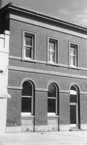
Photograph, Victoria Bank in Main Street Stawell 1991 - 2 Photos
This two story building was once The Victoria Bank, in Main Street Stawell later other businesses. Photo taken in 1991. The building now restored, and the home of Ron & Trudy Smith, who conduct a book exchange.Two black and white photographs of a two story brick building once The Victoria Bank and later a Book exchange. Doorways and windows on the ground floor have similar arch designs. The three top windows are rectangular in shape with a parapet on top of the building. One photo is a closer view of the building than the other. The photos may have been taken at different times as the window curtains appear different.stawell -
 Bendigo Military Museum
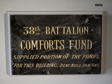
Plaque - 38TH BN COMFORTS FUND, 38th Battalion Comforts Fund, C.1921
This plaque was originally placed in the Foyer (Vestibule on original plans) of the Soldiers Memorial Institute Bendigo in 1921. After closure in 2016-18 for the renovations to SMI the plaque was then placed in what was originally called the "Writing Room" now called "The Building and RSL History Room". The plaque had the gold paint renewed about 2012 - 15.Plaque marble, grey with streaks of white through, inscription is engraved with Gold paint. The plaque is attached via 2 screws to a backing board on a wall."38th BATTALION COMFORTS FUND supplied portion of the funds for this building. Rene Neill Hon Sec"brsl, smirsl, 38th -
University of Melbourne, Burnley Campus Archives
Photograph - Black and white print, 315/15, c. 1951
Army Hut erected during building of new School. Now functions as 1. PWD Store 2. Demonstration Room 3. Temporary Fruit Preserving Kitchen & Store. EMGArmy Hut erected during building of new School. army hut, e. m. gibson collection -
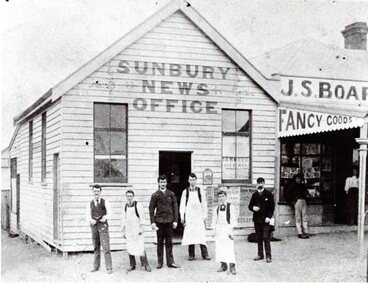 Sunbury Family History and Heritage Society Inc.
Photograph, Sunbury News Office
The Sunbury News Office was established by the Boardman family initially in Brook Street closer to the station. In 1880 Arthur Boardman opened a bookshop and news agency and in 1882, he printed the first issue of the Sunbury News.The building was on the SW corner of Brook and O'Shanassy Streets. Members of the Boardman family also ran the adjacent business. The Sunbury News was the local paper for residents until the late 1960s A non-digital black and white photograph with a cream border of a weatherboard news office building with six men standing the front. Three of the men are wearing white aprons. An attached building with a verandah is on the RHS of the office building.sunbury news, arthur boardman, brook street, o'shanassy street -
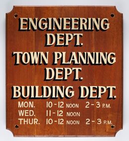 City of Greater Bendigo - Civic Collection
Sign - Municipal Departments Opening Times
History of this item is unknown but was used by one of the City, Shire or Borough Council's to advertise various department opening hours.Sign constructed from four pieces of wood. Hand painted text advertising engineering, town planning and building departments opening days and times.ENGINEERING / DEPT. / TOWN PLANNING / DEPT./ BUILDING DEPT. / MON. 10 - 12 NOON 2 - 3 PM / WED. 11 - 12 NOON / THUR. 10 - 12 NOON 2 - 3 PMcity of greater bendigo signs, city of greater bendigo administration item -
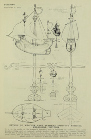 Mission to Seafarers Victoria
Drawing - Digital copy, Building Publishing, Details of weather vane, Seamens' Institute building, Melbourne, Victoria, 12 September 1923
This sketch was published in Building : the magazine for the architect, builder, property owner and merchant, Vol. 33, No. 193 (12 Sept., 1923) but Walter Butler had imagined it in the design for the mission in 1916/17. In the article published in the Herald, Thursday 30 August 1917, page 12, it is mentioned the "the architect has designed a copper ship final for the main gable of the building and it, like the gymnasium, is awaiting the collection of more funds or the generosity of a special donor."The plans confirm that Walter Butler was the designer of the vane that he had already imagined in the early sketch of the Flinders Street building in 1916 and also help us determine when was the vane made.This article was published in 1923 and the first photograph of the weathervane was only published in the 1928 Annual Report. The plans are significant as they could potentially help rebuild the weathervane stole in March 2022. Plans for the weather vane, Seamens' Institute building, Melbourne, Victoriawalter richmond butler (1864–1949), windvane, weathervane, finial, flinders street -
 Clunes Museum
Photograph
Although the inscription of .1 states this building was transported to Maryborough it's clear that the building remained in Clunes at least until the knitting mill was relocated from Fraser Street, (now known as Collins Place) to the corner of Bailey and Camp Streets, perhaps this building was extraneous its new location and was then moved to Maryborough at some date after 1918..1 SEPIA PHOTOGRAPH OF THE MOVE OF THE SALVATION ARMY HALL TO COLLINS PLACE WITH A CROWD OF PEOPLE IN FRONT OF THE BUILDING AND A LARGE "TRACTOR" IN THE DOORWAY .2 SEPIA PHOTOGRAPH OF THE MOVE OF THE SALVATION ARMY HALL TO COLLINS PLACE WITH SEVERAL PEOPLE IN FRONT OF THE BUILDING AND A TRACTOR MOVING INTO POSITION .1 on reverse; At Clunes part of mill ready for transport to Maryborough (Plate is similar not negative of this)local history, churches - salvation army, salvation army hall -
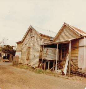 Phillip Island and District Historical Society Inc.
Photograph, 1978/79
... buildings ...January 1869 at the first land sale in Cowes, John West bought Lot 1 for £45 . In the 1870's he built the first Chicory Kiln on Phillip Island. With his brother, Solomon, he started the General Store next to the Chicory Kiln in Thompson Avenue. Over the years the original building was extended and altered.Photograph of remains of West's store, Cowes. Timber building with corrugated roofing. Old iron water tank in front of building.local history, photographs, buildings, historic, buildings - historical, sepia photograph, john cook, phillip island, west's general store