Showing 172031 items matching "streets "
-
 Eltham District Historical Society Inc
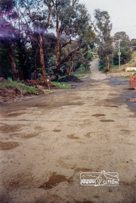
Photograph, Looking west along Brougham Street, Eltham, c.1988, 1988c
... streets ...Road construction works on Brougham Street prior to sealing, outside No. 21.Colour photographbrougham street, eltham, road construction, streets -
 Tatura Irrigation & Wartime Camps Museum
Photograph - sepia, Brooklyn Studio, Mitchell's Bush Inn, pre 1900
Very old sepia colour photograph of Mitchell's Bush Inn.Though to have been beside the flour Mill but definitely in Casey street. Photograph take from the roadway includes the house next door, several people and a horse and buggy with 2 people in. Timber in the background.Brooklyn Studio 495 Chapel Street South Yarra -
 Port Melbourne Historical & Preservation Society
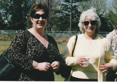
Photograph - Launch of History of a Street Precinct, 25 Sep
In 2005, members of the PMH&PS undertook a study of the residents of the houses in a Port Melbourne street precinct from the 1880s to 1960. The area is bounded by Evans Street, the E side of Bridge Street, S side of Williamstown Road, Farrell Street both the E & W sides plus the section of Ross Street between Farrell and Bridge and the part of Derham Street between Farrell and Bridge. The resulting map and an interactive CD won the Best Community Research, Registers & Records project at the 2007 Victorian Community History Awards. The project was launched on the railway reserve near the corner of Evans & Farrell streets. Liana ThOMPSON is with her mother , Fay BATES/ SHAW nee DEVINE.Liana Thompson & Fay Bates the launch of the History of a Street Precinct. 25/9/05 Liana Thompson, Fay Bates (previously Shaw nee Devine)liana thompson, fay bates, history of a street precinct -
 Bendigo Historical Society Inc.
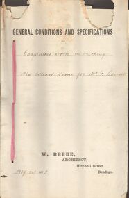
Document - MARKS COLLECTION: SPECIFICATIONS FOR CARPENTERS WORK IN ERECTING NEW BILLIARD ROOM FOR GEO LANSELL, 1st February, 1893
Contract document, held by pink secured with pink tape. On top of front page printed 'General conditions and specifications' handwritten, for Carpenters work in erecting a new billiard room for Mr. G. Lansell. On bottom of page printed : W. Beebe, Architect, Mitchell Street, Bendigo. Dated February 1, 1893.W. Beebe, Architect, Mitchel Street, Bendigobendigo, buildings, fortuna villa -
 Greensborough Historical Society
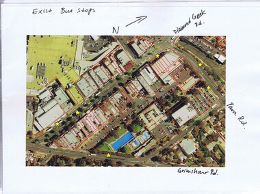
Folder, Banyule City Council, Main Street Greensborough, 2007-2011
Folder of coloured photographs of Main Street Greensborough, plus one aerial photograph of the area bounded by Grimshaw, Flintoff, Para and Main Streets and one of Grimshaw Street between Henry and Main Streets. Greensborough Shopping Centre prior to the construction of WatermarcGreen plastic folder of coloured photographic prints of Main Street Greensborough.main street greensborough, banyule city council, watermarc -
Tatura Irrigation & Wartime Camps Museum
Photograph, McNamara's saleyards
Photograph looking west along Hogan Street, of Tatura's first saleyards, run by McNamara's.Black and white photograph of 's original saleyards, Tatura. Approx 1920.on back: McNamaras Hogan Street. Original saleyards.old saleyards, tatura -
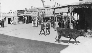 Stawell Historical Society Inc
Photograph, Main Street Stawell corner of Wimmera Street with Stabbs Coach Building visable c1920's, 1920
Sepia photo of Stawell Main Street Scene. Stabb's Coach Building on corner of Wimmera Street visible. C1920's. Possibly Easter bunting hanging in the street.Sepia Photograph of a scene in a commercial area. People in the Street. A Cow in the foreground. Stawell from the side of the P.O. (Nell Kingston)stawell -
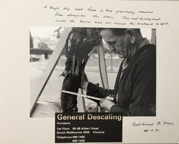 Kew Historical Society Inc
Photograph - Public Works Street Maintenance, Gellibrand Street, General Descaling, 1970
The series from which the photograph is drawn provides a snapshot by a commercial photographic studio of specific street works in Kew as well as providing examples of public works infrastructure being commissioned by local government in the 1970s. The photos originally formed part of the Engineering Department's files in the City of Kew before being donated to the Kew Historical Society.In addition to its historic importance as a record of a particular streetscape in Kew in 1970, the photograph also provides an historic record of public works by local government during the period.Public Works Street Maintenance, Gellibrand Street, Kew, Company supplied photograph of measuring a tree root in Gellibrand Street. Inscribed above photo: "A tough dry root from a tree previously removed from alongside the drain. The root development inside the barrel had not caused the brick work to split. Gellibrand St. Drain 24.4.70." Company information: "General Descaling / Company / 1st Floor 66-68 Albert Road/ South Melbourne 3205 Victoria / Telephone 699 1455 / 699 1635."general descaling, drains, gellibrand street (kew) -
 City of Kingston
Pamphlet - Colour, Fergusson & Mitchell Lith, Sandringham Rises, c. 1888
Sales plan for land in the suburb of Sandringham, bounded by Bluff Road, Bay Road and William Street, and incorporating Frances Street.The developing urban area of Highett (then called Sandringham) within the City of Kingston. This land sale pamphlet illustrates the subdivision of land within the municipality and the changing demographic of the district as new houses are constructed close to infrastructure.Colour pamphlet advertising for sale 35 lots in Sandringham Rises, Sandringham. Incorporates a map of the estate bordered by Bluff Road, Bay Road and William Street, including Frances Street.Handwritten in grey pencil next to the words 'THREE O'CLOCK': 1888 Handwritten in blue ben next to the words '& BUSINESS SITES': 1888land sales, sandringham, highett -
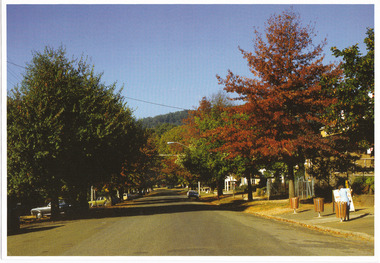 Marysville & District Historical Society
Photograph (Item) - Colour photograph, 04-1982
A colour photograph of Murchison Street in Marysville in Victoria.A colour photograph of Murchison Street in Marysville in Victoria.MARYSVILLE - APRIL 1982murchison street, marysville, victoria, photograph -
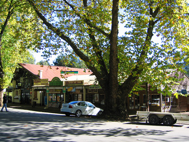 Marysville & District Historical Society
Photograph (Item) - Colour photograph, Travel Victoria, 2006
A colour photograph of Murchison Street in Marysville in Victoria.A colour photograph of Murchison Street in Marysville in Victoria. The buildings along Murchison Street were destroyed in the 2009 Black Saturday bushfires.murchison street, marysville, victoria, photograph, 2009 black saturday bushfires -
 Clunes Museum
Photograph
UNIDENTIFIED PHOTOGRAPH DONATED BY W. GAYFORD, 20 WOLSLEY STREET, MONT ALBERTBLACK AND WHITE PHOTOGRAPH STREET PARADElocal history, photography, photograph, events and celebrations -
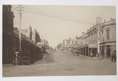 Kew Historical Society Inc
Photograph, High Street, Kew, 1891
Early photograph of High Street, Kew, looking east from Kew Junction.High Street, Kew, circa 1891.high street, kew, kew junction, streets -- kew (vic) -
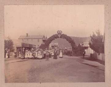
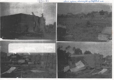 Rutherglen Historical Society
Image, c1953
Four black and white photographs, photocopied on a single piece of paper, showing damage in Murray street after mini cyclone 1952 or 1953. Written at top of page: "1952-53. Mini-cyclone. Murray Street up to Golf Club end."murray street, rutherglen golf club, weather damage, cyclone -
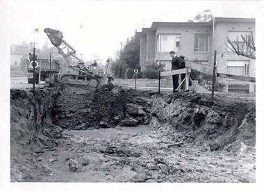 Kew Historical Society Inc
Photograph - Road works in the City of Kew, 1968-9
One of a series of photographs donated by the City Engineer of the former City of Kew, showing road works. The photos variably include council workers, signage and equipment.One of a series of photographs of core local government services as practised by the City of Kew. The photographs are an accurate record of street works of the period. Original black and white photographic positive of a road works in the former City of Kew. The photo shows an excavation in Studley Park Road near the corner of Carson Street in 1968/9. A Council officer and worker inspect the pit. Excavation equipment and a Council truck are at the back of the view. STUDLEY PARK ROAD AT CARSON STREET 1968/9city of kew, local government -- city of kew, road works, street works, kew city depot, studley park road -- kew (vic.) -
Whitehorse Historical Society Inc.
Map, Subdivision Plan for part of Blackburn Park, c1910
Photocopy of advertisement for sale of subdivision of area in BlackburnPhotocopy of advertisement for sale of subdivision of area in Blackburn between the railway line and Whitehorse Road between Station Street and Alfred Street. Some purchasers noted between 1903 - 1912.Photocopy of advertisement for sale of subdivision of area in Blackburnland subdivision, whitehorse road, blackburn, station street, blackburn, railway road, blackburn, queen street, blackburn, albert street, blackburn, chapel street, blackburn, george street, blackburn, cottage street, blackburn, alfred street, blackburn -
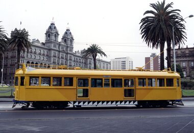 Melbourne Tram Museum
Photograph - SW5.758 on Macarthur Street, Michael McLeod, c. 1980s
Photograph shows SW5 No. 758 on Macarthur Street. Trolley poles are visible and in use. The Hotel Windsor in Spring Street is visible in the background. The tram is painted in a livery of the Transporting Art program, as a so-called "Art Tram." The artwork is by Michael Johnson, sponsored by the State Insurance Office. Photo by Michael McLeod.Shows a now-withdrawn tram with obsolete equipment (i.e., trolley poles) and livery representing a culturally important event in Melbourne's transit history.Colour Photograph - SW5.758 on Macarthur Streettrams, tramways, sw5 class, art trams, transporting art, public transport, tram 758 -
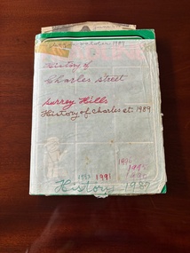 Surrey Hills Historical Society Collection
Journal - Hilary Bennet Mason's History of Charles Street, Surrey Hills
Hilary Bennet Mason (born 25/12/1911 in North Melbourne; died 16/3/2008) married Olive Marjory Muridge (B 20/7/1915; D 26/9/2001) on 30 September 1940. They has one daughter, born in 1947. Hilary had a number of occupations in his lifetime. His daughter referred to him as a tram conductor. The family lived at 7 Charles Street, Surrey Hills from c1960, having purchased it from William Stanton (Stan) Philp, a baker, and his wife Eileen. The title originally extended over 2 plots. The Philps sub-divided the land and built a new house for themselves at No 9. No 7 Charles Street had a well under the kitchen window; the house was extended in 1971/72; it was sold after Hilary Mason died in 2011. [REF: Personal communication from the donor; Alan Holt property register and online research.] The handwritten timeline refers to the area having been "called Irish Town as Catholic's were in the majority." Most of the writing is that of Hilary Mason, although some blanks have been filled in by another (unknown) hand. There is also an entry by John Whitford, who moved into a new home on the corner of Charles and Arthur Streets in 1982. The last entry is dated June 1996, when Hilary Mason would have been c 85 years old. Comment in relation to this catalogue entry: "One of the occupation that Mr Mason had was a Radio shop in Bridge Road, Richmond, called Mason's Radio. I worked for Mason's Radio in January 1963 to December 1964. Mr. Mason was a true gentleman, very kind and treated me like a son. Regards M.Zammit." (Maurice Zammit email; 9 March 2025)This is a unique piece of social history reflecting the closeness of this small suburban street.A standard lined exercise book, brand is HEADLINE, which contains a mixture of handwritten entries and pasted in and loose ephemeral items. These include house advertising flyers, newspaper clippings of a general nature and death notices, tickets, etc. The handwritten notes mostly pertain to a timeline of residents and their comings and goings to and from Charles Street in Surrey Hills, but also include some reflections on social history. Memories of other residents of the street are recorded. There are also some personal diary notes.Front cover: "begun october 1987 / History of / Charles street / Surrey Hills / History of Charles st. 1989 / 1996 / 1995 / 1993 1991 1990 / History 1987" in biro and marking pen in blue, red, brown and green. Back cover: "History / of / Surrey / Hills [1987 /1990 /1993 / 1995 / 1996] / History of / Charles street / Surrey Hills 1991" handwritten in black, blue, green, red and pink biro and marking pen.charles street, edna holzer, jack wright, john whitford, diana whitford, amanda whitford, melissa whitford, june kavanagh, aub sherlock, hilary bennet mason, olive marjory mason, noni hallier, elvis greenwood, bob peacock, ken warren, chris holford, enid holford, keith ellis, gina ellis, nita jacobsen, christine craig, peter craig, gary austin, deb austin, ian pearson, chris jacobsen, jack titansaw, peter burton, william (bill) philp, george cook, lee burton, mary pearson, bill sloan, carmel sloan, fielding's foundary, antonio panzera, annunziata panzera, nancy panzera, dr eric allan, merelyn maher, charles lyons, doug sloan, coral meehan, peter haase, steve creati -
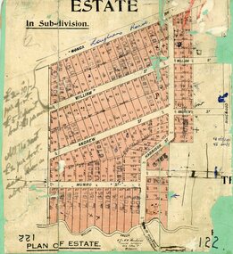 Ringwood and District Historical Society
Map, Subdivision Plan, Loughnans Road, Ringwood - circa 1922
Green card with cut-out map of residential allotments, some marked "sold". "Plan of Estate" includes Wonga Road, Loughnans Road, William Street, Andrew Street, Harrison Street, and Munro Street, Ringwood. (Surrounding area is part of Ringwood Park Estate featured in seperate 1922 auction flyer).Handwritten notations - (northern section) {£2-10/- per foot. £5 deposit bal £1 per month} All the rest £2 per foot, value same as above. Licensed Surveyors - W.J. & A.W. Kenhardt, 352 Collins Street, Melbourne. -
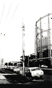 Port Melbourne Historical & Preservation Society
Photograph - Graham Street towards Albert Park, Reverend Donald LANGFORD, June 1973
Taken from the corner of Seisman Place looking towards Albert Park, the photograph was taken before the demolition of the gasometer shown on the on right. The original Albert Park High School can be seen behind the Pickles Street sign.B & W photograph of Graham Street, Port Melbourne looking towards Pickles Street.built environment - demolition, built environment - industrial, transport - roads, education - secondary schools, gasometer -
 Ballarat Heritage Services
Photograph - Photograph - Colour, Ballarat From the Regent Cinema, Lydiard Street North, Ballarat, 2015, 27/12/2016
Lydiard Street is known as an axcellent example of Victorian architecture.Various views of Ballarat's Lydiard Street Northballarat, lydiard street north, buildings, aerial, birds eye, sebastions, regent cinema -
 Marysville & District Historical Society
Photograph (Item) - Colour photograph, Unknown
A colour photograph of Murchison Street in Marysville in Victoria.A colour photograph of Murchison Street in Marysville in Victoria.murchison street, marysville, victoria, photograph -
 Marysville & District Historical Society
Photograph (Item) - Colour photograph, Unknown
A colour photograph of Murchison Street in Marysville in Victoria.A colour photograph of Murchison Street in Marysville in Victoria.murchison street, marysville, victoria, photograph -
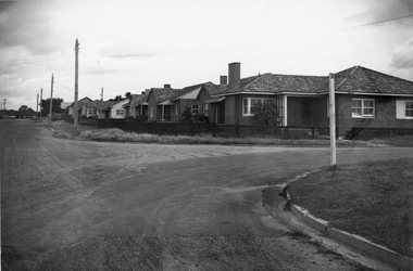 Stawell Historical Society Inc
Photograph, Housing Commission House in Dawson Street -- Photo & Newspaper Clipping
The first Housing Commission homes of brick and tiled roof built after WW2 in Stawell Dawson Street c 1950's. Also in the file a Newspaper clipping from News, Saturday, October 11. 1947. "George Mitchell Square" the first Housing Commission homes built in Stawell. George Mitchell was a member of Borough Council for 40 years and Mayor for 4 years. The housing estate was named in his honor. The architects "Buchannan Laird & Buchanan Geelong.Black and white photograph of a street scene. The photograph shows a line of brick houses along the street with timber fences. Four electric power lines are along the street with 2 in the distance. The street also has curb and guttering. The street to the right has a street post with "George Mitchell St" written on the street sign.stawell -
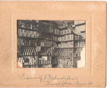 Hume City Civic Collection
Photograph
Mounted b/w photograph of the interior of J. Gilchrist and Son, general store, Evans Street, Sunbury. (Shelves of goods for sale)Handwritten on front: interior of J. Gilchrist and Sons' General Store, Evans Street Handwritten on back: H. Gilchristj. gilchrist and son, general store, business, gilchrist, h., george evans collection -
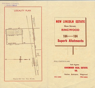 Ringwood and District Historical Society
Document - Folder, Land Sale Brochure, New Lincoln Estate, Ringwood, Vic. - circa 1960. Also 1951 newspaper advertisement
Bi-fold advertisement for sale of residential allotments - New Lincoln Estate, New Street, Ringwood, with summary of local facilities and services, locality plan, layout of sub-division, and price list. Also an advertisement from Ringwood Mail dated 12 July 1951. Subdivision includes New Street, Heywood Street, Barkly Street, Keith Grove, Maurice Avenue, Inez Avenue, Catherine Street, Neville Street, Neale Grove (later Heather Grove), and Sylvia Grove. Agent - Ringwood Real Estate Co., Station Entrance, Ringwood. (Phone) WU 6661, WU 6662.Accompanying handwritten sales notes researched in 2024 by Richard Carter - Carter Real Estate ... "Maurice Ashkanasy KC CMG owned the rectangular estate located between New, Barkly, Heywood Streets and Sylvia Grove in South-West Ringwood. It was given the name "The New Lincoln Estate". It was first advertised around July 1951 as "48 superb allotments", through Ringwood Real Estate (Station Entrance). A sub-divisional plan from CE Carter showed 152 blocks with 60-foot frontages and varying between 110 and 150 feet in length. Later, in 1954 house and land packages were offered through William White in Elsternwick - "Three modern bedrooms, large lounge-dining-room, kitchen with dinette, nicely equipped bathroom - £2,685 to £2,762, deposit £300". The roads were created and named after family members - Neale (later Heather) Grove - after Maurice's son Neal Mark Ashkanasy. The street was later re-named Heather Grove after Maurice's wife, Heather Helen Ashkanasy (Epstein), who passed away in 1999, aged 95. Neville Street - after Marice's other son, Aaron Solomon Neville Ashkanasy known as Neville. Catherine Street and Inez Street - after Heather's mother Catherine Inez Epstein. Maurice Avenue - after Maurice Ashkanasy, vendor. Keith Grove - after Keith Epstein. ..." -
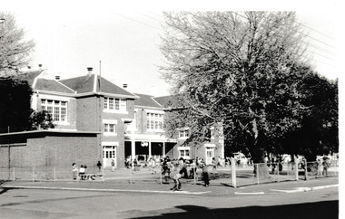 Port Melbourne Historical & Preservation Society
Photograph - Nott Street State School Port Melbourne, Reverend Donald LANGFORD, c.1970
Before closure of Stokes Street.B & W photograph of Nott Street State Schooleducation - primary schools, nott street state school -
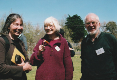 Port Melbourne Historical & Preservation Society
Photograph - Launch of History of a Street Precinct, 25 Sep
In 2005, members of the PMH&PS undertook a study of the residents of the houses in a Port Melbourne street precinct from the 1880s to 1960. The area is bounded by Evans Street, the E side of Bridge Street, S side of Williamstown Road, Farrell Street both the E & W sides plus the section of Ross Street between Farrell and Bridge and the part of Derham Street between Farrell and Bridge. The resulting map and an interactive CD won the Best Community Research, Registers & Records project at the 2007 Victorian Community History Awards. The project was launched on the railway reserve near the corner of Evans & Farrell streets. LL - R - unknown, Pat GRAINGER, Graham BRIDE.Pat GRAINGER, Graham BRIDE at the launch of the History of a Street Precinct project. 25/9/05 Not Known, Pat Grainger, Graham Bridepat grainger, graham bride, history of a street precinct -
 Kew Historical Society Inc
Plan - Subdivision Plan, J R Mathers & McMillan, Normanby Estate, c.1913
The Kew Historical Society's map collection includes a substantial number of real estate subdivision plans, mainly of Kew but also of surrounding suburbs in Melbourne. Most of the subdivision plans date from the 1920s and 1930s when the districts old homes and local farmland were being split up to accommodate residential growth in the postwar period. These early plans were assembled by a local firm, Jas R Mather & McMillan, which had an office in Cotham Road. Many of the plans, and sometimes photos, were annotated by the agents.Subdivision plans are historically important documents used as evidence for the growth of suburbs in Australia. They frequently provide information about when the land was sold as well as evidence relating to surveyors and real estate and financial agents. The numerous subdivision plans in the Kew Historical Society's collection represent working documents, ranging from the initial sketches made in planning a subdivision to printed plans on which auctioneers or agents listed the prices for which individual lots were sold. In a number of cases, the reverse of a subdivision plan in the collection includes a photograph of a house that was also for sale by the agent. These photographs provide significant heritage information relating house design and decoration, fencing and household gardens.The photograph may also be aesthetically significant depending on the importance of the photographic atelier.The Normanby Estate, which was adjacent to Normanby Road, Kew East, included thirty-one lots for sale. Streets on the subdivision plan include Adeney Avenue, Park Hill Road, Normanby Road, Weir Street and Wharton Street. Cotham Road and its tramway are shown nearby. The plan is interesting as it shows Wharton Street, named after the architect and town planner George Wharton, who was the first chairman of the Municipality of Kew. The street was to later be renamed Cecil Street. Also shown are proposed ‘Municipal Gardens’ where Parkhill Drive is now located."D" in top left corner. Stamped auctioneers contact details: "Jas. R. Mathers & Son & McMillan / Auctioneer & Land Salesmen, / 271 Collins Street / Melbourne" and Jas. R. Mathers / Estate & Financial Agent / Cotham Road / Kew".weir street - kew, wharton street - kew, normanby road - kew, cotham road - kew, municipal gardens - kew, park hill parkhill road - kew, braemar - kew, subdivision plans - kew -
Bendigo Historical Society Inc.
Photograph - BABY PORTRAIT
Sepia photograph : baby portrait. Baby sitting on something covered in a fur rug, Baby wearing a white lacy dress with a large lace collar and a plain but dark coloured bow. Portrait by Steward & Co., 284 - 286 Bourke Street, Melbourne.Stewart & Co., 284-286 Bourke Street, Melbourne. Victoriaphotograph, portrait, baby, photograph, portrait, baby, photographer stewart & co. melbourne.