Showing 1743 items matching " concrete"
-
 Melbourne Tram Museum
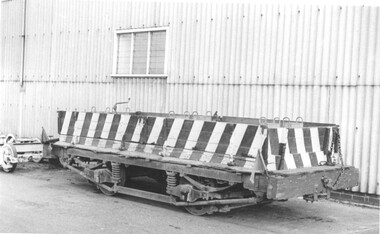
Photograph - Ballast Trailer Preston Workshops, c1960
Photograph of a ballast trailer at Preston Workshops. See page 82 of Destination City 5th Edition for details of the trailers. The wheelset or truck is a Brill 74T type. Would appear that there are some concrete weights loaded onto the vehicle. Yields information about the MMTB ballast trailers or wagons.Black and white photograph on Ilford papertramways, brill 74t, ballast wagons -
 Flagstaff Hill Maritime Museum and Village
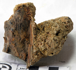
Wood sample, 1855
The artefact is a piece of ship’s timber from the wreck-site of the SCHOMBERG, a vessel which collided with the Peterborough reef on her maiden voyage in December 1855. This small wooden remnant of the disaster has been concreted on one side by the accrual of marine sediment while submerged. The build-up of sediment over the remains of the vessel is typical of the site as a whole. This artefact illustrates the reclaiming power of the ocean and the gradual disappearance of timber constructed vessels that have come to grief along this coastline (for example, the THISTLE in 1837, and the CHILDREN in 1838). The SCHOMBERG was a 2,000 ton clipper ship, specifically designed for the Australian immigration trade (back-loading wool for Britain’s mills), and constructed in Hall’s shipyard in Aberdeen, Scotland. She was owned by the Black Ball Line and launched in 1855. Alexander Hall & Son were renowned builders of sleek and fast 1,000 ton clippers for the China trade (opium in, tea out) and were keen to show they could also outclass the big North American ships built by Donald Mackay. Consequently the SCHOMBERG was ‘overbuilt’. Her hull featured five ‘skins’ of Scotch Larch and Pitch Pine overlaying each other in a diagonal pattern against a stout frame of British Oak. Oak has been favoured by builders of wooden ships for centuries. Its close, dense grain made it harder to work, but also gave it great strength and durability. In addition, the lateral spread of its branches supplied a natural curvature for the ribs of a vessel’s hull, as well as providing the small corner or curved pieces (‘knees’ and ‘elbows’) that fit them together. The shape and texture of this wood sample suggests a dense hardwood like Oak. The timber has been cut off at one end since its recovery from the sea, exposing a smooth and almost shiny surface. Seasoned English Oak has a similar light brown colour and tight grained finish. At the launch the SCHOMBERG’s 34 year old master, Captain ‘Bully’ Forbes, had promised Melbourne in 60 days, "with or without the help of God." James Nicol Forbes was born in Aberdeen in 1821 and rose to fame with his record-breaking voyages on the famous Black Ball Line ships; MARCO POLO and LIGHTNING. In 1852 in the MARCO POLO he made the record passage from London to Melbourne in 68 days. There were 53 deaths on the voyage but the great news was of the record passage by the master. In 1954 Captain Forbes took the clipper LIGHTNING to Melbourne in 76 days and back in 63 days, this was never beaten by a sailing ship. He often drove his crew and ship to breaking point to beat his own records. He cared little for the comfort of the passengers. On this, the SCHOMBERG’s maiden voyage, he was going to break records. SCHOMBERG departed Liverpool on her maiden voyage on 6 October 1855 flying the sign “Sixty Days to Melbourne”. She departed with 430 passengers and 3000 tons cargo including iron rails and equipment intended to build the Melbourne to Geelong Railway and a bridge over the Yarra from Melbourne to Hawthorn. She also carried a cow for fresh milk, pens for fowls and pigs, 90,000 gallons of water for washing and drinking. It also carried 17,000 letters and 31,800 newspapers. The ship and cargo was insured for $300,000, a fortune for the time. The winds were poor as she sailed across the equator, slowing SCHOMBERG’s journey considerably. Land was first sighted on Christmas Day, at Cape Bridgewater near Portland, and Captain Forbes followed the coastline towards Melbourne. Forbes was said to be playing cards when called by the Third Mate Henry Keen, who reported land about 3 miles off, Due in large part to the captain's regarding a card game as more important than his ship, it eventually ran aground on a sand spit near Curdie's Inlet (about 56 km west of Cape Otway) on 26 December 1855, 78 days after leaving Liverpool. The sand spit and the currents were not marked on Forbes’s map. Overnight, the crew launched a lifeboat to find a safe place to land the ship’s passengers. The scouting party returned to SCHOMBERG and advised Forbes that it was best to wait until morning because the rough seas could easily overturn the small lifeboats. The ship’s Chief Officer spotted SS QUEEN at dawn and signalled the steamer. The master of the SS QUEEN approached the stranded vessel and all of SCHOMBERG’s passengers and crew were able to disembark safely. The SCHOMBERG was lost and with her, Forbes’ reputation. The Black Ball Line’s Melbourne agent sent a steamer to retrieve the passengers’ baggage from the SCHOMBERG. Other steamers helped unload her cargo until the weather changed and prevented the salvage teams from accessing the ship. Later one plunderer found a case of Wellington boots, but alas, all were for the left foot! Local merchants Manifold & Bostock bought the wreck and cargo, but did not attempt to salvage the cargo still on board the ship. They eventually sold it on to a Melbourne businessman and two seafarers. In 1864 after two of the men drowned when they tried to reach SCHOMBERG, salvage efforts were abandoned. Parts of the SCHOMBERG were washed ashore on the south island of New Zealand in 1870, nearly 15 years after the wreck. The wreck now lies in almost 9 metres of water. Although the woodwork is mostly disintegrated the shape of the ship can still be seen due to the remaining railway irons, girders and the ship’s frame. A variety of goods and materials can be seen scattered about nearby. Flagstaff Hill holds many items salvaged from the SCHOMBERG including a ciborium (in which a diamond ring was concealed), communion set, ship fittings and equipment, personal effects, a lithograph, tickets and photograph from the SCHOMBERG. One of the SCHOMBERG bells is in the Warrnambool Library. The SCHOMBERG collection as a whole is of historical and archaeological significance at a State level, listed on the Victorian Heritage Register VHR S612. Flagstaff Hill’s collection of artefacts from the SCHOMBERG is significant for its association with the Victorian Heritage Registered shipwreck. The collection is primarily significant because of the relationship between the objects, as together they have a high potential to interpret the story of the SCHOMBERG. The SCHOMBERG collection is archaeologically significant as the remains of an international passenger ship. The shipwreck collection is historically significant for representing aspects of Victoria’s shipping history and its potential to interpret sub-theme 1.5 of Victoria’s Framework of Historical Themes (living with natural processes). The collection is also historically significant for its association with the shipwreck and the ship, which was designed to be fastest and most luxurious of its day. The SCHOMBERG collection meets the following criteria for assessment: Criterion A: Importance to the course, or pattern, of Victoria’s cultural history. Criterion B: Possession of uncommon, rare or endangered aspects of Victoria’s cultural history. Criterion C: Potential to yield information that will contribute to an understanding of Victoria’s cultural history. A piece of wood, concreted in sediment, from the wreck of the SCHOMBERG (1855). The limestone accretion includes sand, shell grit and marine worm casings. The exposed surface of the wood is broken and worn smooth along the grain. One end of the timber has been cut or sawn off across the grain, presenting a smooth and shiny surface.flagstaff hill, warrnambool, shipwrecked-coast, flagstaff-hill, flagstaff-hill-maritime-museum, maritime-museum, shipwreck-coast, flagstaff-hill-maritime-village, wood segment, schomberg, shipwreck timber, alexander hall and son, limestone concretion, oak-framed hull -
 Lara RSL Sub Branch
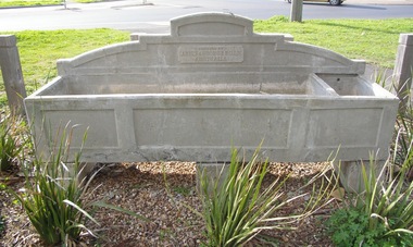
bills trough
The Bills Cement Trough consists of two parts a large horse trough and a smaller dog,trough which was donated by Annis and George Bills. It is not known whether this trough was donated and installed prior to or after the death of George Bills in 1927. The installation was under taken by The Metropolitan Drinking and Cattle Trough Association which had been set up in England by an English Organisations in 1859 to provide water facilities for both drivers and animals. The Bills drinking trough, corner of Walker and Rennie Streets, Lara, is significant as it forms part of the Annis and George Bills Estate., which was established to provide watering facilities for horses after George's death in 1927. The concrete structure is also a legacy of the days of horse drawn vehicles before cars were introduced.The Billa concrete trough is associated with Annis and George from 1927 who establish a fund in the early 20th century to provide adequate watering facilities for horses and dogs. It is just one of over more than one troughs throughout Australia and the United States. -
 Phillip Island and District Historical Society Inc.
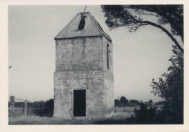
Photograph, 1960's
Donated by N. M. & J. D. Archibald. April, 1973.Black & White Photograph. Chicory Kiln, Newhaven - Main Road. Remains of brick & concrete Kiln, with very old pear tree nearby. Built by Mr. Bern Denham as a young man in the 1920s (J. Box, personal communication). Chicory Kiln Album.local history, photography, photographs, agriculture buildings, historic, chicory kiln, newhaven, phillip island, n & j archibald, b denham -
 Flagstaff Hill Maritime Museum and Village
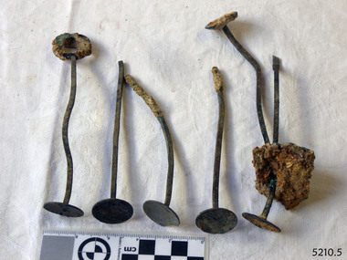
Domestic object - Drink Stirrers, Before 1878
History of the Loch Ard: The Loch Ard got it’s name from ”Loch Ard” a loch which lies to the west of Aberfoyle, and to the east of Loch Lomond. It means "high lake" in Scottish Gaelic.The vessel belonged to the famous Loch Line which sailed many vessels from England to Australia. The Loch Ard was built in Glasgow by Barclay, Curdle and Co. in 1873, the vessel was a three-masted square-rigged iron sailing ship that measured 79.87 meters in length, 11.58 m in width, and 7 m in depth with a gross tonnage of 1693 tons with a mainmast that measured a massive 45.7 m in height. Loch Ard made three trips to Australia and one trip to Calcutta before its fateful voyage. Loch Ard left England on March 2, 1878, under the command of 29-year-old Captain Gibbs, who was newly married. The ship was bound for Melbourne with a crew of 37, plus 17 passengers. The general cargo reflected the affluence of Melbourne at the time. Onboard were straw hats, umbrella, perfumes, clay pipes, pianos, clocks, confectionery, linen and candles, as well as a heavier load of railway irons, cement, lead and copper. There were other items included that were intended for display in the Melbourne International Exhibition of 1880. The voyage to Port Phillip was long but uneventful. Then at 3 am on June 1, 1878, Captain Gibbs was expecting to see land. But the Loch Ard was running into a fog which greatly reduced visibility. Captain Gibbs was becoming anxious as there was no sign of land or the Cape Otway lighthouse. At 4 am the fog lifted and a lookout aloft announced that he could see breakers. The sheer cliffs of Victoria's west coast came into view, and Captain Gibbs realised that the ship was much closer to them than expected. He ordered as much sail to be set as time would permit and then attempted to steer the vessel out to sea. On coming head-on into the wind, the ship lost momentum, the sails fell limp and Loch Ard's bow swung back towards land. Gibbs then ordered the anchors to be released in an attempt to hold its position. The anchors sank some 50 fathoms - but did not hold. By this time the ship was among the breakers and the tall cliffs of Mutton Bird Island rose behind. Just half a mile from the coast, the ship's bow was suddenly pulled around by the anchor. The captain tried to tack out to sea, but the ship struck a reef at the base of Mutton Bird Island, near Port Campbell. Waves subsequently broke over the ship and the top deck became loosened from the hull. The masts and rigging came crashing down knocking passengers and crew overboard. When a lifeboat was finally launched, it crashed into the side of Loch Ard and capsized. Tom Pearce, who had launched the boat, managed to cling to its overturned hull and shelter beneath it. He drifted out to sea and then on the flood tide came into what is now known as Loch Ard Gorge. He swam to shore, bruised and dazed, and found a cave in which to shelter. Some of the crew stayed below deck to shelter from the falling rigging but drowned when the ship slipped off the reef into deeper water. Eva Carmichael a passenger had raced onto the deck to find out what was happening only to be confronted by towering cliffs looming above the stricken ship. In all the chaos, Captain Gibbs grabbed Eva and said, "If you are saved Eva, let my dear wife know that I died like a sailor". That was the last Eva Carmichael saw of the captain. She was swept off the ship by a huge wave. Eva saw Tom Pearce on a small rocky beach and yelled to attract his attention. He dived in and swam to the exhausted woman and dragged her to shore. He took her to the cave and broke the open case of brandy which had washed up on the beach. He opened a bottle to revive the unconscious woman. A few hours later Tom scaled a cliff in search of help. He followed hoof prints and came by chance upon two men from nearby Glenample Station three and a half miles away. In a complete state of exhaustion, he told the men of the tragedy. Tom then returned to the gorge while the two men rode back to the station to get help. By the time they reached Loch Ard Gorge, it was cold and dark. The two shipwreck survivors were taken to Glenample Station to recover. Eva stayed at the station for six weeks before returning to Ireland by steamship. In Melbourne, Tom Pearce received a hero's welcome. He was presented with the first gold medal of the Royal Humane Society of Victoria and a £1000 cheque from the Victorian Government. Concerts were performed to honour the young man's bravery and to raise money for those who lost family in the disaster. Of the 54 crew members and passengers on board, only two survived: the apprentice, Tom Pearce and the young woman passenger, Eva Carmichael, who lost her family in the tragedy. Ten days after the Loch Ard tragedy, salvage rights to the wreck were sold at auction for £2,120. Cargo valued at £3,000 was salvaged and placed on the beach, but most washed back into the sea when another storm developed. The wreck of Loch Ard still lies at the base of Mutton Bird Island. Much of the cargo has now been salvaged and some items were washed up into Loch Ard Gorge. Cargo and artefacts have also been illegally salvaged over many years before protective legislation was introduced in March 1982. One of the most unlikely pieces of cargo to have survived the shipwreck was a Minton majolica peacock- one of only nine in the world. The peacock was destined for the Melbourne 1880 International Exhibition in. It had been well packed, which gave it adequate protection during the violent storm. Today the Minton peacock can be seen at the Flagstaff Hill Maritime Museum in Warrnambool. From Australia's most dramatic shipwreck it has now become Australia's most valuable shipwreck artifact and is one of very few 'objects' on the Victorian State Heritage Register.The shipwreck of the Loch Ard is of significance for Victoria and is registered on the Victorian Heritage Register ( S 417). Flagstaff Hill has a varied collection of artefacts from Loch Ard and its collection is significant for being one of the largest accumulation of artefacts from this notable Victorian shipwreck. The collections object is to also give us a snapshot into history so we are able to interpret the story of this tragic event. The collection is also archaeologically significant as it represents aspects of Victoria's shipping history that allows us to interpret Victoria's social and historical themes of the time. The collections historically significance is that it is associated unfortunately with the worst and best-known shipwreck in Victoria's history. Brass drink stirrers or swizzle sticks, set of six. One is complete with a narrow shank, loop handle on top, and disc on base. Others have the handle missing, and a block of concretion joins two. Surfaces have encrustatio. Recovered from the Loch Ard.flagstaff hill, warrnambool, shipwrecked coast, flagstaff hill maritime museum, maritime museum, shipwreck coast, flagstaff hill maritime village, great ocean road, loch line, loch ard, captain gibbs, eva carmichael, tom pearce, glenample station, mutton bird island, loch ard gorge, brass drink stirrers, swizzle-sticks, beverage accessory -
 Glenelg Shire Council Cultural Collection
Photograph - Photograph - Main Breakwater construction, Portland, n.d
Port of Portland Authority Archivesport of portland archives, main breakwater, construction, portland harbour, harbour development -
 Anglesea and District Historical Society
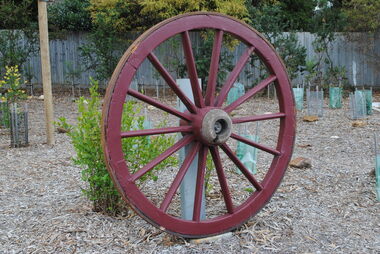
Wagon Wheel
Wooden wagon wheel from a farm wagon used in the early 1900's. The wheel is wooden with wooden spokes and an iron tyre. Restored at Anglesea Mens Shed and painted by Ryan McKnight. Jim Tutt secured it on a concrete pad with a galvanised post for display.wagon, wheel -
 City of Ballarat
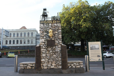
Artwork, other - Public Artwork, The Pioneer Miner's Monument, 1951
The Pioneer Miners’ Monument marks the very first finding of gold at Poverty Point in 1851. The quartz structure features a replica of the 62.8kg Welcome Nugget – the world’s largest at the time, found in Ballarat in 1858. The original was once displayed, and local mothers would sit their babies on top for luck. The artwork tells the story of gold discovery with plaques and dates of some of the more famous gold nuggets finds in Ballarat and is a reminder that these gold discoveries changed the world for Australians. The monument is of aesthetic and historical significance to the people of BallaratFitted copper miniature poppet head set atop a rough made plinth in Quartz and concrete mortar. A copy of the Welcome Nugget (Ballarat) is affixed to the front of the memorial. Includes several plaques listing the nuggets, the companies involved, the shop that paid for the last repair. THIS MONUMENT WAS ERECTED/ BY THE BALLARAT HISTORICAL/ SOCIETY TO COMMEMORATE THE/ FINDING OF GOLD AT POVERTY/ POINT 21ST AUGUST 1851 AND IS/ DEDECATED TO THE MEMORY OF/ PIONEER MINERS OF BALLARATgold, ballaraat, gold rush -
 Hume City Civic Collection
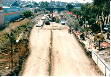
Photograph, 21/04/2005
This photograph was taken during the upgrade of the Bendigo Railway line at the Sunbury Station in 2005. The upgrade took twelve months to complete and during this time bus services replaced the trains for commuters along Bendigo line.A coloured photograph of the construction on the site of the Sunbury Railway Station. The old railway lines have been removed and the bluestone road over rail bridge can be seen with excavation equipment in front of it. Concrete sleepers which replaced the old sleepers are on the LHS of the photograph.railways, bendigo line, railway stations, bridges, bluestone bridges, sunbury railway station, george evans collection -
 Stawell Historical Society Inc
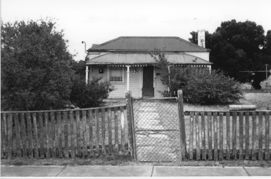
Photograph, Richardson Residence
Family home at 13 Bennett St Stawell of Mabel Annie Richardson. Weatherboard Home with front verandah, four posts two windows and front door with no 13 near it. Concrete path with wire gate and timber fence at front. Various shrubs, clothesline. -
 Lakes Entrance Historical Society
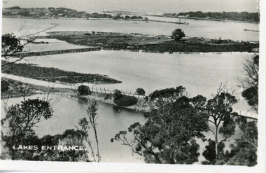
Postcard - Bullock Island, 1920c
1 x Faded miniature postcard 6.5 x 8.5|1 x Black and white 9.5 x 12 copied from album in private hands|1 x Sepia toned 10 x 15|1 x Black and white 12 x 17.5Black and white small format postcard of Bullock Island. It shows the approaches to the concrete North Arm Bridge over North Arm, the footbridge to Bullock Island, the entrance to the Gippsland Lakes from Bass Strait and part of the township on the hummocks. Lakes Entrance VictoriaLakes Entrancewaterways, topography, islands, bridges -
 Lakes Entrance Historical Society
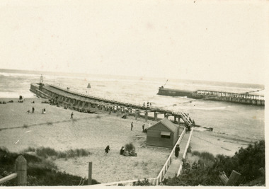
Photograph - The Entrance
Black and white photograph showing piers and entrance from ocean - Bass Strait. Concrete extensions completed, kiosk next to boardwalk. Appears to be cold day, few people about, wearing coats and sheltering behind tussocks, kiosk window half open.boardwalk, restaurant, waterways, beaches -
 Lakes Entrance Historical Society
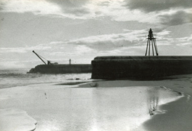
Photograph - Entrance Piers, 1917c
Black and white photograph showing concrete extensions to original piers at entrance to Gippsland Lakes from ocean Bass Strait. Eastern pier in foreground finished, western pier in background not finished, crane still in use. Beach in foreground. Lakes Entrance Victoriapiers, waterways -
 Lakes Entrance Historical Society
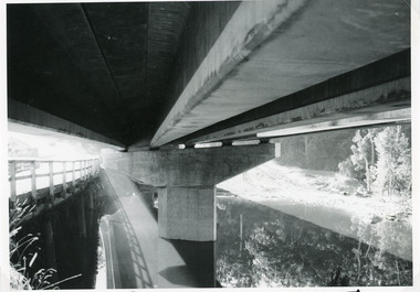
Photograph - Bridges, Lakes Post Newspaper, 1991
This photo appeared in the Lakes Post Newpaper 24 July 1991Black and white photograph looking under the decking of the new Princes Highway concrete bridge over Toorloo Arm, showing the support pier shaped to fit the camber of the curved bridge. Timber bridge in left of image still in use. Toorloo Arm Victoriabridges, construction -
 Glen Eira Historical Society
Photograph, Beauville Avenue, 3, Murrumbeena, 2001
Originally labelled "Beauville Estate, Established 1936, Still Thriving 65 years on, 10th March 2001", the Beauville Estate Album contains colour photographs of houses in the Estate. They were taken around the time of the Beauville Estate’s 65th Heritage Celebration held on 10/03/2001 and donated to the Caulfield Historical Society shortly afterwards. Photographer Bev Baxter. City of Glen Eira’s Heritage Management Plan Vol 2 p79 (this is p84 of the pdf version) – HO12 Beauville Estate and environs, Murrumbeena: The Beauville Historic Area is important at the State level as the first large housing estate undertaken by the AV Jennings Construction Co, later Jennings Group Limited, Victoria’s largest home builder. It is important also as a very early estate development incorporating a range of features other than houses and including made roads, shops and recreation facilities. In this respect it was the forerunner of the comprehensively planned housing estate of the post war era. The estate is distinguished by its aesthetic values, as is the earlier and comparable Hillcrest Estate, which are formed by a combination of restrained diversity in house styles, with the exception of no. 30 in the emerging International style, and by a landscaped garden environment. Colour photograph of cream coloured rendered house with unpainted brick features. Other features include a semi circular porch, tiled roof, chimney and a low unpainted brick fence in the foreground with small shrubs behind. A concrete path crosses the lawn to the porch.murrumbeena, houses, beauville avenue, architectural styles, 1930's, inter war style, a.v. jennings, av jennings, jennings, brick houses, beauville estate, sir albert victor jennings, a v jennings construction co, beauville estate heritage area, glen eira city council, architectural features, jennings group limited, land subdivision, gardens, beauville historic area, porches, chimneys, brick fences -
 Bendigo Historical Society Inc.
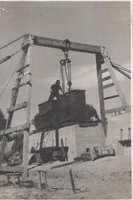
Photograph - Napoleon Reef Gold Mine Battery Site, 1936
The Napoleon (BML) gold mine (1932) was located beside McDougall Road, Golden Gully, between Martin and Hattam Street. It had a depth of 921 feet. It was one of the latest and most lavish of Bendigo's mines. Plant and equipment were electrically driven. The four-compartment shaft, extra large by goldfield's standards, measured 17 feet 6 inches by 5 feet 2 inches and was cement lined below 900 feet instead of being red gum boxed as was the usual practice. The workshop was equipped to carry out all repairs for the equally lavish BML mines on the Nell Gwynne and Carshalton reefs. (The Gold Mines of Bendigo, Book 2, Arthur Victor Palmer)Significant to mining history of Bendigo.Black and white photograph of a stamper head being lowered into position on the battery site of the Napoleon Reef Gold Mine. A wooden gantry supports the battery head as it being lowered, a man is standing on top of the stamper head. Concrete foundations are visible in immediate background. napoleon gold mine, napoleon reef gold mine -
 Eltham District Historical Society Inc
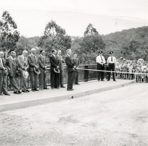
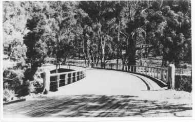
Photograph, Opening Warrandyte Bride, 8 Dec 1955
Built at a cost of £75,000 the five-span reinforced concrete bridge replaced the oldest bridge across the Yarra river, linking the Shire of Doncaster-Templestowe on the south bank with Eltham on the north. The bridge was opened by Mr. G. Reid, M.L.A.Three black and white photographsbridges, warrandyte, yarra river, councillors, ceremonies, stanley addison -
Tatura Irrigation & Wartime Camps Museum
Photograph, D. Walker, Horse trough Tatura, 1986
Photograph of concrete horse trough in Walshe Street Tatura. Built in memory of Annis and George Bills, who had no family and donated money to build horse troughs in many towns. Flowers are planted in trough by Parks and Garden workers.Black and white photograph of horse trough, Tatura.on back: horse trough, donated by Annis and George Bills, Tatura, 1986annis and george bills -
 Hume City Civic Collection
Photograph, late 1970s
The photograph was taken before the wooden Holden Bridge which spans an arm of the Deep Creek at Bulla was replaced by a more sunstantial concrete structure. As well as building a new bridge, the sharp bend and approach to the old bridge was also removed.A black and white photograph of a wooden road bridge with eucalypt trees growing on either side of the bridge.bridges, holden bridge, shire of bulla, george evans collection -
 Ballarat Heritage Services
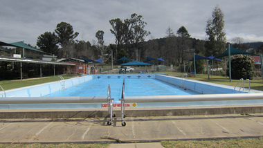
Photograph - digital photographs, Lisa Gervasoni, Marysville Pre Olympic Swimming Pool, c2010-2017
The Marysville Swimming Pool was one of the few structure to survive the 'Black Saturday' bushfire.Colour photograph of the Marysville Pre-Olympic Swimming Pool. swimming pool, sport, swimming, pre olympic, concrete, marysville, black saturday, bushfire -
 Ballarat Heritage Services
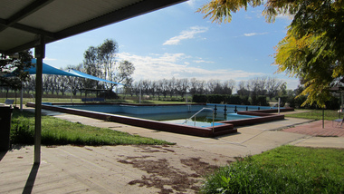
Photograph - digital photographs, Lisa Gervasoni, Leichville Memorial pre olympic swimming pool, c2010-2017
Colour photograph of an emptyl pre olympic swimming poolswimming pool, sport, swimming, pre olympic, concrete, memorial, leichville, leichville memorial swimming pool -
 Harcourt Valley Heritage & Tourist Centre
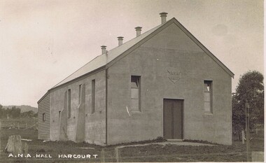
postcard, A N A Hall, Harcourt, 1915
Harcourt branch of the Australian Natives Association was formed in 1908, meeting in a chaff shed behind the local grocer shop. In 1911 the branch contracted with Mr Sutherland of Barkers Creek to build a hall of boxed concrete construction. Sutherland was a pioneer in the use of concrete for structural purposes.He subsequently had a career as City Engineer at Camberwell. The ANA branch conducted many social occasions in the hall and gave community leadership for upwards of fifty years in addition to its friendly society/health insurance activities.. This was the only community hall in the Harcourt community until it was superseded by the Harcourt Leisure Centre in 1991 It is now the home of Harcourt Heritage Centre.A community hall of pioneering construction method, provided to the community by a friendly society.black and white postcard depicting a community hallA N A Hall, Harcourt -
 Halls Gap & Grampians Historical Society
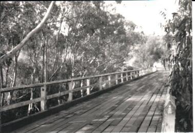
Photograph - Photocopy, C 1930s
The third Delley's Bridge, a timber and concrete structure with a curved deck, built in 1940. It was situated slightly upstream from the previous bridge. After nearly 50 years of its use, wear and tear necessitated a fourth bridge to be erected in 2001.The picture shows a curving bridge with a wood and wire railing. An unsurfaced road crosses the bridge and the area is surrounded by trees.structures, tents -
 Eltham District Historical Society Inc
Photograph, Main Road Bridge, Eltham, c.1924
The wooden Main Road Bridge was substantially damaged in the 1924 flood and was replaced with a concrete structure Pages from a scrapbook belonging to Heather Jenkins (nee Sargeant) who lived as a child in the Police Residence at 728 Main Road, Eltham in the 1920s.This photo shows the flood damage to the bridge structure or the dismantling of the bridge post 1924 flood. Heather Sargeant was the daughter of Constable W.C. Sargeant, the local police officer in residence at Eltham, 1922-1927Glued on a brown paper scrapbook page (torn from scrapbook) with 9 black and white/sepia photos of varying sizes, 1 newspaper clipping and handwritten captions in ink.On verso in pencil "Const. W.C. Sargeant 1922-1927 - see Police list"heather jenkins (nee sargeant), eltham, police residence, constable w.c. sargeant, main road, main road bridge -
 Eltham District Historical Society Inc
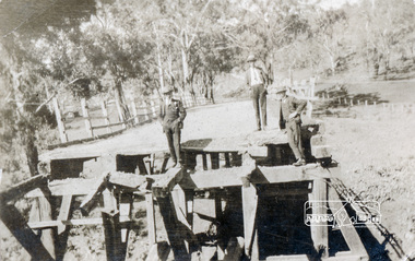
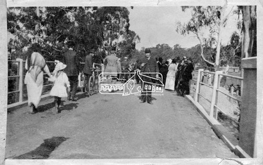
Photograph, Hurstbridge - Cr. Price crossing New Bridge (Opening Day), 1917, 1917
Eltham Shire Councillor Albert Price joined over 500 spectators for the official opening of the new re-inforced concrete bridge across the Diamond Creek at Hurstbridge. Eltham Shire shared the cost of the construction of the bridge with Heidelberg and Whittlesea Shires.This photo forms part of a collection of photographs gathered by the Shire of Eltham for their centenary project book, "Pioneers and Painters: 100 years of the Shire of Eltham" by Alan Marshall (1971). The collection of over 500 images is held in partnership between Eltham District Historical Society and Yarra Plenty Regional Library (Eltham Library) and is now formally known as 'The Shire of Eltham Pioneers Photograph Collection.' It is significant in being the first community sourced collection representing the places and people of the Shire's first one hundred years.Digital imagesepp, shire of eltham pioneers photograph collection, diamond creek, hurstbridge, wattle glen, bridge, councilor price, opening day, diamond creek (river) -
 Bendigo Military Museum
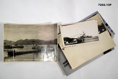
Photograph - PHOTOGRAPHS, BCOF, JAPAN, C.1946 - 47
Items in the collection re Clarence Shearing, refer Cat No 7089.16P for his service details.Photographs B & W and colour various sizes some are reprints of originals. Two are ships in harbour. One re troops unloading from a landing craft. One of twin very large Japanese gun in a concrete emplacement. Nine aircraft various mostly fighters.On rear of one, "Inland sea Japan"photographs, bcof, japan -
 Glen Eira Historical Society
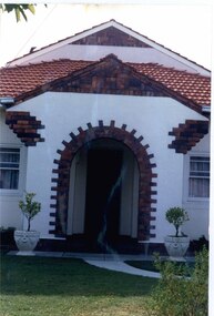
Photograph, Beauville Avenue, 27, Murrumbeena, 2001
Originally labelled "Beauville Estate, Established 1936, Still Thriving 65 years on, 10th March 2001", the Beauville Estate Album contains colour photographs of houses in the Estate. They were taken around the time of the Beauville Estate’s 65th Heritage Celebration held on 10/03/2001 and donated to the Caulfield Historical Society shortly afterwards. Photographer unknown.City of Glen Eira’s Heritage Management Plan Vol 2 p79 (this is p84 of the pdf version) – HO12 Beauville Estate and environs, Murrumbeena: The Beauville Historic Area is important at the State level as the first large housing estate undertaken by the AV Jennings Construction Co, later Jennings Group Limited, Victoria’s largest home builder. It is important also as a very early estate development incorporating a range of features other than houses and including made roads, shops and recreation facilities. In this respect it was the forerunner of the comprehensively planned housing estate of the post war era. The estate is distinguished by its aesthetic values, as is the earlier and comparable Hillcrest Estate, which are formed by a combination of restrained diversity in house styles, with the exception of no. 30 in the emerging International style, and by a landscaped garden environment. Colour photograph of the porch and surrounds for a white rendered house with unpainted variegated brown brick features and a later second storey addition. The porch has a wide decorative arched entrance, garden urns in front of the porch and a curved concrete path through the lawn to the porch. murrumbeena, houses, beauville avenue, architectural styles, 1930's, inter war style, a.v. jennings, av jennings, jennings, brick houses, beauville estate, porches, arches, sir albert victor jennings, a v jennings construction co, beauville estate heritage area, glen eira city council, architectural features, jennings group limited, land subdivision, gardens, beauville historic area, brick features, outdoor ornaments, rendered houses, gables -
 Glen Eira Historical Society
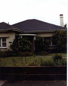
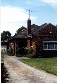
Photograph, Dalny Road, 15, Murrumbeena, 2001
Originally labelled "Beauville Estate, Established 1936, Still Thriving 65 years on, 10th March 2001", the Beauville Estate Album contains colour photographs of houses in the Estate. They were taken around the time of the Beauville Estate’s 65th Heritage Celebration held on 10/03/2001 and donated to the Caulfield Historical Society shortly afterwards. Photographer unknown. City of Glen Eira’s Heritage Management Plan Vol 2 p79 (this is p84 of the pdf version) – HO12 Beauville Estate and environs, Murrumbeena: The Beauville Historic Area is important at the State level as the first large housing estate undertaken by the AV Jennings Construction Co, later Jennings Group Limited, Victoria’s largest home builder. It is important also as a very early estate development incorporating a range of features other than houses and including made roads, shops and recreation facilities. In this respect it was the forerunner of the comprehensively planned housing estate of the post war era. The estate is distinguished by its aesthetic values, as is the earlier and comparable Hillcrest Estate, which are formed by a combination of restrained diversity in house styles, with the exception of no. 30 in the emerging International style, and by a landscaped garden environment. Colour photograph of an unpainted variegated brown brick house and garage with decorative brickwork. Other features include tiled roof, porch, tall feature chimney with a TV aerial attached, white-framed sash windows, awnings, white garage door and a concrete driveway.15murrumbeena, houses, architectural styles, 1930's, inter war style, a.v. jennings, av jennings, jennings, brick houses, beauville estate, dalny road, sir albert victor jennings, a v jennings construction co, beauville estate heritage area, glen eira city council, architectural features, jennings group limited, land subdivision, gardens, beauville historic area, brick features, garages (private), porches, arches, chimneys, sash windows, drives, awnings -
Glenelg Shire Council Cultural Collection
Photograph - Photograph - Portland Harbour, n.d
Port of Portland Authority Archivesport of portland archives, harbour, portland, ocean pier, construction, crane -
 Bendigo Historical Society Inc.
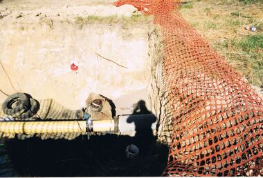
Photograph - CASTLEMAINE GAS COMPANY COLLECTION: PHOTO EXCAVATION
Yellow pipe connected to old concrete pipe. Main trench welding new to old, shadow of photographer, two tyres near pipe on left side, white flexible ring in centre foreground, orange safety netting lying along right side of the trench.Kodakorganisation, industry, gas and fuel