Showing 2592 items
matching parts of buildings or structures
-
 Kew Historical Society Inc
Map, MMBW, MMBW Plan No.68 Kew, 1900-1910
The Melbourne and Metropolitan Board of Works (MMBW) was established by an act of the Victorian Parliament in 1890 to prepare for and to implement a sewerage and water reticulation system across what was then inner Melbourne, its surrounding and middle distance suburbs, including Kew. The MMBW was disbanded in 1991.The map collection of the Kew Historical Society has at its core the historic maps assembled and originally stored in the City Engineer's Department of the City of Kew. These include maps in a number of scales. The vast majority of maps were produced by the MMBW in the first two decades of the twentieth century, and are solid working maps, backed by linen for durability. These maps are historically significant to Kew, the City of Boroondara and to the history of the development of state utilities in Victoria. A number of the Kew maps have additional details added by former municipal officers, including the levels reached by various floods. As these were working documents, information was added to them long after the period of their initial production and distribution.Early map of part of the Borough of Kew, created in the first decade of the twentieth century, at a scale 160 ft to 1 inch. The map covers what was then the north central part of Kew, bordered in the north by Oak Avenue, in the west by the Yarra River and Connor's Creek, in the south by Beresford and Carnegie Avenues, and in the east by Glass's Creek and Burke Road. The map shows the extent of urban development by that time, prominent institutions and the outlines of built structures in the municipality. Contour lines and the levels of historic floods were added in ink to the map at a later stage.MELBOURNE AND METROPOLITAN BOARD OF WORKS / PLAN NO. 68 / KEW melbourne & metropolitan board of works, mmbw maps, mmbw plans, borough of kew, cartography -
 Beechworth Cemetery Trust
Functional object - Beechworth Cemetery Rotunda, Rotunda
Wooden octagonal outdoor structure with red iron and oregon pine roof, cream painted iron lace work, 8 green metal pillars, red wooden finial, light green wooden storage room, light green wooden seat all around the storage room. Window without glass opposite door. Tap attached to a pillar right hand side of door. Metal rubbish bin near outdoor seating between 2 back pillars. Asphalt flooring and stone curbing.Cemetery map in glass cabinet on storage wall left hand side of door. There are 4 small stainless steel plaques on right hand wall near window - Margaret Carlton, John Holt, Bob Simpson and Rob Goodwin. -
Clunes Museum
Document - ARCHITECTURAL DRAWINGS, CLUNES WATER SUPPLY
CLUNES WATER SUPPLY .1 DRAWING No 21 (CHANGED TO 11). LOWER WEIR. DETAILS OF MASONRY - DESIGN B .2 DRAWING No 5 CONTRACT No 2. LONGITUDINAL SECTION OF CENTRE LINE OF LOWER AQUEDUCT FROM WEIR A TO SERVICE RESERVOIR .3 DESIGNS FOR WEIRS - CROSS SECTION OF THE BED OF THE CREEK SHOWING WEIR STRUCTURE. .4 DRAWING No 11. LONGITUDINAL SECTION - PROPOSED LINE OF PIPES No 1 RESERVOIR. .5 DRAWING No 17 SECTIONS. HANDWRITTEN. .6 DRAWING No 5. PLAN OF LINE OF PIPES No 1 RESERVOIR..2 HANDWRITTEN NOTES ON REAR IN PENCILclunes, water supply, drawings -
 Melbourne Tram Museum
Photograph - Set of 5 Black & White Photograph/s, Melbourne & Metropolitan Tramways Board (MMTB), 1966
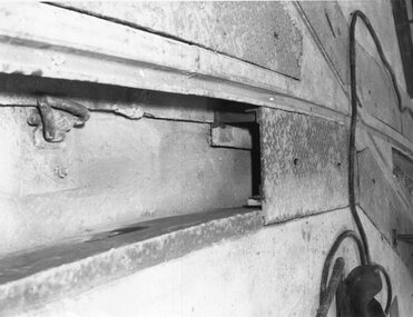
Series of 5 black and white photographs of the trackwork used at specific locations:\ .1 - plated curve of embedded plates for spandrel clips retaining the rails - would have allowed access. .2 - joint between rails - bridge expansion? In a temporary position. .3 - track being laid over a rail based bridge deck. .4 - track being laid or positioned for a bridge or replacement - possible slot beam and cable track in the background. .5 - temporary track over a bridge abutment or structure under construction.trams, tramways, trackwork, rails, track materials, track repairs, sleepers, equipment, bridges -
 Melbourne Tram Museum
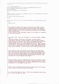
Letter, Bob Vanselow, Chris Tasker, Warren Doubleday, "Spencer St Tram track renewals", 28/04/2011 12:00:00 AM
E-mail - set of 5 sheets and six different emails between Bob Vanselow, Chris Tasker (at the time with GHD) and Warren Doubleday discussing trackwork renewals in Melbourne. The top sheet outlines the career of Bob Vanselow with the MMTB, giving details of the papers and other documents he worked on. Bob died suddenly 19-2-2019 in Timboon. Gives details of the various tram track structures in Melbourne, including sleepers or ties and methodologies. Refers to the paper by Bob Vanselow - see Reg Item 2269.trams, tramways, trackwork, mmtb, spencer st, new track, reports, planning -
 Melbourne Tram Museum
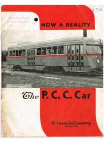
Pamphlet, St Louis Car Company Missouri, Now a Reality - The PCC car", late 1930's?
Sixteen (16) page booklet or pamphlet, centre stapled, black and white photographs with bold red overprinting in heading and company name. Produced by the St Louis Car Company Missouri. Gives the background to the Presidents Conference Committee (PCC) type streetcar or tramcar, St Louis Car Company involvement, has photos of the first car on the front cover (1001), photos of interior, drawings, doors, copy of letters dated 1936, details of structure, construction, PCC truck, body details, equipment and general dimensions.Has AETA stamp on front cover with the letters "4J31" in ink as well.trams, tramways, pcc, transport equipment, tramcars, usa -
 Federation University Art Collection
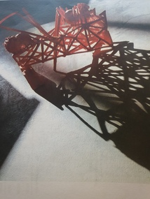
Ceramic - Artwork - Ceramics, 'Parliament House' by Pattie Beerens, 2018
Pattie BEERENS (1962- ) Born Sunshine, Victoria Pattie Beerens was enrolled in the Graduate Diploma of Ceramics at Federation University in 2018 after completing a Graduate Certificate Visual Art at the Victorian College of Arts, University of Melbourne in 2017.Artists' Statement: Red. Broken structure on its side supported with an unrecognisable form. It is cast from an electronics packaging carton. Triangular arrows piece the structure with a spider on either side. I created fertility spiders to protect the Minoan women from predators. I collected spiders as a child to ward off the bullies and, like the octopus, spiders have eight legs and a head and body. The stylised spiders reference links between the Minoan octopus and other symbols of fertility. The natural light elongates the form in a shadow reflection on the floor. The form is surrounded by black space. This piece took on an anger I felt on the day that [Malcolm] Turnbull was overthrown and materialises the bully-boy behaviour we were witnessing. What is most interesting about this piece is that I created it as a Minoan reflection. It dawned on me , when I had it ready for the kiln - on the day that Dutton challenged the Turnbull leadership, that my anger was both reflective and contemporary because nothing seemed to have changed. We were witnessing first hand how the power struggles continue and goodwill suffers." Winner of the 2018 Deputy Vice-Chancellor's Awardpattie beerens, ceramics, sculpture, available ceramics -
 Kiewa Valley Historical Society
Photographs – Set of 4 black and white photographs. One of a wooden church and three of rural homes and farmland. Area not identified
Europeans arrived in the Kiewa and Ovens Valleys in the 1830's and 40's. Following the drought of 1838-44, seeking out the rich pastures in the fertile Valleys. It proved to be perfect conditions for dairy farming and the raising of cattle. Miners Cottages and other similar wooden structures were a common sight in the area as they were a modest form of accommodation for their period, were quick to erect and economical as they made use of locally available building materials such as local timbers.These photographs provide a snapshot into the early dwellings and architecture of the Kiewa and Ovens Valley regions, including buildings such as the church, which provided an important gathering place for social interaction, especially in these isolated areas.1-Wooden church building with no identification. Large tree in the foreground in front of church 2&3- Black and white photographs of farmland and assorted dwellings, mostly miners style cottages in a valley with mountains in the background. A bridge with wooden railings is visible over the river in the middle of the photograph, also a more modern dwelling is visible in the north east of the photograph close to the river. 4-Black and white photograph of residential homes and farmland with an unsealed road running through the middle. Foreground shows a field which has been semi cleared of trees (stumps remaining). In the background are larger farming properties with the road disappearing into the distant hills. This might be Old Tallangatta before the town was moved in 1956. 1-3 - No inscriptions 4- Signature written on back in lead pencil - Sandra Templebuildings; church; farmland -
 Federation University Historical Collection
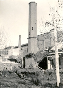
Photograph - Photograph (black & White), Ballarat School of Mines from Albert Street, c1936
The Ballarat School of Mines was the first of its type in Australia. The Albert Street frontage was the 'working end' of the campus with the mining laboratory, gauge tower and caretakers cottage. All the structures in the foreground have been demolished to make way for the Flecknoe Building and the M.B. John Building. Harry Brew, the well known Ballarat School of Mines caretaker, lived in the small weatherboard building to the right of the photograph. He was appointed to the staff at the Ballarat School of Mines in 1936.Black and white photograph showing the Ballarat School of Mines from Albert Street. Henry Richards Caselli's Gauge Tower is in the foreground. To its left is the Mining Laboratory, and to it's right is the caretakers cottage.verso 'SMB. Albert St frontage, showing (Harry Brew's) edge of his cottage. harry was a likeable character in his day, he was an old sailor boy, served, on HMAS Physice, & was an expert in , bugs and such like, crawling beasties (signature undecipherable)ballarat school of mines mining laboratory, caretaker's cottage, harry brew, henry caselli, hr caselli henry richards caselli -
 Federation University Historical Collection
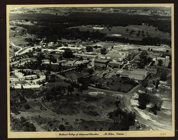
Photograph - Photograph - Black and White, Ballarat College of Advanced Education, Mt Helen - 1985, 1985
Photograph of the early years of the Ballarat College of Advanced Education at Mt Helen. On the left is the first stage of the student accommodation with a bridge connecting it to the campus. The car park located near the lakes is next to the Physical Education building. This is before the swimming pool has been added. The building with large white external structure is the E.J.Barker Library before the top floor has been built. This floor is where the Geoffrey Blainey Research Centre is housed.Photograph mounted on heavy white card which is then mounted onto black board. Aerial photograph of Ballarat College of Advanced Education at Mt Helen.ballarat college of advanced education, student accomodation, physical education, swimming pool, e j barker library, geoffrey blainey research centre, student residences -
 Federation University Historical Collection
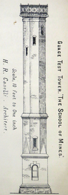
Architectural Plan, Ballarat School of Mines Gauge Tower Architectural Plan, c1883
The Ballarat School of Mines was the first of its type in Australia. The Albert Street frontage was the 'working end' of the campus with the mining laboratory, gauge tower and caretakers cottage. All the structures in the foreground have been demolished to make way for the Flecknoe Building and the M.B. John Building. Harry Brew, the well known Ballarat School of Mines caretaker, lived in the small weatherboard building to the right of the photograph. He was appointed to the staff at the Ballarat School of Mines in 1936.Printed copy of an architectural plan for the Ballarat School of Mines Gauge Tower as printed in the 1879 Ballarat School of Mines Annual Report.henry caselli, henry richards caselli, architectural plan, ballarat school of mines, gauge tower -
 National Wool Museum
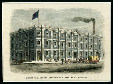
Newspaper Cutting, Messrs. C. J. Dennys and Co.'s New Wool Store Geelong, 10/9/1872
The Denny Lascelles Wool Warehouse was the first building in Victorian planned to facilitate storage, inspection and marketing of wool in one operation, and upon completion was the second largest store in the colony. CJ Denny's was largely responsible for establishment and development of the wool marketing industry in Geelong and is a figure of significance in the history of settlement in Geelong. The wool store, a basalt structure with cement rendered ornamentation, was erected for CJ Denny's and Co, in 1872 to the design of Jacob Pitman, Architect.Wood cut engraving of the Mesrs. C. J. Dennys and Co.'s New Wool Store Geelong, published in The Illustrated Australian News, 1872. The half page full colour illustration shows the newly constructed Wool Store with a bull drawn cart carrying full wool bales situated out the front of the store.Top margin: THE ILLUSTRATED AUSTRALIAN NEWS 201 Below image: Mesrs. C. J. Dennys and Co.'s New Wool Store Geelong Image signed, lower mid edge: WINSTON Image, on building: C.J. Dennys Wool Brokers 1872 C.J. Dennys & Co. Wool & Produce Warehousedenny lascelles wool warehouse, wool, dennys, wool store -
Australian Nursing & Midwifery Federation
44-minute video documentary on 1986 Victorian nurses strike, Running out of patience : the 1986 Victorian nurses strike, 1988
In October 1986, Victorian nurses began an historic strike action which was to last 50 days. This video is the nurses version of the dispute. Despite widespread condemnation mainly from the media, the nurses eventually won out for an appropriate career structure including significant pay increases. Actual strike footage together with nursing training films and old photographs explore vocational stereotypes and place the strike in the context of the current crisis in the health care system.44 minute video file (.mp4 multimedia format), transferred from original videocassette. In colour, with sound. Original was released with a booklet explaining the broader context for the documentary.labor, labour history, nurses, royal australian nursing federation, strikes, industrial action, film, trade unions, 1986 victorian nurses strike, nursing, strike action, unionism, campaigning, victoria, health system, staffing, australia, irene bolger, strikes and lockouts, history -
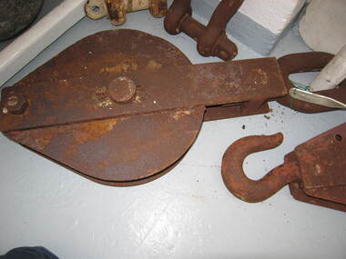 Parks Victoria - Wilsons Promontory Lightstation
Sheave Block/Pulley
Pulleys were used to lift goods to and from boats and at other sites at the lightstation where hauling was undertaken. Historical images and text panels in the Wilsons Promontory Museum attest to the detailed logistics that needed to be exercised in lifting and transporting goods once they had arrived by boat at the Eastern Landing. Cranes and a flying fox were employed in the nineteenth century and updated versions of this equipment served well into the twentieth century. The first cranes to be employed at the site were built just after December 1857, when tenders were called to construct two cranes prior to the commencement of building the lightstation.The first boat landing at the promontory was built on the west side of the lighthouse, which the architect, Charles Maplestone sketched in June 1859, the same month that he announced the completion of the lighthouse. His drawing shows one of the cranes as a large structure built for heavy duty lifting. Soon the east landing became the preferred place for delivering stores, but as late as 1993 a crane, timber structures and disused heavy iron machinery remained at the old site.Large rusted iron pulley, large loop at one end and smaller loop at the other. No hook.(Sheave Block) -
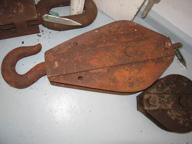 Parks Victoria - Wilsons Promontory Lightstation
Sheave block/ pulley
Pulleys were used to lift goods to and from boats and at other sites at the lightstation where hauling was undertaken. Historical images and text panels in the Wilsons Promontory Museum attest to the detailed logistics that needed to be exercised in lifting and transporting goods once they had arrived by boat at the Eastern Landing. Cranes and a flying fox were employed in the nineteenth century and updated versions of this equipment served well into the twentieth century. The first cranes to be employed at the site were built just after December 1857, when tenders were called to construct two cranes prior to the commencement of building the lightstation.180 The first boat landing at the promontory was built on the west side of the lighthouse, which the architect, Charles Maplestone sketched in June 1859, the same month that he announced the completion of the lighthouse.His drawing shows one of the cranes as a large structure built for heavy duty lifting. Soon the east landing became the preferred place for delivering stores, but as late as 1993 a crane, timber structures and disused heavy iron machinery remained at the old site.Large iron pulley with loop at one end and hook at the other, rusted. -
 The Beechworth Burke Museum
Photograph, c. 1927 - 1930
Taken during the construction of the Bethanga Bridge (1927-1930), this sepia photograph shows a view of the incomplete bridge taken from inside the structure and looking down the span of the bridge from where the photographer stands. The photograph depicts an incomplete deck, with loose-looking wooden planks/panels lain along the centre in groups of three. Once complete, the original decking of the bridge was made of timber before being replaced by cement in 1961 (Victorian Heritage Database).Bethanga Bridge is of historical significance to the Indigo Shire for its associations with the construction of Hume Dam, its associations with the River Murray Waters Agreement and the River Murray Commission, and illustration of the needs and influence of the farming communities along the river in this area - particularly in relation to the building of the Weir. It also represents the collaboration between New South Wales and Victoria on a large infrastructure project, being the only built structure shared by both New South Wales and Victoria due to its location. also reflecting on the Shire's geographical closeness to this neighboring state. This photograph is part of a series that documents the construction of this well-known heritage site of significance to the Indigo Shire. It reflects upon a period of growth and change in the area.Sepia, rectangular photograph printed on matt photographic paper, unmountedReverse: 1997.3190 / Another snap of the bridge. taken on the bridge showing huge steel sides / 84-19-4 / V [in circle] 354 / KODAK PRINTbethanga bridge, hume dam, bridges album, construction, road construction, hume weir -
 City of Ballarat
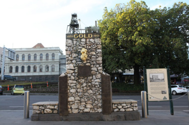
Artwork, other - Public Artwork, The Pioneer Miner's Monument, 1951
The Pioneer Miners’ Monument marks the very first finding of gold at Poverty Point in 1851. The quartz structure features a replica of the 62.8kg Welcome Nugget – the world’s largest at the time, found in Ballarat in 1858. The original was once displayed, and local mothers would sit their babies on top for luck. The artwork tells the story of gold discovery with plaques and dates of some of the more famous gold nuggets finds in Ballarat and is a reminder that these gold discoveries changed the world for Australians. The monument is of aesthetic and historical significance to the people of BallaratFitted copper miniature poppet head set atop a rough made plinth in Quartz and concrete mortar. A copy of the Welcome Nugget (Ballarat) is affixed to the front of the memorial. Includes several plaques listing the nuggets, the companies involved, the shop that paid for the last repair. THIS MONUMENT WAS ERECTED/ BY THE BALLARAT HISTORICAL/ SOCIETY TO COMMEMORATE THE/ FINDING OF GOLD AT POVERTY/ POINT 21ST AUGUST 1851 AND IS/ DEDECATED TO THE MEMORY OF/ PIONEER MINERS OF BALLARATgold, ballaraat, gold rush -
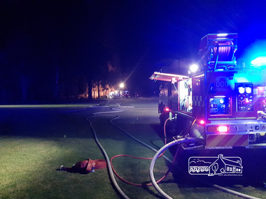 Eltham District Historical Society Inc
Photograph, Anthony Owen, Arson fire in early hours of the morning destroys the Adventure Playground at Eltham North, 16 December 2017
A community group project steered by Bambi McLean led to the construction of the Eltham North Adventure Playground which opened off Wattletree Road in 1995. The structure was mainly wooden and included an undercover element with slides and areas to climb. It was destroyed by fire in the early hours of 16 December 2017. These phtoos were taken at approx. 2am on the morning of 16 December 2017 by 2nd Lieutenant Anthony Owen of Eltham Fire Station. A new adventure playground was built in 2018.Digital fileeltham north, north eltham adventure playground, arson, wattletree road, fire engine, eltham fire brigade, eltham fire station, eltham cfa -
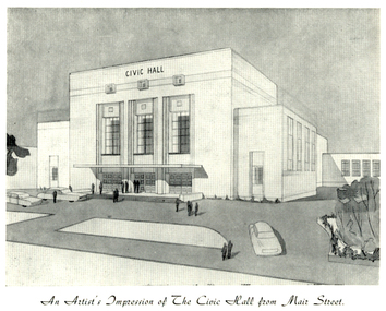 Federation University Historical Collection
Programme, The Opening of Civic Hall, 1956, 1956
The City of Ballarat unanimously resolved to erect a Civic Hall in Mair Street in 1951. The architects, Gordon Murphy, of Melbourne, and H.L. and L.J. Coburn, of Ballarat, were commissioned in 1952. The Council constructed the foundations and footings for the building under the supervision of the former City engineer, Mr L.H. Finch, in 1953. These footings are of massed concrete. The design for the building took advantage of the cross fall of the land, providing for the Small Hall to be entered from the Doveton Street frontage through a foyer under the Main Stage, the structure is steel with brick panels, with accommodation for 1,592 persons in the Main Hall and 440 persons in the Lower Hall. The front facade faces Mair Street, set back from the building line to provide for the entrance drive-ways and kerbed gardens. Tenders were invited on a firm price basis. A young Ballarat master Builter, Walter Benbow Trahar was the successful tenderer, the contract price being 139,841 pounds. the work was commenced in 1953 and has proceeded in spite of material and labour difficulties until its completion. The following statistics are of interest:- * The foundations contained 200 cubic yards of concrete. * The constructional steel work weighs approximately 270 tons. * The reinforcing steel 47 tons. * Reinforced concrete in the structure, 1,100 cubic yards. * The approximate number of bricks in the building, 580,000. * The flooring is of selected kiln-dried hard wood and totals 40,000 lineal feet. * The dimensions of the Main Auditorium, 100ft by 86 ft, including the side promenades each 82ft by 13ft. *The Main stage, of reinforced concret with parquette finish measures 62 ft by 40ft. *The floor area of the Lower Hall is 74 ft by 38 ft, and has a stage dimensions of 40ft by 20 ft. * Each hall has independent heating and ventillating systems. Where possible the material in the building was furnished from local business houses. The public address installation, which provided for additional microphones, is on the main Stage. There is inter-communication throughout the building connecting the front office, with the bioscope box, the stages in both the large and lower halls, and the Hallkeeper's residence. Local craftsmen have completed the painting, plaster work, and the electrical installation; local produced materials being used in the construction of the buildings with the exception of the timber for the Main Floor, the roofing and the structural steel. The City of Ballarat Councillors in 1956 were Councillors N. T. Callow, F.J. Cutts, K.C. Webb, W.E. Roff, O.W. Curnow, F.T. Woodward, Allan C. Pittard, A.W. Nicholson, J.A. Chisholm, G.L. Scott, F.W. Oliver, A.D. Mason. The Town clerk was H.R. Maddern and the City Engineer was G. Murrowood. A City of Ballarat Council meeting of 25 September 2013 voted to demolish the Ballarat Civic Hall. The Council heard from nearly 50 members of the public during a marathon six-hour meeting. Councilors John Birt, Des Hudson, Amy Johnson, Josh Morris, Peter Innes, John Philips supported the motion to demolish Civic Hall. Councillors Samantha McIntosh, Vicki Coltman and Belinda Coates voted against the motion.Six page souvenir Program of citizens' entertainment on the occasion of the Opening of Ballarat Civic Hall on in August 1956. The front cover features the City of Ballarat Coat of Arms. The programme starts with a message from the Mayor, Cr Neil T. Carrow. It includes the Concert Programme directed by James H. Davey, an asrtist's impression of the Civic Hall from Mair Street, and information relative to the New Civic Hall. The programme features images of the City of Ballarat Coat of Arms, Cr N.T. Callow, , James H, Davey, and an artist's impression of the Ballarat Civic Hall. Mayor Neil Callow's Message: "To-day, our citizens witness the fulfilment of the most extensive Municipal undertaking in the City's period of recent prosperity and development. Their Hall now fills a requirement of which they have been deprived since the Coliseum building was destroyed by fire over 20 years ago. The building has been designed as an all purpose structure and I am hopeful the citizens will use it and enjoy it to its fullest extent. Your Council and its Architects have planned as broadly as possible for the benefit of all to-day and for years to come. We are proud of the work executed by a Ballaarat Master Builder whose work is a monument to the City's craftsmen. I feel I should also remind this assembly that the women of Ballaarat, back in 1951, provided funds which have been applied in the purchase of a Grand Piano and two Upright Pianos which are now installed in this building. The sincere hope of myself and your Councillors is that this Hall and its amenities will prove of immense value to the development of the cultural and artistic tastes of this community and that it will be freely used for these and many other purposes. From now on this magnificent building and its furnishings and equipment will be available to all. I strongly exhort you to use and protect it. My hope is that the citizens will, for many years to come, enjoy the amenities which it has to offer. ballarat civic hall, civic hall, architecture, finch, art deco, city of ballarat, coat of arms, city of ballarat coat of arms, callow, shugg, lemke, oates, gullan, tuuri, john, robertson, sorrell, antonio, gordon murphy, walter benbow trahar, trahar, coburn, h.l. coburn, l.j. coburn, n.t. callow -
 Bendigo Historical Society Inc.
Document - CAROL HOLSWORTH COLLECTION: GEOLOGICAL REPORT BENDIGO GOLDFIELD
Four page document, an extract from the Geological Report on the Bendigo Goldfield. On front page, a line drawing of a puddling machine. Contents include: alluvial mining, reef mining, the boom years, deep sinking, decline of mining, modern exploration, physiography, the hills, the valleys and the soils. A table demonstrates the development of graptolite structures, including the Lancefieldian, Bendigonian, Chewtonian and Castlemainian graptolite species. Two diagrams demonstrate saddle and bedded reefs and fault reefs. Written on top of the document: C.E. William and H.E. Wilkinson, 1992. Geological Survey Report No. 93.bendigo, mining, geological bulletin 93 -
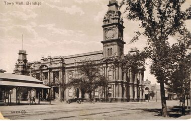 Bendigo Historical Society Inc.
Postcard - TOWN HALL, BENDIGO
black and white photo: image shows Town hall, Bendigo, taken looking southward along Hargreaves Street, approx. 1920's ? Car in centre of image is open top, white wall tyres. Structure on LH side of photo has verandah and appears to be 'open' type of building underneath roofline, Bendigo Market place.To the right of the Town Hall is the north end of a market building, which stood where the Bendigo Library now stands. On rear of card ' printed in Great Britain, The Valentine & Sons Publishing Co., Ltd., Melbourne.'Valentine & Sonsbendigo, buildings, town hall, bendigo, bendigo, town hall, hargreaves street -
 Australian Gliding Museum
Machine - Glider – Sailplane, 1939
This Dunstable Kestrel glider (which originally was finished in silver paint) was built in 1939 by Ric New and members of the Lake Pinjar Soaring Club. It first flew on 26 December 1939 at Lake Pinjar. The first extensive flight was on 7 January 1940 when Ric New managed to stay aloft for 30 minutes and reach a height of 3000 metres. Unfortunately the Kestrel was badly damaged the same day when another club member Jim Brabazon stalled and spun in. The Kestrel was repaired by June 1940 and flown extensively at Lake Pinjar in 1940 and 1941 until Government authorities intervened and ploughed up Lake Pinjar as a wartime measure to prevent it being used as a landing field by the enemy [Allan Ash, Gliding in Australia, pp 92 – 94]. The Lake Pinjar Soaring club was reformed as the Perth Gliding Club after the end of the war and was joined by Ric New with his Kestrel [Allan Ash, Gliding in Australia, p 103]. The glider was held in storage at the Gliding Club of Western Australia prior to transfer to the Australia Gliding Museum. The Deed of Gift indicates that it was formerly owned by Wally Williams, also from Western Australia. The aircraft is in poor condition and has some non-original elements. It is one of three that currently exist. Nevertheless it is considered to be an important exhibit for relating the history of gliding in Western Australia.Aircraft of wood structure skinned with plywood and fabric – off-white colour scheme – crazed flaking paint on fuselage – nose of fuselage has been modified by addition of streamlining – damage includes impact holes to plywood, especially on starboard side – wings have been stripped of fabric covering and some ribs are missing – tailplane and rudder are in reasonable condition although, like wings, have been stripped of fabric. Overall, while the main elements of this aircraft are present, there are a number of missing fittings and will require extensive works to restore to a static display standard.australian gliding, glider, sailplane, dunstable, kestrel, bill manuel, ric new, lake pinjar soaring club, lake pinjar, gliding club of western australia -
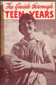 Bendigo Historical Society Inc.
Book - AILEEN AND JOHN ELLISON COLLECTION: BOOKLET - THE GUIDE THROUGH TEEN YEARS
Small booklet (36 pages) "The guide through teen years". Published by Father and son welfare movement of Australia. Fifth edition November, 1957. Contents - Foreword. Introduction. Part 1; Your body. Chapter 1: its structure. Chapter 2: menstruation. Chapter 3: the miracle of human birth. Part 2; Your maturing mind. Chapter 1: your changing outlook. Chapter 2: independence and sex. Chapter 3: vocation and religion. Part 3; Your quest. Postscript: some practical helps to young womanhood.books, school, sex education -
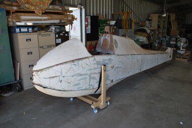
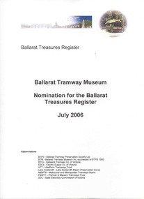 Ballarat Tramway Museum
Document - Report, Ballarat Tramway Museum (BTM), "Ballarat Treasures Register", 25/07/2006 12:00:00 AM
Yields information about the views of the BTM as to the significance of the tramcars and infrastructure in Ballarat for submission to the City of Ballarat.Ballarat Tramway Museum's submission dated 25 July 2006, to the City of Ballarat titled "Ballarat Treasures Register". Bound within a black plastic spiral folder with plastic sheets containing the individual sheets. Contains - covering letter to the City of Ballarat Cover sheet and nomination form for: Sturt St - section of tram track and track to the Phoenix Foundry and photographs Horse Tram No. 1 ESCo No. 12 SEC 14 SEC 18 SEC 26 SEC 27 SEC 38 SEC 40 Wendouree Parade - track and overhead structuretrams, tramways, ballarat treasures, btm, wendouree parade, tramcars -
 Kew Historical Society Inc
Photograph - Zig-Zag Bridge on the Yarra River at Kew, 1924
Henry Beater Christian (1886-1962) , was a descendant of one of the earliest settler families in Kew. Employed at the Kew Asylum as a 'public servant', he was a skilled amateur photographer, photographing numerous scenes in Kew and on his travels around Victoria. The majority of his photographs date from 1916 to 1929. His finest photographs are housed in two photograph albums. Digital copy of a photograph from page 8 of the 47-page photograph album containing 261 gelatinous silver images, loaned by Diane Washfold with permission given to digitise and hold a copy in our collection. The Zig-Zag Bridge linked the grounds of the Yarra Bend and Kew Asylums. The wooden bridge was constructed in the 1870s and lasted through numerous floods until its destruction in 1929. A horizontal structure, the walkway was reached via a wooden staircase on the Kew side. The steps were required due to the different levels of the banks on this stretch of the river. "Zig-Zag Bridge"henry beater christian (1886-1962), landscape photography, kew (vic.) — yarra river, christian-washfold collection, photograph albums, zig-zag bridge -
 Kew Historical Society Inc
Map, MMBW, MMBW Town of Kew, 1910-21
The Melbourne and Metropolitan Board of Works (MMBW) was established by an act of the Victorian Parliament in 1890 to prepare for and to implement a sewerage and water reticulation system across what was then inner Melbourne, its surrounding and middle distance suburbs, including Kew. The MMBW was disbanded in 1991.The map collection of the Kew Historical Society has at its core the historic maps assembled and originally stored in the City Engineer's Department of the City of Kew. These include maps in a number of scales. The vast majority of maps were produced by the MMBW in the first two decades of the twentieth century, and are solid working maps, backed by linen for durability. These maps are historically significant to Kew, the City of Boroondara and to the history of the development of state utilities in Victoria. A number of the Kew maps have additional details added by former municipal officers, including the levels reached by various floods. As these were working documents, information was added to them long after the period of their initial production and distribution.Early map of the Town of Kew, created after 1910, at a scale 440 ft to 1 inch. The 'assembled' map by the City of Kew Engineer's Department includes scaled down copies of The Melbourne and Metropolitan Board of Works maps, Nos. 39, 40, 64, 65, 66, 67, 68, and 117. The map covers the entirety of the Town of Kew, bordered on its north and west by the River Yarra, by Burke Road in the East and Barkers Road in the south. The map shows the extent of urban development by that time, prominent institutions and the outlines of built structures in the municipality. TOWN OF KEW / SCALE 400 FEET TO 1 INCHmelbourne & metropolitan board of works, mmbw maps, mmbw plans, town of kew, cartography -
 Kew Historical Society Inc
Map, MMBW, MMBW Plan No.40 Collingwood & Kew, 1900-1910
The Melbourne and Metropolitan Board of Works (MMBW) was established by an act of the Victorian Parliament in 1890 to prepare for and to implement a sewerage and water reticulation system across what was then inner Melbourne, its surrounding and middle distance suburbs, including Kew. The MMBW was disbanded in 1991.The map collection of the Kew Historical Society has at its core the historic maps assembled and originally stored in the City Engineer's Department of the City of Kew. These include maps in a number of scales. The vast majority of maps were produced by the MMBW in the first two decades of the twentieth century, and are solid working maps, backed by linen for durability. These maps are historically significant to Kew, the City of Boroondara and to the history of the development of state utilities in Victoria. A number of the Kew maps have additional details added by former municipal officers, including the levels reached by various floods. As these were working documents, information was added to them long after the period of their initial production and distribution.Early map of part of the Borough of Kew, created in the first decade of the twentieth century, at a scale 160 ft to 1 inch. The map covers what was then the south western section of Kew, bordered on its north by Studley Park Road, in the west by Walmer Street and the River Yarra, by High Street South and Princess Street in the East and Barkers Road in the south. The map shows the extent of urban development by that time, prominent institutions and the outlines of built structures in the municipality. Contour lines and historic flood levels were added in ink to the map at a later stage.MELBOURNE AND METROPOLITAN BOARD OF WORKS / PLAN NO. 40 / COLLINGWOOD & KEWmelbourne & metropolitan board of works, mmbw maps, mmbw plans, borough of kew, cartography -
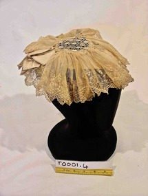 Brighton Historical Society
Headwear - Hat, Headdress, Late 1800s
A lace head dress belonging to the women of the family of George Ward Cole’s in the late 1800s. George Ward Cole was an early member of the Victorian Parliament and the family featured prominently in Melbourne Society in their time. They established a substantial home known as “St Ninians” at 10 Miller Street in 1841. The family reportedly entertained Melbourne’s first Royal visitor the Duke Of Edinburgh, Queen Victoria’s second son, at St Ninians in 1867. In later years St Ninians was subsequently subdivided and later demolished. A hand sewn cream lace cap from late 1800s. A silk satin ribbon that encircles the back of the crown of the head, creates the structure of this cap. Towards the front it also has a net and wire-reinforced peak. Over the top of this support is a central diamond shaped lace piece of seven and a half centimeters diameter to which is attached a fine lace net that is gathered and stitched around the edge of the central lace. Two decorative bows of the same silk satin fabric are positioned on the support over the top of the lace at either temple of the wearer. "W-COLE" hand stitched on inside of band. It is unknown when and by whom this inscription was made.st ninians, george ward cole, headwear, late 1800s, brighton, margaret morrison ward cole, agnes bruce ward cole, thomas anne ward cole -
 Bacchus Marsh & District Historical Society
Photograph, Cheese Factory Waddell Street Bacchus Marsh 1883
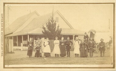
The Cheese Factory in this image was opened around 1879 by Mr. G.G. Pearce. It was in Waddell Street. It was one of the first cheese factories in Victoria. It was later owned and operated by William Telford with the assistance of John Mahon. The factory was described in the Bacchus Marsh Express newspaper as an important business and service for the region. G.G. Pearce was reported to have spent a good deal of money in setting up the factory to ensure it was one which produced high quality cheese using modern methods of production. The factory was sold in 1889 to a Mr. H. W. King who was from Abbotsford in Melbourne. Unfortunately within a few days of Mr King buying the factory it was completely destroyed in a fire. All that was left were two large pine trees and two large underground concrete tanks.G.G. Pearce was described as a pioneer of cheese factories in Victoria. His first factory was just outside of Bacchus Marsh at Hopetoun. Around 1879 he moved into Bacchus Marsh and opened a new purpose built factory in Waddell Street. The Bacchus Marsh Express newspaper reported that no expense had been spared in constructing this factory. The factory was completely destroyed in a fire in 1889 which makes it fortunate that this image was captured of this early cheese factory in Victoria.Small sepia unframed photograph on card with gold border framing photograph. Housed in the album, 'Photographs of Bacchus Marsh and District in 1883 by Stevenson and McNicoll'. The image shows a group of men and women standing in a row in front of the Bacchus Marsh Cheese factory. One of the women is holding a small child. In front of another woman stands a young boy. Behind them is a covered wagon with a man seated upon it. Some of the men and women are wearing long aprons. In the background is the Cheese Factory. It is a large wooden structure with a high and steep pitched roof.On the front: Stevenson & McNicoll. Photo. 108 Elizabeth St. Melbourne. COPIES CAN BE OBTAINED AT ANY TIME. On the back: LIGHT & TRUTH inscribed on a banner surmounted by a representation of the rising sun. Copies of this Portrait can be had at any time by sending the Name and Post Office Money Order or Stamps for the amount of order to STEVENSON & McNICOLL LATE BENSON & STEVENSON, Photographers. 108 Elizabeth Street, MELBOURNE stevenson and mcnicoll 1883 photographs of bacchus marsh and district, cheese factories, bacchus marsh cheese factory -
 Bacchus Marsh & District Historical Society
Photograph, Simpsons Butchery Main Street Bacchus Marsh 1883
John Simpson arrived in Bacchus Marsh around 1848. In 1850 he established a butchery business. He continued to operate this business in Main Street Bacchus Marsh until his death in 1890. His son John Simpson and one of his brothers, Edward took over the business and operated it until 1923. John Simpson the younger died in 1940 having lived all but a few months of his 92 years in Main Street Bacchus Marsh. Edward L. Simpson died in Corowa, NSW in 1937. The younger John Simpson's recollections of Bacchus Marsh in the 1850s to 1870s were published in the Bacchus Marsh Express on the 25 June 1932.Small sepia unframed photograph on card with gold border framing photograph. Housed in the album, 'Photographs of Bacchus Marsh and District in 1883 by Stevenson and McNicoll'. The image shows a butchery shop in Main Street Bacchus Marsh in 1883. The front of the building is shown. It is a solid brick or stone structure with a shingled roof and verandah. Hanging under the verandah are numerous carcasses and portions of meat. Two men are standing close together in front of the shop. One is wearing a butcher's apron. Another man to the left sits upon a horse. In the doorway behind the men stands a woman. On the front: Stevenson & McNicoll. Photo. 108 Elizabeth St. Melbourne. COPIES CAN BE OBTAINED AT ANY TIME. On the back: LIGHT & TRUTH inscribed on a banner surmounted by a representation of the rising sun. Copies of this Portrait can be had at any time by sending the Name and Post Office Money Order or Stamps for the amount of order to STEVENSON & McNICOLL LATE BENSON & STEVENSON, Photographers. 108 Elizabeth Street, MELBOURNE. stevenson and mcnicoll 1883 photographs of bacchus marsh and district, butcher shops, butchers, john simpson butcher 1848-1940, john simpson butcher died 1890