Showing 2399 items matching " structure"
-
 Kew Historical Society Inc
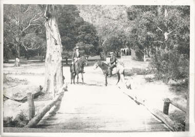
Photograph - Zig-Zag Bridge on the Yarra River at Kew, 1924
Henry Beater Christian (1886-1962) , was a descendant of one of the earliest settler families in Kew. Employed at the Kew Asylum as a 'public servant', he was a skilled amateur photographer, photographing numerous scenes in Kew and on his travels around Victoria. The majority of his photographs date from 1916 to 1929. His finest photographs are housed in two photograph albums. Digital copy of a photograph from page 8 of the 47-page photograph album containing 261 gelatinous silver images, loaned by Diane Washfold with permission given to digitise and hold a copy in our collection. The Zig-Zag Bridge linked the grounds of the Yarra Bend and Kew Asylums. The wooden bridge was constructed in the 1870s and lasted through numerous floods until its destruction in 1929. A horizontal structure, the walkway was reached via a wooden staircase on the Kew side. The steps were required due to the different levels of the banks on this stretch of the river. "Zig-Zag Bridge"henry beater christian (1886-1962), landscape photography, kew (vic.) — yarra river, christian-washfold collection, photograph albums, zig-zag bridge -
 Kew Historical Society Inc
Map, MMBW, MMBW Town of Kew, 1910-21
The Melbourne and Metropolitan Board of Works (MMBW) was established by an act of the Victorian Parliament in 1890 to prepare for and to implement a sewerage and water reticulation system across what was then inner Melbourne, its surrounding and middle distance suburbs, including Kew. The MMBW was disbanded in 1991.The map collection of the Kew Historical Society has at its core the historic maps assembled and originally stored in the City Engineer's Department of the City of Kew. These include maps in a number of scales. The vast majority of maps were produced by the MMBW in the first two decades of the twentieth century, and are solid working maps, backed by linen for durability. These maps are historically significant to Kew, the City of Boroondara and to the history of the development of state utilities in Victoria. A number of the Kew maps have additional details added by former municipal officers, including the levels reached by various floods. As these were working documents, information was added to them long after the period of their initial production and distribution.Early map of the Town of Kew, created after 1910, at a scale 440 ft to 1 inch. The 'assembled' map by the City of Kew Engineer's Department includes scaled down copies of The Melbourne and Metropolitan Board of Works maps, Nos. 39, 40, 64, 65, 66, 67, 68, and 117. The map covers the entirety of the Town of Kew, bordered on its north and west by the River Yarra, by Burke Road in the East and Barkers Road in the south. The map shows the extent of urban development by that time, prominent institutions and the outlines of built structures in the municipality. TOWN OF KEW / SCALE 400 FEET TO 1 INCHmelbourne & metropolitan board of works, mmbw maps, mmbw plans, town of kew, cartography -
 Kew Historical Society Inc
Map, MMBW, MMBW Plan No.40 Collingwood & Kew, 1900-1910
The Melbourne and Metropolitan Board of Works (MMBW) was established by an act of the Victorian Parliament in 1890 to prepare for and to implement a sewerage and water reticulation system across what was then inner Melbourne, its surrounding and middle distance suburbs, including Kew. The MMBW was disbanded in 1991.The map collection of the Kew Historical Society has at its core the historic maps assembled and originally stored in the City Engineer's Department of the City of Kew. These include maps in a number of scales. The vast majority of maps were produced by the MMBW in the first two decades of the twentieth century, and are solid working maps, backed by linen for durability. These maps are historically significant to Kew, the City of Boroondara and to the history of the development of state utilities in Victoria. A number of the Kew maps have additional details added by former municipal officers, including the levels reached by various floods. As these were working documents, information was added to them long after the period of their initial production and distribution.Early map of part of the Borough of Kew, created in the first decade of the twentieth century, at a scale 160 ft to 1 inch. The map covers what was then the south western section of Kew, bordered on its north by Studley Park Road, in the west by Walmer Street and the River Yarra, by High Street South and Princess Street in the East and Barkers Road in the south. The map shows the extent of urban development by that time, prominent institutions and the outlines of built structures in the municipality. Contour lines and historic flood levels were added in ink to the map at a later stage.MELBOURNE AND METROPOLITAN BOARD OF WORKS / PLAN NO. 40 / COLLINGWOOD & KEWmelbourne & metropolitan board of works, mmbw maps, mmbw plans, borough of kew, cartography -
 Brighton Historical Society
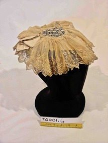
Headwear - Hat, Headdress, Late 1800s
A lace head dress belonging to the women of the family of George Ward Cole’s in the late 1800s. George Ward Cole was an early member of the Victorian Parliament and the family featured prominently in Melbourne Society in their time. They established a substantial home known as “St Ninians” at 10 Miller Street in 1841. The family reportedly entertained Melbourne’s first Royal visitor the Duke Of Edinburgh, Queen Victoria’s second son, at St Ninians in 1867. In later years St Ninians was subsequently subdivided and later demolished. A hand sewn cream lace cap from late 1800s. A silk satin ribbon that encircles the back of the crown of the head, creates the structure of this cap. Towards the front it also has a net and wire-reinforced peak. Over the top of this support is a central diamond shaped lace piece of seven and a half centimeters diameter to which is attached a fine lace net that is gathered and stitched around the edge of the central lace. Two decorative bows of the same silk satin fabric are positioned on the support over the top of the lace at either temple of the wearer. "W-COLE" hand stitched on inside of band. It is unknown when and by whom this inscription was made.st ninians, george ward cole, headwear, late 1800s, brighton, margaret morrison ward cole, agnes bruce ward cole, thomas anne ward cole -
 Bacchus Marsh & District Historical Society
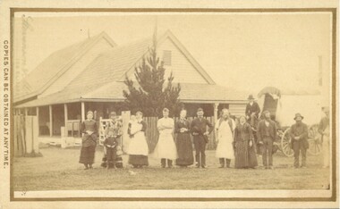
Photograph, Cheese Factory Waddell Street Bacchus Marsh 1883
The Cheese Factory in this image was opened around 1879 by Mr. G.G. Pearce. It was in Waddell Street. It was one of the first cheese factories in Victoria. It was later owned and operated by William Telford with the assistance of John Mahon. The factory was described in the Bacchus Marsh Express newspaper as an important business and service for the region. G.G. Pearce was reported to have spent a good deal of money in setting up the factory to ensure it was one which produced high quality cheese using modern methods of production. The factory was sold in 1889 to a Mr. H. W. King who was from Abbotsford in Melbourne. Unfortunately within a few days of Mr King buying the factory it was completely destroyed in a fire. All that was left were two large pine trees and two large underground concrete tanks.G.G. Pearce was described as a pioneer of cheese factories in Victoria. His first factory was just outside of Bacchus Marsh at Hopetoun. Around 1879 he moved into Bacchus Marsh and opened a new purpose built factory in Waddell Street. The Bacchus Marsh Express newspaper reported that no expense had been spared in constructing this factory. The factory was completely destroyed in a fire in 1889 which makes it fortunate that this image was captured of this early cheese factory in Victoria.Small sepia unframed photograph on card with gold border framing photograph. Housed in the album, 'Photographs of Bacchus Marsh and District in 1883 by Stevenson and McNicoll'. The image shows a group of men and women standing in a row in front of the Bacchus Marsh Cheese factory. One of the women is holding a small child. In front of another woman stands a young boy. Behind them is a covered wagon with a man seated upon it. Some of the men and women are wearing long aprons. In the background is the Cheese Factory. It is a large wooden structure with a high and steep pitched roof.On the front: Stevenson & McNicoll. Photo. 108 Elizabeth St. Melbourne. COPIES CAN BE OBTAINED AT ANY TIME. On the back: LIGHT & TRUTH inscribed on a banner surmounted by a representation of the rising sun. Copies of this Portrait can be had at any time by sending the Name and Post Office Money Order or Stamps for the amount of order to STEVENSON & McNICOLL LATE BENSON & STEVENSON, Photographers. 108 Elizabeth Street, MELBOURNE stevenson and mcnicoll 1883 photographs of bacchus marsh and district, cheese factories, bacchus marsh cheese factory -
 Bacchus Marsh & District Historical Society
Photograph, Simpsons Butchery Main Street Bacchus Marsh 1883
John Simpson arrived in Bacchus Marsh around 1848. In 1850 he established a butchery business. He continued to operate this business in Main Street Bacchus Marsh until his death in 1890. His son John Simpson and one of his brothers, Edward took over the business and operated it until 1923. John Simpson the younger died in 1940 having lived all but a few months of his 92 years in Main Street Bacchus Marsh. Edward L. Simpson died in Corowa, NSW in 1937. The younger John Simpson's recollections of Bacchus Marsh in the 1850s to 1870s were published in the Bacchus Marsh Express on the 25 June 1932.Small sepia unframed photograph on card with gold border framing photograph. Housed in the album, 'Photographs of Bacchus Marsh and District in 1883 by Stevenson and McNicoll'. The image shows a butchery shop in Main Street Bacchus Marsh in 1883. The front of the building is shown. It is a solid brick or stone structure with a shingled roof and verandah. Hanging under the verandah are numerous carcasses and portions of meat. Two men are standing close together in front of the shop. One is wearing a butcher's apron. Another man to the left sits upon a horse. In the doorway behind the men stands a woman. On the front: Stevenson & McNicoll. Photo. 108 Elizabeth St. Melbourne. COPIES CAN BE OBTAINED AT ANY TIME. On the back: LIGHT & TRUTH inscribed on a banner surmounted by a representation of the rising sun. Copies of this Portrait can be had at any time by sending the Name and Post Office Money Order or Stamps for the amount of order to STEVENSON & McNICOLL LATE BENSON & STEVENSON, Photographers. 108 Elizabeth Street, MELBOURNE. stevenson and mcnicoll 1883 photographs of bacchus marsh and district, butcher shops, butchers, john simpson butcher 1848-1940, john simpson butcher died 1890 -
 Melbourne Tram Museum
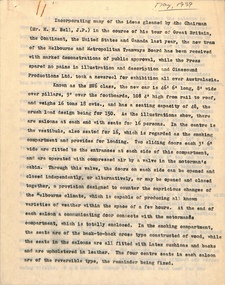
Document, Melbourne & Metropolitan Tramways Board (MMTB), Untitled - "SW6 class", May. 1939
Report - 7 quarto typed sheets - untitled, but gives a detailed description of the design basis and construction of the SW6 class tram. Dated May 1939. Details the design after Bell's overseas trip the previous year. Details dimensions, seating, ventilation, seating, doors, structure, construct, timber, materials, door engines, cab equipment, PA system, interior appearances, flooring, colours, lighting, conductor's bell / signals, trucks, bolster, wheels, brake shoes, braking, motors, acceleration, performance, controllers, contactors, compressor. Gives a detailed list of the specifications.Has a note in pencil about a typographical error on the bottom of the sheet.trams, tramways, sw6 class, specification, tramcars, tram controllers, tram equipment, tramcar design -
 Bacchus Marsh & District Historical Society
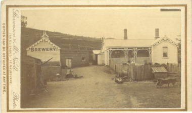
Photograph, Symington Brewery, Hopetoun, near Bacchus Marsh 1883
The family of William Symington arrived in Melbourne in 1855. By 1858 they had come to Bacchus Marsh and built a house at Hopetoun a few kilometres east of the town. A brewery next to the house was also built around this time. It was a licensed brewery between 1862 and 1886. The elder William Symington died in March 1867 and the brewery was then operated by his son the younger William Symington for a number of years. It ceased operations sometime before 1900. Small sepia unframed photograph on card with gold border framing photograph. Housed in the album, 'Photographs of Bacchus Marsh and District in 1883 by Stevenson and McNicoll'. The image shows the brewery and house which belonged to the Symington family of Hopetoun, near Bacchus Marsh. The house is a timber structure with two chimneys and a front verandah. The front yard of the house is enclosed by a timber fence. At the front of the fence can be seen a dog kennel. Other tools, such as a wheelbarrow, lie in the yard. The brewery building is of timber and brick. On the hillside behind the buildings are paddocks fenced with post-and -rail fencing.On the front: Stevenson & McNicoll. Photo. 108 Elizabeth St. Melbourne. COPIES CAN BE OBTAINED AT ANY TIME. On the back: LIGHT & TRUTH inscribed on a banner surmounted by a representation of the rising sun. Copies of this Portrait can be had at any time by sending the Name and Post Office Money Order or Stamps for the amount of order to STEVENSON & McNICOLL LATE BENSON & STEVENSON, Photographers. 108 Elizabeth Street, MELBOURNE. stevenson and mcnicoll 1883 photographs of bacchus marsh and district, breweries, symington family bacchus marsh, william symington 1840-1929, william symington 1802-1867 -
 Orbost & District Historical Society
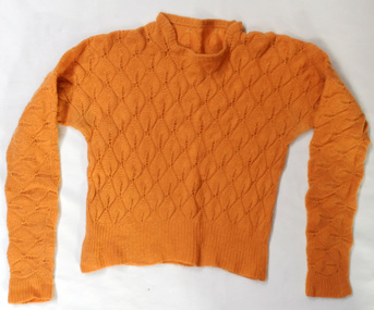
knitted jumper, 1938-1940
This was knitted by Marjorie Burton during WW11 in England. She used to knit while in an air raid shelter escaping the bombing with her young daughter. Air raid shelters were built specifically to serve as protection against enemy air raids. However, pre-existing structures such as underground stations (tube or subway stations), tunnels, cellars in houses or basements in larger establishments, and railway arches, above ground, were suitable for safeguarding people during air raids. This item is an example of a handcrafted item and reflects the handcraft skills of women necessary during WW11 when clothing became scarce. Clothes rationing began on June 1, 1941, two years after food rationing started. Clothes rationing ended on 15 March 1949.A hand-knitted orange/tan woolen jumper. It is a lady's long-sleeved jumper.handcraft knitting ww11 -
 Warrnambool and District Historical Society Inc.
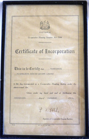
Certificate - Warrnambool Co-operative Housing Society Limited Certificate of Incorporation, 1951
Co-operative housing societies were loan societies established in the mid to late 20th century. They were based on the structure of a group of borrowers approximately 40, who lived within a radius of thirty miles joining a co-operative. They had the right to select their own site, plans and amount that they would like to spend. The co-operatives were administered by accounting firms. There were conditions placed on the borrowers in regard to amounts able to be borrowed and size of dwelling and percentage of cost which could be borrowed.The era of post-World War Two saw a shortage in a number of areas one of which was housing. The co-operative Housing scheme was preferred by many as it avoided the block approach which had been used by the Housing commission. The co-operative housing scheme proved to be of benefit to many families around that time.Framed certificate with black text Stylised frame around text. Paper is cream.H.E Daw Gov Print., Melb. Victorian Government seal in bottom Right hand corner. Registrar of Co-operative housing societies, Victoria. warrnambool, co-operative housing society 1951 -
 Warrnambool and District Historical Society Inc.
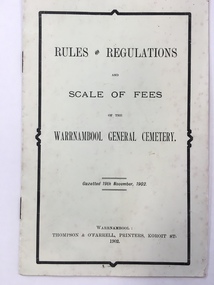
Booklet, Thompson & O'Farrell, Rules & Regulations scale of fees Cemetary, 1902 (original edition)
This booklet gives the Rules and Regulations and the Scale of Fees for the Warrnambool General Cemetery as from 1902. The booklet rescinded the Rules and Regulations of 1855 and amongst the 1902 Rules it is noted that no catacombs or wooden structures were allowed by the Trustees. It was also noted that no child under ten was permitted into the cemetery grounds unless under adult supervision. The charge for an adult burial was £1 and ten shillings for a child under ten. The Warrnambool Cemetery is in Otway Road, Warrnambool and was first gazetted in 1853 with Mr Whittet as the first Sexton. This booklet is of considerable interest because it gives the Rules and Regulations and the Scale of Charges of the Warrnambool General Cemetery as laid down in 1902. The Trustees at the time were William Ardlie, a prominent Warrnambool lawyer, Samuel Nettleton, a well-known Warrnambool shopkeeper and J.H.Allan, a member of a pioneering family in the Warrnambool district. This is a small booklet containing the Rules and Regulations of the Warrnambool General Cemetery. It contains four double-sided pages with printed material on all of the pages. The cover is pale yellow and the printing on the front cover has a black edging. There is some silverfish damage on the page edges. The pages were stapled together but the staples have been removed (the use of staples suggests that this booklet is perhaps a reprint at a later date)Front Cover: ‘Rules and Regulations and Scale of Fees of the Warrnambool General Cemetery, Gazetted 19th November 1902, Warrnambool, Thompson and O’Farrell, Printers, Koroit St. 1902’.warrnambool general cemetery -
 Wycheproof & District Historical Society Inc.
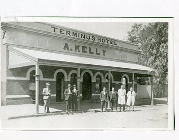
Photograph, Maker Unknown, Terminus Hotel, 1930 (estimated)
The Terminus Hotel opened in January 1884, coinciding with the opening of the railway. The hotel had a close connection with the railway, catering for travellers and relieving railway workers. In December 1903 the original wooden structure burnt to the ground. The hotel was rebuilt in 1904 in much the same form see Record No 00306. Mr Andrew Kelly of Nullawil took over the enterprise circa 1930 giving it a new look in the 'Art Deco' style of the period. Mr Kelly and family ran a successful hotel business for forty years.Copy of a B&W photograph of the Terminus Hotel, situated in Broadway Wycheproof circa 1930s. Of brick construction, featuring arch entrance doorways and windows. A verandah protects the street facade. The architecture represents the 'Art Deco' period.Nonehotel wycheproof broadway, men clothing, art deco 1930s -
 Kiewa Valley Historical Society
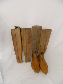
Stocks for Riding Boots, Late 1800's to early 1900's
These wooden trees for riding stocks are a concept that was brought to early colonial days from "mother" England. Gentle folk of wealth and status used these trees from early 1800's to keep and maintain their riding boots in their correct form. This form of maintaining the tall riding boot structure was maintained in Australia by the rural "elite" both on cattle properties and smaller cattle stations in the early 1900's. Good riding boots were a status symbol in rural and outback Australia. The riding stocks "wooden trees" are very significant in the Kiewa Valley because they were used by members of some of the original grazing cattle families to settle there. Both cattle and sheep properties occupied large areas of the Kiewa Valley and they also herded their flock and herd on the Bogong High Plains region. These stocks and boots were worn by Fred Roper whose great grand daughter donated them to KVHS. Therefore these boots and stocks would date from 1880's to 1920's and are a good representation of the style of boots worn during this period. This pair of wooden stocks for riding boots trees has been manufactured to a very high standard. Each of the four boot tree parts fit snugly together and maintain their form, and that of the boot that they occupy. The groove channels and foot forms (tongue and groove) are exact and once snapped together become very solid. There is a brass ring, attached by a small brass "peg" on each of the thin "sliding" middle uprights. See KVHS 0177 - Riding boots.On top "L" (for left boot), "R" (for right boot)horse. country. leather. gaiters. high plains. grazing. cattlemen. laces. studs. stocks. roper family. bogong high plains. -
 Glen Eira Historical Society
Document - BRIGHTON GENERAL CEMETERY
This file contains two brochures from the Brighton General Cemetery, one black and white dated 2013, the other in colour and undated. The first provides eight short biographies of notable writers and journalists interned at the cemetery, the other containing a map with the location of thirty-four notable internments unrelated to literature. Both provide a brief history of the cemetery with the first also including images of some of the people discussed and what appears to be the cemetery emblem. The second brochure displays a colour photograph of a structure in the cemetery.cemeteries, brighton, authors, journalists, occupations, people, documents, pamphlets, tourist leaflets, migrants, widowers, knowles marion, cambridge ada, buckley herbert, browne thomas alexander, walstab george alexander, cunningham edward sheldon, dow john lament, dexter caroline, lynch caroline, brighton general cemetery, people associated with culture, brighton cemetorians, east brighton north road, people by circumstance, knowles joseph, cross george frederick, ribbledon herbert, horseracing, equestrian events, pioneers, squatters, civil servants, police, boldrewood rolf, robbery under arms, the miner’s right, babes in the bush, communication activities, the age, the herald, the argus, edward wilson estate, burketown, the leader, walstab mary anne, nolan anne, jackson maval mary, sir graham barry ministry, dow marion jane, orr marion jane, mckenzie david, dexter william, ladies almanack: the southern cross or australian album and new years gift, institute of hygiene, lynch william, mayors, bombala, cheltenham pioneer cemetery, cheltenham memorial park, bunurong memorial park, cheltenham and regional cemeteries trust, springvale cemetery, southern metropolitan cemeteries trust, manson johanna, religious groups, groups (people), funerals, cremation, joynt william donovan, boyd arthur, peeler walter, soldiers, armed forces, mccubbin frederick, casey james joseph, buckley maurice vincent, ogg charles, catani carlo, sutton henry, newland james ernest, laver frank joseph, furphy john, boyd guy, ballantyre george frederick, gordon adam lindsay, mccoy frderick, higin batham george, monash john, bent thomas, miller septimus, cohen godfrey abraham, creswell william rooke, guilfoyle william, boyd theodore penleigh, heinze bernard, taylor joseph leslie theodore, taylor squizzy, tritschke alma, elder james alexander mackenzie, breen marie, boyd william merrie, boyd doris, maps, east brighton hawthorn road, east brighton sheffield road, east brighton sussex road, presbyterian religion, baptist religion, jewish religion, roman catholic religion, methodist religion, church of england, anglican religion -
 Ballarat Base Hospital Trained Nurses League
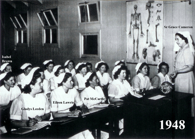
Nurse Classroom, 1948, Ballarat Base Hospital
Nurses Lecture Room c.1948, Ballarat Base Hospital. In the former children's ward, a tutor sister instructs trainees on the intricacies of the human skeleton. Their Examination papers might require an account of the structure of a joint, or of the nursing of fractures treated in 'skeletal traction'. Back Row L-R: Isabelle Brown, Mabele Rogers, Pat Lemon, Enid Murphy Front Row L-R: Gladys Leeden, Eileen Lawrie, Pat McCarthy ?, ?, ?, (maybe Joan Kube, Rita Lloyd, ?) Student nurses with tutor Sister Grace CameronPhoto - black & whitecameron, tutor, student, classroom -
 Melton City Libraries
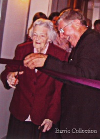
Photograph, Edna Barrie, Unknown
Over 20 years commencing in the 1970s, Edna undertook extensive photographing of the changing streetscape of Melton’s High Street. She anticipated the impact of change on the community during the time of Melton’s rapid transition from a small farming district to a large urban community and this led to her extensively document and photograph many of the structures and landscape features of the township that have since been lost. She also meticulously recorded much of the contemporary life of the town and has left a significant legacy of archival material. Edna Barrie cutting a ribbon to an opening of a eventlocal identities, pioneer families -
 Melbourne Tram Museum
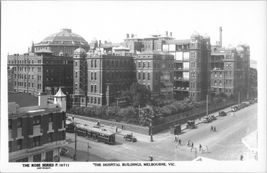
Postcard, Rose Stereograph Co, "The Hospital buildings, Melbourne Vic", c1930
Rose Series postcard No. P 10711, titled "The Hospital buildings, Melbourne Vic" with W class 232 southbound in Swanston Street at Lonsdale Street. This tram was converted to a W2 class during Jan. 1932. Has another tram behind it. The Melbourne Hospital is in the background and nurses and patients can be seen on the balconies. There is one horse drawn cab parked in Lonsdale Street near the cast iron urinal structure along with a fruit vendor's carts by the hotel entry. In the background is the Britannia Hotel.Yields information Swanston St and the Melbourne Hospital c1930.Postcard - printed real photograph with Rose Stereograph Co. name on the rear. Two copies held.On rear of 2nd copy "Greetings from Katie Williams"tramways, trams, lonsdale st, hospital, w class, tram 232, swanston st -
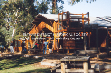 Eltham District Historical Society Inc
Slide - Photograph, Adventure Playground, Wattletree Road, Eltham North, c.Nov. 2001
Part of a slide show presentation "A Trip Down the Diamond Creek" by Russell Yeoman to the Eltham District Historical Society meeting of 14 Nov. 2001 A community group project steered by Bambi McLean led to the construction of the Eltham North Adventure Playground which opened off Wattletree Road in 1995. The structure was mainly wooden and included an undercover element with slides and areas to climb. It was destroyed by fire in the early hours of 16 December 2017. A new adventure playground was built in 2018. 35mm colour positive transparency Mount - Black and Whiteadventure playground, eltham north, wattletree road -
 Bendigo Military Museum
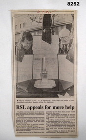
Article - MONUMENT FUND RAISING, 10.7.1992
The article covers the Bendigo RSL's efforts to have a Memorial Monument erected to Honor Ex Servicemen and Women in Campaigns WW2 onwards. It would be a 3.5 Metre Granite structure. $16,000 had been raised at this point, another $4,000 was needed. It would be placed in front of the Soldiers Memorial Institute Building in Pall Mall Bendigo. Ernie Jackman was the Bendigo RSL Appeals Officer and Chairman of the Memorial Committee. Refer Cat No 8133.2P for his RSL work. Refer Cat No 8245.2Article from a newspaper, all black print, photo at the top showing a boy and a man looking over a model of a monument followed by the article.On the top in red ink, "10.7.1992"brsl, smirsl, article, monument -
Glen Eira Historical Society
Document - History of the City of Caulfield
This file contains 4 items: 1/Typewritten document titled ‘The City of Caulfield’. Author and date unknown. 1 page (back and front), 2 copies. Document covers topics such as origins of the name ‘Caulfield’, early settlement and the Caulfield Cup. 2/Typewritten document titled ‘History of Caulfield Council’. Author and date unknown. 6 pages, 3 copies. Document covers subjects such as early settlement, Aboriginal influence, Caulfield Road Board, Shire of Caulfield, Borough and town boundaries, coat of arms, and Freedom of Entry to the City. 3/Typewritten document (undated + author unknown) titled ‘The Structure of Local Government in Victoria with a history of the City of Caulfield’. 13 pages. Covers the following subjects: Powers, Planning, Public Works, Trading Undertakings, Health Services, Municipalities, Wards Electors or Ratepayers, Voters Roll, Councillors, Officers, Finance, Nature of Soil and Vegetation, Parks and Gardens and Reserves, Coat of Arms, Boundaries, How Did Caulfield get its Name, Aboriginal Influence, Caulfield Road Board, Shire of Caulfield, Borough and Town and the City of Caulfield. Also covered is early settlement. Note at the end of the document mentions that the historical content contained in the last section was based upon a thesis for the Department of Town and Regional Planning, University of Melbourne, 1968 by L. Alwis, P. Rowe, N. Wootten. Melbourne, ‘City of Caulfield: An Illustrated City Report’. 4/Typewritten document (undated) titled ‘The Structure of Local Government in Victoria with notes on the history of the City of Caulfield’. 8 pages, 2 copies. This document also includes a map/diagram of the city with boundaries and wards showing locations of railway stations and parks. Document covers the structure of local government and its functions then goes on to focus on City of Caulfield with subjects similar to those covered in item 3. Document signed off by Deputy Town Clerk.city of caulfield, caulfield john, caulfield baron, caulfield racecourse, elsternwick, ripponlea, st. mary’s church, caulfield council, kooyong road, neerim road, bambra road, greenmeadows house, caulfield park, paddy’s swamp, dandenong road, caulfield grammar school, chisholm institute of technology, murrumbeena, glen eira road, alma road, orrong road, balaclava road, inkerman road, ‘grosmont’, caulfield school room, caulfield road board, caulfield road district, crimean war, victorian amateur turf club, caulfield cup, glenhuntly road, north road, glenhuntly station, ormond station, outer circle railway, local government, gardenvale, carnegie, rosstown, poath road, nepean highway, hotham street, ormond park, princes park, ross william murray, caulfield institute of technology, ‘ross’ folly’, hawthorn road, glenhuntly, ormond, morris t. w., lloyd charles du plan, meals on wheels, shire of caulfield, caulfield railway station, caulfield rsl, bouran road, murrum murrumbeen, kooyong road, great dandenong road, neerim road, trams, prahran and malvern tramways trust, fisher andrew, mackinnon reserve, dover street, ‘glen eira’, blair max cr., insignia, third ordnance services unit, schools, street lighting, lampriere, mr. bevan, the caulfield leader, davies j. henry, curraweena road, st. georges road, o’neill college, hope george, market gardens, koornang reserve, packer reserve, murrumbeena reserve, hopetoun gardens, greenmeadows gardens, mirambeena, caulfield technical college, hart john, langdon h. j., ‘rosecraddock’, judge webb, ‘crotonhurst’, service james, ‘kilwinning’, ricketson henry, grimwade frederick sheppard, airdrie, jenner, st. aubin’s, caulfield john p. t., harlston, lempriere, lord reserve, ‘cantala’ -
 Orbost & District Historical Society
black and white photographs, Howard D. Bulmer, first half 20th century
This bridge was built in the 1920s as a road and rail bridge, and was partly washed away by flood waters in 1934. After the end of the first World War the Victorian Railways considered an extension of the railhead across the river at Orbost, and in 1922 a new timber and steel girder structure, a joint Country Roads Board — Victorian Railways venture, was built and completed at a cost of £41,000 (the steel girders came from the Flinders Street viaduct reconstruction). Subsequently it was decided not to take the railway across the river, and the bridge has only been used by road traffic. This is a pictorial record of an early bridge across the Snowy River at Orbost.A large black / white photograph of the Orbost Snowy River bridge. There is a large copy as well as a postcard copy in sepia.on front - Snowy River Bridge Orbost H.D. Bulmer - photo - Lake Tyers.snowy-river-bridge-orbost -
 Warrnambool and District Historical Society Inc.
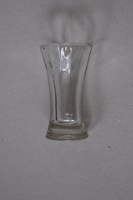
Criterion Hotel Glass, Glass, Mid 20th century
This small glass has been kept as a souvenir of the Warrnambool Criterion Hotel by a local resident, James Godfrey. The Criterion Hotel opened in Kepler Street, Warrnambool in April 1872. The first licensee was John Tate and the Humm family members of Woodford and the McGennan family of Warrnambool were prominent licensees and owners in the late 19th and 20th centuries. In the second half of the 20th century the hotel was an important centre in Warrnambool for live pop music. The hotel closed in 2008. The building was partially destroyed by fire in 2010 and the remaining structure was demolished in 2013. This glass is significant because it has local provenance as a memento of a hotel in Warrnambool prominent in the local business world for 136 years and as an example of the souvenirs kept of this hotel by Warrnambool residents.This is a small clear glass tumbler with a heavy base and a slightly tapered neck and a circular open top. The name ‘Criterion Hotel’ has been etched on to the side of the glass.Criterion Hotelcriterion hotel warrnambool, history of warrnambool, glass -
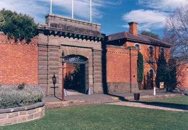
 Federation University Historical Collection
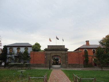
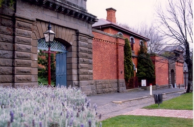
Photograph - Colour photograph, Former Ballarat Gaol Gates, 24/04/2017
The main gate to the former Gaol is a monumental work. The arch keystone facing Lydiard Street is beautifully executed. The gates and the iron lacework over the top are distinctive.The arch under the flyover is also distinctive; the basalt keystone appears to have been cut from one single block of stone. Most of the gaol has been demolished to allow the School of Mines Ballarat to expand onto the site. The remaining structures at the site include the main gate, warden's residence and governor's residence. These buildings are now used by Federation University.The main gate to the former Gaol is a monumental work. The arch keystone facing Lydiard Street is beautifully executed. The gates and the iron lacework over the top are distinctive.The arch under the flyover is also distinctive; the basalt keystone appears to have been cut from one single block of stone. gate, gaol, arch keystone, lydiard street, iron lacework, flyover, stone, basalt, warden's residence, governor's residence, ballarat school of mines, federation university, former ballarat gaol -
 Halls Gap & Grampians Historical Society
Photograph - B/W, C 1920s
The Stoney Creek dray bridge. Stoney Creek has been bridged a number of times on school road since the creek was re-routed in the early 1900s. A dray bridge was built C 1910 by local residents, which stood them in good stead for more than a decade. This bridge was replaced by a higher timber structure. Image two is a story from 1906 relating to Marshall White and his family trying to recross Delley's bridge after finding the Stoney Creek dray bridge washed away.Photo of two men on horseback on a wooden bridge with low log railing. A shelter can be seen in the background and there are thick trees surrounding the road.structures, bridges -
 Kiewa Valley Historical Society
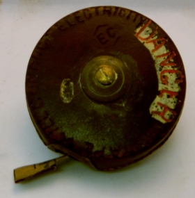
Tape Measure 33ft, Early to mid 1900's
This flexible measuring tape was used by the SEC Victoria in the mid to late 1900's. It was in a period before digital measuring instruments were in use. This is a 33ft long tape measure and would have been used by the construction workers when building the Kiewa Valley Hydro System. The warning details (embossed into the leather covering) was to warn users to be careful not to use the tape near live electricity terminals or linkages. This tape was produced mainly for wooden structures and not electricity conductive material. This was during the 1950's to 1960's.This imperial tape measure is very significant to the Kiewa Valley as it was used in the construction of the Kiewa Valley Hydro Scheme of the 1950's-1960's. It provides evidence that small measuring equipment used in the construction and the continuing maintenance of the scheme was of the imperial measure and used by construction workers who remained and settled in the town of Mount Beauty and Kiewa Valley long after the construction period. This flexible metallic measuring tape (33 ft in length) is contained in a round circular leather bound container. It has brass fittings (winder and tape guide) and is stitched with heavy grade twine. The tape measure is graduated in feet and inches on one side and yards on the other. Embossed in the leather casing"MADE IN ENGLAND" and around the inner circle "HOCKLEY ABBEY" and "JOHN RABONE & SONS"imperial tape measure, distance measures, imperial tools -
 Eltham District Historical Society Inc
Photograph, Sugarloaf Reservoir, Christmas Hills, 16 January 2015, 16 January 2015
Structure at Sugarloaf. Sugarloaf Reservoir is situated on former farmland. This large water storage was completed in 1982 and serves Melbourne's northern suburbs. Within the visitor areas are two picnic grounds and other recreational facilities. Below its massive rock embankment is located the Winnecke Treatment Plan designed to purify its water before being piped into Melbourne. The dam partly inundated the old firing ranges of the former Christmas Hills Rifle Club. Source: Christmas Hills Now and then: Yarra Glen & District Historical Society, 2004. Born Digitalchristmas hills, sugarloaf reservoir -
 Federation University Historical Collection
Photograph - Photograph - Colour, Former Ballarat Gaol Gates and Warden's Quarters, 2001, 1991
The Ballarat Gaol operated between 1862 and 1965. The complex was based on a central hall from which radiated wings of cells. This meant one guard could stand in the centre of the hall and see all the cells. Most of the gaol was demolished to allow the School of MInes Ballarat to expand. The remaining structures at the site include the main gate, the Warden's Residence, shown in the photo, and the Governor's Residence. These buildings are now used by Federation University. The Warden's Residence is home to the Australian Centre for Research into Injury in Sports and its Prevention.Colour photograph of the main gate of the former Ballarat Gaol and the Warden's Quarters. The gate features a beautifully executed arch keystone of basalt and appears to be cut from one single block of stone. The two storey Warden's Quarters are to the right of the gates.ballarat gaol, lydiard street south, ballarat school of mines, cells, guard, warden's residence, governor's residence, federation university -
 Federation University Historical Collection
Colour photograph, Ballarat Courier Photographer, Former Ballarat Gaol Gates, 09-06-1997
The main gate to the former Gaol is a monumental work. The arch keystone facing Lydiard Street is beautifully executed. The gates and the iron lacework over the top are distinctive.The arch under the flyover is also distinctive; the basalt keystone appears to have been cut from one single block of stone. Most of the gaol has been demolished to allow the School of Mines Ballarat to expand onto the site. The remaining structures at the site include the main gate, warden's residence and governor's residence. These buildings are now used by Federation University.The main gate to the former Gaol is a monumental work. The arch keystone facing Lydiard Street is beautifully executed. The gates and the iron lacework over the top are distinctive.The arch under the flyover is also distinctive; the basalt keystone appears to have been cut from one single block of stone. gate, gaol, arch keystone, lydiard street, iron lacework, flyover, stone, basalt, ballarat school of minesfederation university, warden's residence, governor's residence -
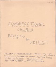 Bendigo Historical Society Inc.
Document - Lydia Chancellor collection: congregational church Bendigo and district
The Sutton grange Congregational Church was built in 1865. Original services were held in the home of Mr James Grey who served the church for 50 years. The Bendigo Congregational church originally operated out of the Mechanics Institue building before moving temporarily to the Church of England school room. In May 1858, a meeting was held to establish a permanent building and tenders were called in September 1858. Land was purchased in Forest Street from the estate of Mr WIlkinson and the new brick structure was opened 28/11/1858.Manilla folder titled: Congregational Church Bendigo and district. Centenary of congregationalism in Bendigo 1859 to 1959, 14-15 March 1959. Centenary of congregational church and state school at Sutton Grange, 27-28 March 1965. Also, press reports in the Bendigo Advertiser.sutton grange, congregational church, centenary -
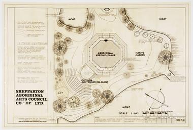 RMIT Design Archives
Work on paper - Architectural drawings, Aboriginal Keeping Place, Shepparton International Village
Site plan drawing of the Shepparton Aboriginal Arts Council building, now known as the Bangerang Cultural Centre. The building is located in the Parkside Gardens, formerly the Shepparton International Village, and is the first Aboriginal cultural museum developed and managed by the Aboriginal community. The building is part of the Victorian Heritage Register. Romberg designed the building in conjunction with project instigator and Bangerang Elder, John Sandy Atkinson, OAM. At the request of Romberg, Atkinson created some concept sketches for the building from which Romberg designed the finished structure.Site PlanInitialed in grey pencil, bottom right: 'F.R'architecture, museum