Showing 2428 items matching "1861-1865"
-
 Kiewa Valley Historical Society
Papers - Havilah Cemetery, Havilah Cemetery Formerly Running Creek Cemetery
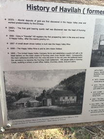
In 1889, 24 residents of the Running Creek and surrounding district submitted a petition to the Minister of Lands, Melbourne requesting land for a cemetery. Their request was granted. The Cemetery was decommissioned in the early 1950s and the last trustee for the cemetery died in 1986. There is a wooden fence around the boundary (May 2024). One paper lists 29 names in the Burial Register 1861-1948. The last two sheets record the history as a timeline from the 1850s to the 1900s. Havilah was a gold mining settlement from the 1850s located 20km west of the Kiewa Valley and in the Ovens catchment near Myrtleford.Five black and white A4 pages stapled together. Copies of the sign erected at the gate of 'Havilah cemetery formerly Running Creek Cemetery'. Also the 'History of Havilah formerly Running Creek'havilah, running creek, cemetery -
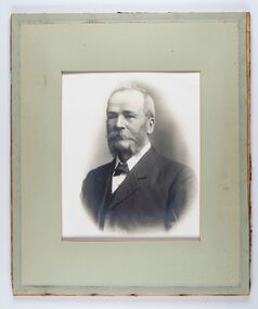
 City of Greater Bendigo - Civic Collection
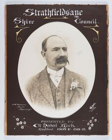
Photograph - Portrait of Councillor Keck, W H Robinson, c 1913
The district of Strathfieldsaye was proclaimed in 1861 and named a Shire on the 17th September in 1866. It remained a shire until amalgamation in 1994 when it became part of the City of Greater Bendigo. The shire was located 8 km to the south- east of Bendigo and covered an area of 601 square kilometres and extended from the Calder Highway to the Coliban and Campaspe Rivers. The shire's administration centre was in Strathfieldsaye until 1972 when new offices were opened in Kennington.Framed black and white head and shoulder portrait of Councillor Keck with hand coloured and drawn detail. Profile slightly to right with walrus moustache. Cut oval brown mount decorated with text and flowers. Hand written title top and lower centre.Strathfieldsaye / Shire Council / W.H. Robinson / Photo / Bendigo / J.H.E Gribbs / Presented by / Cr Herbert Keck / President 1903-4. 1912-13.shire of strathfieldsaye, councillor keck, strathfieldsaye shire council, president of strathfieldsaye shire -
 City of Greater Bendigo - Civic Collection
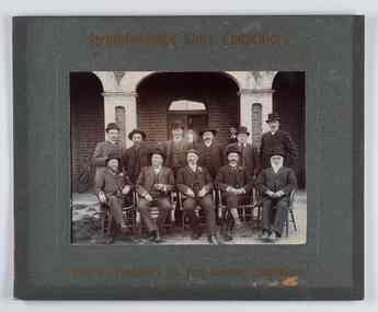
Photograph - Councillor group portrait, W H Robinson, Strathfieldsaye Shire Council, 1909
The district of Strathfieldsaye was proclaimed in 1861 and named a Shire on the 17th September in 1866. It remained a shire until amalgamation in 1994 when it became part of the City of Greater Bendigo. The shire was located 8 km to the south- east of Bendigo and covered an area of 601 square kilometres and extended from the Calder Highway to the Coliban and Campaspe Rivers. The shire's administration centre was in Strathfieldsaye until 1972 when new offices were opened in Kennington.Photographic group portrait of eleven Strathfieldsaye Shire Councillors in front of the Strathfieldsaye Shire Hall. Five men are seated and six standing with one man standing further in back ground on the building's verandah. Photograph is attached directly to green mount card and framed. Gold lettering on mount.Strathfieldsaye Shire Councillors / R. B. Brennan (Sec.) W. J. Lowdes S. Doak M. Burns () N Condon B. Code (Inspector) / WH Robinson Photo Bendigo / T Somerville / W. I. Long / Fred Osborne (President) H Keck / W Dresler / With the President's (Cr. Fred Osborne) Compliments / September 23rd, 1909shire of strathfieldsaye, strathfieldsaye shire council, president of strathfieldsaye shire, strathfieldsaye shire hall -
 City of Greater Bendigo - Civic Collection
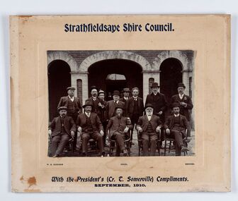
Photograph - Councillor group portrait, W H Robinson, Strathfieldsaye Shire Council
The district of Strathfieldsaye was proclaimed in 1861 and named a Shire on the 17th September in 1866. It remained a shire until amalgamation in 1994 when it became part of the City of Greater Bendigo. The shire was located 8 km to the south- east of Bendigo and covered an area of 601 square kilometres and extended from the Calder Highway to the Coliban and Campaspe Rivers. The shire's administration centre was in Strathfieldsaye until 1972 when new offices were opened in Kennington. Group portrait of 13 men / councilors, 5 seated and 8 standing dressed in suits. There are another 2 men further back in front of the hall doors. Photograph is taken outside the Strathfieldsaye Shire Hall.Srathfieldsaye Shire Council. / With the President's (Cr T. Somerville) Compliments. / September, 1910 / W.H. Robinson Photo. Bendigo Verso; William Drechslershire of strathfieldsaye, president of strathfieldsaye shire, strathfieldsaye shire council -
 City of Greater Bendigo - Civic Collection
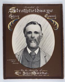
Photograph - Portrait of Councillor Burke
The district of Strathfieldsaye was proclaimed in 1861 and named a Shire on the 17th September in 1866. It remained a shire until amalgamation in 1994 when it became part of the City of Greater Bendigo. The shire was located 8 km to the south- east of Bendigo and covered an area of 601 square kilometres and extended from the Calder Highway to the Coliban and Campaspe Rivers. The shire's administration centre was in Strathfieldsaye until 1972 when new offices were opened in Kennington. Framed black and white head and shoulder portrait of Councillor Burke with hand coloured and drawn detail. Profile centre facing with beard. Cut oval brown mount decorated with text and fscrolls. Hand written title top and lower centre. Wooden frame with detail and gold inner.Presented to Strathfieldsaye / shire Council / w. H. robinson / Photo / Bendigo / By the family of / Cr John Burke / President 1890 - 1899 - 1900strathfieldsaye shire council, councillor burke, president of strathfieldsaye shire -
 City of Greater Bendigo - Civic Collection
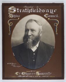
Photograph - Portrait of Councillor Thomas Somerville, W H Robinson
The district of Strathfieldsaye was proclaimed in 1861 and named a Shire on the 17th September in 1866. It remained a shire until amalgamation in 1994 when it became part of the City of Greater Bendigo. The shire was located 8 km to the south- east of Bendigo and covered an area of 601 square kilometres and extended from the Calder Highway to the Coliban and Campaspe Rivers. The shire's administration centre was in Strathfieldsaye until 1972 when new offices were opened in KenningtonFramed black and white head and shoulder portrait of Councillor Somerville with hand drawn detail. Profile slightly to left, face has full beard. Cut oval brown mount decorated with text and scrolls. Hand written title top and lower centre.Presented to / Strathfieldsaye / Shire Council / W. H. Robinson / Photo / Bendigo / by / Cr Thomas Somerville / President 1892 - 3. 1901.2. 1910.11 strathfieldsaye shire council, councillor somerville, president of strathfieldsaye shire -
 City of Greater Bendigo - Civic Collection
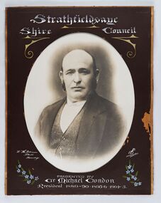
Photograph - Portrait of Councillor Michael Condon, W H Robinson
The district of Strathfieldsaye was proclaimed in 1861 and named a Shire on the 17th September in 1866. It remained a shire until amalgamation in 1994 when it became part of the City of Greater Bendigo. The shire was located 8 km to the south- east of Bendigo and covered an area of 601 square kilometres and extended from the Calder Highway to the Coliban and Campaspe Rivers. The shire's administration centre was in Strathfieldsaye until 1972 when new offices were opened in KenningtonFramed black and white head and shoulder portrait of Councillor Condon with hand coloured and drawn detail. Profile slightly to left. No facial hair. Cut oval brown mount decorated with text, scrolls and flowers. Hand written title top and lower centre.Strathfieldsaye / Shire / Council / W. H. Robinson / Photo / Bendigo / JMB Gribble / Presented by / Cr Michael Condon / President 1889 - 90. 1895-6. 1904 - 5strathfieldsaye shire council, president of strathfieldsaye shire, councillor condon -
 City of Greater Bendigo - Civic Collection
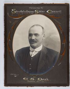
Photograph - Portrait of Councillor Doak, W H Robinson
The district of Strathfieldsaye was proclaimed in 1861 and named a Shire on the 17th September in 1866. It remained a shire until amalgamation in 1994 when it became part of the City of Greater Bendigo. The shire was located 8 km to the south- east of Bendigo and covered an area of 601 square kilometres and extended from the Calder Highway to the Coliban and Campaspe Rivers. The shire's administration centre was in Strathfieldsaye until 1972 when new offices were opened in Kennington.Framed black and white head and shoulder portrait of Councillor Doak with hand coloured and drawn detail. Left facing profile with walrus moustache. Cut oval brown mount decorated with text and scrolls. Hand written title top and lower centre.Presented to / Strathfieldsaye Shire Council / W. H. Robinson / Photo / JMB Gribble / by Cr S. Doak / President 1911 - 1912strathfieldsaye shire council, president of strathfieldsaye shire, councillor doak -
 City of Greater Bendigo - Civic Collection
Photograph - Portrait of Councillor Long, Talma & Co
The district of Strathfieldsaye was proclaimed in 1861 and named a Shire on the 17th September in 1866. It remained a shire until amalgamation in 1994 when it became part of the City of Greater Bendigo. The shire was located 8 km to the south- east of Bendigo and covered an area of 601 square kilometres and extended from the Calder Highway to the Coliban and Campaspe Rivers. The shire's administration centre was in Strathfieldsaye until 1972 when new offices were opened in Kennington.Framed black and white head and shoulder portrait of Councillor Long. Profile to left with walrus moustache and mutton chops. Cut olive retangle mount. Verso; Long. On under board which has photograph attached; Talma & Co. / 119 Swanston St., / Melbournestrathfieldsaye shire council, councillor long -
 City of Greater Bendigo - Civic Collection
Photograph - Portrait of Councillor Hargraves, Bartlett Bros
The district of Strathfieldsaye was proclaimed in 1861 and named a Shire on the 17th September in 1866. It remained a shire until amalgamation in 1994 when it became part of the City of Greater Bendigo. The shire was located 8 km to the south- east of Bendigo and covered an area of 601 square kilometres and extended from the Calder Highway to the Coliban and Campaspe Rivers. The shire's administration centre was in Strathfieldsaye until 1972 when new offices were opened in KenningtonFramed black and white head and shoulder portrait of Councillor Hargraves. Profile slightly to right with walrus moustache. Cut rectangle brown mount decorated with coloured text and scrolls. Hand written title top and lower centre.Strathfiledsaye Shire Council / Cr John Hargreaves / President 1919 - 20 1928 - 29 / Presented by his Wife & Familystrathfieldsaye shire council, president of strathfieldsaye shire, councillor hargreaves -
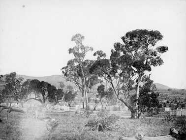 Stawell Historical Society Inc
Photograph, Pleasant Creek Cemetery 1866
Pleasant Creek Cemetery. Part of a collection of Photographs by Mr. O.G. Armstrong as commissioned by the Shire of Stawell for the Inter-colonial and Paris Exhibition in Melbourne in 1866. The site of the Pleasant Creek Cemetery was proclaimed on October the 14th, 1861. Prior to that, a cemetery existed on ‘One Tree Hill’ where burials were made as early as 1854. A memorial is located on the site of the One Tree Hill Cemetery, corner of Griffith and Leslie streets, Stawell West. stawell -
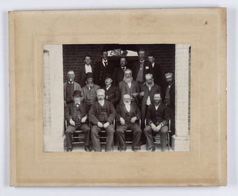 City of Greater Bendigo - Civic Collection
Photograph - Strathfieldsaye Councillor Group Portrait, D.G. Coope & Son - Framers
The district of Strathfieldsaye was proclaimed in 1861 and named a Shire on the 17th September in 1866. It remained a shire until amalgamation in 1994 when it became part of the City of Greater Bendigo. The shire was located 8 km to the south- east of Bendigo and covered an area of 601 square kilometres and extended from the Calder Highway to the Coliban and Campaspe Rivers. The shire's administration centre was in Strathfieldsaye until 1972 when new offices were opened in Kennington.Silver gelatin framed photographic group portrait of fifteen men taken in the alcove of the Strathfieldsaye Shire Hall. Four men are seated and eleven are standing. Photograph is attached directly to cream mount card. Handwritten note with photograph: 1/ John Burke, 2/ (?), 3/ (?), 4/ RHS Abbott, 5/ M Brennan, 6/(?) 7/(?) 1/. M Condon? 2/ (?) 3/ M Burns, 4/(?) Gentlemen at back are probably council staff.shire of strathfieldsaye, strathfieldsaye shire council, president of strathfieldsaye shire, councillor john burke, councillor r.h.s. abbott, councillor brennan, councillor condon, councillor m burns -
 Linton and District Historical Society Inc
Conveyance document, Conveyance document, 1863 : sale of Allotment 15, Section 1, Township of Linton : Henry Franks to William Hugill
The land (with improvements) was sold for £650. Henry Franks had purchased the land for £16.15s at the Sale of Special Lands at Linton in 1861. The land, on the corner of Sussex and Clyde Streets, Linton, was later owned by David McFadzean, and after his death by several generations of the Barr/Greenbank families. It is understood that David McFadzean built the house there in 1873. (House still standing, generally referred to as "Barr's" - current address 64 Sussex Street, Linton.)A3 photocopy of an agreement ("indenture") made in 1863 between Henry Franks and William Hugill for the sale/purchase of Allotment 15, Section 1, Township of Linton. henry franks, william hugill, conveyance documents, land sales, land purchases, j. h. barr, david mcfadzean, allotment 15 section 1 township of linton, 64 sussex street linton -
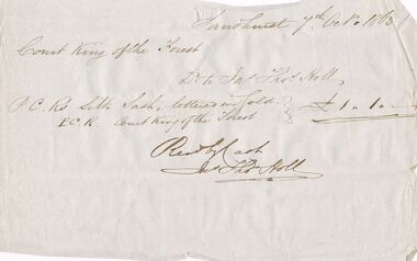 Bendigo Historical Society Inc.
Document - ANCIENT ORDER OF FORESTERS NO. 3770 COLLECTION: NOTE
'Bendigo Advertiser, Monday 18th May 1863, p2: ' On the occasion of the first anniversary of Court Sherwood of the Ancient Order of Foresters, a ball was given by the members at the Sir Henry Barkly Hotel, Huntly on Thursday night last. There must have been at least 70 or 80 persons present, many of them from Sandhurst, White Hills, Eaglehawk and etc. Dancing commenced at nine o'clock and was vigorously kept up till the early dawn of another day came to light. Supper was served in the Court Room and the excellent repast provided by the host was duly appreciated .... from casual observation appearances would indicate that on a future day the Foresters would create a Court into which the ladies would be permitted to join in the bonds of fellowship.' Bendigo Advertiser, Thursday 2nd November 1865, p 2: 'The fourth anniversary of the establishment of Court Bendigo of the above order was celebrated on Tuesday evening at the Bendigo Hotel by a supper. There were between forty and fifty members present. The Secretary, in the course of his remarks, referred to the progress which the court had made since its establishment in October 1861. He stated that the court opened with 35 members and now numbered about 200. He congratulated the Court on having more members than any other court of the order in the district. Since it was established there had only occurred one death and at present there was only one sick member declared as receiving aid from the funds. District Secretary Holl, in responding to the toast of prosperity at the Bendigo United District of the Ancient Order of Foresters, stated that the district was first formed in 1862. At the end of the first quarter of 1862, there were eight Courts numbering 479 members. At the end of the last quarter there were twelve Courts, numbering 1278 financial members. The funds of the district in July 1862 amounted to £22/2/2d and in October 1865, the amount had increased to £570/2/8d while the Court funds amounted to £3,330/18/9d. During the last twelve months £893/8/10d had been paid for the benefit of the sick, thus showing the great benefits which were derived by becoming members of the order. Note dated 7 Oct. 1863, Court King of the Forest for P. C. R. Silk Sash £1/1/-. Signed by Jas. Thos. Holl.societies, correspondence, ancient order of foresters no. 3770 collection - note, court king of the forest, jas thos holl -
 Bendigo Historical Society Inc.
Document - SEDGWICK INFORMATION
Document, Sedgwick, was known as Upper Emu Creek until 1901. It is located ten miles south of Bendigo in hilly sedimentary and granite country.The first freehold grants were taken up in 1854. In 1861 the Strathfieldsaye Road District was Proclaimed. Five years later it became the Shire of Strayhfieldsaye.Mining west of the Axe Creek commenced in 1863. Agriculture, farmers made modest livings from vineyards, orchards,dairy cattle, eggs and tomatoes. The Osborne family had seventy acres planted to apples. Prior to 1934 Favaloros collected cream from district farms, then fresh milk in cans was carted to Bendigo until 1970.document, sedgwick -
 Bendigo Historical Society Inc.
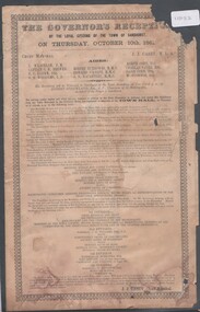
Pamphlet - Agenda for The Govenor's reception by the loyal citizens of the Town of Sandhurst on Thursday 10th October 1861, 25/02/2025
Victorian Govenor's visit to Sandhurst (Bendigo)Agenda for The Govenor's reception by the loyal citizens of the Town of Sandhurst on Thursday 10th October 1861 On the procession appearing in view from the centre of the town, a salute of 13 guns will be fired from the Camp Reserve. Marching along High Street and Pall Mall, to Bull Street, to Hargreaves Street, down Hargreaves Street to Mundy Street and up to the Criterion Hotel, the procession will halt in front of the hotel when his Excellency, as he alights from the carriage, will receive a military salute from the Volunteers, under Captain Anderson. The procession will then proceed up Mundy Street, and along Hargreaves Street, and along Lyttleton Terrace and dissolve in the Market reserve.vice-regal visits -
 Bendigo Historical Society Inc.
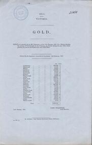
Document - MINING REPORTS - GOLD PER ESCORT TAKEN TO TREASURY VICTORIA 1860-1
Gold Return showing the amount of Gold brought to the Treasury, per Escort, during the year 1860, from each gold office. Printed on pale blue paper and dated 11th January, 1861. Blue Royal Historical Society of Victoria Bendigo Branch stamp at the left top of page. Gold Offices mentioned are: Castlemaine, Blackwood, Maldon, Sandhurst, Heathcote, Rushworth, Kilmore, Maryborough, Avoca, Back Creek, Dunolly, Inglewood, Amherst, Ballaarat, Creswick, Fiery Creek, Ararat, Pleasant Creek, Smythesdale, Clunes, Beechworth, Buckland, Yackandandah, Indigo and Morse's Creek. Document is part of the Albert Richardson Collection. document, gold, mining reports, mining reports, gold returns victoria 1860-1, mr carpenter, john wilkinson, john ferres -
 Warrnambool and District Historical Society Inc.
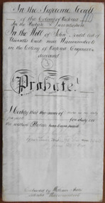
Document - John Gould Probate 1891, 1891
This 1891 document contains the information on the Will and Probate of John Gould, an engineer from Russells Creek. No information has been found on John Gould except that he died in October 1890 at the age of 67. The solicitor, William Ardlie was a well-known Warrnambool lawyer, commencing a practice in 1865 and continuing well into the 20th century making him at the time one of the longest-serving lawyers in the British Empire. Tait collection: item 10 of 62This document is of interest in that it includes information on a resident of Russells Creek in the Warrnambool area, and also the lawyer concerned is William Ardlie, one of the best-known identities in Warrnambool in the late 19th and early 20th centuries.This is an 1891 piece of parchment folded in half to give four pages of written material. This material is handwritten in black ink. A seal of the Supreme Court of the Colony of Victoria is attached with a green ribbon. The document is somewhat discoloured. ‘In the Supreme Court of the Colony of Victoria in the probate jurisdiction in the Will of John Gould, late of Russells Creek near Warrnambool in the Colony of Victoria, Engineer, deceased, Probate. I certify that there is no duty payable. J. F. Poole, Officer under Section 96, Act 1060, June 23rd 1891. Extracted by William Ardlie, Solicitor, Warrnambool’. john gould, william ardlie, warrnambool -
 Warrnambool and District Historical Society Inc.
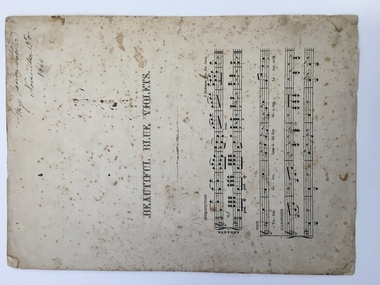
Leisure object - Sheet music, Beautiful blue violets, c. 1864
This piece of music was composed by Joseph Summers (1839-1917). The date of the composition is between 1863 and 1866. The brother of Charles Summers, the sculptor, Joseph Summers was born in England and came to Australia in 1865. He was an organist and composer, an Inspector of Music in schools and in charge of music examinations conducted through Trinity College, London. In 1897 he moved to Perth. The signature of ‘Miss Jessie Webster’ presents a problem as no information has been found on this person. This is a most significant item because of the date, 1866, and the name, ‘Jessie Webster’. But it is not known if the music has any local provenance. The item also has social significance as an example of the type of music played in mid-Victorian drawing rooms. This is a piece of music of four printed pages of musical notation. The cover of this music is missing. The paper is white with black printing and all the pages are much mottled and stained. The edges of the pages are ragged and torn. There is some pencil scribble on the first page. A name and a date are written in black ink on the first page. ‘Miys (Miss) Jessie Webster, November 13th 1866’jessie webster, joseph summers, warrnambool -
 Linton and District Historical Society Inc
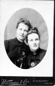
Photograph, Yeoman and Co 87 Elgin St, Carlton, Jane (Lily) and Mary (Millie)Blamire, daughters of William Blamire
Elizabeth Jane Blamire, b. 1865 and Rary Emelia Isabel Blamire, b. 1863, were two of the eight children of William Blamire and Mary Ann Blamire (née Green). The Blamire family lived at Linton, where William worked as a blacksmith and painter. In 1874 they purchased Allotment 8, Section 2, Township of Linton (now 48 Sussex Street, Linton) and built a house there which was their home for many years (now demolished).Oval sepia portrait of two young ladies dressed in high necked gowns."Jane Elizabeth Blamire (Lily)(left) Mary Isabel Blamire (Millie) (right) daughters of William Blamire of Linton (No) 1632"jane elizabeth (lily) blamire, mary isabel (millie) blamire -
 Linton and District Historical Society Inc
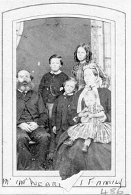
Photograph, Mr and Mrs Wearne and family
John Wearne migrated to Victoria from Cornwall in 1853. He was living in the Lintons/Smythesdale district by 1858, where he had mining interests. He married Ann McGie in 1865, after his first wife Selina Harris (married 1858) died in 1860. John and Ann Wearne had ten children, all born at Linton. Photograph is part of S E Surman collection (album) page 10 top right.Sepia photograph of a bearded gentleman wearing suit, seated with hands together on lap, two children standing behind, one child standing between he and a woman wearing long sleeved long outfit and hat, seated holding a young child wearing dress and shoes on her lap."Mr and Mrs Wearne and family". wearne family, surman collection, john wearne, ann wearne nee mcgie -
 Clunes Museum
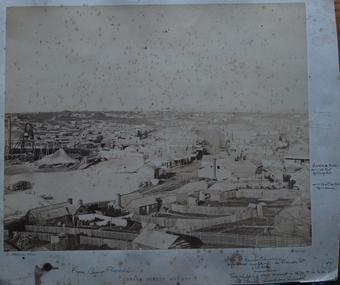
Photograph, C. NETTLETON, FRASER STREET, CLUNES, CIRCA 1866-67
PHOTOGRAPH OF FRASER STREET, FROM CAMP PARADE ABOUT 1866-67. NOTE STATE OF CREEK AND ABSENCE OF BRIDGES.PHOTOGRAPH OF FRASER STREET, CLUNES. TAKEN FROM CAMP PARADE .1 SEPIA PHOTOGRAPH MOUNTED ON CARDBOARD, .2 BLACK AND WHITE PHOTO PRINT .3 BLACK AND WHITE PHOTO PRINT MOUNTED ON CARDBOARD, TITLED CLUNES FROM CAMP PARADE - ABOUT 1865 .4 SEPIA PHOTOGRAPH MOUNTED ON BOARD WITH NOTES OF PLACES OF INTEREST AROUND PHOTO. TITLED FRASER STREET CLUNES. .5 BLACK ANBD WHITE PHOTO PRINT .6 SMALL PHOTO PRINT .7 SMALL PHOTO PRINT WITH DESCRIPTION ON BACK .8 SMALL PHOTO PRINT .9 SEPIA PHOTO PRINT .10 SEPIA PHOTO PRINTFRASER ST. CLUNESlocal history, photography, photographs, clunes township, early fraser street -
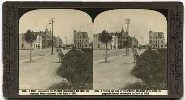 City of Moorabbin Historical Society (Operating the Box Cottage Museum)
Leisure object - The Rose Stereograph Cards, Coronation of King George V, 1911
This collection of Stereograph card depicts scenes from the Coronation of King George V. Produced by 'The Rose Stereographs. George Rose was born in Clunes, Victoria in 1861 and later worked in his father’s boot-making business in Prahran while studying photography. In 1880 he founded the Rose Stereograph Company and became famous for producing stereographs, or stereoviews, which gave the illusion of being in 3D when seen through a hand-held viewer. Some of the pioneers of Moorabbin were staunch supporters of the Monarchy of England. This collection of cards was donated by one of the founding pioneer families.Stereograph cards - 25 cards produced by Rose Stereographs. - black and whiteDescription of each card written on bottomcoronation, king george v, england, monarchy, moorabbin, london, westminster abbey, trafalgar square, boy scouts, crystal palace, queen mary -
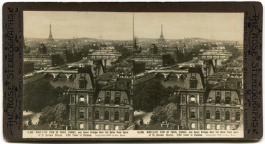 City of Moorabbin Historical Society (Operating the Box Cottage Museum)
The Rose Stereograph Cards, Various pictures of European sites, 1911
This collection of Stereograph card depicts scenes from various Euopean sites and buildings. Produced by 'The Rose Stereographs. George Rose was born in Clunes, Victoria in 1861 and later worked in his father’s boot-making business in Prahran while studying photography. In 1880 he founded the Rose Stereograph Company and became famous for producing stereographs, or stereoviews, which gave the illusion of being in 3D when seen through a hand-held viewer.Collection of one of the pioneer families of City of Moorabbin.11 Stereographic Cards - manufactured by The Rose Sterographics - Black and whiteDescription of each card on the bottomeurope, paris, church of mary magdalene, the louvre, cathedral of notre dame, palace of justice, palace of beautiful arts, champs elysees, boulevard du nord, jules anspach fountain, brussels belgium, cathedral of st gudule, brussels, moorabbin, stereograph cards -
 Uniting Church Archives - Synod of Victoria
Photograph, Undated c. 1891
Rev. John Thompson Field (1861 - 1938). Born at Geelong. Went to Papua as an unmarried Probationer. Ordained 1891. Served at: Dobu, Papua (1891), Tubetube (1893), Heywood (1901), Hamilton (1904), Camperdown (1907), Brighton (1909), Ubuia, Papua (1913), Dunolly & Tarnagulla (1914), Terang (1917), Williamstown (1920), Coburg & Moreland (1924), Devonport (1928), Supernumerary Hawthorn (1929). Married Frances Mary Harding (1857 - 1909) in Papua.Sepia toned head and shoulders studio portrait of the Rev. J. T. Field.rev john thompson field, methodist, minister, papua, frances mary harding -
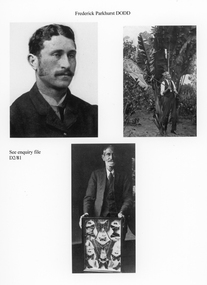 Stawell Historical Society Inc
Photograph, Mr Frederick Parkhurst Dodd -- 3 Photos
Three photographs of Frederick Parkhurst Dodd born 1861, in Wickliffe Victoria and the son of Frederick Willian Dodd and Maria Dodd nee Mayes. The photos were emailed to the society on 30.11.2011 showing Frederick P. Dodd as an Entomologist. Photo 1 shows Fredrick as a young man. Photo 2 as an older man with a large net on a long pole obviously netting insects. Photo 3 shows Frederick with a framed collection of large and small butterflies.Three small photo prints of Frederick Parkhurst Dodd as a young man and then at later stages of his life. stawell portrait -
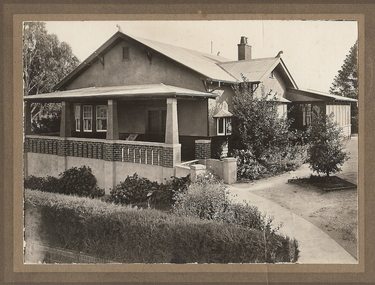 Bendigo Historical Society Inc.
Photograph - T C WATTS & SON COLLECTION: RODNEY STREET, BENDIGO, 1930
Frederick Steele Ferguson (1861-1938) married Beatrice O'Brien in 1898. Originally they lived at 19 Brodie Street, Quarry Hill, but by 1925 they were registered as living on the corner of Rodney and Reginald Street with their son Frederick Steele McNair Ferguson and his wife Amelia, and later with their daughter Maude. It appears the family continued to live at this address following Frederick snrs death. Frederick and his son Frederick jnr were wool merchants.Black and white photograph mounted on rectangular brown board. House, weatherboard and rough cast, verandah with brick balustrade and rough cast pillars, corrugated iron roof, 1 chimney with 2 pots, double front door, small bay window at RH side, bay window under verandah, sleepout/sunroom attached at back right, established garden, concrete path, hedge at front, woven crinkled wire fence. On back of photo' F. Ferguson, £1800 corner Rodney and Reginald Streets, 15.4.30 corner Rodney and Reginald Streets. 2012 photo of house attached to record.Frank A. Jeffree Bendigobendigo, business, t c watts & son -
 Uniting Church Archives - Synod of Victoria
Photograph, Rev and Mrs RM Hunter Wes Meths, Undated c.1869
Reverend Robert Morris Hunter was born in Scotland in 1839, married (1) Isabel McIntyre (1847-1890) in 1869 and (2) his deceased wife's sister Flora McIntyre in 1893. He died in Kooringa South Australia in 1894. He commenced his ministry in 1865 and served at Hamilton, Merino, Ballarat, Portland, Hamilton, Melbourne, Adelaide Archer Street, Moonta, Adelaide and Kooringa. He was President of Conference and President of Prince Alfred College in 1884.Sepia toned carte de visite studio portrait of the Rev. Robert Morris Hunter and his wife Isabel (nee McIntyre)."Revd RM Hunter No 10338"rev robert hunter, presicent of conference, prince alfred college, isabel mcintyre -
!['Reno', St John's Parade [Kew]](/media/collectors/550653872162f11fb04854aa/items/658d16120f23e8f1e738df53/item-media/658d16680f23e8f1e738e098/item-fit-380x285.jpg) Kew Historical Society Inc
Kew Historical Society IncPhotograph - 'Reno', St John's Parade [Kew], c. 1965
‘Reno’, stood on the east side of St John’s Parade. Its earliest recorded owner was the architect Samuel Cocking who lived there from c.1865 until his death in 1888. The original landholding was bordered by Cotham Road, Glenferrie Road, Wellington Street, and Charles Street. The garden including rare plants supplied by Baron Von Mueller, surrounds the cottage in a tangled frenzy. Despite a ‘local significance’ classification by the National Trust, the house was demolished in 1977.This work forms part of the collection assembled by the historian Dorothy Rogers (1905-1973), donated to the Kew Historical Society by her son in 2015. The manuscripts, photographs, maps, and documents were sourced by her from both family and local collections or produced as references for her print publications. Many were directly used by Rogers in writing ‘Lovely Old Homes of Kew’ (1961) and 'A History of Kew' (1973), or the numerous articles on local history that she produced for suburban newspapers. Most of the photographs in the collection include detailed annotations in her hand. The Rogers Collection provides a comprehensive insight into the working habits of a historian from the 1960s to the 1970s. Original monochrome photograph of Reno, St John's Parade, Kew. Pictured are the garage in the distance at left, the weatherboard house with its simple verandah, and the overgrown front garden.Annotation verso: "Reno. St Johns Parade. Reno. Miss Green".dorothy rogers, reno.-- st john's parade (kew) -
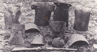 The Beechworth Burke Museum
Postcard
These pieces of Kelly Gang armour (including pieces manufactured by police) were photographed outside Beechworth Court House during committal proceedings in 1880. Ned Kelly, born in June 1855, was one of the last Australian bushrangers. An outlaw, gang leader and convicted police killer, Ned Kelly's distinctive armour has become entrenched in Australian lore. Ned's younger brother Dan Kelly (born in 1861), wore similar armour to his older brother. Black and white rectangular postcard printed on paper cardObverse: NED AND DAN KELLY'S ARMOUR TAKEN DURING HIS TRIAL AT BEECHWORTH IN 1880 Reverse: POSTCARD / CORRESPONDENCE / ADDRESS ONLY KODAKkelly album, bushranger, ned kelly, dan kelly, daniel kelly, kelly gang, armour, kelly trials