Showing 32414 items
matching buildings/streetscapes
-
 Eltham District Historical Society Inc
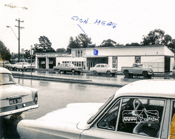
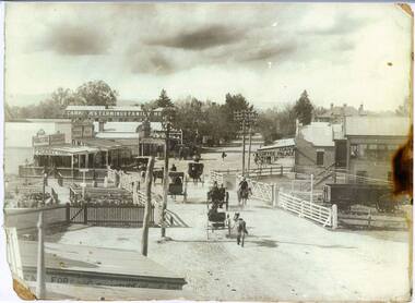
Photograph, Bryant Motors, Eltham, 1960c
Black and white photograph of Bryant Motors and Bus Depot, Main Road, Eltham opposite Luck Street, c.1960.Rough drawing of building with dimensionsbryant motors, main road, eltham, bus depot -
 Tatura Irrigation & Wartime Camps Museum
Photograph, Clark D, 1989
49 Hogan street Tatura, office of W. S. Murray, engineer, surveyor. Water Trust office, Dr's residence, J. Reilly's residence. Present Museum.Black and white photograph of 6 men and surveying equipment outside 49 Hogan street Tatura.on building - Walter Scott Murraywalter scott murray, water trust, museum -
 Wodonga & District Historical Society Inc
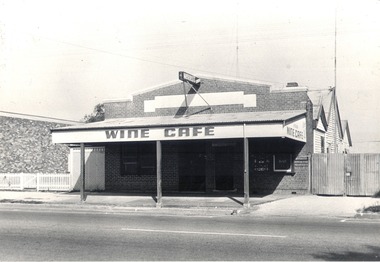
Slide - Mann Collection Album - High Street West from Lawrence Street - old Wine Café, C. 1940s
Elaine Mann was married to David Mann, a successful Wodonga businessman and community leader who passed away in Wodonga in June 2012. David was a member of the Mann family who began their business in Wodonga in 1920. Elaine was a teacher in Wodonga for many years and an active member of the community.This photo collection is of significance as it documents how the businesses and buildings in Wodonga have evolved and contributed to community throughout the late 20th century.This image is reproduced from a set of coloured slides. The Wine Café on High Street next to Woolworths Food Fair Supermarket. It was owned by the Costa family for many years, then taken over by Josephine Adams Bernardo Costa was born in Switzerland in 1829 and left his homeland for Sydney at the age of 27. He ventured south to the gold fields of Beechworth and Yackandandah. He moved to 1891. Bernardo applied for and was granted a wine licence on 24/14/1887 and established his Wine Saloon. After his death in 1915, the Wine Café continued to be operated by his daughters Annie, Angela and Gertrude. They also operated a boarding house behind the café. The business operated under a range of owners for approximately 72 years, closing in about 1963. It was estimated that hundreds of thousands of gallons of wines of all kinds were sold there. On façade of building "WINE CAFE"wodonga businesses, high street wodonga, woolworths food fair, peard plumbing, roy benson -
 Wodonga & District Historical Society Inc
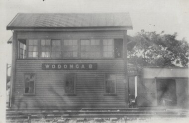
Photograph - Fred Rochow Railways Collection - Signal Box B, Wodonga Station, Before 1964
The Fred Rochow Railways Collection incorporates photos related to the operation of the Wodonga Railway Station including different types of trains and railways staff C. 1930 – 1990. It was donated to the Wodonga Historical Society by Fred Rochow, a railwayman who spent many years based in Wodonga. He joined the Victorian Railways on 17th June l947 and retired in 1988. For some time, he was a member of the Australian Federated Union of Locomotive Enginemen and served a term as a member of the Trades Hall Council. He had an extensive knowledge of the struggles that took place to achieve better conditions for railway workers. Fred worked for many years as a fireman and then worked his way up the ranks to driver, experiencing many changes from the days of steam locomotives through to diesel trains, locomotives and even the modern XPT train. He worked throughout Victoria at different stages of his career, with his final working years focused on the northeast of Victoria and the Albury to Melbourne line. After his retirement, Fred continued to share his love of steam miniature trains with the community.This collection has local and statewide significance as it captures images of trains, locomotives and personnel who operated the railway services in Wodonga and throughout Northeast Victoria. The railways played a critical role in opening up Victoria and connecting Australia for trade, business, social communication and transport.Signal Box B was located on the south-east side of the High Street level crossing and controlled the High Street gates. A big wheel was used to operate the gates. The Signal Box B was demolished on May 10th, 1964, when the standard gauge line to Albury was completed. On front of building "WODONGA B"railways wodonga, fred rochow, wodonga signal box b -
 Rutherglen Historical Society
Image, Olive Codling
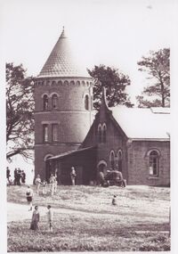
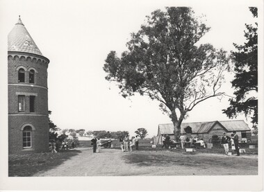
One of the buildings of the Mount Ophir winery. Photo was taken by Miss Olive Codling, who was a life member of the Wodonga Historical Society. Photograph is believed to have been taken on the occasion of a Tour by the North East Branch, 1st combined meeting.Black and white photograph of a brick building with a tower. A number of people are walking about by the buildings. This photograph is one of two printed on a single sheet of photographic paper.mt ophir, mount ophir, wine industry -
 Rutherglen Historical Society
Image, Olive Codling
Some of the buildings of the Mount Ophir winery. Photo was taken by Miss Olive Codling, who was a life member of the Wodonga Historical Society. Photograph is believed to have been taken on the occasion of a Tour by the North East Branch, 1st combined meeting.Black and white photograph of several buildings. On the left is a brick tower building. To the right, in the background, is a timber shed. A number of people are walking about or are seated at tables.mt ophir, mount ophir, wine industry -
 Wodonga & District Historical Society Inc
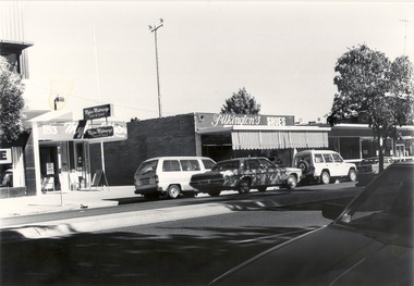
Photograph - Codling Collection 01 - Wodonga, High Street West - Mylons, Pilkington's, S.E.C, 1980s
Miss Olive Codling was a Foundation Member and a Life Member of the Wodonga Historical Society. Many of her prize-winning photos are held in the Society Collection. She also held a range of roles and committee positions in a wide range of Wodonga community organisations. These included the Horticultural Society, the Wodonga Arts Council, the Wodonga Camera Club and the Wodonga Lapidary Club. This photo collection is significant as it documents how the businesses and buildings in Wodonga have evolved and contributed to community throughout the 20th century.Wodonga, High Street West Businesses include Mylon Motorways and Pilkington shoes. 153 High Street, Wodonga in 2021is now the location of Gateway Health and other allied Health Services. In 1906 Patrick Mylon started a passenger transport service in the Albury-Wodonga border area with horses and cabs. His son Jack went into business in the late 1920s, and his grandson Bernie joined the firm early in 1970. When Patrick started with the horses and cabs, each cab carried eight passengers and he always had two horses per cab. As the business expanded, Mylons used a range of buses and coaches including Reo, Chev and Bedford vehicles. During more than 100 years if service to the Wodonga region and beyond, Mylon Motorways received many awards for Excellence and tourism. On July 2, 2008 the company, including its 31 buses and 45 staff members were transferred to the Dyson Group. On building facades on left "153 Mylon Motorways/Tours and Travel" On building on the right "Pilkington's SHOES"wodonga businesses, high st wodonga, pilkingtons shoes, mylon motorways -
 Tarnagulla History Archive
Photograph of stables behind bank building, Tarnagulla, Stables behind bank building, Tarnagulla, circa 1970s
... buildings ...Murray Comrie Collection. This image depicts the stables at rear of a two-storey bank building in Tarnagulla. The bank building was used first by the Colonial Bank of Australasia (from 1866 to 1888) and then by the Union Bank (from 1888 to 1942). The two-storey bank building was built in 1866 by the Colonial Bank of Australasia. Before this, the site had been occupied by Foo's shop. Whilst it was being built, the Colonial Bank operated from Company's Hotel (later known as Burstall Hall and the Council Chambers). The new double-storey building was used by the Colonial Bank from 1866 until 21st February, 1888. The premises were sold to the Union Bank for £2500. The Union Bank moved in and commenced operations on 6th June 1888, continuing until 1942. The building was later used as a general store until the 1990s. It is now a private residence. This is a reasonable copy of an older original. Copy probably made by Murray Comrie in the 1970s. Monochrome photograph depicting stables at rear of the double-storey bank building in Tarnagulla. Image depicts a brick building with white timber doors and corrugated metal roof. The site was originally built by and for the Colonial Bank and later used by the Union Bank. tarnagulla, banks, banking, commerce, buildings, commercial road, horses, stables -
Tatura Irrigation & Wartime Camps Museum
Photograph - original, Tatura Museum Restoration, 1991
North east view of new room Tatura Museum adjoining present building. B. Doller's car in foreground. Jacaranda tree at left. A. Knee working on scaffolding.Colour photograph of exterior of new building. Tatura Museum 1991on back: Tatura Museum extension 1991. tatura museum -
 Kinglake Historical Society
Kinglake West Primary School
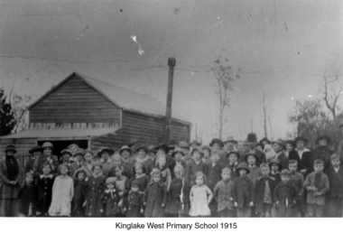
Photograph of original Kinglake West Primary (State) School building with children and families. School built in 1896 by the pioneering families as Education Department would not build a school. Built on land selected by the Snell family.Only known photograph of the original school buildingPhotograph of original Kinglake West Primary School building education, school, pioneers, kinglake west -
 Bacchus Marsh & District Historical Society
Photograph, Police Barracks Main Street Bacchus Marsh 1883
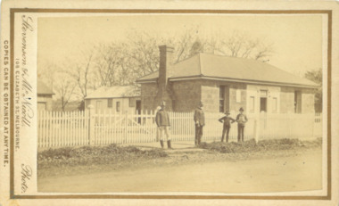
The Bacchus Marsh Police Barracks shown in this image were located in Main Street on the site of the present day Police Station. The Barracks were constructed around 1857 or 1858. Prior to this the Police were stationed in the Police Paddocks at Maddingley in the area where Maddingley Park is now located. This building was in use by the Police until 1930 when it was replaced by a new building. This later building was in use until the early 2000s but was demolished in 2003 and replaced by a larger Police building.Small sepia unframed photograph on card with gold border framing photograph. Housed in the album, 'Photographs of Bacchus Marsh and District in 1883 by Stevenson and McNicoll'. The image shows the Bacchus Marsh Police Police Barracks and stables in 1883. Two uniformed male police officers wearing helmets can be seen standing on the footpath in front of the building. Next to them on their left stand two boys, one holding a document, possibly a newspaper.. The Barracks is a sandstone building with a chimney on one side; it appears to have a slate roof. Two buildings can be seen behind the main building. A white picket fence with a double gate runs along the front of the complex.On the front: Stevenson & McNicoll. Photo. 108 Elizabeth St. Melbourne. COPIES CAN BE OBTAINED AT ANY TIME. On the back: LIGHT & TRUTH inscribed on a banner surmounted by a representation of the rising sun. Copies of this Portrait can be had at any time by sending the Name and Post Office Money Order or Stamps for the amount of order to STEVENSON & McNICOLL LATE BENSON & STEVENSON, Photographers. 108 Elizabeth Street, MELBOURNE. stevenson and mcnicoll 1883 photographs of bacchus marsh and district, bacchus marsh police station, police stations, police -
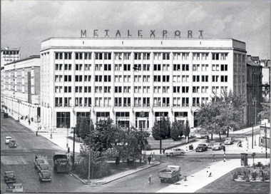 National Wool Museum
Postcard
Postcard of the Metalexport building in Warsaw, Poland. Metalexport was the sole exporter of textile machinery from Poland.Postcard of the Metalexport building in Warsaw, Poland, 1959. Metalexport was the sole exporter of textile machinery from Poland. Back of a postcard of the Metalexport building in Warsaw, Poland, 1959. Metalexport was the sole exporter of textile machinery from Poland.METALEXPORTtextile machinery, metalexport -
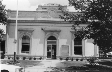 Stawell Historical Society Inc
Photograph, Stawell Shire Hall Built in 1866
Stawell Shire Hall built 1866. These photographs of the Shire Hall, Longfield Street Stawell. This building has had many changes since 1866. Ronald Campbell, the Shire's second president laid the foundation of the hall on 28th April 1866. The contractors were Hutchings and Delbridge. The first Hall and office were the front part of the existing building. These rooms consisted of two 18 ft square rooms with an entrance hall separating them. The facade was almost the same as it is today. The building cost 502 pounds. Black and white photograph of a brick building which has been cement rendered with a parapet on top. The front of the building has 2 arched windows and arched entrance door. A glass notice board to the right of the door. Shire Hall 1866 is written on the top front of the building. Many small flower pots line either side of the front entrance with a flag post in the lawn on the left. stawell -
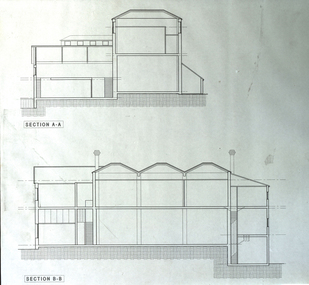 Federation University Historical Collection
Plan - Plans, Ballarat School of Mines Old Chemistry Building Refurbishment Plans
The Old Chemistry Building on the Federation University Australia SMB campus is one of the earliest remaining buildings used at the Ballarat School of Mines.Digital copies of refurbishment plans for University of Ballarat's refurbishment plans for the Old Chemistry Building, Ballarat School of Mines Campus.ballarat school of mines, old chemistry building, refurbishment, smb campus -
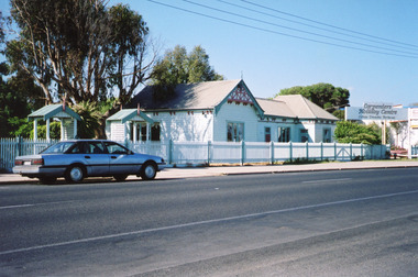 Lakes Entrance Regional Historical Society (operating as Lakes Entrance History Centre & Museum)
Photograph - Historic House, Fish, Marie, 2002c
This building was the home of the Carpenter family for about 80 years, converted to a restaurant known as 'Skippers', relocated as a private residence in 2003, whole lot demolished to make way for the Lakes Entertainment Centre.|This is the before paired photograph used in the 150 year Lakes Entrance 1858-2008 display.|The after paired photograph number is 01447.1|Also one 12 x 16 framed photograph used in room display.Colour photograph of a weatherboard building on Esplanade. The building has an iron roof, picket fence at front. Carpenters Holiday Centre sign to east of building. Motor vehicle parked on street. Lakes Entrance VictoriaCarpenters Holiday Centre houses, room display, local history -
Port Melbourne Historical & Preservation Society
Photograph - Ventilation cover, ASTA buiding, Fishermen's Bend, David Thompson, Aug 1998
Examples of 'art deco' buildings and motifs around Port Melbourne were drawn from David Thompson's existing collection and augmented by shots taken in August 1998.From series of 'deco' detailing and buildings taken by David Thompson for use in PMH&PS 1999 calendar, taken in August 1998: Ventilator cover - detail of ASTA building, Fishermen's BendDetails in pen on backarchitecture, built environment - industrial, david thompson, asta -
 Port Melbourne Historical & Preservation Society
Photograph - GMH administration buiding at night, Salmon Street, Port Melbourne, David Thompson, Aug 1998
Examples of 'art deco' buildings and motifs around Port Melbourne were drawn from David Thompson's existing collection and augmented by shots taken in August 1998From series of 'deco' detailing and buildings taken by David THOMPSON for use in PMH&PS 1999 calendar, taken in August 1998: GMH administration building, night view from eastDetails in pen on backarchitecture, built environment - industrial, david thompson -
 Kiewa Valley Historical Society
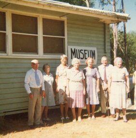
Photograph of local residents at Tawonga Caravan Park Museum Building, 11th February, 1979
Pictorial record of residents of the Kiewa Valley in the late 1970's and early buildings Pictorial record of residents of the Kiewa Valley in the late 1970's Colour photograph of local residents standing outside the Museum building at Tawonga Caravan ParkHandwritten on back of photograph in blue ink: Q Baldwin, C Joung, Gwen Hobbs, Mrs Van De Wyde, T & M Wallace and Mrs Temple. Taken by C Roper on 11th February, 1979tawonga caravan park, kvhs members, kiewa valley -
 Clunes Museum
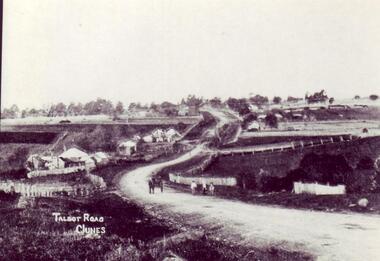
photograph
OWNED AND RUN BY JOHAN CONRAD WEICKHARDT UNTIL 1905. BUILDING NO LONGER IN EXISTENCE.AN EARLY PHOTOGRAPH COPY OF TALBOT ROAD CLUNES. BRITISH HOTEL, FIRST BUILDING ON LEFT.local history, photography, photographs, clunes landscape -
 Hume City Civic Collection
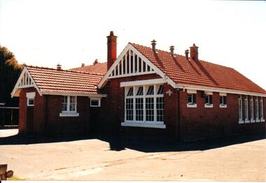
Photograph, early 1990s
The brick building was constructed in 1911/1912 and replaced an earlier school building. In 1942/43 the school building was extended to cope with the increased population in Sunbury. The State School remained on the Macedon Street site until 1999 when it was relocated to the restored former Industrial School at Jacksons Hill.A coloured photograph of the former Sunbury State School No. 1002. It is a red brick Federation building with a red terracotta tiled roof and wooden white painted trims. There are two stepped brick chimneys with terracotta chimney pots and six air vents protruding from the roof. There is a small porch at the front of the building.carirns, j. f. dr., eadie, peter, education department, george evans collection -
 Wodonga & District Historical Society Inc
Photograph - Carkeek's Terminus Hotel, Wodonga, C. 1906 - 1909
The Terminus Hotel, Wodonga was built by James Thompson Hatch in 1873, the same year the railway reached Wodonga from Melbourne. It was named due to its close proximity to the railway terminus. It was sold to Messrs George Day and Kenneth McLennan of Albury. It was first licenced to J.G. Morton in January 1874. Annie Allen, from Ireland, took over as licensee of the hotel containing 14 rooms in 1879, after she and her husband, George James Allen, purchased it. In 1887 they added a new wing on the south boundary of the property next to Peter McLean’s store at 81 Sydney Road. The architects for the new wing were Gordon and Gordon. A billiard room, a dining room, and 18 other rooms were added on the vacant block of land between the Hotel and the Bank of Victoria. A balcony 6 feet wide was added on the north side. Included in the plans was the latest patent elevator, later known as a dumb waiter. Allen died in 1889 aged 52, and Annie Allen continued to run the Terminus. She later married John G. Haldon and was licensee of the hotel until December 1898 when the licence was transferred to William Carkeek. Carkeek, from Cornwall, arrived in the colony around 1860 and is considered one of the founders of Tallangatta. In November 1903, the license was transferred to Daniel Crawford, then in 1906 it was transferred to Mr Stephen Carkeek. In 1916 it passed into the hands of Mr H. W. Allen of Rutherglen, son of Mr George James Allen. On 1st June 1998 the Terminus Hotel was destroyed by fire. Estimates of damage range from between a conservative $750,000 to as high as $2 million. The remains of the building were demolished in 1999.The Terminus Hotel was one of the earliest hotels in Wodonga with clear links to the establishment of the railway line. It was an important business and meeting place for social gatherings.On 21 December 1898 an application to transfer the license of the Terminus Hotel from Mrs Annie Haldon to Mr William Carkeek was lodged This was granted by the Wodonga Licensing Court on 12 January 1899. In February of that year, it was transferred to Mrs. Rebecca Carkeek. William Carkeek died on 17 March 1900, aged 57 years. In November 1900 Mr. Daniel Crawford took over the license. In March 1906, the Carkeek family returned to the Terminus Hotel when their son Stephen purchased the business. In January 1909, tenders were invited for Freehold Purchase of the property. It was available on a 7 year lease at a rental of £9 per week In 1913 Stephen Carkeek disposed of the goodwill of the business to Mr Wilson of Grenfell, New South Wales, thus ending the Carkeek family’s long association with the Terminus Hotel. He died in Beechworth on 16 May 1928.Across side of building "CARKEEK'S TERMINUS FAMILY HOTEL"hotels wodonga, businesses wodonga, terminus hotel wodonga, william carkeek -
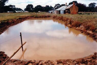 Hume City Civic Collection
Photograph, Early 1980's
The mud brick cottage and outbuilding was possibly built by James Waylett in the 1850's and it is only one of three remaining mud brick buildings in the Oaklands-Greenvale which were constructed in the late 19th Century.A coloured photograph of farm scene. A dam is in the foreground and the remains of a mud brick cottage and timber and corrugated building in the middle distance. Further farm buildings can be seen in the distance.mud brick buildings, waylett, james, farm buildings, sherwood, somerton road, oaklands hunt club, george evans collection -
 University of Melbourne, Burnley Campus Archives
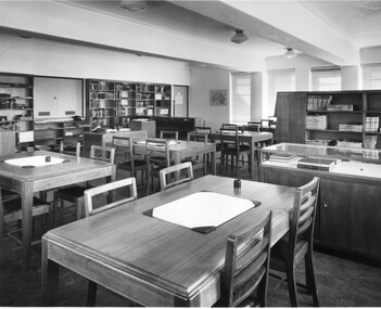
Photograph - Black and white print, Commercial Photographic Co. Pty. Ltd, Library, 1949
Note by T.H. Kneen 26.2.1992, Library in new College building immediately after occupation in 1949. Note inkwells carried over from Commonwealth Reconstruction Training Scheme which operated from 1946-1951.Black and white photograph. Old library in the Administration Building On reverse, Commercial Photographic Co. Pty. Ltd. 217 Queensberry Street, Carlton, Melbourne, N.#. FJ 5266 When Ordering Further Prints Please Quote-No K370-3.inkwells, commonwealth reconstruction training scheme, old library, administration building -
 Vision Australia
Photograph - Image, Royal Blind Society of New South Wales
... Buildings ...Colour photograph taken of the Royal Blind Society of New South Wales building in Enfield, as viewed from Henley Park. A red buildng with grey stairwells and window fixtures, surrounded by a concrete balcony that overlooks the park. Digital Image of Enfield building taken from parkroyal blind society of new south wales, buildings -
 Vision Australia
Photograph (item) - Image, Jason Morgan, Blind Cricketers pavilion, oval and rear view of Glenferrie Road building, 18/10/2023
... Buildings ...Photograph taken by a staff member of the rear view of the Kooyong building, facing the blind cricket ground. The Charlie Bradley Cricket Pavilion is to the left.vision australia, buildings -
 Sunbury Family History and Heritage Society Inc.
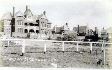
Photograph, Asylum Sunbury
The administrative building along with four other buildings were part of the former Sunbury Asylum complex that operated in Sunbury on Jacksons Hill from 1876 to 1992. The white fence in the front of the photo was the boundary for The Pines golf club where patients, staff and Sunbury residents played before the Goonawarra Golf Club was established.The Sunbury Asylum was an important institution in the town and many of the townspeople worked there over the 120 years of its operation.A non-digital sepia photograph in post card format with a white border across the bottom, of the administrative building and other brick Victorian style buildings that were part of the Sunbury Asylum complex. A white post and rail fence is in the foreground. sunbury asylum, caloola, the pines golf club -
 Stawell Historical Society Inc
Photograph, Salvation Army -- Crowd at Opening of Citadel Main Street Stawell 1934
Salvation Army Crowd at Opening of Citadel Main Street in 1934. A large crowd in front of new building. The photo was taken on the opening of the Citadel, December 1934.Black and white photo depicting a large group of people out the front of a brick building. Large windows are either side of the building entrance and written above the arched doorway, The Salvation Army Citadel. Weather board house to the left, also to the right a weather board building with a sign "Entrance to Peoples Hall Primary Section". W.J. Chapman Photo Artist Stawell. Reeve opening of Citadel December 1934 in pencil.stawell religion -
 Bendigo Military Museum
Photograph - Printing Building, Lithographic Squadron - Army Survey Regiment, Fortuna, Bendigo, c1986
This is a set of ten photographs of Lithographic Squadron’s Printing Building at the Army Survey Regiment, Fortuna, Bendigo, c1986. The building was originally George Lansell’s gold crushing battery. When the Army took possession of Fortuna in 1942, it was modified with reinforced concrete floors to house the heavy-duty printing equipment. An additional building was purpose built on the eastern side of the printing building in 1987 to house a new computer-controlled Heidelberg Speedmaster five colour lithographic offset Printing Press. See item 6131.18P for photos of foundation preparation for the new building. This is a set of ten photographs of Lithographic Squadron’s Printing Building at the Army Survey Regiment, Fortuna, Bendigo, c1986. Black and white photographs are on 35mm negative film and scanned at 96 dpi. They are part of the Army Survey Regiment’s Collection. .1) to .10) - Photos, black & white, c1986. Lithographic Squadron’s Printing Building.There are no annotations with the photos. royal australian survey corps, rasvy, army survey regiment, army svy regt, fortuna, asr, litho sqn, litho -
 Kew Historical Society Inc
Plan, Melbourne & Metropolitan Board of Works : Borough of Kew : Detail Plan No.1576, 1904
The Melbourne and Metropolitan Board of Works (MMBW) plans were produced from the 1890s to the 1950s. They were crucial to the design and development of Melbourne's sewerage and drainage system. The plans, at a scale of 40 feet to 1 inch (1:480), provide a detailed historical record of Melbourne streetscapes and environmental features. Each plan covers one or two street blocks (roughly six streets), showing details of buildings, including garden layouts and ownership boundaries, and features such as laneways, drains, bridges, parks, municipal boundaries and other prominent landmarks as they existed at the time each plan was produced. (Source: State Library of Victoria)This plan forms part of a large group of MMBW plans and maps that was donated to the Society by the Mr Poulter, City Engineer of the City of Kew in 1989. Within this collection, thirty-five hand-coloured plans, backed with linen, are of statewide significance as they include annotations that provide details of construction materials used in buildings in the first decade of the 20th century as well as additional information about land ownership and usage. The copies in the Public Record Office Victoria and the State Library of Victoria are monochrome versions which do not denote building materials so that the maps in this collection are invaluable and unique tools for researchers and heritage consultants. A number of the plans are not held in the collection of the State Library of Victoria so they have the additional attribute of rarity.Original survey plan, issued by the MMBW to a contractor with responsibility for constructing sewers in the area identified on the plan within the Borough of Kew. The plan was at some stage hand-coloured, possibly by the contractor, but more likely by officers working in the Engineering Department of the Borough and later Town, then City of Kew. The hand-coloured sections of buildings on the plan were used to denote masonry or brick constructions (pink), weatherboard constructions (yellow), and public buildings (grey). Development in the 20th century has irreparably altered that part of Kew represented in this plan. In the block bounded by Cotham Road, Charles Street, Wellington Street and Gellibrand; just one house standing in 1903 remains. This block included two of the most historic houses in Kew: ‘Ordsall’ (later ‘Southesk’) and ‘Madford’ (previously ‘Elm Lodge’). Ordsall was the home of the second chairman of Kew, John Halfey. It contained some of the most significant interior murals in Kew, created for Halfey by artists working for Cullen & Co. It was demolished in 1960 to make way for the Kew Civic Centre. Elm Lodge had been built for William Siddeley in ca. 1864. Arthur Septimus King purchased it in 1874. The lower paddocks of Madford were sold in 1905 by his wife to the Borough of Kew and, after landscaping by George and Thomas Pockett, opened as the Alexandra Gardens in 1908. Elm Lodge/Madford was in 1922 to become St. Anthony’s Home for Little Children before its subsequent demolition in the 1980s.melbourne and metropolitan board of works, detail plans, maps - borough of kew, mmbw 1576, cartography -
 Kew Historical Society Inc
Plan, Melbourne and Metropolitan Board of Works, Melbourne & Metropolitan Board of Works : Borough of Kew : Detail Plan No.1294 & 1295, 1904
The Melbourne and Metropolitan Board of Works (MMBW) plans were produced from the 1890s to the 1950s. They were crucial to the design and development of Melbourne's sewerage and drainage system. The plans, at a scale of 40 feet to 1 inch (1:480), provide a detailed historical record of Melbourne streetscapes and environmental features. Each plan covers one or two street blocks (roughly six streets), showing details of buildings, including garden layouts and ownership boundaries, and features such as laneways, drains, bridges, parks, municipal boundaries and other prominent landmarks as they existed at the time each plan was produced. (Source: State Library of Victoria). This plan forms part of a large group of MMBW plans and maps that was donated to the Society by the Mr Poulter, City Engineer of the City of Kew in 1989. Within this collection, thirty-five hand-coloured plans, backed with linen, are of statewide significance as they include annotations that provide details of construction materials used in buildings in the first decade of the 20th century as well as additional information about land ownership and usage. The copies in the Public Record Office Victoria and the State Library of Victoria are monochrome versions which do not denote building materials so that the maps in this collection are invaluable and unique tools for researchers and heritage consultants. A number of the plans are not held in the collection of the State Library of Victoria so they have the additional attribute of rarity.Original survey plan, issued by the MMBW to a contractor with responsibility for constructing sewers in the area identified on the plan within the Borough of Kew. The plan was at some stage hand-coloured, possibly by the contractor, but more likely by officers working in the Engineering Department of the Borough and later Town, then City of Kew. The hand-coloured sections of buildings on the plan were used to denote masonry or brick constructions (pink), weatherboard constructions (yellow), and public buildings (grey).The streets and built structures in MMBW Detail Plan 1294 & 1295 were surveyed in 1903 and released to contractors in 1904. This plan is one of two in the collection where the lithographers amalgamated two separate plans. Both plans include sections of Studley Park. Dominating the south and west corners of Kew Junction are the Clifton and Kew Hotels. The Kew Hotel, owned by Patrick O’Shaughnessy was one of the oldest in Kew. MMBW plans were amended over time to take account of new subdivisions such as that which created Merrion Place. Of the four mansions shown in Studley Park Road, three remain – ‘Field Place’, the home of Frances Henty, ‘Leaghur’ and ‘Darley’. ‘Byram’ (later ‘Goathland’, then ‘Tara Hall’) was an architectural marvel. Designed in 1888 by E.G. Kilburn for the paper magnate George Ramsden, it was demolished in 1960. While an earlier sale of the southern section of Byram had created Tara Avenue in 1927, the demolition of the house in 1960 enabled the extension of Tara Avenue northward.melbourne and metropolitan board of works, detail plans, mmbw 1294, mmbw 1295, cartography