Showing 13425 items
matching golden-gate-bridge
-
 Mission to Seafarers Victoria
Photograph - Photograph, Black and white, Allan Charles Quinn, 30 September 1949
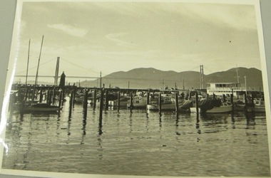
Alan Charles Quinn went to sea at 16 years of age and photographed his work and the places he visited. His collection of photo albums form a pictorial autobiography. The Alan Charles Quinn collection also includes a series of letters written to and from his mother.Black and white photograph of a boats in a harbour in San Francisco. In the background there are hills and the Golden Gate Bridge. The picture shows a large number of small boats and one which is slightly bigger boat. Blue/green ink, handwritten on reverse: "30/9/49 S.F" Handwritten in pencil: "K8/B"san francisco, moorings, boats -
 Eltham District Historical Society Inc
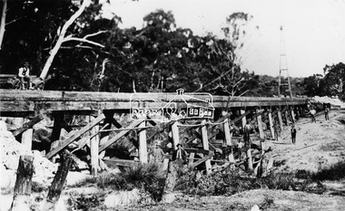
Photograph, Railway Bridge construction between Eltham and Hurstbridge, c.1912
The railway was extended from Eltham to Hurstbridge in 1912. This bridge is most likely near Allendale Road, Diamond Creek. It was one of four original trestle bridges in the stretch north of Allendale Road, which were all burnt out in January 1969 (replaced by two steel bridges and two corrugated iron culverts).This photo forms part of a collection of photographs gathered by the Shire of Eltham for their centenary project book,"Pioneers and Painters: 100 years of the Shire of Eltham" by Alan Marshall (1971). The collection of over 500 images is held in partnership between Eltham District Historical Society and Yarra Plenty Regional Library (Eltham Library) and is now formally known as the 'The Shire of Eltham Pioneers Photograph Collection.' It is significant in being the first community sourced collection representing the places and people of the Shire's first one hundred years.Digital image One 4 x 5 inch B&W negative One 9 x 12.5 cm printshire of eltham pioneers photograph collection, hurstbridge, allendale road, hurstbridge railway extension, railway bridge, railway line construction, trestle bridge, diamond creek (creek) -
 Eltham District Historical Society Inc
Postcard - Photograph postcard, Old Bridge, Kaylock's Crossing, Brougham Street, Eltham, c.1912
Date estimated to be circa 1912 based on the style of printing on the reverse of the card - Kodak Austral paper for real photo postcards, the paper was manufactured c.1908-1914 (See also POSTCARDS ON KODAK PAPER - IS IT POSSIBLE TO "DATE" THEM? http://tps.org.au/bb/viewtopic.php?t=115) Brougham Street was created in Josiah Holloway's 1851 subdivision of Little Eltham. It was one of several east-west streets shown on the subdivision plan as crossing the Diamond Creek. The western part was named Wellington Street on the subdivision plan but was later changed to conform with the name of the eastern part as acknowledgement of the continuity of the street. It is not known when the first bridge was constructed in Brougham Street however it was certainly mentioned at Council’s meeting of 2 June 1884 as being in a dangerous state of repair. This photo (c.1895) of an old bridge shows a very low-level simple log girder bridge crossing the creek at a right angle and so the approaches involved bends in the road alignment. This bridge was generally known as Kaylocks Bridge or Kaylock’s Crossing after the owner of the adjoining land. It was most likely built from around the mid-1850s, or a crossing of some fashion established as Richard George Kaylock, butcher of Little Eltham and his wife Emily Ann settled there in 1854. His property was in Wellington Street (now Brougham Street) and apparently extended across the Diamond Creek. The land on the western side of the creek was farmed, the house being on the eastern side. Kaylock's Bridge formed part of the original coach road to Eltham and in 1922 was described as an "old rustic bridge". Its low level and insubstantial construction made it susceptible to flood damage, necessitating frequent closures until repairs could be carried out. In September 1922, Council called for tenders for a new timber bridge to be constructed at Kaylock’s crossing. An engineering assessment carried out for the Council by Macleod Consulting at the time of the replacement suggested that the construction details indicate that it was in the 1900s, however this dating could possibly have been the result of numerous repairs undertaken over the years to flood damage. The tender was awarded to Mr Weller of Kangaroo Ground who commenced work in February 1923 on a higher-level timber trestle bridge. Work was slowed due to illness of the contractor and the accidental death of a man in March 1923 following the collapse of the bank after he had jumped into a hole that had just been blasted. The bridge was completed around July 1923 at which point the old structure was pulled up, marking what was described in the ‘Advertiser’ newspaper as the passing of an old and well-loved landmark in the district. In April 1924 the approach to Kaylocks bridge was washed away during the heavy flooding that destroyed the Main Road bridge. The western side was repaired, and an extra span was added to the eastern side using timber from the destroyed Main Road bridge. The bridge was again severely damaged four months later in August 1924 When a lack of finances delayed repairs to the Bridge Street bridge in 1931 (also referred to as Obelisk Bridge at the time), traffic had to detour via Brougham Street for some time. Local residents feared that the Bridge Street bridge might never reopen. Kaylocks Bridge was constantly subject to damage by floods. In the 1934 flood it was submerged by two feet of water. In more recent times the bridge was again severely damaged by flooding and repairs made. A new bridge and adjoining footbridge were constructed in 2009.Digital file only Postcards scanned from the collection of Michael Aitken on loan to EDHS, 2 Sep. 2022michael aitken collection, eltham, postcards, bridge, brougham street, diamond creek (creek), kaylocks bridge, wellington street -
 Eltham District Historical Society Inc
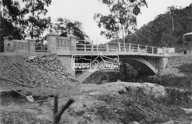
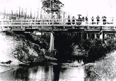
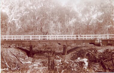
Negative - Photograph, New bridge at Hurstbridge, 1917
The newly constructed re-inforced concrete arched bridge across the Diamond Creek at Hurstbridge designed by John Monash. Eltham Shire shared the cost of the construction of the bridge with Heidelberg and Whittlesea Shires. The bridge was officially opened on 3rd November 1917. Part of a slide show presentation "Bridges & Waterways of the Shire" by Russell Yeoman to the 13 September 1989 Society meeting. The presentation included slides of historic photos from the Shire of Eltham Pioneers collections as well as several recent views.This photo forms part of a collection of photographs gathered by the Shire of Eltham for their centenary project book, "Pioneers and Painters: 100 years of the Shire of Eltham" by Alan Marshall (1971). The collection of over 500 images is held in partnership between Eltham District Historical Society and Yarra Plenty Regional Library (Eltham Library) and is now formally known as 'The Shire of Eltham Pioneers Photograph Collection.' It is significant in being the first community sourced collection representing the places and people of the Shire's first one hundred years.Digital image 4 x 5 inch B&W Negshire of eltham pioneers photograph collection, hurstbridge, bridge, 1917, diamond creek (creek), monash bridge -
 Emerald Museum & Nobelius Heritage Park
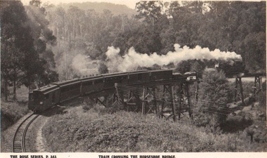
Photograph/postcard, Rose Series Postcards - Local views Barnett donation, circa 1940 - 50
Photograph/postcard of Puffing Billy crossing the trestle bridge over Belgrave/Gembrook Road, SelbyPhotograph/postcard - Rose Series (p. 343) depicting Puffing Billy crossing the Trestle Bridge BelgraveFront: The Rose Series P 343 Train Crossing Horseshoe Bridge Back: Manufacturer's details as per listed puffing billy, rose series postcards -
 Eltham District Historical Society Inc
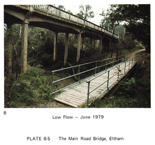
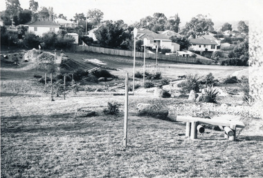
Work on paper (Sub-Item) - Photograph, Main Road Bridge, Eltham low flow of Diamond Creek, June 1979
Colour photograph.Main Road Bridge, Eltham low flow of Diamond Creek with wooden pedestrain bridge constructed over the creek as a continuation of the walking and biking trail, June 1979diamond creek, eltham, bridge, main road, pedestrain bridge, trail -
![Newspaper Clipping - Digital Image, Bridge-over-rail job to cost $254,000, 1974 [Main Street Greensborough], 24/09/1974](/media/collectors/4f729f5697f83e03086015b8/items/5eb5f55721ea671f1807c4cf/item-media/5eb5f5e021ea671f18088f90/item-fit-380x285.jpg) Greensborough Historical Society
Greensborough Historical SocietyNewspaper Clipping - Digital Image, Bridge-over-rail job to cost $254,000, 1974 [Main Street Greensborough], 24/09/1974
In 1974 the proposed road over rail bridge in Main Street Greensborough was estimated to cost $254,000. The reconstruction of the bridge was necessary for the duplication of the rail line between Macleod and Greensborough.News clipping, black and white text. hurstbridge rail line, greensborough station, main street greensborough -
 Malmsbury Historical Society
Photograph (Item), Malmsbury Gutters Near Coliban Bridge, Malmsbury ca1990
Buildings - Coliban Bridge -
 Greensborough Historical Society
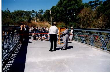
Photograph - Digital Image, Anne Paul, Opening of restored Old Lower Plenty Bridge 2001, 14/03/2001
The opening of the restored Old Lower Plenty Bridge, opened on 14/03/2001 by the Minister for Environment and Conservation Sherryl Garbutt MLA and Mayor of Banyule Cr Dale Peters. The project was jointly funded by Banyule Council and Parks Victoria. The restored bridge is the oldest remaining bridge in the former Shire of Eltham and forms part of the Plenty River Trail.Digital copy of colour photographlower plenty, lower plenty bridge, sherryl garbutt, dale peters, banyule council, parks victoria -
Ballarat Tramway Museum
Functional object - Deck Bridge
Trolley Deck Bridge. Multiple such bridges are used to support the Trolley Deck on roof of tramcar.MELB W4 TROLLEY DECK "BRIDGE'melbourne, w4, trolley deck bridge -
 National Vietnam Veterans Museum (NVVM)
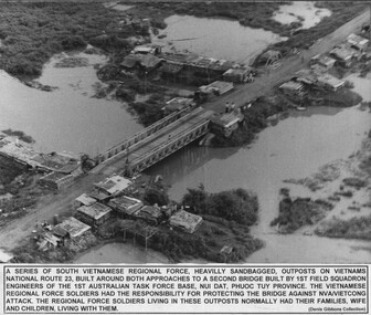
Photograph, National Route 23 Bridge
A black and whitie Photograph of A series of South Vietnamese Regional Force heavily sandbagged outposts on Vietnams National Route 23, built around both approaches to a second bridge built by 1st Field Sqn Engineers of the 1st Australian Task Force soldiers had the responsibility for protecting the bridge against NVA/VietCong attack. The Regional Force soldiers living in these outposts normally had their families, wives and children, living with them.photograph, south vietnamese regional force, national route 23, 1st field sqn engineers, 1st atf base, nva/vc, gibbons collection catalogue, regional force soldiers -
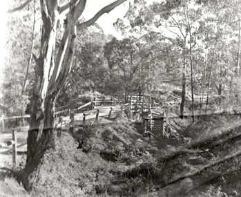
 Eltham District Historical Society Inc
Negative - Photograph, J.A. McDonald, One Tree Hill Road Bridge, Christmas Hills, 2 July 1962
One Tree Hill Road Looking south 2/7/62 The bridge was destroyed by bushfires 15-16 January 1962. A temporary bridge was set up to the east sideRecord of various Shire of Eltham infrastructure works undertaken during the period of 1952-1962 involving bridge and road reconstruction projects, sometimes with Eltham Shire Council Project Reference numbers quoted. It was during this period that a number of significant improvements were made to roads and new bridges constructed within the shire that remain in place as of present day (2022). In many situations, the photos provide a tangible visible record of infrastructure that existed throughout the early days of the Shire. The album was put together by or under the direction of the Shire Engineer, J.A. McDonald.1962-07-02, bridge construction, christmas hills, infrastructure, shire of eltham, victorian bushfires - 1962, bush fires, one tree hill road, property damage -
 Eltham District Historical Society Inc
Photograph, Para Road Bridge construction, Briar Hill, near Greensborough, c.1971, 1971c
Three black and white photographs; two showing construction works of the bridge over the Plenty River at Briar Hill and one of Greensborough Park, Grimshaw Street, summer 1971-1972greensborough, briar hill, para road, bridges, construction, plenty river -
 Otway Districts Historical Society
Photograph, Gellibrand River railway bridge, 1901, 1901
Photograph, B/W, A4. Railway bridge over the Gellibrand River with people standing at the right-hand end, a railway water tank nearby on the left, and a tent underneath on the left.gellibrand, gellibrand river;railways; bridge; -
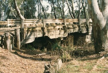
 Eltham District Historical Society Inc
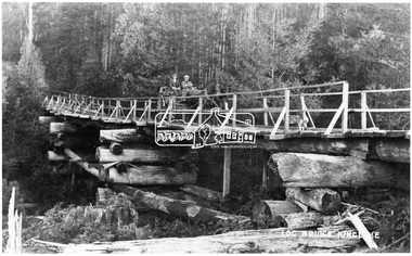
Negative - Photograph, Log bridge over Pheasant Creek, Kinglake, c.1920
Horse and cart with driver Mr. F. Thomson and passenger cross a wooden bridge with log tree trunk base construction supported by timber rails over Johnstone's Creek amidst the Kinglake forest. The bridge was built for the timber tramline. There was also a logging district in the Pheasant Creek area just outside the Shire of Eltham. Note dog also sitting on bridge.This photo forms part of a collection of photographs gathered by the Shire of Eltham for their centenary project book,"Pioneers and Painters: 100 years of the Shire of Eltham" by Alan Marshall (1971). The collection of over 500 images is held in partnership between Eltham District Historical Society and Yarra Plenty Regional Library (Eltham Library) and is now formally known as 'The Shire of Eltham Pioneers Photograph Collection.' It is significant in being the first community sourced collection representing the places and people of the Shire's first one hundred years.Digital image 4 x 5 inch B&W Neg 120 format B&W negative (spare) 2 x printsbridge, f. thomson, kinglake, log bridge, mr. munro, pheasant creek, pioneers and painters, shire of eltham pioneers photograph collection, timber tramway -
 Melbourne Tram Museum
Photograph, Cable tram 41 Bridge Road Richmond, c1900
The photograph shows cable, trailer 41 climbing the Bridge Road hill just west of Waltham Steet bound for the city. A second cable set can be seen in the distance, bound for Hawthorn Bridge. Nearly all of the buildings on this south side of Bridge Road remain today including the former Forbes and Sons building. Photo possibly dated c1900.Yields information about cable trams in Bridge Road Richmond and associated buildings.Photograph, black and white, plain papertrams, tramways, cable tram, bridge road, tram 41, richmond -
 Eltham District Historical Society Inc
Photograph, Russell Yeoman, Yarra Glen Road Bridge over Watsons Creek, Kangaroo Ground, c.1970, 1970c
Concrete bridge built in the 1920s.Roll of 35mm black and white negative film, 4 of 7 stripsIlford HP4bridge, bridges, watsons creek, eltham-yarra glen road, yarra glen road, kangaroo ground -
 Stawell Historical Society Inc
Photograph, Salt Creek Bridge 1993 -- Coloured
Salt Creek Bridge 1993stawell -
 Stawell Historical Society Inc
Photograph, Mokepilly Bridge 1908 -- Postcard
Mokepilly Bridge 1908 Postcardstawell -
 Wonga Park Community Cottage History Group
Photograph (Item) - Black and White, Wonga Park: Old Jumping Creek Bridge, c. 1931
Old Jumping Creek BridgePhoto is named 14880026.jpg on CD -
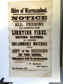 Warrnambool and District Historical Society Inc.
Document, Shire of Warrnambool Fire - Washing-Bridge 1882, 1882
This notice relates to the prohibition of lighting fires,drying clothes or bringing inflamable material near any of the bridges in the shire. Offenders will be prosecuted. With a date of 1882 and the fact that bridges were mostly made of wood, it would have been of concern that the destruction of bridges was not only of great inconvenience but also of considerable expense. But the reality of bridges providing shelter and warmth in the colder months and the ensuring fires and burnt bridges has more than likely precipitated this notice. J W Crawley was shire engineer from 1876 until 1895 and for 10 of those years he trained his son J W Crawley who succeeded his father and served in the position for 40 years.He in turn was succeeded by his son Rolf Crawley in 1935. In 1963 the bridge over the Hopkins Falls at Wangoom was named the Crawley bridge in honour of service to the Shire of Warrnambool by members of the Crawley family. The Shire of Warrnambool was proclaimed in 1863 and covered an area of over 600 square miles. Much of it was incorporated into the Moyne Shire in the 1990's with some being included into the boundaries of City of Warrnambool. This banner is an interesting piece of history. It shows the issues confronting early settlers such as shelter and the chores of daily life but also the importance placed on infrastructure which was slowly taking place around the district. It was in the era of drainage and roadworks and hence bridges were an important part of that infrastructure. The name J W Crawley is one of importance in the Warrnambool district for his service over many years. Rectangular piece of cloth printed in black ink. The back is plain.Shire of Warrnambool By order of J W Crawley Shire Engineer, 13th November 1882. Thos Smith gas Printing Works Koroit Street Warrnambool.warrnambool, shire of warrnambool, bridges of warrnambool shire, j w crawley, warrnambool shire engineer, crawleys of warrnambool -
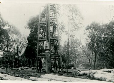 Orbost & District Historical Society
black and white photograph, C1890
This photograph shows the construction of the first bridge over the Snowy River at Orbost being built. a copy was also donated by Gil and Heather Richardson. The first pile bridge over the Snowy River was just completed by Mr Jim Granter when the 1891 flood took out the centre,. There were differences of opinion as to whether the council should pay . The Shire Secretary, Mr John Draffin, persuaded them to honour their obligations. Mr Granter and Mr Clarke finished it as a suspension bridge which was opened by Mrs William Watt. Soon after a mob of cattle stampeded, the weight snapped the cable, letting one side sag. Mr R.P. Cameron repaired it and this bridge remained until 1922. "In 1890 the contract for a bridge was let to Mr James Granter for £1450. This structure with additions and improvements made to it was to cost the ratepayers about £2,500, and its erection was proceeded with in a very satisfactory manner until, just as the greater-part of the work had been completed, the flood of 1891 came down on it, piling up mountains of logs, timber and debris against the piers, which had not been made wide enough apart to allow for. contingencies of this kind. The structure held out bravely until the turn of the flood and then gave way with a crash, about five bays from the centre disappearing in the stream." ( Snowy River Mail August 12 1893)This is a pictorial record of the construction of the first bridge over the Snowy River.A black / white photograph of four men working on the construction of a new bridge and its pylons a man is standing on a timber tower/ derrick. There are logs in the foreground, trees in the background. sheds on the left and possibly a steam engine.on back - "first bridge - 1st pile being driven"snowy-river-bridge granter-jim bridge -
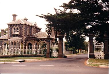 Hume City Civic Collection
Photograph, early 1990s
The Rupertswood Gatehouse, iron fence and gates are of state historical and architectural importance as they are probably the most distinctive structures of their type in Victoria.A coloured photograph of the Rupertswood Lodge, iron fence and gates. At the gateway there are double gates and two single gates on either side. The four gateposts are stone with a decorative finish on the top. The double gates are open so the roadway into the Rupertswood estate is visible.clarke, william john (sir), rupertswood gatehouse, salesian college, george evans collection -
 City of Kingston
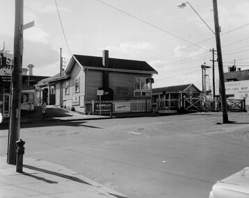
Photograph - Black and white, c. 1969
Black and white photograph of level crossing gates and railway station at Bentleigh at the intersection of Burgess Street and Centre Road. This image is part of a larger collection of images from the Public Transport Corporation displaying train stations and streetscapes in what is now the City of Kingston.Black and white photograph of level crossing gates and railway station at Bentleigh at the intersection of Burgess Street and Centre Road.Stamped in blue ink on reverse: COPYRIGHT / Public Transport Corporation / For re-ordering photographs / Please quote negative No H3405 / Enquiries C/- PTC Photographic Unit / Telephone switchboard 619 111 White paper adhered to reverse of photograph with black typed text: Railway gates, Centre Road Bentleigh / 1969 / $50 reproduction fee appliesbentleigh, railway station, railway crossing, suburbs, public transport -
 Eltham District Historical Society Inc
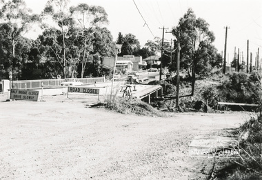
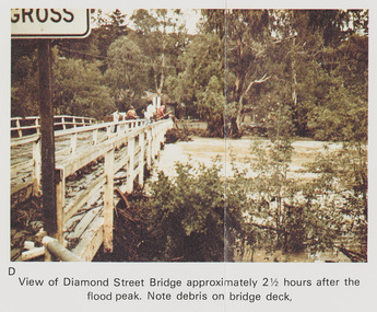
Work on paper (Sub-Item) - Photograph, Flooding, View of Diamond Street Bridge, Eltham 8 April 1977
Colour photograph. Flooding of Diamond Creek at Diamond Street Eltham bridge approximately 2 1/2 hours after the flood peak. Note debris on the bridge deck. 8 April 1977. flood, diamond creek, flooding, eltham, diamond street, bridge -
 Melbourne Tram Museum
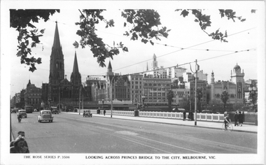
Postcard, Rose Stereograph Co, "Looking across Princes Bridge to the City, Melbourne", mid 1940s
Rose Series postcard No. P 3506 titled "Looking across Princes Bridge to the City, Melbourne", with W2 class 352, in bound to the City. In the background is St Pauls Cathedral, Princes Bridge Station, and Yields information Princes Bridge and the city skyline, Postcard - printed real photograph with Rose Stereograph Co. name on the rear.tramways, trams, w2 class, tram 352, princes bridge, st kilda road, st paul's cathedral -
 Eltham District Historical Society Inc
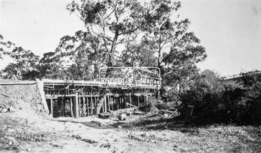
Negative - Photograph, Construction of the new concrete bridge over the Diamond Creek on Main Road, Eltham, c.May 1926
Construction of the new concrete bridge over the Diamond Creek on Main Road, Eltham, c.May 1926. Viewed from present day Wingrove Park. The original long suspension bridge over the Diamond Creek on Main Road at Eltham collapsed during flooding of the Diamond Creek on October 13 and 14, 1923. The original bridge was built around 1840 for the coach road when Cobb & Co.'s coach was the only conveyance between Eltham and Melbourne. Widespread damage was done in Melbourne and surrounding areas by floods resulting from the overflow of the Yarra at many points along its banks. A temporary bridge rigged up was severely damaged by the flooding of the creek and was closed to vehicular traffic in April 1924. A new concrete bridge was constructed to replace it and by May 1926 all the concrete piles and abutments had been completed. The bridge was finally completed and opened for traffic in September 1926, almost three years after it initially collapsed.This photo forms part of a collection of photographs gathered by the Shire of Eltham for their centenary project book,"Pioneers and Painters: 100 years of the Shire of Eltham" by Alan Marshall (1971). The collection of over 500 images is held in partnership between Eltham District Historical Society and Yarra Plenty Regional Library (Eltham Library) and is now formally known as the 'The Shire of Eltham Pioneers Photograph Collection.' It is significant in being the first community sourced collection representing the places and people of the Shire's first one hundred years.Digital image 4 x 5 inch B&W Neg Print 9 x 12.5 cmshire of eltham pioneers photograph collection, eltham, eltham lower park, main road bridge, eltham south, bridge, diamond creek (creek), wingrove park, bridge construction -
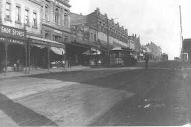
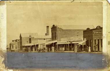 Charlton Golden Grains Museum Inc
Photograph, Charlton High Street c.1883
Photograph of western end of High Street, Charlton showing the Bank of Victoria, Malcolm's Flour Mill, Egan's, Golden Fleece Hotel, Johnson's Bridge Store, Dining Rooms and the Bank of New South Wales. c. 1883Early photo of High St, western end streetscapeSepia photograph of western end of High Street, Charlton showing the Bank of Victoria, Malcolm's Flour Mill, Egan's, Golden Fleece Hotel, Johnson's Bridge Store, Dining Rooms and the Bank of New South Wales. c. 1883. Man standing in front of the Bank, two ladies also standing on the footpath. Horse and cart in front of Johnson's store. Damage to the lower third of photo.bank of victoria, charlton, high st, malcolm's flour mill, egan's, golden fleece hotel, johnson's bridge store, dining rooms, bank of new south wales