Showing 8305 items matching " blocks"
-
 University of Melbourne, Burnley Campus Archives
Plan, Student Amenities Block 1:200, 1990-2000
Student Amenities Block - Ground Floor and First Floor plan and enlargement of SAB 3 Student Lounge (print and tracing). Refer to Fire Detection System.amenities, vcah, burnley -
Glenelg Shire Council Cultural Collection
Plan - Plans / Line Drawings - Port of Portland Authority Slipway Bilge Blocks, Wooden Vessel, Jane Kerr, victoria, 12/10/1982
PORT OF PORTLAND AUTHORITYFront: '8' - black texta, top right corner -
Glenelg Shire Council Cultural Collection
Plan - Plan / Line Drawing Port of Portland Slipway Bilge Blocks, Tug 'Kiama', 05/07/1987
Front: - black texta, top right cornerport of portland -
Linton and District Historical Society Inc
Plan, Floor plan of Railway Hotel, Linton, undated
It is not known when the plan was drawn up or by whom.Laminated blueprint, showing 1/8 scale floor and block plan of the Railway Hotel in Sussex Street, Linton. Drawn in white ink on blue paper.railway hotel linton, maps and plans, floor plans -
Canterbury History Group
Photograph - Street view of the Bryson Road side of shop No. 92 Maling Road, Jan Pigot, 1994
Coloured photograph of the street view of the Bryson Road side of Buckley's Supermarket, shop No. 92 Maling Road. This is also the corner of the building named The Block 1907.canterbury, maling road, shops, bryson street, buckley family, the block -
Lakes Entrance Historical Society
Plaque - Plaque on Red Gum block from Johnsonville School
Carved by Mick HugginsRed Gum block, carved from original stump under Johnsonville Primary School building, metal plaque centrally attached with 4 lines of inscriptionhandcrafts, woodcarving -
 Marysville & District Historical Society
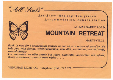
Ephemera (item) - Advertisement, MOUNTAIN RETREAT MARYSVILLE, Unknown
An advertisement for Mountain Retreat near Marysville.An advertisement for Mountain Retreat near Marysville....from Paradise Art Village, 114 Mt Margaret Rd./ Bought from "Angela" in 1985 by the/ Dowling family./ Was an artist's commune from/ about 1968-1985./ Before that was a chicken farm/ owned by the Edwards. (Parents of Betty/ Argent who lived on a 1/2 acre block just/ off from the main block with her husband,/ Charlie Argent.)marysville, victoria, australia, mountain retreat, betty argent, charlie argent, venusian light co, paradise art village, dowling family, advertisement -
 Eltham District Historical Society Inc
Photograph - Colour Print, Doug Orford, Old gaol at Pleasant Creek, Stawell Historical Society, c.1990
Reference for original bluestone cell block at Eltham Courthousecells, lockup, pleasant creek, stawell historical society -
 Eltham District Historical Society Inc
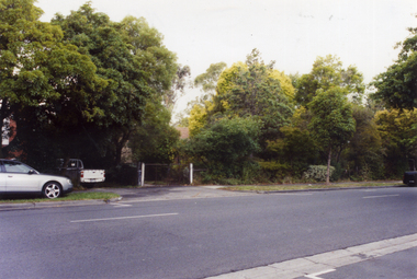
Photograph, George Coop, A day in Melbourne, northwest corner, Mont Albert and Balwyn roads, November 1962, 1962
Modern building now on vacant block of land in frontDigital TIFF file Scan of 35mm Ilford FP3 black and white transparencybalwyn road, houses, melbourne, mont albert road -
 Stawell Historical Society Inc
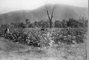
Photograph, "Murphys Block" farm in Pomonal -- growing Tobacco c1930's
Tobacco Growing - Pomonal 1930’s Murphys Blockstawell -
 National Wool Museum
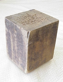
Block
Block used for cutting out square samples of cloth.textile dressings, collins bros mill pty ltd -
 Whitehorse Historical Society Inc.
Photograph, Home of Nellie Williams, 2006
Property adjoins Mitcham Private Hospital and is on a large block.Coloured photo of no. 19 Doncaster Road, Mitcham, the residence of Nellie Williams, long time resident of Mitcham. House obscured by tree, vehicle to left of photo.doncaster east road, mitcham, no 19, williams nellie -
Lakes Entrance Historical Society
Artwork, other - Lithographic Plate/Bulmer
Metal plate is mounted on wooden block and is oval in shapeLithographic plate, The Rev John Bulmer, Missionertrades, printing -
 Warrnambool and District Historical Society Inc.
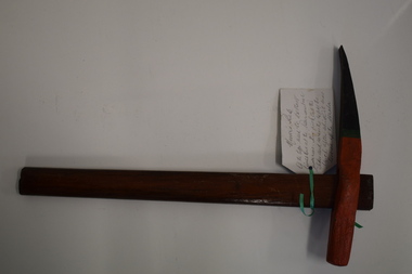
Tool, Miner's Pick
This miner’s pick was of the type used to extract limestone at the Warrnambool limestone quarries, mainly for buildings and walls. This pick cut the sides and across the top of the block and then the block was levered off the strata using a crowbar at an angle of 30° or 40°. These blocks were then reduced to the required size using cross-cut saws. There were about 12 limestone quarries operating in Warrnambool in the 19th century and limestone was extensively quarried for about 85 years to the 1930s when the quarrying ceased. Today there has been a small revival in the use of limestone blocks for building. Warrnambool also once had several bluestone quarries on the outskirts of the town. This miner’s pick is of considerable interest as an example of the type used in quarrying limestone in Warrnambool . Quarrying was once an important industry in Warrnambool. This miner’s pick has a short wooden handle with a metal stud inserted at the bottom end. The handle is rounded on the sides and tapers slightly from the top to the bottom. The metal pick has a curved shape with one blunt end and one sharp end. It has a cavity in the end nearest the blunt end and the wooden handle slots into this. The pick is painted black, green and orange, perhaps for display purposes. A handwritten information tag is attached to the handle. quarrying in warrnambool, limestone quarries in warrnambool -
 Bendigo Military Museum
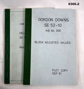
Administrative record - Report on the Block Adjustment of the Gordon Downs and Delemere 1:250,000 Maps, Army Survey Regiment, 1 Sep 1991, .2 Jan 1988
All mapping produced at this time were produced using Aerial Photography. These booklets contain the adjusted mathematical solution to joining this group of photographs together..1 Blue covered booklet with green tape binding. Block adjusted values for Gordon Downs SE 52-10 1:250 000 map Adjustment number 309 Sep 1991 .2 Blue covered booklet with green tape binding. Block adjusted values for Delamere SD 52-16 1:250 000 map Adjustment number 272 Jan 1988royal australian survey corps, rasvy, fortuna, army survey regiment, army svy regt, asr -
Port Melbourne Historical & Preservation Society
Plan - Subdivision of area bounded by Nott Street, Rouse Street, Beach Street, Port Melbourne, Block Number 2067, 1884
Copy of plan of area bordered by Nott Street, Rouse Street, Beach Street, showing subdivision of land with relevant property owners (HB DONALDSON, J NOLAN, J Hill and Sons, GW ROBINS, Carl ECKBURG, JM SMITHSON, J WALLACE) Block number 1, Port Melbourne 1884, Block number 20.67. Water Mark on Paper "J Whatman 1883"built environment - domestic, j whatman, henry beveridge donaldson, j nolan, j hill and sons, g w robins, carl eckburg, j m smithson, j wallace -
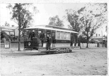 Ballarat Tramway Museum
Photograph - Block Mounted Photograph, c1903
Black and white block mounted photograph of a Bendigo ESCo two window saloon tram soon after the opening the system in 1903. Shows the driver and conductor and another person on the front saloon portion of the tram. No number can been seen. Block mounting, off white cardboard, has thick outer border of stippled cardboard with rounded corners and a white paper mounting for the photograph. trams, tramways, esco, tram crews, bendigo -
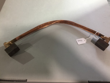 Ballarat Tramway Museum
Functional object - Traction Return Current Rail Bond, c2022
Showing how tramway electrical current was returned to the electrical sub-station via the rails.Demonstrates an earth return bonding piece.Traction Return Current Rail Bond, consists of a multi strand copper cable abt 19mm dia. and 530mm long, with block of steel (25x25x43mm) brazed onto each end. The block of steel gets welded to the outside of the rail head at or near a joint in the rails. The bond is to ensure a reliable return current as the fishplates and bolts are subject to dirt and rust which can inhibit the current.tramways, electrical engineering, earth return, bonds, trackworks -
 Bayside Gallery - Bayside City Council Art & Heritage Collection
Map, Department of Crown Lands and Survey, Moorabbin, County of Bourke, c. 1918
The cadastral map of the Parish of Moorabbin in Victoria (L.6104) shows parish boundaries and land ownership c. 1918 when Sandringham was a Borough.moorabbin, county of bourke, map, plan, land subdivision, land titles, foreshores, sndringham, hampton, beaumaris, highett, cheltenham, department of lands and survey, land owners, cartographic material, borough of sandringham, brighton -
 Kew Historical Society Inc
Photograph - 'Carronbank', Marshall Avenue, 1980s
Carronbank (demolished) in Marshall Avenue, Kew was once the home of the Rev Graham Henty Balfour. It had extensive grounds, including a tennis court at the rear of the property. It remained a private residence until c.1960. The Department of Education purchased Carronbank as a school for partially sighted children, opening in February 1961 as State School No 4483. During the period 1961 to c.1980, the building housed a number of services. From 1969 to 1974, it was the site of Carronbank State School, later renamed Carronbank School for Deaf-Blind Children. In 1973, the Department established the Visiting Teacher Service for the Visually Impaired at the site. Its aim was to support teachers working in Victorian Government, Catholic and Independent Schools. From 1983 the school operated as Statewide Resource Centre for Visiting Teachers of the Vision Impaired. In 1988, the amalgamation of Princess Elizabeth Junior School for Deaf Children, the Monnington Centre and Carronbank School for Deaf Blind Students allowed the Victorian Government to sell each of the sites. Monnington [Adeney Avenue, Kew] reverted to private ownership, while Glendonald and Carronbank in Marshall Avenue were demolished and subdivided.The donor, Mr Murray Osler, was Principal of the Monnington Special Education Centre in Adeney Avenue (Kew) from 1976. This photo, and an accompanying drawing of 'Monnington' are important primary resources for the delivery of education to and for deaf-blind children in Victoria.The photograph, framed under perspex, shows the tennis court of Carronbank which had been converted into a play area for the students of the school. The flat roofed building may have been a toilet block, added for the school. The garage brick wall belongs to No 11. Grass is growing on the original asphalt court and there is equipment and tunnels for play. When sold the property was divided into three separate building blocks.carronbank -- marshall avenue -- kew (vic.), schools -- kew (vic.), carronbank -
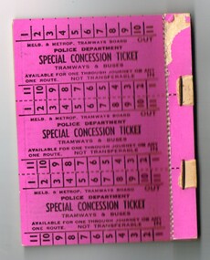 Melbourne Tram Museum
Ephemera - Ticket/s, Melbourne & Metropolitan Tramways Board (MMTB), "Police Department Special Concession Ticket", mid 1970's?
Set of 12 "Police Department Special Concession Ticket", stapled in sheets of 3, on 4 separate sheets, printed on pink card to off white cardboard. Tickets have availability for any one through journey on any one route. Not numbered. Has on the rear of the ticket blocks, the conditions of use - does not have the required cover with the Member's name. Has the remnants of the cover on the top of the block.trams, tramways, mmtb, tickets, city section, melbourne, police -
Glen Eira Historical Society
Photograph - Frogmore
This folder is about the subdivision of 'Frogmore':A black and white photograph (140mm x 90mm) of a real estate advertisement for the sale of housing blocks on the residential development Frogmore Estate, Murrumbeena. The advertisement includes a plan showing the location of the housing blocks and the surrounding roads.murrumbeena, carnegie, frogmore estate, neerim road, gnarwyn road, coorigil road, moonya road, woornack road, rosstown railway, carool road, warina road, murrumbeena road, frogmore road, wahgoo road, hethersett grove, hethersett, thomas j g, plans, housing estates, rosstown, caulfield council, land subdivision -
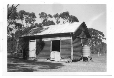 Tarnagulla History Archive
Photograph of former Tarnagulla Police Stable, Former Tarnagulla Police Stable, Mid 20th Century
Murray Comrie Collection. The town block where this stable was located was the base for policing in Tarnagulla from 1878 until the 1990s. The block was bounded by Stanley, Victoria, Wood and Gladstone Streets. The stable was built in 1886. An image of the stable in 1924 is THA-2019.0031. Monochrome photograph of a stable which once housed police horses in Tarnagulla. Dark red or brown weatherboard with white doors. tarnagulla, police, policing, horses, buildings -
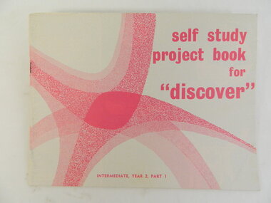 Kiewa Valley Historical Society
Book - Religious Education, Self Study Project book for 'discover' x2, 1972
Students attended Sunday School classes at the Kergunyah Presbyterian Church. Sunday school was held in a little 16 foot square wooden building which came from Rocky Valley after it was no longer needed there. Ewen Wallace's father initiated and organised the move. C2011 the building was knocked down because of white ants. The Presbyterian Church will be 125 years old in 2015.Historical: Religious Education: This book was used by students who attended the Sunday School classes at Kergunyah Presbyterian Church. Religion: Presbyterian Church at Kergunyah, in the Kiewa Valley, celebrates its 125th anniversary in 2015 after being handed over to the Uniting Church in the 1970s.White light cardboard cover with pink abstract picture and pink block print 'title'. Student book. Intermediate, Year 2, Part 1. 28 pagesreligion, christian, religious education, presbyterian, methodist, churches of christ, congregational church, anglican, kergunyah, ewen wallace, sunday school -
Federation University Historical Collection
Newsletter - Enterprise Connections, Newsletter of the School of Mines and Industries Ballarat - Enterprise Connections 3 - May 1997, 1997
School of Mines and Industries Ballarat is a predecessor of Federation University White A4 newsletter with green stripe down the left hand side with green and white writing and sepia images, also has blocks of green and brown throughoutenterprise connections, school of mines ballarat, newsletter, castle bacon, burton, gason, rotork, mars, plexicor, country fire authority -
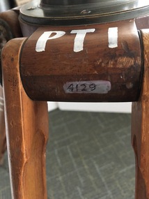 Federation University Historical Collection
Instrument - Scientific Instruments, W.& L.E. Gurley, Collapsible Leg Surveying Instrument: Tripod
Used with the Plane Table - Item 4130, in surveying classes at Ballarat School of Mines. Item 4127, Tripod Location Chains, may also have been used.A large tripod of timber construction. Concave top mount flange to receive matching spherical spigot. Spacer block halfway up each twin-strut leg.In white paint on the top "PTI" Manufacturer's stamp on each leg - circular. "W.& L.E. GURLEYtripod, surveying, scientific instrument, ballarat school of mines, plane table, location chains, w & l e gurley -
Glenelg Shire Council Cultural Collection
Photograph - Photograph - Main Breakwater construction, Portland, n.d
Port of Portland Authority Archivesport of portland archives, main breakwater, construction, harbour development -
Port Melbourne Historical & Preservation Society
Plan - Fencing and gate, Borough of Port Melbourne, Arthur Victor Heath, Town Surveyor, 27 Jul 1888
Borough of Port Melbourne, 1888 design of fencing and wicket gate for block 52 (bounded by Liardet, Esplanade East and Pickles Streets, and, originally, arm of the Sandridge Lagoon).Signed by John Inglis, James McFarlane, Marcus Erling and witnessed by E.C. Crockford; embossed with seal of Borough (PM):Pencilled "A" top right:John Inglis began a signature bottom left then changed his mind ("Jo")engineering - fences, engineering department - borough of port melbourne, arthur victor heath, marcus earling, edward c crockford, town clerks, john inglis, james mcfarlane -
Coal Creek Community Park & Museum
Music Book, The Australian Music Books no. 60
Paper back music book.Titled The Australian Music Books Number 60 Piano book/ Salon Album by Allan and Co LTD The Block Collins Street Melbourne. -
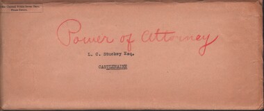 Bendigo Historical Society Inc.
Document - MCCOLL, RANKIN AND STANISTREET COLLECTION: QUARTZ BLOCK MINE - L. C. STUCKEY, 1939
Documents: bundle of documents - Power of attorney 1939, handwritten notes re: farming, insurance Policy for Quartz Block Mine, Gold Mining Lease No, 8365 Castlemaine.MCCOLL RANKIN AND STANSISTREETorganization, business, gold mining - legal, mccoll rankin and stansistreet, quartz block mine.