Showing 1961 items matching "blanche-groves"
-
 Ballarat Heritage Services
Photograph, Celebrating the refurbishment of the Williams Cottage, 3 Charles Anderson Grove, Ballarat, 01/01/2006
Members of the Williams family, the Old Colonists' Association Council, the Old Colonists' Club and friends celebrate the succesful refurbishment of the Williams Cottage at the Old Colonists' Association returement village at Charles Anderson Grove, Ballarat. Left to right: Ray Barber, Jo Barber (OCA), Stephen , Rick. Vince Braybrook (OCA), Andrew Robson (OCA), Andrew Tweedie, Gerald Jenzen, ... Williams, Travis Hurst (OCA), Melville Charles, Anne Williams, Maree (OCC),. , Judy (OCC), Margaret Knez (OCC), Rosalie, Juliette Taranto, ? , Tim (OCC), Clare Gervasoni (OCA). Keft tray barber, andrew tweedie, gerald jenzen, melville charles, anne williams, juliette taranto, ?, clare gervasoni, jo barber, vince braybrook, andrew robson, travis hurst, margaret knez -
 Ballarat Heritage Services
Photograph, Anne Williams at the Williams Cottage on the occassion of its refurbishement, 01/01/2006
Members of the Williams family, the Old Colonists' Association Council, the Old Colonists' Club and friends celebrate the succesful refurbishment of the Williams Cottage at the Old Colonists' Association returement village at Charles Anderson Grove, Ballarat. Left to right: Ray Barber, Jo Barber (OCA), Stephen , Rick. Vince Braybrook (OCA), Andrew Robson (OCA), Andrew Tweedie, Gerald Jenzen, ... Williams, Travis Hurst (OCA), Melville Charles, Anne Williams, Maree (OCC),. , Judy (OCC), Margaret Knez (OCC), Rosalie, Juliette Taranto, ? , Tim (OCC), Clare Gervasoni (OCA). Keft tray barber, andrew tweedie, gerald jenzen, melville charles, anne williams, juliette taranto, ?, clare gervasoni, jo barber, vince braybrook, andrew robson, travis hurst, margaret knez -
Glen Eira Historical Society
Article - Athole, Poplar Grove, 18, Carnegie
Two items about this property: 1/Pages 17 and 18 of the Real Estate section of the Caulfield Southern Cross 29/07/1992 including an article on Athole, Poplar Grove, 18, Carnegie, with a sketch of the house and a detained architectural description about its historic features. It also gives a brief history of the house and the life of its designer and owner, architect John T. Kelleher. Names and contact numbers of the Real Estate auctioneers are provided and there are a number of advertisements for other houses in Glen Eira. 2/A photocopy of 2 colour photographs of the exterior and garden of 'Athole' circa 2012.carnegie, poplar grove, athole, kelleher john t, biggin and scott, auctions, stables, stockdale and leggo, glen huntly, wattle avenue, munro avenue, edgewood street, brick houses, glen huntly road, glenhuntly road, j r buxton, caulfield south, pyne street, elsternwick, stanley street, noel jones and associates, brukarz jack, fitch karl, moonya road, wattle avenue, mcpherson street, timber houses, caulfield north, aroona road, dunbar avenue, urandaline grove, lascelles street, mclaurin road, trevelyan street -
 Brighton Historical Society
Badge, School badge, circa 1900s
This Shirley College school badge belonged to Gladys Elvira Linton, nee Richardson (b. 1891). Shirley College was a private girls' school situated in a large single-storey house in Seymour Grove, Brighton from around 1898 until 1912. The school was first run by the Misses Bird and later by Miss Elizabeth Stewart. Gladys married First World War veteran and Brighton local Richard Vivers Linton in 1919. She looked back fondly on her days at Shirley College and helped to organise school reunions well into the 1930s, long after the school itself was gone.Metal Shirley College school badge in the shape of a hollow crest containing the interlocking letters "S" and "C". The back has a hook rather than a proper clasp; possibly it was originally attached to a school hat.Motto engraved around border: "NISI DOMINUS FRUSTRA" (Latin, "without God, [it is] in vain").shirley college, schools, school uniform, 1900s, gladys elvira linton, gladys elvira richardson -
 Eltham District Historical Society Inc
Photograph, Frank Stokes with daughters Dorothy (left) and Beryl (right) at Stokes Orchard, Nyora Road, Eltham, 1944, 1944
Frank Stokes first traveled to the district by train in 1944 to find land with the intention to establish an orchard. By chance he met Arthur Bird of Bird Orchard (bounded by Pitt Street, Eucalyptus Road and Wattle Grove) and they got talking over their common interest. Arthur put Frank up for the night and pointed out the land, part of Crown Allotment 15, Section 5, Parish of Nillumbik (CA15) somewhat diagonally opposite Bird Orchard. Frank bought the land and for the next two years would travel by train from Melbourne to Eltham every weekend establishing Stokes Orchard and building a home for his family, which they eventually moved into in 1946. In the mid 1970s the Shire of Eltham divided the orchard up into numerous rate-able parcel lots, which became affordable for Frank. As a consequence Stokes Orchard was turned into a housing development by Macquarie Builders and marketed as the Stokes Orchard Estate in two stages; Stage 1 encompassing Scarlet Ash Court, Ironbark Close and Peppermint Grove bounded by Nyora and Eucalyptus roads c.1976 and Stage 2 encompassing Stokes Place, Orchard Way, The Crest and The Lookout bound by Nyora and Diosma roads c.1979. The development of Orchard Way, The Crest and The Lookout did not proceed as planned due to the lack of the sewer along Diosma Road and so many of the proposed lots were incorporated into five-acre parcels instead.Representative of the orchard growing areas of ElthamDigital file only - Digitised by EDHS from a scrapbook (containing commercially printed photos of digital scans) on loan from Beryl Bradbury (nee Stokes), daughter of Frank Stokes.1944, beryl bradbury (nee stokes), beryl bradbury (nee stokes) collection, dorothy stokes, eltham, frank stokes, nyora road, stokes orchard -
 Ringwood and District Historical Society
Flyer, Land Sale Auction Brochure, Electric Railway Estate, Ringwood, Vic. - 1922
Bi-folded single sheet with black and red print both sides advertising auction of allotments on Saturday, November 18, 1922, including details of subdivision features and local facilities. Subdivision includes Bedford Road, Williams Grove, Campbell Street, Myrtle Avenue, George Street, and Henry Street. Agents - F.H. Patterson & Co., 19 Queen Street, Melbourne, Tel. 4308 Central, J.B. McAlpin, Opposite Railway Station, Ringwood, Tel 7 Ringwood, SYDNEY T. Haynes & Co., Auctioneer, 60 Queen Street, Melbourne, Tel 3400 Central. -
 Ringwood and District Historical Society
Document, Certificate of Title - W.G. Carter, Grandview Grove, Warranwood, Victoria, (later Bemboka Road) - part of Crown Section Twenty, Parish of Warrandyte, County of Evelyn - 1947
A4 copies of Landata Victoria Historical Search documents - Vol 7052 Fol 1410222. Includes Carter Family Tree property notes. William George Carter of Grandview Grove Ringwood, Nurseryman, is now the proprietor - three acres or thereabouts shown on map (12202a) - 14th March, 1947. Transfer B284834 Registered 21 September, 1961 - 1 acre shown on map (12202c) north of Plymouth Road. NOTES ON GRANDVIEW GROVE PROPERTY (Carter Family Tree extract) The Grandview Grove property was purchased by William (Bill) and Doreen Carter in 1947 as three acres of uncleared bushland. They had a 2 bedroom fibro-cement house built on the land which they informally called "Willoreen". With Doreen looking after sons Peter (born in 1940) and Robin (born in 1950), Bill worked locally at Croydon Dairy. The family spent much of their spare time clearing the land, where Bill then grew and sold fruit, flowers and berries, particularly strawberries, as a hobby and to supplement their income. Bill continued to do so while Peter and Robin were growing up, and after Doreen died in 1958. In 1961 Bill sold one of the three acres to one of his seven sisters, Grace, who lived in Kew but later moved to Rosebud and sold the land without ever building on it. During the 1960s, Grandview Grove was renamed Bemboka Road. After retiring as a milkman, Bill moved to Rosebud, Vic, and in 1977, sold the property to the Anglican Church, who were looking to invest in the site in anticipation of proposed future residential development in the area. As nearby properties were subdivided during the 1980s, the house, which the Church had initially utilised as low-cost family accommodation, was modified internaly to become a church/Sunday school. By the early 2000s, construction of a contemporary-design church and carparking area between the house and street alignment had been completed but the house remained as a detatched meeting room until falling into disrepair and was eventually demolished around 2010. -
 Eltham District Historical Society Inc
Photograph - Aerial Photograph, Landata, Eltham, Vic, Apr. 1963
Centred on present day John Street, Eltham between Main and Bible streets bounded by Elsa Court to north, Main Road Bridge to south, Wattle Grove to east and Bolton Street to west. Historic Aerial Imagery Source: Landata.vic.gov.au Aerial Photo Details: Project No :486 Project : MELBOURNE (1963) PROJECT Run : 6 Frame : 123 Date : 04/1963 Film Type : B/W Camera : RC8 Flying Height : 5100 Scale : 9600 Film Number : 1805 GDA2020 : 37°43'12"S, 145°08'54"E MGA2020 : 336800, 5823623 (55) Melways : 21 J6 (ed. 42)aerial photo, neil webster collection, 1963-04, bolton steet, elsa court, eltham, john street, main road, main road bridge, melway 21j6, wattle grove -
 Kew Historical Society Inc
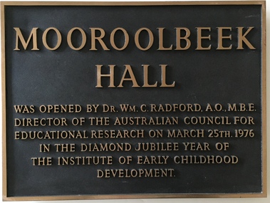
Plaque, Institute of Early Childhood Development, Mooroolbeek Hall, 1976
The Free Kindergarten Union of Victoria commenced teacher training in 1909. A two year course was run in cooperation with the Education Department in 1910-14, but from 1917 the Union trained its students independently. In 1922 the Kindergarten Training College was established in Mooroolbeek, Kew. In 1965, the institution, as the Melbourne Kindergarten Teachers' College, became an entity separate from the Union, and in 1973 joined the State College of Victoria as the Institute of Early Childhood Development. It subsequently amalgamated with the University of Melbourne to become the Department of Early Childhood Studies and moved from Madden Grove, Kew, to 234 Queensberry St, Carlton, early in July 1997.Metal plaque commemorating the opening of Mooroolbeek Hall in the Diamond Jubilee Year of the Institute of Early Childhood Development in KewMooroolbeek Hall was opened by Dr Wm C. Radford, AO, MBE, Director of the Australian Council for Educational Research on March 25th 1976 in the Diamond Jubilee Year of the Institute for Early Childhood Developmentinstitute of early childhood development - kew (vic), dr william c. radford, memorial plaques - kew (vic), mooroolbeek hall -
 Kew Historical Society Inc
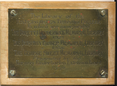
Plaque - Commemorative Plaque, Institute of Early Childhood Development, Opening of the Library of the Kindergarten Training College, Kew, 1950, 1950
The Free Kindergarten Union of Victoria commenced teacher training in 1909. A two year course was run in cooperation with the Education Department in 1910-14, but from 1917 the Union trained its students independently. In 1922 the Kindergarten Training College was established in Mooroolbeek, Kew. In 1965, the institution, as the Melbourne Kindergarten Teachers' College, became an entity separate from the Union, and in 1973 joined the State College of Victoria as the Institute of Early Childhood Development. It subsequently amalgamated with the University of Melbourne to become the Department of Early Childhood Studies and moved from Madden Grove, Kew, to 234 Queensberry St, Carlton, early in July 1997.Small brass plaque mounted on wood commemorating the libraries of the Kindergarten Training College in Kew.The library of the Kindergarten Training College in which are incorporated the Doretta Hedderwick Memorial 1927, the Dorothy Rosner Memorial 1936, the George Sweet Memorial Library - Presented by the Nursery Kindergarten Exrension Board 1950institute of early childhood development - kew (vic), libraries - education - early childhood - kew (vic), doretta hedderwick memorial library 1927, dorothy rosner memorial library 1936, george sweet memorial library, nursery kindergarten exrension board -
 Kew Historical Society Inc
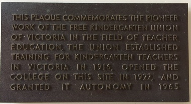
Plaque - Commemorative Plaque, Free Kindergarten Union of Victoria, Commemoration of the Free Kindergarten Union of Victoria, circa 1965, c.1965
The Free Kindergarten Union of Victoria commenced teacher training in 1909. A two year course was run in cooperation with the Education Department in 1910-14, but from 1917 the Union trained its students independently. In 1922 the Kindergarten Training College was established in Mooroolbeek, Kew. In 1965, the institution, as the Melbourne Kindergarten Teachers' College, became an entity separate from the Union, and in 1973 joined the State College of Victoria as the Institute of Early Childhood Development. It subsequently amalgamated with the University of Melbourne to become the Department of Early Childhood Studies and moved from Madden Grove, Kew, to 234 Queensberry St, Carlton, early in July 1997.Plaque recognising the site of an important educational institution for teacher training.Bronze plaque with raised lettering commemorating the role of the Free Kindergarten Union of Victoria which had opened in 1916"This plaque commemorates the pioneer work of the Free Kindergarten Union of Victoria in the field of teacher education, the Union established training for kindergarten teachers in Victoria in 1916, opened the college on this site in 1922, and granted it autonomy on 1965."institute of early childhood development - kew (vic), free kindergarten union of victoria, early childhood education - kew - victoria -
 Kew Historical Society Inc
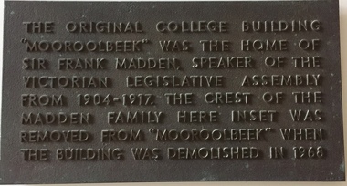
Plaque - Commemorative Plaque, Institute of Early Childhood Development, 'Mooroolbeek', Madden Grove, Kew, c.1968
The Free Kindergarten Union of Victoria commenced teacher training in 1909. A two year course was run in cooperation with the Education Department in 1910-14, but from 1917 the Union trained its students independently. In 1922 the Kindergarten Training College was established in Mooroolbeek, Kew. In 1965, the institution, as the Melbourne Kindergarten Teachers' College, became an entity separate from the Union, and in 1973 joined the State College of Victoria as the Institute of Early Childhood Development. It subsequently amalgamated with the University of Melbourne to become the Department of Early Childhood Studies and moved from Madden Grove, Kew, to 234 Queensberry St, Carlton, early in July 1997.Commemorative plaque indicating the location of a former Kew mansionBronze plaque commemorating the location of Mooroolbeek, one of the great mansions of Kew, demolished in 1968 by the Kindergarten Training College"The original college building "Mooroolbeek" was the home of Sir Frank Madden Speaker of the Victorian Legislative Assembly from 1904-1917. The crest of the Madden family here inset was removed from "Mooroolbeek" when the building was demolished in 1968."institute of early childhood development - kew (vic), mooroolbeek - madden grove - kew (vic), sir frank madden -
 Kew Historical Society Inc
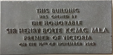
Plaque - Commemorative Plaque, Institute of Early Childhood Development, This building was opened by the Honorable Sir Henry Bolte KCMG MLA, Premier of Victoria, on the 10th December 1969, 1969
The Free Kindergarten Union of Victoria commenced teacher training in 1909. A two year course was run in cooperation with the Education Department in 1910-14, but from 1917 the Union trained its students independently. In 1922 the Kindergarten Training College was established in Mooroolbeek, Kew. In 1965, the institution, as the Melbourne Kindergarten Teachers' College, became an entity separate from the Union, and in 1973 joined the State College of Victoria as the Institute of Early Childhood Development. It subsequently amalgamated with the University of Melbourne to become the Department of Early Childhood Studies and moved from Madden Grove, Kew, to 234 Queensberry St, Carlton, early in July 1997.Metal alloy plaque commemorating the opening of a building by the Premier of Victoria, Sir Henry Bolte, on 10th December 1969This building was opened by the Honorable Sir Henry Bolte KCMG MLA, Premier of Victoria, on the 10th December 1969sir henry bolte, commemorative plaques - kew (vic), institute of early childhood development -
 Kew Historical Society Inc
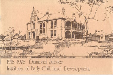
Booklet, Institute of Early Childhood Development, 1916-1976 Diamond Jubilee, 1976
The Free Kindergarten Union of Victoria commenced teacher training in 1909. A two year course was run in cooperation with the Education Department in 1910-14, but from 1917 the Union trained its students independently. In 1922 the Kindergarten Training College was established in Mooroolbeek, Kew. In 1965, the institution, as the Melbourne Kindergarten Teachers' College, became an entity separate from the Union, and in 1973 joined the State College of Victoria as the Institute of Early Childhood Development. It subsequently amalgamated with the University of Melbourne to become the Department of Early Childhood Studies and moved from Madden Grove, Kew, to 234 Queensberry St, Carlton, early in July 1997.[16]p. : ill., ports. ; 19 x 28 cm. Includes photographs of the Institute, its leaders and students. Included are a chronology and a number of photos (above) of Mooroolbeek, part of the complex, which is now all demolished.institute of early childhood development, mooroolbeek -
 Kew Historical Society Inc
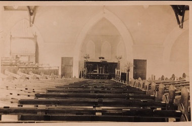
Postcard - Interior, Kew Baptist Church, 1920s
The Kew Baptist Church was originally located on the corner of Cotham Road and St John’s Parade. In 1922, work commenced on a new, larger church in Highbury Grove. The foundation stone of the new building was laid by Cr Ratten of the City of Kew on Saturday 14 October 1922, with the First Kew Scouts forming a guard of honor. A collection taken up at the laying of the foundation stone raised £454. The site and building cost approximately £6,000. The architects for this new red brick ‘semi-Gothic’ church were Messrs Gawler & Drummond. The interior of the church accommodated 500 parishioners. The seating sloped towards the pulpit with no columns obstructing the view of the worshippers. Faded sepia 'real photo' Kodak postcard of the interior and altar of Kew Baptist Church "Interior of Kew Baptist Church"kew baptist church -- highbury grove, churches -- kew (vic.), baptist churches, christian-washfold collection -
 Kew Historical Society Inc
Photograph - Willsmere [Kew] Billabong, 1993
Willsmere Park is bounded by the the Yarra River, Green Acres Golf Club, Willow Grove and the Eastern Freeway. The land on which the park is now situated was bought by Thomas Wills at the Crown Land Sales of 1846 (Section 56). From the 1840s to the 1940s it was intensively farmed. The park is dominated by very large playing fields, while planting to the southern boundary was undertaken when the Eastern Freeway was built. It is only along the banks of the Yarra that there is any remnant native vegetation. Willsmere Park is of significance as an area of open land that remains from the flood plain that once dominated northern Kew. (Source: Kew Conservation Study, 1988)Original colour small format polaroid photograph of the 'Kew Billabong' in the Willsmere Park, taken on 16 September 1993."Willsmere Billabong 16.9.93"kew billabong, willsmere park, yarra river -- billabongs -
 Kew Historical Society Inc
Photograph - Yarra River in flood at the Willsmere Park, 1993
Willsmere Park is bounded by the the Yarra River, Green Acres Golf Club, Willow Grove and the Eastern Freeway. The land on which the park is now situated was bought by Thomas Wills at the Crown Land Sales of 1846 (Section 56). From the 1840s to the 1940s it was intensively farmed. The park is dominated by very large playing fields, while planting to the southern boundary was undertaken when the Eastern Freeway was built. It is only along the banks of the Yarra that there is any remnant native vegetation. Willsmere Park is of significance as an area of open land that remains from the flood plain that once dominated northern Kew. (Source: Kew Conservation Study, 1988)Original colour small format polaroid photograph of the Yarra River in flood at the Willsmere Park, taken on 16 September 1993."Yarra River at Willsmere Park Flooding 16.9.93"willsmere park, yarra river -- floods -- kew (vic.) -
 Kew Historical Society Inc
Photograph - Flooding in the Willsmere Park, 1993
Willsmere Park is bounded by the the Yarra River, Green Acres Golf Club, Willow Grove and the Eastern Freeway. The land on which the park is now situated was bought by Thomas Wills at the Crown Land Sales of 1846 (Section 56). From the 1840s to the 1940s it was intensively farmed. The park is dominated by very large playing fields, while planting to the southern boundary was undertaken when the Eastern Freeway was built. It is only along the banks of the Yarra that there is any remnant native vegetation. Willsmere Park is of significance as an area of open land that remains from the flood plain that once dominated northern Kew. (Source: Kew Conservation Study, 1988)Original colour small format polaroid photograph of flooding in the Willsmere Park, taken on 16 September 1993."Flooding of shared path from Willsmere Billabong 16.9.93"willsmere park, yarra river -- floods -- kew (vic.), kew billabong -
 Kew Historical Society Inc
Photograph - Flooding in the Willsmere Park, 1993
Willsmere Park is bounded by the the Yarra River, Green Acres Golf Club, Willow Grove and the Eastern Freeway. The land on which the park is now situated was bought by Thomas Wills at the Crown Land Sales of 1846 (Section 56). From the 1840s to the 1940s it was intensively farmed. The park is dominated by very large playing fields, while planting to the southern boundary was undertaken when the Eastern Freeway was built. It is only along the banks of the Yarra that there is any remnant native vegetation. Willsmere Park is of significance as an area of open land that remains from the flood plain that once dominated northern Kew. (Source: Kew Conservation Study, 1988)Original colour small format polaroid photograph of flooding in the Willsmere Park, taken on 16 September 1993."Flooding of Willsmere Park from Yarra 16.9.93"willsmere park, yarra river -- floods -- kew (vic.) -
 Kew Historical Society Inc
Photograph - Flooding of Willsmere Park from Yarra, 1993
Willsmere Park is bounded by the the Yarra River, Green Acres Golf Club, Willow Grove and the Eastern Freeway. The land on which the park is now situated was bought by Thomas Wills at the Crown Land Sales of 1846 (Section 56). From the 1840s to the 1940s it was intensively farmed. The park is dominated by very large playing fields, while planting to the southern boundary was undertaken when the Eastern Freeway was built. It is only along the banks of the Yarra that there is any remnant native vegetation. Willsmere Park is of significance as an area of open land that remains from the flood plain that once dominated northern Kew. (Source: Kew Conservation Study, 1988)Original colour small format polaroid photograph of flooding in Willsmere Park resulting from heavy rain on 15 September 1993."Flooding of Willsmere Park from Yarra 16.9.93"yarra river -- floods -- kew (vic.), willsmere park -
 Kew Historical Society Inc
Photograph - Willsmere [Kew] Billabong, 1993
Willsmere Park is bounded by the the Yarra River, Green Acres Golf Club, Willow Grove and the Eastern Freeway. The land on which the park is now situated was bought by Thomas Wills at the Crown Land Sales of 1846 (Section 56). From the 1840s to the 1940s it was intensively farmed. The park is dominated by very large playing fields, while planting to the southern boundary was undertaken when the Eastern Freeway was built. It is only along the banks of the Yarra that there is any remnant native vegetation. Willsmere Park is of significance as an area of open land that remains from the flood plain that once dominated northern Kew. (Source: Kew Conservation Study, 1988)Original colour small format polaroid photograph of Willsmere [Kew] Billabong on September 1993."Willsmere Billabong 16.9.93"yarra river -- floods -- kew (vic.), willsmere park -
 Puffing Billy Railway
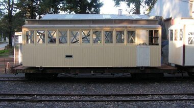
6 NB - Saloon carriage, 22/ 8/1904
NB Class - Number Built (1st Series) 6 - Number Built (2nd Series) 17 - Number Built (3rd Series) 4 6 NB - Saloon carriage (24) Body Length 20 feet 6 inches ( 6248 mm) Vehicle Length 25 feet 2 inches ( 7671 mm) Coupled Length 27 feet 4 inches (8330 mm) Width 6 feet 3 inches (1905 mm) Height 9 feet 5 inches (2870 mm) Weight 8 tons Capacity 16 passengers Built 1898 - 1904 Number Built 6 In use NB 1. NBD 2, 5 Awaiting restoration NB 6 VR Service History NBB 6.VA - 22/ 8/1904 NWS Built new - circa 1910 - To NB 6.VA - *NB 6.VA - / 4/1926 - Modified AC Malco 4/ 3/1938 - Scrapped - Puffing Billy Service History or Notes NB (first series) NB - There were three types: -Nos. 1-6 were Saloon cars having end platforms and a ladies toilet, and were built from 1899-1904. Nos. 7-23 were 5-compartment side loading cars, built from 1906-1915. Nos. 24-27 were the former NAB class cars mentioned previously and were also side loading, having 6 compartments and two ladies toilets. Rescued by the Puffing Billy Preservation Society from Ocean Grove Victorian in Nov 2010 Nov 2010 Two carriages have been rescued from Ocean Grove where they had been built into a house. They are now at Emerald, one being a platform NB carriage and the other a swing door NB carriage. Storage of these vehicles is being considered. Many people were involved in the move: thanks go to Raymond and Thelma Cotter for providing tarps to protect the cars from the elements. Dec 2010 Two carriages rescued from Ocean Grove are now at Emerald, one being a platform NB car (6NB) and the other a 2nd Class swing door carriage. Minor refurbishment has taken place along with covering with Tarpaulins.Historic - Victorian Railways Narrow Gauge - Passenger Rolling Stock: Saloon carriagePassenger Rolling Stock: Saloon carriage 6NB - Made of Timber. 6 NBpuffing billy railway, pbr, rolling stock , 6 nb, puffing billy, 6nb, saloon carriage, victorian railways, narrow gauge passenger rolling stock, 2'6" guage -
 Bendigo Historical Society Inc.
Photograph - HARRIS COLLECTION: STEREOSCOPIC VIEWS, Nineteenth Centur
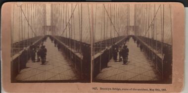
Stereoscopic views. Kilburn Brothers Littleton , N H. 1. Trinity college Dublin. 2. Brooklyn Bridge, scene of the accident , May 30th 1883. 3. Spinning Room , Mechanics Mill, Fall River Mass. 4. Bay Grove Hill, Greenwood Cemetery, Brooklyn, N Y. 5.Crossing the Great Suspension Bridge, by rail. 6. Dining Hall , Grand Union Hotel, Saratoga, Largest Dining Hall in the World. 7. Phantom Leaves. 8. Full Moon. 9. Merced River, Yo-Semite , Cal. 10. I Breathe Inspiration. 11. United States Hotel Park, Saratoga.Kilburn Brothers Littleton N H.photography, viewers -
 Bendigo Historical Society Inc.
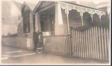
Photograph - QC BINKS COLLECTION: CLIFF BINKS IN FRONT OF MRS. KEATH'S BOARDING HOUSE
(2) Copy of original : image shows man standing on footpath leaning on gate post of house. Notation: Cliff Binks in front of Mrs. Keath's boarding house located at 270 High Street, Bendigo. Had 6 boarders. Mrs. Keath ran the very good boarding house with her daughter's help. Grenfell's two storey (residence above) butcher's shop is on far left of photo - next to Hawley's Grovers shop, now pizza hut. 1938. Note with photos 'Bruce Mainka personally paid Cliff Binks $3.30 for these unsolicited photocopies. Donated to BHS by B.G. Mainka but recorded as a purchase'person, individual, cliff binks, binks, bendigo, keath, grenfell, hawley -
 Kew Historical Society Inc
Plan - Subdivision Plan, Summerhill Estate, 1920-1940
Pru Sanderson, in her groundbreaking ‘City of Kew Urban Conservation Study : Volume 2 - Development History’ (1988), summarised the periods of urban development and subdivisions of land in Kew. The periods that she identified included 1845-1880, 1880-1893, 1893-1921, 1921-1933, 1933-1943, and Post-War Development. These periods were selected as they represented periods of rapid growth or decline in urban development. An obvious starting point for Sanderson’s groupings involved population growth and the associated economic cycles. These cycles also highlighted urban expansion onto land that was predominantly rural, although in other cases it represented the decline and breakup of large estates. A number of the plans in the Kew Historical Society’s collection can also be found in other collections, such as those of the State Library of Victoria and the Boroondara Library Service. A number are however unique to the collection.The Kew Historical Society collection includes almost 100 subdivision plans pertaining to suburbs of the City of Melbourne. Most of these are of Kew, Kew East or Studley Park, although a smaller number are plans of Camberwell, Deepdene, Balwyn and Hawthorn. It is believed that the majority of the plans were gifted to the Society by persons connected with the real estate firm - J. R. Mathers and McMillan, 136 Cotham Road, Kew. The Plans in the collection are rarely in pristine form, being working plans on which the agent would write notes and record lots sold and the prices of these. The subdivision plans are historically significant examples of the growth of urban Melbourne from the beginning of the 20th Century up until the 1980s. A number of the plans are double-sided and often include a photograph on the reverse. A number of the latter are by noted photographers such as J.E. Barnes.The Summerhill Estate was a subdivision in Glen Iris of 24 ‘choice allotments’. The lots were primarily on both sides of Dillon Grove. Other lots at each end of the subdivision faced Margaret Street and Summerhill Road. It was from the latter that the subdivision took its advertised title. The lots were originally advertised for £10 deposit with 20 subsequent payments over five years. Pencilled on the printed plan is a change to the deposit required; a reduction to 20/-. Annotations indicate that the new deposits ranged from 30/- to 45/-. The most expensive lots faced Summerhill Road. This subdivision plan is unusual in that the front and rear of the card are for subdivisions in different localities.subdivision plans - glen iris, summerhill estate -
 Bendigo Historical Society Inc.
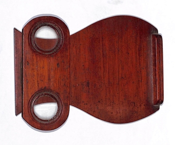
Functional object - Folding lens timber stereograph viewer
This item was in a cabin trunk that belonged to Henry Frencham which also included his Petition to Parliament and the findings from the Parliamentary enquiry into his and other claims to be the first to find gold at Bendigo. A stereoscope is a device for viewing a stereoscopic pair of separate images, depicting left-eye and right-eye views of the same scene, as a single three-dimensional image.A dark brown wooden half centimetre thick base with curved edges varying in width from eight centimetres, twelve centimetre, seven centimetres and ten centimetres. A half centimetre by half centimetre piece of wood with a grove in it is glued to one end. On the other end an oval shaped half centimetre thick, twelve centimetres long and five centimetres wide, has two three centimetre diametre glass lenses in it and is attached by a small single hinge so it can be folded against the other piece for storage or raised to right angles to look through the lenses at an image in the groove at the end of the base piece.steroscope, henry frencham -
 Bendigo Historical Society Inc.
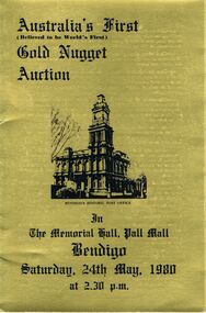
Document - IAN DYETT COLLECTION: AUCTION CATALOGUE - GOLD NUGGET AUCTION
Three gold covered auction catalogues with black printing for Australia's First (Believed to be World's First) Gold Nugget Auction held in the Memorial Hall, Pall Mall, Bendigo on the 24th May, 1980. Catalogues are made of card and are tri-fold. On the front is a black sketch of Bendigo Historic Post Office. The inside which is white are the Conditions of Sale, the centre has the List of Nuggets which includes Lot No., No. of Nuggets and Approx. Lot Wt. in Grains. Under this are the Ingots which includes the Lot No. and Approx. Weight in Grains. Some notes are underneath. On the right fold is A History of Gold Discovery in Victoria and Large Nugget finds in the Area. Also mentioned are the Welcome Stranger Nugget, The Blanche Barkly Nugget and the Robins Nugget. On the inside gold side is A History of 3 D's Gold Mine N.L. and some information about Nuggets. On the back is Curnows name and a Reproduction of Curnows original Letterhead circa 1900.business, auctioneers, j h curnow & son pty ltd, ian dyett collection - auction catalogue - gold nugget auction, 3d's gold mine n.l., bendigo advertiser & clearads, mines department, welcome stranger nugget, red hill company's mine, blanche barkly nugget, precious nugget, ah chang, desmond robins, arthur robins, mining lease 452, mr a sexauer, robins nugget, gold nugget casino las vegas, bolton bros pty ltd, bluey robins, doug cahill, dick sandner, department of minerals and energy, national bank of australasia ltd, commonwealth development bank daryl mcclure, e j dunn, department of mines, curnows (bendigo), j h curnow & son pty ltd, ian dyett, fred dyett -
 Eltham District Historical Society Inc
Photograph - Aerial Photograph, Landata, Eltham, Vic, Apr. 1963
Centred on present day Floriston Grove, Eltham bounded by Maroondah Aqueduct to north, Thompson Crescent and Diosma Road to south, Research Shops to east and Glen Park Road and Park West Road to west. Historic Aerial Imagery Source: Landata.vic.gov.au Aerial Photo Details: Project No :486 Project : MELBOURNE (1963) PROJECT Run : 5 Frame : 60 Date : 04/1963 Film Type : B/W Camera : RC8 Flying Height : 5100 Scale : 9600 Film Number : 1805 GDA2020 : 37°42'24"S, 145°09'29"E MGA2020 : 337622, 5825128 (55) Melways : 22 B3 (ed. 42)aerial photo, neil webster collection, eltham, 1963-04, diosma road, floriston grove, maroondah aqueduct, melway 22b3, park west road, research (vic.), research shops -
 Mission to Seafarers Victoria
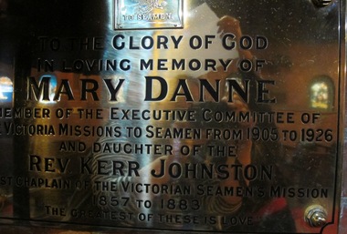
Plaque - Memorial plaque, Mary Danne, 1927
Mary was the fifth daughter of Reverend Kerr Johnston and his wife Elizabeth. Mary married Reverend Richard Vallencey Danne (1846-1904), they had 8 children. One of their son Noel also became a reverend. She continued her father's work by becoming part of the Mission's committee in 1905. On 9 November 1906, for King's Birthday, she hosted a sailors' picnic at the property she rented, Glenfern on Inkerman Road (see item 1637), where she was running a school, Newington. She died on the 30th of July 1926 at her residence, Seymour Grove in Camberwell. The plaque was erected on the 9 October 1927 (AR 1927).The Kerr Johnston Family migrated to Tasmania in 1854. The Reverend took up his appointment with the Victorian Bethel Union for Seamen in 1857 and moved all his family in the "floating church", the ex water police hulk Emily, first Chaplain serving the seamen in Hobsons' Bay.Large rectangular brass plaque with smaller plaque mounted onto it of Mission to Seamen insignia. The Larger plaque is mounted to a brick wall.Mission to Seamen. To the glory of God In loving memory of Mary Danne member of the executive committee of the Victoria Missions to Seamen from 1905 to 1920 and daughter of the REv. Kerr -Johnston chaplain of the Victorian Seamen's Mission 1857 to 1883 "The greatest of these is love"mary alice isabelle danne nee johnston, 1851-1926, reverend kerr johnston, reverend richard vallencey danne, 1846-1904, bethel, hulk emily, hobson's bay, glenfern, flinders street, st peter chapel -
 Kew Historical Society Inc
Photograph, Kew RSL, Cotham Road, circa 1965, c. 1965
The Kew RSL is located in "Wilton" House, 63 Cotham Road. The RSL was established on January 1st 1920, later joining with the Hawthorn RSL. In November 1931, Cr. C.R. Parry organised the reformation of the Kew Sub Branch and its first president was Brig-Gen Pat McGlin, a veteran of the Boer War and the First World War. On July 17th 1932, the club rooms first opened on Army land at the corner of High Street and Highbury Grove. In late November 1948, the Kew RSL bought the "Wilton" house from the Kew City Council for £10,067, opening seven years later in July 1955. [Source: Victorian Heritage Database]This work forms part of the collection assembled by the historian Dorothy Rogers, that was donated to the Kew Historical Society by her son John Rogers in 2015. The manuscripts, photographs, maps, and documents were sourced by her from both family and local collections or produced as references for her print publications. Many were directly used by Rogers in writing ‘Lovely Old Homes of Kew’ (1961) and 'A History of Kew' (1973), or the numerous articles on local history that she produced for suburban newspapers. Most of the photographs in the collection include detailed annotations in her hand. The Rogers Collection provides a comprehensive insight into the working habits of a historian in the 1960s and 1970s. Together it forms the largest privately-donated collection within the archives of the Kew Historical Society.The exterior of the Kew RSL on the corner of Cotham Road and Charles Street, Kew. Designed by Guyon Purchase for Dr. William Walsh in 1886, the building was originally called Wilton."Chap 59. Cotham Rd. Built/Commences about 1885-6. Present day Wilton . Kew RSSUILA rooms. (Rumour of sale 1972?)"wilton, dr william walsh, guyon purchas, dorothy rogers, cotham road (kew)