Showing 1110 items matching "information map"
-
 Melbourne Tram Museum
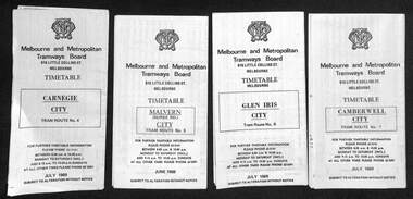
Ephemera - Set of 24, Melbourne & Metropolitan Tramways Board (MMTB), "MMTB Tram Timetables", 1969
Set of 23 timetables for specific routes, day of week giving information on tram times at specific time points, route map, sections and fares and organisation address - 616 Little Collins St. Melbourne. All July 1969. The first set of timetables issued in this format. 1- Route 4 - Carnegie - City 2 - Route 5 - Malvern (Burke Rd.) - City 3 - Route 6 - Glen Iris - City 4 - Route 7 - Camberwell - City 5 - Route 8 - Toorak - City 6 - Route 9, 10 and 12 - South Melbourne and St Kilda Beach - City 7 - Routes 10, 11, 9 and 9A - West Preston Northcote - City 8 - Route 1, 2A, 15, 16 - St Kilda Beach - South Melbourne - City 9 - Route 1, 15, 21, 22 - Moreland - East Coburg - City 10 - Route 19 - North Coburg - City 11 - Route 42 - Mont Albert - City 12 - Route 48, 74 - North Balwyn - Burwood - City 13 - ditto - Saturdays and Sundays - printed on pink paper 14 - Route 55, 56 - West Coburg - Domain Road - via William St 15 - Route 57 - West Maribyrnong - City - bus route Sundays only 16 - Route 59 - Essendon Aerodrome - City 17 - Route 64, 65 - East Brighton - via Swanston St/ William St 18 - Route 69 - Kew Cotham Road - St Kilda Beach 19 - Route 70 - Wattle Park - City 20 - Route 77, 78, 79 - Prahran - City, North Richmond - Prahran - St Kilda Beach 21 - Route 82 - Footscray - Moonee Ponds - bus route Saturday afternoon and Sundays 22 - Route 88 and Route 96 - East Preston, East Brunswick - city - July 1969, printed on white paper. - Weekdays and Sundays 23 - Route 88, 96 - East Preston and East Brunswick (Blyth St)< Saturdays, Xmas day and Good Fri - printed on pink paper. 24 - Route 4D - East Malvern (Darling Road) - City, bus route Sundays only Yields information about MMTB Tram services during 1969Set of 24 MMTB Tram timetables, folded sheets.trams, tramways, mmtb, timetables, melbourne, fares, route 69, route 64, route 88, route 96, route 4, route 4d, route 5, route 6, route 7, route 8, route 9, route 9a, route 10, route 11, route 12, route 1, route 15, route 21, route 22, route 2a, route 15, route 16, route 19, route 42, route 48, route 74, route 55, route 56, route 57, route 59, route 65, route 70, route 77, route 78, route 79, route 82 -
 Melbourne Tram Museum
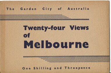
Book, Victorian Government Information Bureau?, "The Garden City of Australia / Twenty-four views of Melbourne", c1950
Book, brown cover patterned (Deer skin?), titled "The Garden City of Australia / Twenty-four views of Melbourne" with 24 pages (smaller than cover) printed pages stapled inside. Inside front cover is a map of Melbourne, with specific buildings marked, inside rear cover - Where to go in Melbourne, General Information and Sight seeing tours. On rear cover is printer details. Page Photo details by 1 Skyline of the City of Melbourne from Yarra Bank Victorian Railways 2 Collins St from Spring St (with trams) ditto 3 Princes Bridge, River Yarra ditto 4 St Kilda Rd from Flinders St Station ditto 5 St Pauls Cathedral ditto 6 Bourke St Shopping Centre - with double deck buses no details of photographer 7 Elizabeth St - with trams and buses Victorian Railways 8 Swanston St with modern skyscrapers (Collins) ditto 9 Aerial view, city of Melbourne ditto 10 Parliament House ditto 11 Public Library, Museum and Art Gallery ditto 12 St Kilda Rd, Looking towards the City trams 772 and W2 ditto 13 Kings Domain - Pioneer Monument ditto 14 Royal Melbourne Hospital - with back view inset ditto 15 Alexandra Gardens and the Shrine of Remembrance ditto 16 Alexandra Gardens and Government House ditto 17 Captain Cook's House - Fitzroy Gardens ditto 18 Albert Park Lake no details of photographer 19 Melbourne Boys School, MacRobertson's Girls High School and Melbourne Uni - no details of photographer 20 Scene in the Botanical Gardens Victorian Railways 21 Aerial view of St Kilda with Brighton in background Victorian Railways 22 Melbourne Cricket ground, taken during the testimonial match to Sir Donald Bradman - no details 23 Queen Victoria Memorial Hospital and Exhibition Buildings and Aquarium - Victorian Railways 24 Dandenong - Showing Silvan Dam Victorian Railways The testimonial match took place in Melbourne during December 1948 (Reference Sir Donald Bradman Museum). Possibly arranged by the Victorian Government Information Bureau given the number of Victorian Railways photographs.trams, tramways, melbourne, st kilda rd, swanston st, bourke st, victorian railways, flinders st station, gardens -
 Melbourne Tram Museum
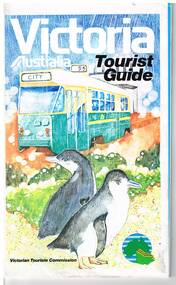
Map, Surveyor General for the Victorian Tourism Commission, "Victoria Australia Tourist Guide", 1985
Folded map of Victoria, showing in colour relief Victorian area, national parks, highways, towns, railways, airport, wine growing areas, towns with information centres, historic parks, ski fields. NSW and SA show major towns and highways. Front cover includes an image of a Z class tram and two penguins. Has town index. Folded 7 folds horizontally by 3 folds deep. On rear is a listing of locations with major tourist destinations provided. Provides location of VicTour offices. Prepared by the Surveyor General for the Victorian Tourism Commission, printed by the Government Printer, 4th edition 1985.trams, tramways, victoria, map, victour, tourism -
 Melbourne Tram Museum
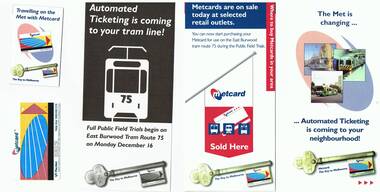
Pamphlet, The Met, "The Met is changing - automated ticketing", Dec. 1996
Set of pamphlets associated with the Metcard rollout and one Metcard ticket issued on 16/12/1996 on route 75. The envelope from the donor notes first Metcard (auto ticketing) and Associated brochures. .1 - Five folded to DL size - full colour pamphlet - "The Met is changing - automated ticketing is coming to your neighbourhood! - explains how the system works, purchasing of tickets and their use.] (Second copy added 3/12/2016) .2 - four fold to DL size - full colour pamphlet - "Metcards are on sale today at selected retail outlets" - providing on information on the purchase of Metcards and a map with associated addresses of outlets along route 75. .3 - single DL size sheet - black and white - explaining full field trials on route 75 and the use of Metcards. .4 - small pocket size 6 fold full colour sheet explaining how the Metcards could be purchased on the trams and validated. .5 - Metcard No. 00383158 - with the Metcard logo, The Met logo, validated at 1242pm on 16/12/1996. .6 - five fold DL - as for .2, for tram routes 3,64, 67, 78 and 79. .7 - five fold DL - similar to .1, more general document. .8 - 3 fold DL - "Everything you need to know about automated ticketing in three words" - What, When and How - explains Metcard. Could be a very early pamphlet.trams, tramways, tickets, metcard, ptc, the met, neighbourhood tickets, route 75, route 3, route 64, route 67, route 68, route 79 -
 Melbourne Tram Museum
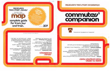
Pamphlet, Minister of Transport, "Commuters' Companion", Mid to late 1970's
Pamphlet, folded sheet, four folds, full colour on white gloss paper titled "Commuters' Companion", published by the Ministry of Transport, providing transport information, contact numbers for bookings, special party hiring's, lost property, VicRail, Tramways Board, Transport Information line. On inside has photos of Silver train, Z 1, main city rail stations, map of central Melbourne, the Transport information centre work room (not a PC to be seen - early cubicles), a Yellow cab taxi at TRB Port Melbourne and a School bus. Telephone numbers a mix of 6 and 7 digit numbers. Mid to late 1970's.In ink in top left hand corner "4J40" - AETA Library location.trams, tramways, minister for transport, melbourne -
 Melbourne Tram Museum
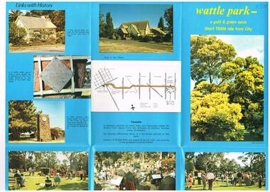
Pamphlet, Melbourne & Metropolitan Tramways Board (MMTB), "Wattle Park - a gold and green oasis", Mid to late 1970's
Pamphlet, folded sheet, six folds, full colour on blue background gloss paper titled "Wattle Park - a gold and green oasis" giving information on the park, its history, management (MMTB) and sporting uses. Has a number of photos of sporting activities, the Tramways band, buildings, the Lone Pine tree. On the rear is a map showing route 70 and details of the tram timetable. In the bottom right hand corner of the pamphlet are the words "MTB Publication". No contact numbers or addresses given. Printed in the same style as Reg Item 594. Second copy added 19-1-2017 from donation of John PrideauxIn ink in top left hand corner "4J40" - AETA Library location.trams, tramways, wattle park, mmtb -
 Melbourne Tram Museum
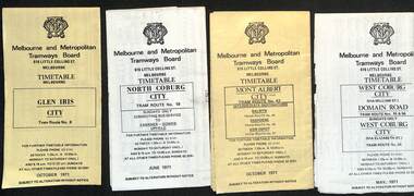
Ephemera - Timetable, Melbourne & Metropolitan Tramways Board (MMTB), MMTB Tram timetables, set of 12, 1971
Timetables for specific routes, day of week giving information on tram times at specific time points, route map, sections and fares and organisation address - 616 Little Collins St. Melbourne. 1 - Glen Iris - City route 6 - Oct. 1971 2 - North Coburg with connecting bus to Fawkner and Gowrie - Upfield on Sundays - June 1971 3 - Mont Albert - City - routes 42, 44, 45, 37 - Oct. 1971 4 - West Coburg - Domain Road and West Coburg City on Sundays - routes 55, 56 and 68 - May 1971 5 - Essendon Aerodrome - City route 59 - June 1971 6 - East Brighton - City - routes 64, 65, 62, 61 - Oct. 1971 7 - Carnegie - City - routes 67, route 66 - Oct. 1971 8 - Wattle Park - City route 70, route 71 and route 76 - Oct. 1971 9 - Camberwell - City - route 72, route 73 - Oct. 1971 10 - Prahran - City, North Richmond -Prahran - St Kilda Beach, routes 77, 78 and 79 - Oct. 1971 11 - East Preston - City and East Brunswick - City - routes 88, 89, 90. 96 and 97 - Oct. 1971 12 - ditto for Sundays printed on green paper. 13 - Route 8, Toorak, Oct. 1971-*Yields information about 1971 MMTB timetables.Set of 12 1971 MMTB Tram timetables, folded sheets.trams, tramways, timetables, mont albert, route 42, route 6, route 19, upfield, route 44, route 45, route 37, route 55, route 56, route 68, route 59, route 64, route 65, route 62, route 61, route 67, route 66, route 70, route 71, route 76, route 72, route 73, route 77, route 78, route 79, route 88, route 90, route 96, route 97, route 8 -
 Melbourne Tram Museum
Document - Folder with papers, The Met, "Melbourne Met Pass", Sep. 1987
Folder containing various documents regarding the launch of the "Melbourne Met Pass". .1 - Green coloured folded card folder with the Met logo and "Metropolitan Transit" on the outside and two The Met business cards for Jennie Owers - Manager Sales and Services and Margaret Douglas, General Manager Marketing stapled to the inside. .2 - Two page press release headed "Victoria Transport", dated 19/9/1987 regarding the launch of the new Tourist Package by the Met, has quotes from MTA Managing Director - Kevin Shea and Minister Tom Roper. .3 - Folded card A5 sheet, titled "All the information you need to tell them where to go", contains retail and wholesale price information and information on the packages available. .4 - Poster, printed on gloss paper and folded titled "101 things to see around Melbourne" advertising what you could see using the Met Pass. Contained within a green plastic folder titled "Melbourne Met Pass" .5 - book - 80 pages, card cover, printed on gloss paper - a very extensive guide to Melbourne and suggested trips. .6 - folded map showing both the train and tram systems containing information about the zones, art galleries, shopping, gardens sports Arena, museums and eating. .7 - Sample Met Pass - not numbered - printed on yellow card with green ink and conditions of travel on rear.trams, tramways, the met, tourist tickets -
 Melbourne Tram Museum
Map, Melbourne & Metropolitan Tramways Board (MMTB), MMTB Route Maps, 1979
Series of colour maps for various tram and bus routes, dated 1979. Also contained, not scanned are letters, reports, and specifications for printing these maps for use in shelters etc. Some have the Transport Information Centre telephone printed on them. Some are finished with a plastic laminate finish on either one or both sides. Show the major cross streets, parks, schools, other tram routes, major stop numbers, and railway lines. See also item 3909 for another example of these. Trams 1 - City route guide - R9/77 - showing all route numbers and destinations that passed through the CBD. 2 - Bourke St tram routes - R4/77 - East Brunswick Blyth St and East Preston Tyler St and intermediate routes, routes 95, 96, 97, 90, 89 and 88. 3 - Malvern, East Malvern, Carnegie, and East Brighton Tram Routes (from St Kilda Junction) - R1/79 - shows routes 5, 3, 67, 66, 61, 62, and 64. 4 - Elizabeth St tram routes - R12/77 - Essendon Airport, West Maribyrnong, North Coburg lines, routes 50, 58, 60, 54, 57, 52. 49, 59, 18, 20 and 19 5 - Flinders St tram routes - R5/78 - North Balwyn, East Burwood, routes 48, 40, 41, Hartwell, 28, 74 and 75 6 - Kew - St Kilda Beach - R1/79 - Route 69. 7 - Mont - Albert City - R11/77, shows routes 43. 47. 45. 44 8 - St Kilda Rd Tram Routes R12/77 - details South Melbourne Beach, route 1 and route 2 and St Kilda Beach routes 15, 16, and 55 otherwise shows where the various routes branch off St Kilda Road 9 - Batman Ave tram routes - R9/77 - Wattle Park, North Richmond and Prahran - routes 70, 71, 78 and 79. 10 - Footscray - Moonee Ponds - R3/81 - Route 82 11 - Swanston St tram guide - R1/79 - lists all routes and route numbers that branch or cross Swanston St between Grattan St and St Kilda Junction. 12 - Toorak Camberwell and Glen Iris tram route with Camberwell Junction and Malvern Town Hall, R1/79, routes 8, 7, 6, 72, and 73 shown. 13 - West Preston - Beach tram routes - R12/77 - routes 10, 11, 9 and 12, 14 - William St tram routes - R12/77 - Route 55, 56, and 63 - South Melbourne Depot and Domain. Buses 1 - Footscray, Sunshine, Deer Park, Nth Altona & Fishermans Bend - R2/79 2 - Box Hill bus routes to Templestowe, Heidelberg & East Kew - R6/78 - notes superseded by R3/82 3 - Plan of Russell St Melbourne bus departure bays. 4 - Box Hill, Mitcham & Ringwood bus routes to East Doncaster & Warrandyte - R3/82 5 - City - Warrandyte & East Doncaster bus routes - R3/82 & R6/78 6 - Bulleen - City - Port Melbourne - Garden City Bus route - R6/78 7 - North Altona - City bus route - 11/78 8 - Clifton Hill - Elsternwick - R2/79 9 - La Trobe - Northland - West Heidelberg - City Bus Service via East Freeway - 11/79 and R3/81 10 - Box Hill, Mitcham & Ringwood Bus Routes to East Doncaster & Warrandyte - R10/84 - with the Metropolitan Transit logo.Yields information about tram and bus routes in late 1970s early 1980s.Book - brown comb binding, card and clear plastic covers containing both bound and unbound maps and documents.K C Painter on front cover in ink.tramways, mmtb, tram routes, maps, bus routes, route numbers, routes, route guide -
 Melbourne Tram Museum
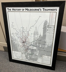
Poster - Framed, Stephen Watson, "The History of Melbourne's Tramways"
Framed post titled "The History of Melbourne's Tramways", providing a detailed map, showing the opening, closing, dates, and notes of Melbourne's horse, cable, electric tramways and railways. Printed on an image of cable trams in Collins St with the Melbourne Town Hall in the background. Has notes on closures, track layouts, accuracy, and acknowledgments. Prepared by Stephen Watson and Ian Johnson in 2006, 3rd Edition See item 506 for other issues. Yields information about the development of the Melbourne tramways and the system.Wooden bevel edge, dark brown stain, framed poster glazed with paper backing.melbourne, map, tramways, cable trams, horse trams, box hill, vr trams -
 Melbourne Tram Museum
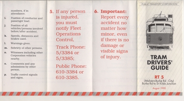
Pamphlet, Public Transport Corporation (PTC), "Tram Drivers' Guide RT 5", Aug. 1990
Pamphlet for tramcars, sheet of paper folded into pocket size, 12 folds, printed on gloss paper with black and red colours titled "Tram Drivers' Guide RT 5", providing g a map for the Route 5 Malvern Bourke Road from Burke Road to St Kilda Road, showing notes for both directions, compulsory stops, facilities and features. On the reverse side, has notes regarding classes of tram, information about accidents and telephone numbers. Dated August 1990. 2nd copy added 11-12-17 from Donation of Ron Scholten.trams, tramways, ptc, malvern burke rd, accidents, tram drivers, map -
 Melbourne Tram Museum
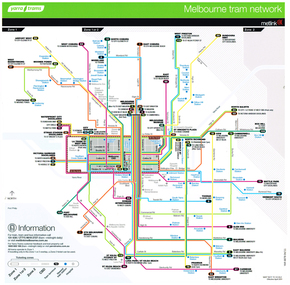
Poster, Yarra Trams, "Melbourne Tram Network", Jan. 2014
Full colour poster printed on a vinyl plasticized based sheet, titled "Melbourne Tram Network" - showing a diagrammatic layout of Melbourne tram routes, Myki ticket notes and where tickets can be obtained, information numbers (PTV, phone applications) and information on Tram Tracker, twitter and other contact systems. Map replaced when changes made to routes 112 (split into 11 and 12 - St Kilda to Victoria Gardens) from 27/7/2014. Map dated Jan. 2014. See Reg Item 725 for a vertical format version.trams, tramways, yarra trams, ptv, maps, tramtracker, myki -
 Melbourne Tram Museum
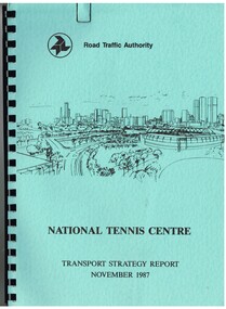
Document - Report, Dennis Johnston and Associates, Road Traffic Authority, "National Tennis Centre - Transport strategy Report November 1987", 1987
Report - 35 pages, within light blue covers, comb bound with black binder, titled "National Tennis Centre - Transport strategy Report November 1987". Report looks at the then planned Tennis Centre precinct and use of public transport in order to access it. It includes coach and car parking and how to handle various modes. Includes the MCG carpark, maps, parking areas, walking paths, access points. At the time, the tram line was located in Batman Ave. Also includes notes on the public information campaigns. Produced with the assistance of the MTA. Report prepared by Dennis Johnston and Associates for the Road Traffic Authority.trams, tramways, public transport, tennis centre, melbourne, mta -
 Melbourne Tram Museum
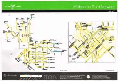
Poster, Yarra Trams, "Melbourne Tram Network", Apr. 2011
Full colour poster printed on a vinyl plasticized based sheet titled "Melbourne Tram Network. Shows a diagrammatic layout of the Melbourne tram system, shows zones, CBD, tram terminuses, train station and hospitals. Has the Yarra Trams and Metlink logos. Provides contact information including a website. Dated Effective April 2011. See also Reg item 721 for Jan. 2014 version. 2 copies held.trams, tramways, yarra trams, metlink, maps -
 Melbourne Tram Museum
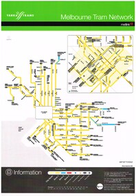
Poster, Yarra Trams, "Melbourne Tram Network", Sep. 2006
Full colour poster printed, A3 size, on laminated sheet - titled "Melbourne Tram Network. Shows a diagrammatic layout of the Melbourne tram system, shows zones (2 zones), CBD, tram terminuses. Has the Yarra Trams and Metlink logos. Provides contact information including a website. Dated Effective September 2006. Second copy added 8/5/2019 from donation of Colin Withington of 10/10/2009.trams, tramways, yarra trams, metlink, maps, metcard -
 Melbourne Tram Museum
Poster, Yarra Trams, "Melbourne Tram Network", Sep. 2006
Full colour poster, A3 size, printed on laminated sheet - titled "Melbourne Tram Network. Shows a diagrammatic layout of the Melbourne tram system, shows zones (3 zones), CBD, tram terminuses, train station, park and ride locations. Has the Yarra Trams and Metlink logos. Provides contact information including a website. Notes where Metcards are available. Two copies held. Vertical format of Reg Item 719. Dated Effective September 2006. 720.2 - dated Jan. 2005 - shows the Vermont South extension under construction - see image i2. Item added 11-8-2016. 720.3 - undated - prior to Vermont South opened in 2005 - has route 112 and docklands tram line - c2004. Does not have a Yarra Trams logo.trams, tramways, yarra trams, metlink, maps, metcard, vermont south -
 Melbourne Tram Museum
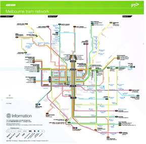
Poster, Yarra Trams, "Melbourne Tram Network", January 2014
Full colour poster printed on a vinyl plasticized based sheet titled "Melbourne Tram Network. Shows a diagrammatic layout of the Melbourne tram system, shows zones, CBD, tram terminuses, train stations, low floor tram priority routes and hospitals. Has the Yarra Trams logos. Provides contact information (PTV) including a website. Dated Effective - January 2014. See also Reg item 718 for the April 2011 version.trams, tramways, yarra trams, metlink, maps, ptv -
 Melbourne Tram Museum
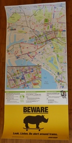
Poster, Yarra Trams, CBD and inner city tram routes, January 2012
Full colour poster printed on a vinyl plasticized based sheet showing all the public transport routes to the north and south of the CBD, includes major landmarks. Has information on where to buy tickets, customer information and tram tracker. At the base has a Beware Rhino's image. Has the Melway image as well. Dated Effective - January 2012.trams, tramways, yarra trams, maps, ptv, melbourne, public transport, rhinos -
 Melbourne Tram Museum
Poster, Yarra Trams, "Melbourne Tram Network", Jan. 2014
Full colour poster printed on a vinyl plasticized based sheet, titled "Melbourne Tram Network" - showing a diagrammatic layout of Melbourne tram routes, Myki ticket notes and where tickets can be obtained, information numbers (PTV, phone applications) and information on Tram Tracker, twitter and other contact systems. Vertical format. Map replaced when changes made to routes 112 (split into 11 and 12 - St Kilda to Victoria Gardens) from 27/7/2014. Map dated Jan. 2014. See Reg Item 625 for a horizontal format version and 726 for an earlier version. Two copies held.trams, tramways, yarra trams, ptv, maps, tramtracker, myki -
 Melbourne Tram Museum
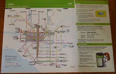
Poster, Yarra Trams, "Melbourne Tram Network", Dec. 2012
Full colour poster printed on a vinyl plasticized based sheet, titled "Melbourne Tram Network" - showing a diagrammatic layout of Melbourne tram routes, Myki ticket notes and where tickets can be obtained, information numbers (PTV, phone applications) and information on Tram Tracker, twitter and other contact systems. Map shown as effective April 2011, and printed December. 2012. Has the document information on the right hand side of the poster. See Reg Item 625 for a later version.trams, tramways, yarra trams, ptv, maps, tramtracker, myki -
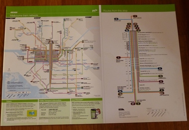
 Melbourne Tram Museum
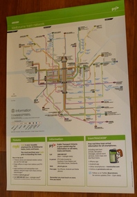
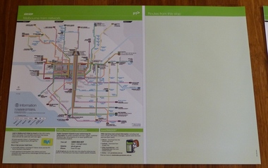
Poster, Yarra Trams, "Melbourne Tram Network" and "Routes from this stop", Dec. 2012
Full colour poster printed on a vinyl plasticized based sheet, titled "Melbourne Tram Network" - showing a diagrammatic layout of Melbourne tram routes, Myki ticket notes and where tickets can be obtained, information numbers (PTV, phone applications) and information on Tram Tracker, twitter and other contact systems on the left side and a blank right side titled "Routes from this stop" Map shown as effective April 2011, and printed December. 2012. Has the document information on the right hand side of the poster. See Reg Item 628 for an example of how this base poster was used. Two copies held.trams, tramways, yarra trams, ptv, maps, tramtracker, myki -
 Melbourne Tram Museum
Poster, Yarra Trams, "Melbourne Tram Network" and "Routes from this stop", Apr. 2011
Full colour poster printed on a vinyl plasticized based sheet, titled "Melbourne Tram Network" - showing a diagrammatic layout of Melbourne tram routes, Myki ticket notes and where tickets can be obtained, information numbers (PTV, phone applications) and information on Tram Tracker, twitter and other contact systems on the left side and on the right side titled "Routes from this stop" showing all the routes that ran in Swanston St to Melbourne University and the major stops in the City and St Kilda Road. Map shown as effective April 2011. Has the document information on the right hand side of the poster.trams, tramways, yarra trams, ptv, maps, tramtracker, myki, swanston st, st kilda rd -
 Melbourne Tram Museum
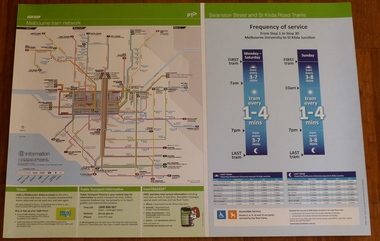
Poster, Yarra Trams, "Melbourne Tram Network" and "Swanston St and St Kilda Road Trams", Apr. 2011
Full colour poster printed on a vinyl plasticized based sheet, titled "Melbourne Tram Network" - showing a diagrammatic layout of Melbourne tram routes, Myki ticket notes and where tickets can be obtained, information numbers (PTV, phone applications) and information on Tram Tracker, twitter and other contact systems on the left side and on the right side titled "Swanston St and St Kilda Road Trams" showing the frequency of service from Stop 1 to Stop 30 - Melbourne University to St Kilda Junction. Has a table showing the first and last trams to each of the routes for Monday to Thursday, Friday, Saturday and Sunday. On the base has notes regarding accessible services. Map shown as effective April 2011. Has the document information on the right hand side of the poster.trams, tramways, yarra trams, ptv, maps, tramtracker, myki, swanston st, st kilda rd -
 Melbourne Tram Museum
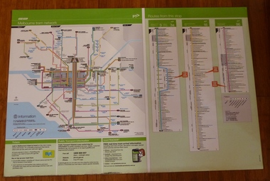
Poster, Yarra Trams, "Melbourne Tram Network" and "Routes from this Stop", Dec. 2012
Full colour poster printed on a vinyl plasticized based sheet, titled "Melbourne Tram Network" - showing a diagrammatic layout of Melbourne tram routes, Myki ticket notes and where tickets can be obtained, information numbers (PTV, phone applications) and information on Tram Tracker, twitter and other contact systems on the left side. On the right side titled "Routes from this Stop" is the information and detailed plan of every stop on routes 3, 3a, 16 and 96, including buses and train stop and connecting tram services. Printed for Stop 136, The Esplanade. Map shown as effective April 2011, printed December 2012. Has the document information on the right hand side of the poster. Two copies held.trams, tramways, yarra trams, ptv, maps, tramtracker, myki, the esplanade, route 96, route 3, route 16 -
 Melbourne Tram Museum
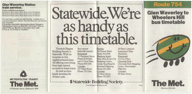
Ephemera - Timetable, Metropolitan Transit Authority (MTA), Bus Route 754, Glen Waverley to Wheelers Hill, Oct. 1984
Printed fold out timetable for Bus Route 754, Glen Waverley to Wheelers Hill, published by The Met, effective 29/10/1984. Provides a map, description of route, time points, timetable, ticketing information (Travel cards and Neighbourhood tickets) and the Glen Waverley Railway station and train service. Has a sponsored advert by the Statewide Building Society. Has logos of the Met. Folded into four.trams, tramways, tickets, the met, bus services, timetables, neighbourhood tickets -
 Melbourne Tram Museum
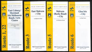
Ephemera - Timetable, Public Transport Corporation (PTC), Set of 24 The Met tram timetables, 1995
Set of 24 The Met Public Timetables.Demonstrates tram timetables published by The Met during 1995..1 - Printed 20 page book stapled timetable for East Coburg / Moreland Sth Melbourne Arts centre tram service, Route 1 and 22, dated April 1995. The "The Met" logo, was published by the Public Transport Corporation. Provides a map, description of route, time points, timetable, ticketing information, some ticketing information, introduction by the relevant Depot, including a photo - and an image of a tram available for hire as a party tram. .2 - Route 3 - East Malvern - City - April 1995 .3 - Route 5 - Malvern (Burke Road - City - April 1995 .4 - Route 6 - Glen Iris - City - April 1995 .5 - Route 8 - City - April 1995 .6 - Route 11 - City - April 1995 .7 - Route 11 - City - Nov. 1995 .8 - Route 12 - Sth Melbourne Beach and St Kilda Beach - City - April 1995 .9 - Route 16 - St Kilda Beach - City - April 1995 .10 - Route 19 - North Coburg - City - Nov 1994, revised 8/1995 .11 - Route 48 - North Balwyn - City - 30/4/1995, revised 9/1995 .12 - Route 64 - East Brighton - City - April 1995 .13 - Route 64 - East Brighton - City - Nov. 1995 .14 - Route 67 - Carnegie - City - April 1995 .15 - Route 67 - Carnegie - City - August 1995 .16 - Route 69 - Kew Cotham Road - St Kilda Beach - April 1995 .17 - Route 70 - Wattle Park - City - April 1995 .18 - Route 72 - Camberwell - City - April 1995 .19 - Route 75 - East Burwood - City - April 1995, revised 8/1995 .20 - Route 78/79 - North Richmond - St Kilda Beach or Prahran - April 1995 .21 - Route 86 - Bundoora - City - Oct 1995. .22 - Route 109 - Port Melbourne - Mont Albert April 1995 .23 - Route 109 - Port Melbourne - Mont Albert August 1995 .24 - La Trobe St Service - City - East Melbourne April 1995trams, tramways, tickets, the met, tram services, timetables, route 69, route 1, route 22, route 3, route 5, route 6, route 8, route 11, route 12, route 16, route 19, route 48, route 64, route 72, route 75, route 78, route 79, route 86, la trobe st - east melbourne, route 67, route 70, route 109 -
 Melbourne Tram Museum
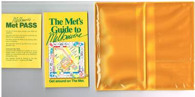
Book, The Met, "Met Pass", late 1980's
... with maps, guides and information about various locations within.... Rail Map - shows Route 96 north section as Light Rail, co ...Yellow plastic folder titled "Melbourne Met Pass", with The Met logo in green print on both sides of the outside of the folder. On the inside has two pockets for storing items formed with clear plastic. Map Folded Map of Melbourne Rail and Tram lines, titled "The Met PASS Map to Melbourne" Tram Map - probably soon after conversion of the St Kilda and Port Melbourne lines to Light Rail, though these are not shown. Opened November 1987. Rail Map - shows Route 96 north section as Light Rail, co-ordinated bus routes, and the Altona line as going to Werribee. This route was opened in 1985. Date of Map c1988/1990. Has details of Museums, Art Galleries, Shopping, Gardens and Sports Arenas in Japanese. Sheet of paper advising users on presentation of the Met Pass (not included in the folder) Book - titled "The Met's Guide to Melbourne", sub titled - Get around on The Met. Card covers, perfect bound, 100 pages in colour with maps, guides and information about various locations within Greater Melbourne including Werribee Zoo and Healesville. See also Reg Item 106 to 108 for a similar item and 983 for the document that was used to launch the Met Pass. Two copies held.trams, tramways, the met, melbourne, tickets, tourist tickets -
 Bendigo Historical Society Inc.
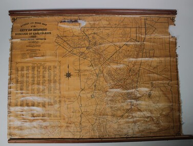
Map - Map of Bendigo streets
Situated at Cowlings Ford Dealership and Garage in Bendigo to enable employees to find streets from 1930 to 1970 when Cowlings closed.Paper on canvas wall map. Street and Road map of City of Greater Bendigo, Borough of Eaglehawk and Surrounding Districts. Wooden hanging rod on top edge. Wooden rod on lower edge has detached. Light brown background. Printed in black and red. Includes Street indexes, historical information and key to points of interest.eaglehawk, map, cowlings garage bendigo -
![Map, Millbank Estate Bacchus Marsh Thursday 4th October 1888 [Land sales], 1924](/media/collectors/5e461d8021ea67224c82f2a1/items/67765662eb6d2cbd24e0797f/item-media/67765682eb6d2cbd24e07a41/item-fit-380x285.jpg) Bacchus Marsh & District Historical Society
Bacchus Marsh & District Historical SocietyMap, Millbank Estate Bacchus Marsh Thursday 4th October 1888 [Land sales], 1924
The Millbank Estate was a parcel of land close to the centre of the shopping area of Bacchus Marsh which was sub-divided and offered for sale in 62? lots on the 4th October 1888. The lots had frontages to Ballarat Road (Main Street), Maddingley Road (now Grant Street), Turner Street, Millbank Street, Clarinda Road (now Clarinda Street), and an unnamed street south of Turner Street (possibly known as Grant Street at this time) which connected to Maddingley Road through the vicinity of the present day Bacchus Marsh Hospital. This was a significant sub-division of land and represented a major expansion of residential housing in Bacchus Marsh in the late 19th century. The map includes a wealth of detail about the time of the sale, where it will take place, who the selling agents were, the deposit terms for purchases and details of a special train from Melbourne to Bacchus Marsh on sale day. The location of the allotments in relation to the shopping and commercial area of Bacchus Marsh, Maddingley and the railway station are indicated on an inset map within the overall map and poster. The Millbank Estate area was an area which had once belonged to the Grant family who were prominent early citizens of Bacchus Marsh and lived in a house in this area known as 'Millbank'.This land sale map is a typical example of housing estate land sales advertising maps produced by real estate agents in this era. The map is significant for the detailed information it provides about when and where land was sold for new housing estates in Bacchus Marsh in the late nineteenth century.Single page map showing land allotments for sale at auction in Bacchus Marsh in October 1888. A significant portion of the map is missing from the bottom right side. land sales bacchus marsh, land subdivsion bacchus marsh, housing estates land sales bacchus marsh, grant family bacchus marsh, millbank estate land sales -
 Falls Creek Historical Society
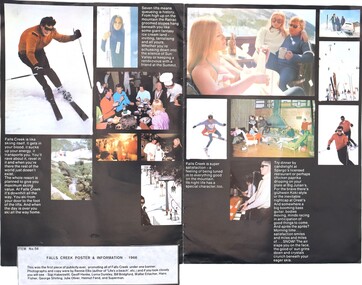
Poster - Falls Creek Information, 1966
This item is from the private collection of George Shirling of Red Onion, Falls Creek. This brochure was the first promotional material jointly published by operators at Falls Creek. The attached label makes reference to many pioneers of the Falls Creek Village. George Shirling arrived in Falls Creek in 1962. He engaged Phil Nowell to build the original Koki Alpine Lodge which opened in 1965 with 14 beds. George operated the lodge with Michael “Baldy” Blackwell as manager. He also graduated in sport psychology in 1981 and was invited to become team psychologist for the Australian Winter Olympic team which went to Albertville, France, in 1992. He later owned the Red Onion Chalet. George credited the success of Koki to “Baldy” Blackwell. “Baldy” and Phil Nowell started the Trackers Mountain Lodge in partnership during the 1980s. In 1971 George sold Koki Lodge to Sigi Doerr. In 2024 the renamed Koki Alpine resort remains a highly popular destination in Falls Creek. George Shirling passed away on 27th February 2023. He had remained actively involved in Falls Creek and was generous with his time and knowledge, always an amazing supporter of The Falls Creek Museum and Falls Creek Village.This poster is significant because it was the first joint promotional material used to market Falls Creek in 1966.A coloured information brochure for Falls Creek including a map and images. It has been made into a poster for display. A typed label is attached. On label: ITEM NO 56 This was the first piece of publicity ever, promoting all of Falls Creek under one banner. Photographs and copy were by Rennie Ellis (author of "Life's a beach", etc) and if you look closely see you will see - Sigi Haberzetti, Geoff Henke, Loma Dunkley, Bill Bridgford, Walter Erlacher, Hans Fisher, George Shirling, Julie Oliver, Helmut Fend, and Superman. george shirling, falls creek marketing, falls creek 1966