Showing 2994 items matching "parks victoria"
-
 Emerald Museum & Nobelius Heritage Park
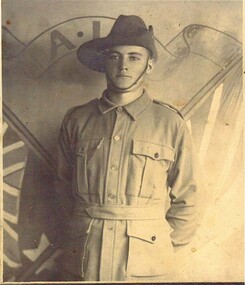
PHOTO, Eric William John Durance
Eric William John Durance ,Son of William and Margaret Durance of Macclesfield. Rank.Private. Service no. 812. Unit 22 nd Battalion Service Army Conflict 1914-1918 Date of Death 4th October 1915. Cause of Death Died of Wounds. CEMETERY OR MEMORIAL DETAILS. 6 Lone Pine Memorial Gallipoli. Place of enlistment Gembrook West Victoria. Native Place. Macclesfield Victoria War Grave Register notes. DURANCE, PTE. Eric William John, 812.22nd Bn. Died of wounds 4th. Oct. 1915. Son of William John Durance and Margaret Madigan (his ). Native of Macclesfield, Victoria, Australia. 65 Source. AWM145 Roll of Honour cards.1914-1918 War Army. LOCATION on the Roll of Honour. Eric Williams John Durance's name is located at panel 96 in the Commemorative Area at the Australian War Memorial (as indicated by the poppy on the plan).1914-1918 War Age at time of death 21Photo of Eric William Durance in his uniform from the 1914-1918 war.1st world war. -
 RSL Victoria - Anzac House Reference Library and Memorabilia Collection
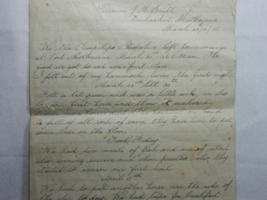
Diary of John McMahon Smith, John McMahon Smith, March 1915 to June 1915
Diary covers the period from embarkation in Melbourne on board Shropshire on 20 March 1915, to entering the Bay of Biscay on 12 June 1915.Nine handwritten pages pinned together and dated 20 March 1915. Written by John Smith ( 5689 - Australian Reserve Park 1, Reinforcement 4).ww1, diaries, john mcmahon smith, australian reserve park 1 -
 RSL Victoria - Anzac House Reference Library and Memorabilia Collection
Photograph, Macleod Repatriation Sanitorium, circa 1914
... Mont Park, Victoria ...The former Mont Park/Bundoora Psychiatric and Repatriation Hospitals Complex consisted of seven hospitals on a site of 185 hectares. The site comprising the Mont Park and Strathallen estates was consolidated by the Victorian government by purchase and transfer from the Closer Settlement Board in 1909 . The Mont Park Hospital commenced in 1910 with the building of the Farm Workers Block . In 1912 the landscape gardener Hugh Linaker was employed to layout the grounds of Mont Park and other State mental hospitals. The other hospitals were gradually split off from the Mont Park administration to form separate entities included among these was the Macleod Repatriation Hospital (1915), An agreement was made with the Defence Department in 1914 for the latter to erect the Mont Park central block (the "Chronic Wards") for use as a Military Hospital, and for it later to revert to the State as portion of Mont Park Hospital. The buildings now known as the Chronic Wards were completed in this way in 1916 and used as the Australian General Hospital no. 16 for the duration of the war. One wing of this building was set aside for mental patients during this period. Silver gelatin photographww1, macleod repatriation sanitorium, mont park -
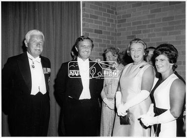
 Eltham District Historical Society Inc
Photograph, Shire of Eltham Centenary Dinner, 6 Apr 1971
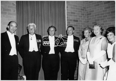
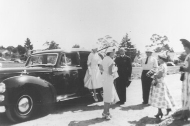
Shire of Eltham Centenary Dinner; Official Guests - Left to Right: His Excellency Major General Sir Rohan Delacombe, K.C.M.G., K.C.V.O., K.B.E., C.B., D.S.O., D.St.J., Governor of Victoria; Cr. G.C. Dreverman, Shire President; Mrs. Hamer; Lady Delacombe and Mrs. Dreverman. The event was held in the West Riding Hall, Petrie Park Community Centre, Montmorency. This photo forms part of a collection of photographs gathered by the Shire of Eltham for their centenary project book, "Pioneers and Painters: 100 years of the Shire of Eltham" by Alan Marshall (1971). The collection of over 500 images is held in partnership between Eltham District Historical Society and Yarra Plenty Regional Library (Eltham Library) and is now formally known as 'The Shire of Eltham Pioneers Photograph Collection.' It is significant in being the first community sourced collection representing the places and people of the Shire's first one hundred years.Digital imagesepp, shire of eltham pioneers photograph collection, shire of eltham, shire of eltham centenary, the hon. r.j. hamer, official dinner, mrs. hamer, mrs. dreverman, m.b. watson, lady delacombe, sir rohan delacombe, cr. g.c. dreverman, centenary celebrations, formal wear, petrie park community centre montmorency -
 Eltham District Historical Society Inc
Photograph, Shire of Eltham Centenary Dinner, 6 Apr 1971
Shire of Eltham Centenary Dinner; Official Guests - Left to Right: His Excellency Major General Sir Rohan Delacombe, K.C.M.G., K.C.V.O., K.B.E., C.B., D.S.O., D.St.J., Governor of Victoria; Cr. G.C. Dreverman, Shire President; Mrs. Hamer; Lady Delacombe and Mrs. Dreverman. The event was held in the West Riding Hall, Petrie Park Community Centre, Montmorency. This photo forms part of a collection of photographs gathered by the Shire of Eltham for their centenary project book, "Pioneers and Painters: 100 years of the Shire of Eltham" by Alan Marshall (1971). The collection of over 500 images is held in partnership between Eltham District Historical Society and Yarra Plenty Regional Library (Eltham Library) and is now formally known as 'The Shire of Eltham Pioneers Photograph Collection.' It is significant in being the first community sourced collection representing the places and people of the Shire's first one hundred years.Digital imagesepp, shire of eltham pioneers photograph collection, shire of eltham, shire of eltham centenary, the hon. r.j. hamer, official dinner, mrs. hamer, mrs. dreverman, lady delacombe, sir rohan delacombe, cr. g.c. dreverman, centenary celebrations, formal wear, petrie park community centre montmorency -
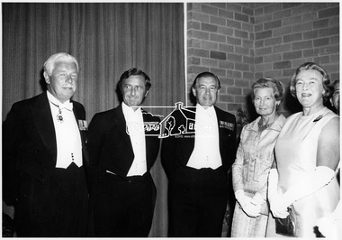 Eltham District Historical Society Inc
Photograph, Shire of Eltham Centenary Dinner, 6 Apr 1971
Shire of Eltham Centenary Dinner; Official Guests - Left to Right: His Excellency Major General Sir Rohan Delacombe, K.C.M.G., K.C.V.O., K.B.E., C.B., D.S.O., D.St.J., Governor of Victoria; Cr. G.C. Dreverman, Shire President; The Hon. R.J. Hamer, E.D., M.P., Chief Secretary of Victoria; Mrs. Hamer; Lady Delacombe. The event was held in the West Riding Hall, Petrie Park Community Centre, Montmorency. This photo forms part of a collection of photographs gathered by the Shire of Eltham for their centenary project book, "Pioneers and Painters: 100 years of the Shire of Eltham" by Alan Marshall (1971). The collection of over 500 images is held in partnership between Eltham District Historical Society and Yarra Plenty Regional Library (Eltham Library) and is now formally known as 'The Shire of Eltham Pioneers Photograph Collection.' It is significant in being the first community sourced collection representing the places and people of the Shire's first one hundred years.Digital imagesepp, shire of eltham pioneers photograph collection, shire of eltham, shire of eltham centenary, official dinner, mrs. hamer, mrs. dreverman, lady delacombe, sir rohan delacombe, cr. g.c. dreverman, centenary celebrations, the hon. r.j. hamer -
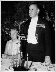 Eltham District Historical Society Inc
Photograph, Shire of Eltham Centenary Dinner, 6 Apr 1971
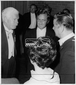
Lady Joyce Delacombe with The Hon. R.J. Hamer, E.D., M.P., Chief Secretary of Victoria speaking at the formal dinner to celebrate the Shire of Eltham's centenary. The event was held in the West Riding Hall, Petrie Park Community Centre, Montmorency. This photo forms part of a collection of photographs gathered by the Shire of Eltham for their centenary project book, "Pioneers and Painters: 100 years of the Shire of Eltham" by Alan Marshall (1971). The collection of over 500 images is held in partnership between Eltham District Historical Society and Yarra Plenty Regional Library (Eltham Library) and is now formally known as 'The Shire of Eltham Pioneers Photograph Collection.' It is significant in being the first community sourced collection representing the places and people of the Shire's first one hundred years.Digital imagesepp, shire of eltham pioneers photograph collection, shire of eltham, shire of eltham centenary, official dinner, centenary celebrations, the hon. r.j. hamer, lady delacombe, speech, talk -
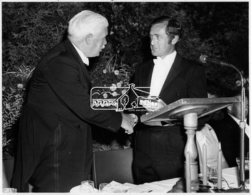 Eltham District Historical Society Inc
Photograph, Shire of Eltham Centenary Dinner, 6 Apr 1971
Cr. G. C. Dreverman presenting a silver centenary medal to His Excellency Major General Sir Rohan Delacombe, Governor of Victoria at the Shire of Eltham Centenary Dinner in 1971. The event was held in the West Riding Hall, Petrie Park Community Centre, Montmorency. This photo forms part of a collection of photographs gathered by the Shire of Eltham for their centenary project book, "Pioneers and Painters: 100 years of the Shire of Eltham" by Alan Marshall (1971). The collection of over 500 images is held in partnership between Eltham District Historical Society and Yarra Plenty Regional Library (Eltham Library) and is now formally known as 'The Shire of Eltham Pioneers Photograph Collection.' It is significant in being the first community sourced collection representing the places and people of the Shire's first one hundred years.Digital imagesepp, shire of eltham pioneers photograph collection, shire of eltham, shire of eltham centenary, official dinner, centenary celebrations, cr. g.c. dreverman, sir rohan delacombe -
 Eltham District Historical Society Inc
Photograph, Shire of Eltham Centenary Dinner, 6 Apr 1971
His Excellency Major General Sir Rohan Delacombe, Governor of Victoria at the Shire of Eltham Centenary Dinner in 1971 with Cr. G. C. Dreverman, Cr Glover and Mrs Glover. The Premier, Mr Hamer can be seen in the background. The event was held in the West Riding Hall, Petrie Park Community Centre, Montmorency. This photo forms part of a collection of photographs gathered by the Shire of Eltham for their centenary project book, "Pioneers and Painters: 100 years of the Shire of Eltham" by Alan Marshall (1971). The collection of over 500 images is held in partnership between Eltham District Historical Society and Yarra Plenty Regional Library (Eltham Library) and is now formally known as 'The Shire of Eltham Pioneers Photograph Collection.' It is significant in being the first community sourced collection representing the places and people of the Shire's first one hundred years.Digital imagesepp, shire of eltham pioneers photograph collection, shire of eltham, shire of eltham centenary, official dinner, centenary celebrations, cr. g.c. dreverman, sir rohan delacombe, cr. glover, mrs. glover -
 Eltham District Historical Society Inc
Photograph, Returned soldiers picnic, Police Paddocks, Queenstown, c.1916, c.1916
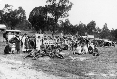
Possibly a picnic for returned servicemen from Gallipoli. This photo was taken in front of the Police Paddocks with the police station on the left. Model T Fords parked with soldiers, drivers and locals resting on the police paddock in front of the Queenstown (St Andrews) station. The RACV Volunteer Motor Corps service during World War One was the reason the organisation was granted its Royal prefix. Automobile Club of Victoria members volunteered their time and vehicles to collect returning soldiers and nurses from ships at Princes Pier, Port Melbourne. Trips were also often arranged for convalescing soldiers to country areas for picnics and to “revive spirits”. The soldiers were also picked up from the Austin Hospital in Heidelberg and Mont Park Military Hospital in Macleod. Queenstown (St Andrews) was a common picnic spot. The Evelyn Observer reported on June 9. 1916 "Some 75 returned soldiers visited Queenstown on Sunday, 28th ult., and were hospitably entertained by local residents who had provided refreshments sufficient for 150. Mr. Milne in an appropriate speech welcomed the soldiers, and Mr. Robison suitably responded.” The photo was reproduced page 108 of “The Diamond Valley Story" by Diane H. Edwards.This photo forms part of a collection of photographs gathered by the Shire of Eltham for their centenary project book,"Pioneers and Painters: 100 years of the Shire of Eltham" by Alan Marshall (1971). The collection of over 500 images is held in partnership between Eltham District Historical Society and Yarra Plenty Regional Library (Eltham Library) and is now formally known as the 'The Shire of Eltham Pioneers Photograph Collection.' It is significant in being the first community sourced collection representing the places and people of the Shire's first one hundred years.Digital image, 16 x 24 and 12.5 x 9 cm and 4 x 5 inch B&W Neg sepp, shire of eltham pioneers photograph collection, queenstown, cars, police station, st andrews, soldiers, picnic, exhibition yprl 2019-12, gallipoli, model t ford, pioneers and painters, police paddocks, retuned soldiers -
 Eltham District Historical Society Inc
Photograph, Murchison Gap, Autumn Excursion, Hume and Hovell's 1824 expedition, 26 May 1996, 26/05/1996
[article by Bettina Woodburn in EDHS Newsletter No. 109, July 1996:] ON THE TRAIL OF HUME AND HOVELL - REPORT ON THE AUTUMN EXCURSION - On a green and fresh morning (Sunday 26th May 1996) the Cobb and Co coach (driven by the most obliging Peter Tampion) set off in a north easterly direction from Eltham to connect with Hume and Hovell's route on their 1824 explorations of central Victoria. The Society would follow a series of monuments erected for the 1924 centenary of the expedition from King Parrot Creek (Tuesday 7th December 1824), through Strath Creek, over Sunday Creek (Sunday 12th December 1824) at Broadford, Tullamarine, St Albans, Deer Park, through Werribee, skirting east of the You Yangs to Lara and Avalon Beach. Because their distance-measuring wheel had broken and a one degree mistake was made in calculations, the two leaders of the original group of six convict-companions arrived at Corio Bay, instead of the expected Western Port, discovered earlier by Flinders. From below Mt. Disappointment (Hume and Hovell's difficulties in "scrambling over brush and rock", "leeches in forest, as well as no water", "cutting grass 4-5 ft. high", dreadful scrub", "devil flies") we took an easier route, saw the Strath Creek memorial in ground fog and a wonderful "field of dreams", the Hume-Hovell privately owned cricket ground with its white picket boundary fence. Now, after a steep climb, in sunshine under gums we stretched and viewed magnificent rolling hills and fog-filled valleys - not "smoke from Aborigines' bush fires". After morning tea at Broadford we followed the Sunday Creek valley beside the Hume Freeway, passed the Wallan Wallan Rest Area (more appropriately Hume and Hovell Rest Area) to tum right at Beveridge. In Gellibrand Hill Park, near the headwaters of the Moonee Ponds Creek, we experienced the landscape the first European settlers saw - huge river red gums and rolling pastures. The gardens and sheltered courtyard of the 1840s, timber, brought from .....[?] prefabricated Woodlands Homestead, provided a pleasant lunch stop. We enjoyed a private tour, panoramic views over Melbourne and surroundings and the excitement of arriving and departing aircraft. Our next river crossing was at Werribee, "in a vast treeless plain", then we drove on by-ways no coach had previously travelled, to find "an immense sheet of water" salty Corio Bay, off-course to the west. In late afternoon of a super, calm, late autumn day we headed homewards. Back at Eltham we were rather surprised to find that we had travelled a total of 347 km. Thanks again to Russell Yeoman for his research and organization. What a wonderful day! Three colour photographsactivities, murchison gap, murchison valley -
 Eltham District Historical Society Inc
Photograph, Hume and Hovell Monument, Broadford, Autumn Excursion, Hume and Hovell's 1824 expedition, 26 May 1996, 26/05/1996
[article by Bettina Woodburn in EDHS Newsletter No. 109, July 1996:] ON THE TRAIL OF HUME AND HOVELL - REPORT ON THE AUTUMN EXCURSION - On a green and fresh morning (Sunday 26th May 1996) the Cobb and Co coach (driven by the most obliging Peter Tampion) set off in a north easterly direction from Eltham to connect with Hume and Hovell's route on their 1824 explorations of central Victoria. The Society would follow a series of monuments erected for the 1924 centenary of the expedition from King Parrot Creek (Tuesday 7th December 1824), through Strath Creek, over Sunday Creek (Sunday 12th December 1824) at Broadford, Tullamarine, St Albans, Deer Park, through Werribee, skirting east of the You Yangs to Lara and Avalon Beach. Because their distance-measuring wheel had broken and a one degree mistake was made in calculations, the two leaders of the original group of six convict-companions arrived at Corio Bay, instead of the expected Western Port, discovered earlier by Flinders. From below Mt. Disappointment (Hume and Hovell's difficulties in "scrambling over brush and rock", "leeches in forest, as well as no water", "cutting grass 4-5 ft. high", dreadful scrub", "devil flies") we took an easier route, saw the Strath Creek memorial in ground fog and a wonderful "field of dreams", the Hume-Hovell privately owned cricket ground with its white picket boundary fence. Now, after a steep climb, in sunshine under gums we stretched and viewed magnificent rolling hills and fog-filled valleys - not "smoke from Aborigines' bush fires". After morning tea at Broadford we followed the Sunday Creek valley beside the Hume Freeway, passed the Wallan Wallan Rest Area (more appropriately Hume and Hovell Rest Area) to tum right at Beveridge. In Gellibrand Hill Park, near the headwaters of the Moonee Ponds Creek, we experienced the landscape the first European settlers saw - huge river red gums and rolling pastures. The gardens and sheltered courtyard of the 1840s, timber, brought from .....[?] prefabricated Woodlands Homestead, provided a pleasant lunch stop. We enjoyed a private tour, panoramic views over Melbourne and surroundings and the excitement of arriving and departing aircraft. Our next river crossing was at Werribee, "in a vast treeless plain", then we drove on by-ways no coach had previously travelled, to find "an immense sheet of water" salty Corio Bay, off-course to the west. In late afternoon of a super, calm, late autumn day we headed homewards. Back at Eltham we were rather surprised to find that we had travelled a total of 347 km. Thanks again to Russell Yeoman for his research and organization. What a wonderful day! Colour photographactivities, broadford, hume and hovell, monument -
 Eltham District Historical Society Inc
Photograph, Hume and Hovell Monument, Autumn Excursion, Hume and Hovell's 1824 expedition, 26 May 1996, 26/05/1996
[article by Bettina Woodburn in EDHS Newsletter No. 109, July 1996:] ON THE TRAIL OF HUME AND HOVELL - REPORT ON THE AUTUMN EXCURSION - On a green and fresh morning (Sunday 26th May 1996) the Cobb and Co coach (driven by the most obliging Peter Tampion) set off in a north easterly direction from Eltham to connect with Hume and Hovell's route on their 1824 explorations of central Victoria. The Society would follow a series of monuments erected for the 1924 centenary of the expedition from King Parrot Creek (Tuesday 7th December 1824), through Strath Creek, over Sunday Creek (Sunday 12th December 1824) at Broadford, Tullamarine, St Albans, Deer Park, through Werribee, skirting east of the You Yangs to Lara and Avalon Beach. Because their distance-measuring wheel had broken and a one degree mistake was made in calculations, the two leaders of the original group of six convict-companions arrived at Corio Bay, instead of the expected Western Port, discovered earlier by Flinders. From below Mt. Disappointment (Hume and Hovell's difficulties in "scrambling over brush and rock", "leeches in forest, as well as no water", "cutting grass 4-5 ft. high", dreadful scrub", "devil flies") we took an easier route, saw the Strath Creek memorial in ground fog and a wonderful "field of dreams", the Hume-Hovell privately owned cricket ground with its white picket boundary fence. Now, after a steep climb, in sunshine under gums we stretched and viewed magnificent rolling hills and fog-filled valleys - not "smoke from Aborigines' bush fires". After morning tea at Broadford we followed the Sunday Creek valley beside the Hume Freeway, passed the Wallan Wallan Rest Area (more appropriately Hume and Hovell Rest Area) to tum right at Beveridge. In Gellibrand Hill Park, near the headwaters of the Moonee Ponds Creek, we experienced the landscape the first European settlers saw - huge river red gums and rolling pastures. The gardens and sheltered courtyard of the 1840s, timber, brought from .....[?] prefabricated Woodlands Homestead, provided a pleasant lunch stop. We enjoyed a private tour, panoramic views over Melbourne and surroundings and the excitement of arriving and departing aircraft. Our next river crossing was at Werribee, "in a vast treeless plain", then we drove on by-ways no coach had previously travelled, to find "an immense sheet of water" salty Corio Bay, off-course to the west. In late afternoon of a super, calm, late autumn day we headed homewards. Back at Eltham we were rather surprised to find that we had travelled a total of 347 km. Thanks again to Russell Yeoman for his research and organization. What a wonderful day! Two colour photographsactivities, hume and hovell, monument -
 Orbost & District Historical Society
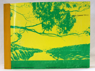
book, Report on the East Gippsland Study Area, June 1974
In 1961 Bruce Evans was elected to the Victorian Legislative Assembly as the member for Gippsland East. He was the party's deputy leader from 1964 to 1970 and its whip from 1970 until his retirement in 1992. "The Land Conservation Council was established by the Land Conservation Act 1970. As one of its three functions, it makes recommendations to the Minister for Planning and Environment with respect to the use of public land, in order to provide for the balanced use of land in Victoria. This report contains the Council’s final recommendations concerning the use of public land in the East Gippsland study area, the boundaries of which correspond to those of the Shire of Orbost. The recommendations in the text are grouped under major headings, such as Parks, State Forest, and so on. " The Council met on seven occasions during the year, and also made visits of inspection to each study area. The Chairman visited Shire Councils in study areas to explain the role and the functions of the Land Conservation Council and to invite submissions on the use of public land in these areas. This is the fourth annual report by the council. This is a useful research tool.A large book 236 pp book with a yellow / gold cover with a green bush scene . The binding is orange. It contains folded maps and information on public land use in East Gippsland.inside - "With Compliments - Bruce Evans, M.P."east-gippsland-study-area conservation public-land-use -
 Ringwood and District Historical Society
Photograph, Last remaining house on Eastland Shopping Centre site in Ringwood - 1985, 1985
Photos (3) of the former McKinley home (Mayor 1927/28) and later Rymers' at 22 Adelaide Street, Ringwood, Victoria, 1985, prior to demolition for expansion of Eastland Shopping Centre. Covering letter from Connie White, 2014. 1. Ringwood house (Myer car park) 1985 shot 2. Ringwood - old house, Myer car park 3. Ringwood old house - Myer car park -
 Ringwood and District Historical Society
Memorabilia, Brief community and sporting history of Augustus Temple Miles, former orchardist, Mayor of Ringwood, Victoria, and Ringwood District Cricket Association founder life member
Images and information later included in production of "From Paddocks to Parks", a history of the development of cricket in the Lilydale, Croydon, Ringwood and Ferntree Gully districts and of the Ringwood and District Cricket Association, by P.J. McCallum, OAM, Melbourne, April, 2001.2-page handwritten letter from A.T. Miles' son, Edward Temple Miles, accompanied by Ringwood Cricket Club photographs and memorabilia outlining his father's achievements. -
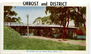 Orbost & District Historical Society
postcard series, 1960s
Included are photographs of the Orbost township, the Snowy River at Marlo, Gypsy Point, Buchan Caves and Bairnsdale. In the 1960s Orbost had a population of 4000 and was a major tourist attraction in Eastern Victoria with sufficient accommodation and facilities. It was the major town close to several national parks with access to either the surf or the snow. These postcards are pictorial records of Orbost in the 1960s. Postcards are very interesting records of places. architecture and transport.A colour postcard series with photographs of Orbost and the district. The cover photograph is of the Snowy River Bridge. There is an information card.Each photograph is labelled. at the bottom.postcards-orbost postcards-east-gippsland -
 Ringwood and District Historical Society
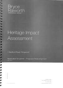
Book, Bryce Raworth, Heritage Impact Assessment - 1 Bedford Road, Ringwood, Victoria. Application for permit - Proposed Redevelopment - July 2021, 2021
A4 size wire-bound book compiled by Bryce RaworthINTRODUCTION: This heritage impact assessment (HIS) was prepared at the request of the City of Maroondah, the owner of the subject property at 1 Bedford Street (sic), Ringwood. It relates to a proposal to demolish the existing shop on the site and construct a multi-storey car park incorporating a commercial tenancy at the lower levels. It reviews the significance of the existing building on the site and the contribution it makes to the surrounding streetscapes, then comments on the heritage impacts of the proposed demolition in the context of the significance of the place and broader considerations. This office has previously provided an Historical Overview of the subject site (June 2020) and this assessment draws upon that previous research and analysis. The report has been prepared by Guy Murphy and Bryce Raworth. CONCLUSION: The proposed demolition of the former Blood Brothers Store at 1 Bedford Street (sic), Ringwood and the construction of a multi-storey car park on the enlarged site will result in the loss of some significance to the Heritage Overlay. The degree of loss is moderated by the partial intactness of the store, its modest character and the loss of its original setting, as well the proposal to implement a heritage interpretation strategy for the site. When considered in the context of the broader range of urban planning considerations and broader net community benefit, the proposed development is supported with respect to heritage impacts. -
 Ringwood and District Historical Society
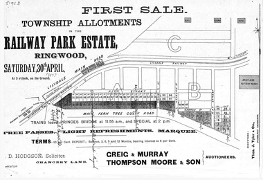
Flyer, Subdivision advertisement - Railway Park Estate, Ringwood, Victoria - circa 1887
... Subdivision advertisement - Railway Park Estate, Ringwood... of advertisement for auction sale of township allotments in Railway Park ...Photocopy of advertisement for auction sale of township allotments in Railway Park Estate, Ringwood, on Saturday 30th April (1887?), with terms of sale and location map.Subdivision map includes Pitt Street and Main Ferntree Gully Road (later Bedford Road). (Agents) Greig & Murray, Thompson Moore & Son, Auctioneers. -
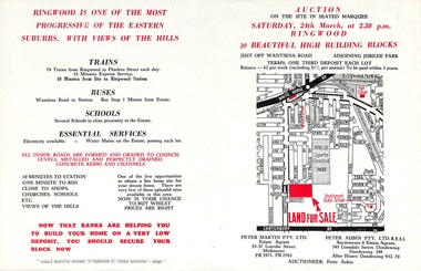 Ringwood and District Historical Society
Flyer, Land Auction Advertisement adjoining Jubilee Park, Ringwood, Victoria - 1956
... Land Auction Advertisement adjoining Jubilee Park, Ringwood... adjoining Jubilee Park, Ringwood, Victoria - 1956 Flyer ...Folded double-sided brochure advertising residential land sale auction on Saturday 24th March (1956), with locality map and subdivision layout, terms of sale, and summary of local features and services. Subdivision includes Reilly Street Ringwood, and Philip Street, Daisy Street, and Lorienne Street Heathmont. Surveyors - Messrs Little and Brosnan. Agents in Conjunction - Peter Martin Pty. Ltd., Estate Agents, 55-57 Latrobe Street, Melbourne (Phone) FB 3571, FB 2783, and Peter Aubin Pty. Ltd. R.E.S.I., Auctioneers & Estate Agents, 345 Lonsdale Street, Dandenong (Phone) Dandenong 340, After Hours, Dandenong 932, 70. -
 Ringwood and District Historical Society
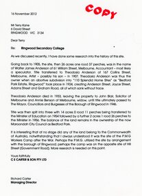
Document - Folder, Brief history of the Ringwood Secondary College site in Bedford Road, Ringwood, Victoria, since 1905 and subdivision in 1924
Terry Kane and Richard Carter were the authors of the short historyType written notes and plans pertaining to the land titles and history of the Ringwood Secondary College site from 1905, prior to the land being sold by the Borough of Ringwood in 1954 to the Education Department. Transcript of covering letter from Richard Carter to Mr T Kane dated 16 November 2012 - "Re: Ringwood Secondary College As we discussed recently, I have done some research into the history of the site. Going back to 1905, the site, then 26 acres one rood 37 perches, was in the name of Walter James Anderson of 61 William Street, Melbourne, Accountant - most likely a speculator. Title transferred to Theodosia Anderson of 167 Collins Street, Melbourne, Artist - possibly his son - In 1907. Theodosia Anderson was thus the owner when on abortive subdivision Into "110 Splendid Home Sites" as "Bedford Park Estate, Ringwood" took place In 1924, creating Anderson Street, Joyce Street, Adams Street and Graham Road, all of which sank without trace. Theodosia Anderson died In 1933, leaving the property to John Blair, Solicitor of Melbourne and Annie Benson of Melbourne, widow, until title ultimately passed to The Mayor, Councillors and Burgesses of the Borough of Ringwood In 1946. Title was then spilt Into three with 14 acres 0 rood 11 perches being transferred to the Minister of Education on 1954 followed by a further 2 acres 1 rood 26 perches to the Minister In 1956. The balance of the land remains In the ownership of the now Maroondoh City Council as Bedford Park. It Is Interesting that at no stage did any of the land belong to the Commonwealth of Australia, notwithstanding that I always understood It was the site of the P.M.G. Workers Camp after the War. Perhaps the P.M.G. utilized the site by arrangement with the borough of Ringwood; perhaps the camp was on the opposite site of Hill Street (Government Road). More research Is needed on this point. Yours faithfully, CE CARTER & SON PTY LTD Richard Carter Managing Director" -
 Ringwood and District Historical Society
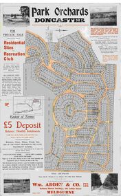
Map, Park Orchards Land Sale Advertisement, Doncaster, Victoria, Circa 1926
Large linen backed map of the Park Orchards subdivision for private sale of residential sites and recreation club, highlighting local facilities, services and layout of the estate. Surveyors - Tuxen & Miller, 34 Queen Street, Melbourne. Agents - Wm Addey & Co., Pty Ltd., National Mutual Buildings, 395 Collins Street, Melbourne, Phone F3906. Terms £5 deposit balance monthly installments of £1 with the residue at the end of five years. Subdivision includes Alva Avenue, Arundel Road, Aviemore Avenue, Berringa Road, Bowmore Avenue, Brucedale Crescent, Brympton Avenue, Camber Avenue, Cawdor Avenue, Colin Avenue, Corriedale Crescent, Craithie Avenue, Daintree Avenue, Dalry Avenue, Dirlton Crescent, Drayton Crescent, Elgin Crescent, Enfield Avenue, Ennismore Crescent, Euston Avenue, Feversham Avenue, Frogmore Crescent, Gosford Crescent, Granard Avenue, Hopetoun Road, Hylton Avenue (later Knees Road), Jura Avenue, Park Road. -
 Ringwood and District Historical Society
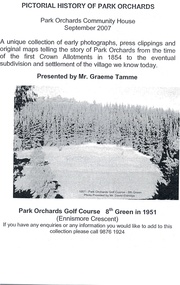
Memorabilia - Invitation, Pictorial History of Park Orchards Exhibition - Park Orchards, Victoria - 2007
... Pictorial History of Park Orchards Exhibition - Park... History of Park Orchards Exhibition - Park Orchards, Victoria ...Folder containing leaflet and flyer for the Pictorial History of Park Orchards exhibition by local resident, Graeme Tamme, at Park Orchards Community House, 8th & 9th September, 2007. Follow-up letter 16th January, 2008 from Graeme Tamme, to Richard Carter, past RDHS President. (Enclosures mentioned in letter not included in folder.) -
 Orbost & District Historical Society
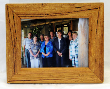
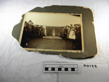
framed photograph, 14.4.2004
This photograph was taken on 14.4.2004 at the time of the visit to Orbost by the Governor of Victoria, John Landy.The Orbost Visitor Information Centre is situated in Forest Park on Nicholson Street. The centre is housed in the historic Slab Hut. The hut was an original family dwelling built in 1872, on a site approximately three kilometres upstream from the junction of the Buchan and Snowy Rivers. The Slab Hut is an Orbost Icon. It supports one part time manager and a team of dedicated volunteers.A coloured photograph in a wooden frame. A group of people stand in front of the Slab Hut (Orbost Information Centre) .On frame - NATURAL FEATURED HARDWOOD MADE BY 20.12.98 W. ASHLYN MARLO VIC.slab-hut-committee photograph -
 Ringwood and District Historical Society
Photograph, Official opening of Greenwood Park Kindergarten, Greenwood Avenue, Ringwood on 10th December 1955. Arrival of Lady Violet Brooks, wife of the Governor of Victoria Sir Dallas Brooks, being greeted by Mrs. Helen Austin"
Typed below photograph, "Official opening Greenwood Park Kindergarten, 10th December 1955. 1. Arrival Lady Violet Brooks, wife of the Governor of Victoria Sir Dallas Brooks, being greeted by Mrs. Helen Austin". -
 Ringwood and District Historical Society
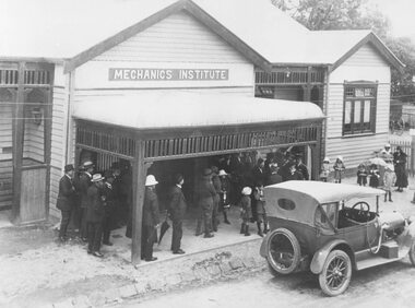
Photograph, Maroondah Highway Central, Ringwood. Mechanics Institute, Melbourne Street entrance - September, 1909
Black and white photograph (3 copies- 1 original and 2 copies)Typed below Photograph: "Mechanics Institute - Melbourne St. South. (Now demolished) Image shows a wooden building with sign above veranda reading "Mechanics Institute". Groups of men and children standing outside with car parked on roadway in front of building. Official opening by Premier of Victoria, Mr. John Murray. -
 Orbost & District Historical Society
newspaper clippings, April, May 1987
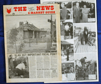
The Slab Hut (Orbost Visitor Information Centre) was opened on March 28, 1987. It was officially opened by Dr D. Caughey, the governor of Victoria. The Orbost Visitor Information Centre is situated in Forest Park on Nicholson Street. The centre is housed in the historic Slab Hut. The hut was an original family dwelling built in 1872, on a site approximately three kilometres upstream from the junction of the Buchan and Snowy Rivers. The Hut was removed from its original site around 1970, and stored until 1984 when the Shire Council approved the current site. It was restored and brought to life as a Tourist Information Centre in 1987.The Slab Hut is an icon of Orbost. These newspaper articles are contemporary records of the opening of this building.A selection of articles from The News and the Snowy River Mail. All relate to the opening of the Slab Hut, the Orbost Visitor Information Centre. They are photographs, information and the history of the Slab Hut.slab-hut-orbost newspaper-snowy-river-mail -
 Cheese World Museum
Photograph, Unknown photographer, The first mechanical milking machine public demonstration in Allansford district, 1905
The Percy Uebergang family lived at Tooram Park, Allansford from 1912 until 1992. Percy and Myrtle Uebergang's children were twins, Ray and Joyce born in 1926 who lived at Tooram Park until their deaths, Ray in 1986 and Joyce in 1992. Neither Ray nor Joyce married and following the death of her brother Joyce set up the Ray and Joyce Uebergang Foundation which supports the local community. This photograph is part of the collection of items given into the care of the Cheese World Museum. Uebergang catalogue No. Photograph tells the story of a special celebration marking the occssion of the demonstration of the first mechanical milking machine on the Ernst Uebergang property Briarwood at Cudgee Victoria. Ernst Uebergang is inside the shed. Reported in Warrnambool Standard 5 June 1905.Photo on badly damaged brown mount board. Image depicts LKG milking machine demonstration. Dignitories, farmers and children present. Two men are inside the shed with two cows. Written on back of photo 'LKG Milking Machine Lawrence Kennedy 1902/ Mr Ernst Uebergang inside shed.'uebergang, dairy industry, rural industry, food manufacture, machinery, lkg, cudgee, briarwood, milking machine, children, cows, dignitories, farmers, bucket -
 Cheese World Museum
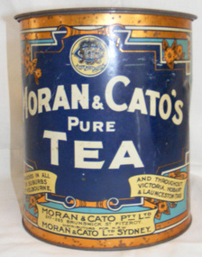
Tin, tea
This tea tin is part of the Uebergang Collection. The collection is the property of the 'Ray & Joyce Uebergang Foundation' and was held in store for several years before being transferred to the care of Warrnambool Cheese and Butter Factory Company Ltd's Cheese World Museum. The Uebergang family came from Silesia in 1848 and were early settlers in the Allansford area. The Uebergangs purchased Tooram Park in 1912 and lived there until it was sold following the death of the last member of the family in 1994. The family often re-used, recycled and repaired items. The tea tin is an example of re-use. Moran & Cato was Dark blue cylindrical tin with push-on lid decorated with a bronze ring around the top and bottom for retail tea sales. The tin was sold by retail firm Moran & Cato and is decorated with their name in large white lettering on the front, and the address in scrolls at the bottom. The firm's logo/trade mark is featured in a circle at the top with a flower design each side. The logo/trade mark has the letters M & C intertwined and the company motto in a scroll below. The tin was designed to be used for storage once empty and is marked on the back with the word 'Cakes' in a cream scroll across the centre. The top half of this side is light blue and the bottom half dark blue.Trade mark: We Keep Troth Moran & Cato's Pure Tea/Branches in all suburbs of Melbourne and throughout Victoria, Hobart (Tas). At base: Moran & Cato Pty Ltd/277 Brunswick St/Fitzroy. Distributors for NSW. Moran & Cato Ltd Sydney. Reverse: Cakes On bottom: A24uebergang, tins, tea, moran & cato, recycling -
 Cheese World Museum
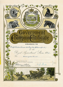
Certificate, Government Champion Certificate, 1951
Kraft-Walker Cheese Company commenced in Allansford in 1935 leasing the factory premises from Warrnambool Cheese and Butter Factory Company. Dairy companies entered competitions organised by the Dairy Industry Association and associated organisations and local agricultural societies to encourage improvement in products. Some of these awards are considered prestigious and highly regarded within the industry. The certificates were passed to Cheese World Museum by the factory management.This certificate was held by the factory management until transfer to Cheese World Museum. The certificate provides an insight into the dairy industry during the 1950s.Cream card certificate from Royal Agricultural Show has a plain line border on left, bottom and right side with inner border of green vine plant on left, top and right side. A sheaf of oats and a scene of haymaking complete the border design. The top of the certificate has the Department of Agriculture Victoria logo flanked by circular images of a sheep and cow on the left and a hen and horse on the right. The centre of the certificate has a gold shape overprinted with black.Government Champion Certificate/ Awarded to Kraft Walker Cheese Co Pty Ltd (Allansford) at the Royal Agricultural Show 1951/ for Champion Cheese/ Issued by direction of/Hon. the Minister for Agriculture/H A Mullett/ Director of Agriculture/ W J Park/ Judgesallansford, kraft walker cheese company, cheese manufacture, dairy awards, product awards, warrnambool cheese and butter factory company, kraft walker pty ltd, royal agricultural show, department of agriculture victoria, cheeses, cheese manufac, warrnambool cheese and butter