Showing 13848 items matching "party-line"
-
 Bendigo Military Museum
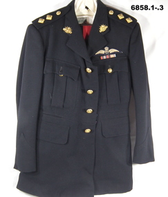
Uniform - MESS DRESS, OFFICERS, Snows, 1951
Refers to the service of "Lt. R. Baker" 5/13385..1) Jacket, black wool. Four front pockets. Rising Sun on Collars. Lieut. pips (2) on each epaulette. Four brass buttons on front. Button Motif - Australian Military Forces. On left chest are two ribbons, War medal 1939-45 and Australian Service Medal, and an RAAF Flying wings badge. .2) Trousers, black wool, Red stripe down outside of legs. Button fly, striped lining around waist line inside. Two side and one rear pocket. .3) Shirt - off white cotton, long sleeves, one breast pocket. .4) Cap - peaked black, red band, Rising Sun Badge. .5) Tie - black .6) .7) Shoes - pair of black leather, rubber soled shoes L & R.Inside jacket - “Lt. R. Baker 5/13385 2/11/51”ww2, post ww2, mess dress uniform, r. baker, passchendaele barracks trust -
 Northern District School of Nursing. Managed by Bendigo Historical Society Inc.
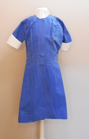
Uniform - Trainee Nurse Uniform
Northern District School of Nursing nurse's base uniform 1950s - 70s.Blue cotton uniform worn beneath white apron. The uniform is open at the front with eight button holes in right placket for buttons and shanks to attach. There are corresponding buttonholes on left side for closing, a small pocket at top left and a pocket at RHS of skirt. There is a small buttonhole at back of neck to attach white collar and white cuffs are attached to sleeves with two white buttons. The front has gathering from below the shoulders and the back top has an inverted pleat at centre. There is a white belt with two white buttons at one end attached with shanks and three sets of two button holes at the other end for closing. There is a white cap with frill and a line of blue braid above the frill indicating a third year trainee. There is a white apron with four buttonholes at the waist for closing and for the two shoulder straps.A white tag with Joy Lewis' in red is attached to all items. N.T.S in black marking pen is printed on back hem of neck. There are many black marking pen numbers and letters on the cap: NTS, BAS, 574, BH5, 530, 574 The apron has the name Lewis and figures 638 in black marking pen on inside of waist.nurses uniform, northern district school of nursing -
 Bendigo Historical Society Inc.
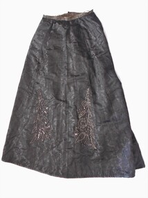
Clothing - GRAYDON COLLECTION: WOMEN'S BLACK EMBOSSED SILK SKIRT, 1870-1890
Clothing. Women's black embossed silk skirt. Part of two piece set(bodice 11410.1). A shaped skirt with 2.5 cm cotton fabric waistband with three hanging loops attached. Centre back opening (20cm) fastened at waist with two metal hooks and eyes. Two metal eyes on waistband for attaching to the bodice. The front of the skirt has two vertical sections of appliquéd decorative beading (38 cm X 5 cm). The hem of the skirt is edged with black satin binding. The skirt is fully lined with brown cotton fabric. At centre back below the opening is an internal pocket (40 cm X 8 cm) of lining fabric. Historical Notes: This bodice and skirt belonged to Elizabeth Graydon (nee Richardson). Photograph of Elizabeth wearing this outfit (11410.3). -
 Melbourne Tram Museum
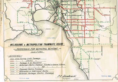
Drawing, Melbourne & Metropolitan Tramways Board (MMTB), "Melbourne and Metropolitan Tramways Board Proposals for General Scheme, c1923
Set of two copies of a drawing with a line back, titled "Melbourne and Metropolitan Tramways Board Proposals for General Scheme". Shows the proposed tram lines submitted to Parliament for the report into the General Scheme. Printed by Sands & McDougall Pty Ltd. Smaller print has been cut and folded for inclusion within the report (see item 2088) and has two punch holes on the side. Has been stamped "Per-Way file" in a number of places. Signed by J. P Strickland dated 27-8-1923. Larger print, original print size has "H. S. McComb" in ink in the top right hand corner. See Reg Item 2088 for actual report. See Reg item 3059 for a separate copy of the map.trams, tramways, mmtb, general scheme, tramways, development, parliament, brighton, railways, map -
 Melbourne Tram Museum
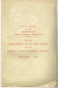
Document - Report, Metropolitan Town Planning Commission, "Metropolitan Town Planning Commission - Darling to Glen Waverley Railway - 1927", May. 1927
Report - 20 pages + 5 Maps stapled and then glued bound within a light green grey light card folder titled "Metropolitan Town Planning Commission - Special Report on the Development of the area serviced by the Darling to Glen Waverley Railway - 1927". Report looks the development that could be undertaken along the proposed Glen Waverley rail line, its town planning, Garden City type layouts, rail level crossings, new arterial roads, open spaces, financial arrangements, sewerage and water supply, zoning, legislation and conclusion. Dated 6/5/1927. Plans show possible garden city type layouts, arterial roads, possibilities within existing sub-divisions. Note that Mr. Strickland was a member of the Commission undertaking this work.Has in ink on the bottom edge "17th June 1919"trams, tramways, mmtb, tramways, development, town planning, glen waverley, darling -
 Melbourne Tram Museum
Document - Report, Melbourne & Metropolitan Tramways Board (MMTB), history of the cable tram system until its closure in 1940, Oct. 1940
Report - 6 quarto pages, typed, untitled. Dated Oct. 1940. Looks at the history of the cable tram system until its closure in 1940. Appears to have been drafted for a newspaper article as it quotes the Chairman "Mr Bell". Outlines the history of the system, the formation of the Melbourne Tramways Trust, its work and the work of the company, finances, loans, opening dates, construction and timing of the closure of the Bourke St route. Car set No. 1 - "might find its way into a museum" Notes the services of the long serving cable tram employees - Conductor G E Andrew from Clifton Hill, Conductor G. Bresnahan - Northcote, Gripman B. McMahan Clifton Hill and Conductor A. Ogden. Details the history of the Northcote line itself, Northcote Council, current employment conditions.trams, tramways, cable trams, closure, employees, conductors, gripmen, northcote, city of northcote, clifton hill, mto co, mtt -
 Melbourne Tram Museum
Document - Memorandum, Melbourne & Metropolitan Tramways Board (MMTB), Warships at Port Melbourne, Oct. 1934
HM & HMA Ships Sussex, Dunedin, Diomede, and Canberra at Princes Pier, Port Melbourne during Centenary Celebrations Saturday 20 October to Sunday 11 November 1934 1 - Handwritten note "Warships at Princes Pier Port Melbourne Sat 20th Oct to Sun 11th Nov" 2 - Handwritten note "Warships at Port Melbourne " - Insp Blyth's report on tramcar loadings for Sunday 11 November. 3 - Port Melbourne Cable Line - memo from DJ Davidson, Dist Traffic Superintendent SS to Mr Taylor at South Melbourne outlining running times for cable trams to Port Melbourne 4 - Handwritten table card 5 - Letters from Navy Office proving details of ship opening times during the Royal VisitNumerous inscriptions written in pencil and ink across most documentstrams, tramways, events, inspection, port melbourne, port melbourne depot, cable trams -
 Melbourne Tram Museum
Slide - Set of 4, Dave Menzies?, 19/04/1973 12:00:00 AM
Set of four colour slides of PCC car 1041 on its debut trip, but that broke down at the corner of Gertrude and Nicholson St. TMSV copy slides. Photographer unknown. Dated 19/4/1973. .1 - In Nicholson St with the Cable Tram winding house in the background. .2 - 1041 reversing and about to pass through the crossover. Has a W tram at the other end that has cleared the tram from the cross over shown in the first slide. .3 - has a W class tram at the rear - could be out of order. .4 - Being towed by W7 1001 in Queens Parade under the Reservoir railway line railway bridge. advertising Stegbar windows and Stott & Son Real Estate. See also Reg Item 6043 for other photos.Keith has written details on each slide including the date and the "TMSV" stamp.trams, tramways, gertrude st, new tramcars, winding houses, tram 1041, pcc class, tram 1001, w7 class, clifton hill -
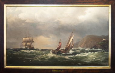 Mission to Seafarers Victoria
Painting - Oil painting, Madeline M.Ravenna Lewellin, Start Point Light, Devonshire, 1875
This painting was inspired by an original painting by Wilhelm Melby held at the National Gallery of Victoria. Melby is a Danish artist (1824-1882). It depicts a famous Devonshire coastal region famous now for its lighthouse and the pick up point for the pilot when entering waters approaching Dartmouth. The sailing vessels pre-date the construction of the famous lighthouse. Over the centuries the view would have been familiar to many sailors as they left or approached the English mainland and south coast ports in the English Channel. Madeline Mary Ravenna Lewellin (1854 – 24 November 1944) was born in Victoria to Dr John Henry Hill Lewellin, a physician, and Grace Elizabeth (née Danneby). She was one of five daughters, and the family lived in Prahran. Lewellin's brother, Captain Herbert Gordon Hill Lewellin, was a commander in the P. and O. fleet (apprentice on the Romanoff, Lieutenant RNR on the HMS Arethusa in 1899, RMS Mongolia in 1913 sunk in 1917, Naldera in 1920). She studied painting at the National Gallery School in 1879 under Eugene von Guerard. She's also known for collecting and painting specimens, and became a member of the Field Naturalists Club of Victoria in 1885. In 1884 she won a silver medal for her studies of fungi. She collected plants for Australian botanist Ferdinand von Mueller, and the variety of Dicrastylis lewellinii (Purple sand-sage) is named after her. Miss Lewellin, who had a love of the sea and ships as subject matter is listed in 1910 as a donor as a 10/6 member donating to the motor launch fund and in 1918 as a working member of the Ladies Harbour Lights Guild which involved regular volunteer shifts at the Mission to Seamen on canteen and other duties.Marine art, Maritime artThis oil painting has a dark polished wood and gold leaf slip. The painting depicts two masted boats. The choppy sea takes up the lower-third of the painting, and the other two-thirds of the image of made up of stormy grey clouds. A rocky cliff face can be seen on the right-hand side of the painting. A small church can be seen on the hillside. The ship on the left third of the painting sits on the horizon line of the sea. The centre ship with two masts appears to be leaning to the right and its deck is exposed to the viewer showing four men attempting to handle the masts and rigging. The left-hand ship with three masts is surrounded by two grey distant silhouetted mast ships. There are three seagulls at the upper left-centre of the image. There are another three gulls down on the lower-left of the image. Front: ENGRAVED PLAQUE: Start Point Light. Devonshire. SIGNATURE: After W. Melby / M.M.R Lewellin. 1875. Reverse: IN BLACK MARKER PEN: * Hang from two points * WHITE STICKER WITH CONSERVATOR DETAILS: Art Conservation Frames / 118 Bridport Street, Albert Park, VIC, 3206 / 9696 9066 / artconservationframers.com.aupainting, ships, mast, church, sea, storm, oil painting, seagulls, madeline r. lewellin, artwork-paintings, ngv, wilhelm melby, eugene von guerard, botanist, rms mongolia, captain herbert gordon hill lewellin (1862-1935), paddy lewellin, reproduction -
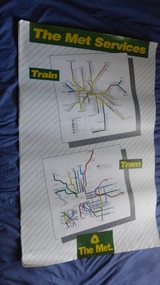 Melbourne Tram Museum
Poster, The Met, "The Met Services", mid 1990's
Poster - full colour on semi gloss paper titled "The Met Services" showing in a diagrammatic form the Melbourne tram and rail routes. For the tram section, (similar to Reg Item 509), shows major street names, route numbers, principal suburbs, terminal names, central area (pre Docklands, post light rail to St Kilda and Port Melbourne) and ticket zones. The rail map section shows the Neighbourhood ticket zones, the rail line via Altona (the direct route is not shown) and shows the St Kilda and Port Melbourne light rail lines. Has The Met logo and the Public Transport Corporation names on the bottom. Mid 1990's, Batman Ave still shown. See also Reg Items 696 and 696 for maps of the time.trams, tramways, melbourne, tramways, tram routes, railways, map, posters, tickets, neighbourhood tickets -
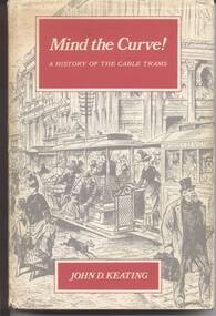 Melbourne Tram Museum
Book, John D Keating, "Mind the Curve", 1970
Hard bound book, 172 pages, including end covers, 10 sections, title "Mind the Curve", with subtitle "A history of the Cable Trams", stitch bound to hard red Rexene covers with gold block title on the spine only. Dust cover has the title, author, drawing of Bourke St and details of the book and author on the returns. Written by John D Keating, published by the Melbourne University Press in 1970. Has index, acknowledgements, table of contents, list of illustrations and references Looks at the establishment, construction, operation and demise of the cable tram system in Melbourne. Provides location details of the engines houses, tramcars, ticketing, management, politics, the Northcote line and the workers. 2nd copy added from the collection of Colin Jones - title page signed by John Keating - see image i5/trams, tramways, melbourne, mmtb, cable trams, mto co, horse trams -
 Melbourne Tram Museum
Document - Report, Parliament of Victoria, "Transcript of Evidence Public Works Committee - Melbourne - East Burwood Tramway Enquiry", 1974 - 1975
Foolscap duplicated reports or ""Transcript of Evidence Public Works Committee - Melbourne - 4 Dec. 1974 - East Preston Burwood Enquiry". Each set stapled in top left hand corner. 689.1 - First day - 54 pages - 4/12/1974 689.2 - Second day - 80 pages - 24/3/1975 - last page loose. 689.3 - 3rd day - 46 pages - 2/7/1975 689.4 - Report from the Parliamentary Public Works Committee - 7/6/1977 - 21 pages 689.5 - Newspaper cutting from The Sun, 18/1/1975, advertising the Committee and calling for submissions. 689.6 - Quarto sheet - Burwood Tram line extensions listing possible stops. See Reg Item 1354 for a report dated 7/7/1976.Each set of documents stamped "AETA" and "AETA Public Transport Committee" on the front sheet.trams, tramways, east burwood, victorian government, parliament, enquiries -
 Melbourne Tram Museum
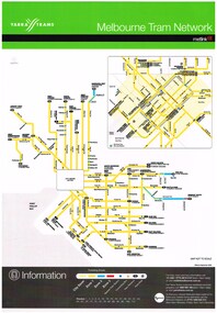
Poster, Yarra Trams, "Melbourne Tram Network", Sep. 2006
Full colour poster, A3 size, printed on laminated sheet - titled "Melbourne Tram Network. Shows a diagrammatic layout of the Melbourne tram system, shows zones (3 zones), CBD, tram terminuses, train station, park and ride locations. Has the Yarra Trams and Metlink logos. Provides contact information including a website. Notes where Metcards are available. Two copies held. Vertical format of Reg Item 719. Dated Effective September 2006. 720.2 - dated Jan. 2005 - shows the Vermont South extension under construction - see image i2. Item added 11-8-2016. 720.3 - undated - prior to Vermont South opened in 2005 - has route 112 and docklands tram line - c2004. Does not have a Yarra Trams logo.trams, tramways, yarra trams, metlink, maps, metcard, vermont south -
 Bendigo Historical Society Inc.
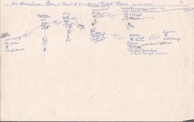
Document - MINING REPORTS - CALEB THOMAS PLANS
(a) Copy of Caleb Thomas Plan - Sheet No VI (774) on the New Chum Line dated 4/12/1885. Plan shows the new St Mungo, Duchess Tribute, South Devonshire, Alberts Shaft, Duchess of Edinburgh, United Devonshire (later W. V. Devonshire), Princess Alexandra (later The United Devonshire) and the Ext'd St Mungo. (b) Sheet No VA (775) dated 30/5/1885. Eaglehawk District. Mines mentioned are: Phoenix Coy, Unicorn Coy Lease, Unicorn Shaft, Sth St Mungo, St Mungo Coy and the Lady Barkly. Also some numbered, unnamed shafts. Plans mentions shaft number, no of compartments and distance in yards and feet between each mine. Document is part of the Albert Richardson Collection. document, gold, mining reports, mining reports, caleb thomas plans, st mungo, duchess tribute, south devonshire, alberts shaft, duchess of edinburgh, united devonshire (later w. v. devonshire), princess alexandra (later the united devonshire), ext'd st mungo, phoenix coy, unicorn co lease, unicorn shaft, sth st mungo, st mungo coy, lady barkly -
 Bacchus Marsh & District Historical Society
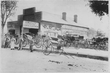
Photograph, H.Moffatt Coachbuilder General Blacksmith Main Street Bacchus Marsh
H. Moffatt, blacksmith, opened new brick premises in 1899 on the site of a similar building burnt down the previous year. He continued to operate as a coachbuilder and blacksmith on this site until 1927 when he retired. Since then, the premises have been used for coffin making, a hardware store, furniture store, bathroom supplies among other things. It is now operating as Lola's Restaurant.Black and white photographic print. Dating from the early 1900s, this photograph is of a substantial brick building opened in 1899 by Mr H. Moffatt at 110 Main Street on the site of a similar building which burnt down in 1898. A sign at the front reads: H.MOFFATT COACHBUILDER GENERAL BLACKSMITH. A number of horse-drawn carriages, two and four-wheeled, stand on the footpath, roadway and on the vacant block next door. The road appears to be unmade and is separated from the elevated footpath by barge boards. Advertising signs line the side wall of the building. Four men stand on the road, three wearing the leather apron worn by blacksmiths, one wearing a long white apron as was often worn by shop assistants. Horse droppings, a common sight in those days, can be seen on the roadway. shops bacchus marsh vic., main street bacchus marsh vic., h. moffatt, coachbuilders, general blacksmiths -
 Port Melbourne Historical & Preservation Society
Souvenir - Souvenir flag Spirit of Tasmania, 23 Oct 2022
The red souvenir flag with the Spirit of Tasmania name and TT Line logo was made to commemorate the Bass Strait ferry's last sailing from Melbourne. In July 1985, the Spirit of Tasmania 1 made her first voyage to Melbourne and from that date ferried passengers, vehicles and cargo to and from Devonport, Tasmania. Many passenger ferries have been employed in the Bass Strait passenger service since the 1840's. Ships using preceding the Spirt of Tasmania include the Taroona, Princess of Tasmania and the Abel Tasman. The flag was one of many distributed to the crowds gathered on the foreshore to farewell the ship. With her sister ship, Spirit of Tasmania 2, the red and white ferries had been a familiar sight at Station Pier, Port Melbourne for more than three decades.piers and wharves - station pier, spirit of tasmania, tt-line -
 Kew Historical Society Inc
Photograph - Country Roads Board and Denmark Street Baby Health Centre, Ron Setford, 1961
Ron Setford and his wife Grace Setford lived in Tanner Avenue, East Kew, from c.1946 to c.1995. A keen photographer, he recorded the changing face of Kew over a 20 year period. Apart from 30 photographs of built structures and places in Kew dating from 1960 and 1961, 145 of his 35mm colour slides chronicle the development of the Eastern Freeway through the Yarra Valley over a five year period from c.1972 to c.1977. This important collection was donated to the Society by his granddaughter in 2025.This collection of 175 35mm slides is of local and statewide significance, owing to its subject matter, particularly the major development of road transport infrastructure during the 1970s with the construction of the Eastern Freeway. The photographer also took care to annotate and date most of his slides which enable the researcher to pinpoint temporal and spatial locations.A photograph providing a visual contrast of the pre and post-World War II architectural styles of the Denmark Street Baby Health Centre and two of the Country Roads Board office buildings. Each was built on part of the land fronting the Kew branch line. In May 1939, the Railway Commissioners agreed to lease a site at the Kew Railway Station for a Baby Health Centre. The single-storey cream brick building was designed by Roland Chipperfield. The Country Roads Board (1913–83), later renamed VicRoads, transferred its headquarters from the Royal Exhibition Building to Kew in 1961, following the completion of two modernist eight-storey office towers in 1960. The VicRoads buildings were closed in 2024, and there is ongoing debate about what replaces them.Nilron setford, photographs -- kew (vic.) -- 1960s, country roads board, vicroads, denmark street -- kew (vic.), denmark street baby health centre -
 Bendigo Historical Society Inc.
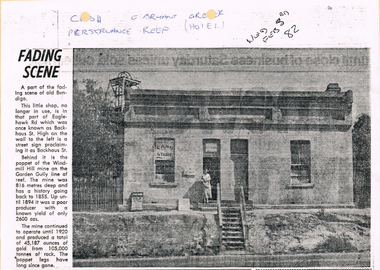
Newspaper - LONG GULLY HISTORY GROUP COLLECTION: E BRYANT - GROCER
BHS CollectionCopy of a newspaper article titled Fading Scene. Photo shows a building with a stairway leading down to the road in front of it and a lady standing in the doorway. One window has Cash Store printed on it and there are two placards leaning on the building to the left of the lady. Each side of the building are shrubs and picket fence. In the background to the left is the poppet of the Windmill Hill Mine on the Garden Gully line of reef. It is in that part of Eaglehawk Rd which was once known as Backhaus St. High on the wall to the left is a street sign proclaiming it as Backhaus St. Written above the photo is C-sh, E Bryant, Gro-er (there are holes through the words), Perseverance Reef (Hotel). Wed Feb 3rd 82. Article is mounted on yellow card which is mounted on purple card and laminated.bendigo, history, long gully history group, the long gully history group - e bryant - grocer, windmill hill mine, garden gully line of reef, e bryant, perservance reef (hotel) -
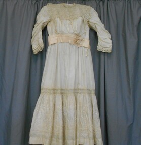 Bendigo Historical Society Inc.
Clothing - CREAM EMBROIDERED SILK AND LACE GIRLS DRESS, Late 1800's
Beautiful soft cream silk dress, with a random silk embroidered three petal flower over the fabric. Round neckline with overlaid square yoke of embroidered lace on a net background. Two 7cm wide bands of the lace are gathered over the shoulder armhole edge. These frills, and the scalloped edges of the front and back lace yoke are trimmed with 4 cm long decorative silk tassels.(one missing). Long sleeves, tapered in at the wrist are trimmed at the wrist with a 4.5cm wide band of lace, part of which is threadedwith two rows ofsoft pink silk ribbon insertion. Soft pink silk, folded into three 2.5cm tucks-overall width 6cm trim the high waistline, with a 7cm diameter rosette at the left front, and a bow(?), and tails, trimming the back waistline. This is severely damaged. Four metal hook and loops fasten the back lace collar, and nine metal hooks and eyes fasten the bodice. Bodice and sleeves are fully lined. Bodice is boned with thirteen 12-4 cm long ''bones''. Skirt is in two tiers; Top is 38cm deep, and made from the plain embroidered silk. A 5cm deep band of lace, with scalloped edges then joins the 36 cm deep ;lower panel of beautifully embroidery and pulled threadwork. Hem is faced, and finished or hemmed with french knots. Dress , which is hand stitched is fully lined with cotton. The lower 36 cm deep tier of the underskirt is trimmed with three .5cm tucks, and two 8cm bands of cutwork lace in a floral and geometric pattern. An oval shaped pocket is sewn into the front of the ''petticoat'' lining. This pocket contained some plant material, included in attached bag.costume, children's, cream embroidered silk and lace dress -
 Ballarat Tramway Museum
Photograph - Colour Photograph/s, 23/11/1962 12:00:00 AM
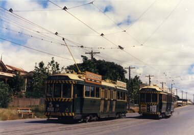
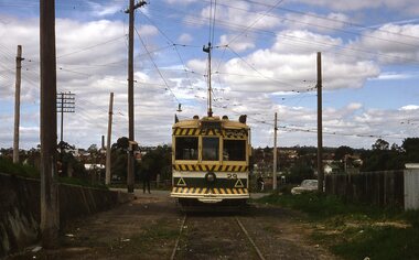
967.1 - Colour postcard size print of SEC Bendigo trams 4 and 17 at a crossing Loop on the Eaglehawk line. Photo dated 21.11.1962. Printed on AGFA paper. Both trams fitted with dash canopy lighting, but no large white strip under the driver's windows. 17 showing destination of "Eaglehawk", has two SEC ads on the side re Electric Cook and a White Horse whiskey ad on front panel. Tram 4 showing destination of "Quarry Hill", has two ad panels on roof and two ads on front panel including one Cohn's' Drinks. 967.2 - Colour postcard size print of SEC Bendigo tram 26 in Mitchell St. crossing Hargreaves St. heading for Charing Cross. Photo dated 21.11.1962. Printed on AGFA paper. Trams fitted with dash canopy lighting, but no large white strip under the driver's windows. Has two roof ads and one ad on rear drivers panel. In background of photo are the buildings along Mitchell St. looking down along Mitchell St and into View St. Has Plaza theatre sign in photo above tram. On right hand side, is a van marked "Carrier M. Slattery". Tram has destination of "Quarry Hill" in rear box. 967.3 - Colour postcard size print of SEC Bendigo tram 19 on the North Bendigo line. Photo dated 21.11.1962. Printed on AGFA paper. Trams fitted with dash canopy lighting, but no large white strip under the driver's windows. Has destination "Nth Bendigo" and SEC roof ads and drivers panel ad for Briquettes.On rear top left hand corner "21.11.62" in very wavy handwriting typical of an aged person.bendigo, eaglehawk, mitchell st., north bendigo, tram 4, tram 17, tram 26, tram 19 -
 Ballarat Tramway Museum
Photograph - Digital image Set of 20, 1971-72
Set of 20 digital images of Bendigo Tramways, 1972 at or before closure while on a tram tour by Stuart Lodington. .1 - No. 29 at the North Bendigo terminus .2 - No. 29 just past the Bendigo end of the double track in High St Eaglehawk, with a BP dealer in the background. .3 - Night photo of No. 18 at a terminus, showing "Eaglehawk" .4 - ditto .5 - Night photo of No. 24 at Eaglehawk with Leo A Hughes Photographer in the background. The Tram has "Johnnie Walker whiskey" roof adverts. .6 - No. 29 outbound in Thunder St with a train passing over the bridge in the background. .7 - view from the front window of a tram on the Eaglehawk line with a large "display event float" in the foreground and tram approaching a crossing loop. .8 - No. 29 at North Bendigo .9 - view of High St Eaglehawk looking east from the terminus, showing the track and centre poles. .10 - No. 29 outbound on the North Bendigo line turning from either Nolan St or Caledonia St, running a special. .11 - No. 7 departing North Bendigo for Golden Square. .12 - No. 3 and 18 at Charing Cross. No. 3 has two SEC roof Advertisements .13 - No. 7 at North Bendigo with the trolley pole being reversed. .14 - No. 24 at Quarry Hill with Northern Terrazzo in the background with the driver alongside .15 - No. 7 and No.6 at Charing Cross with the Beehive buildings in the background. .16 - No. 7 at North Bendigo terminus .17 - ditto .18 - No. 24 at Quarry Hill with Northern Terrazzo in the background with the conductor alongside. .19 - ditto .20 - No. 26 and other bogie tram in View St near Charing Cross with the Armstrong Tyre Service building and signs for Cohn's Drinks and T&G in the view.trams, tramways, bendigo, eaglehawk, quarry hill, golden square, depot, north bendigo, charing cross, tram 29, tram 18, tram 24, tram 3, tram 7, tram 6, tram 26 -
 Brighton Historical Society
Clothing - Riding habit, 1910s-20s
This item is from the "Barone" Collection. "Barone" (also known as "Seaview") was a stately Brighton home built at 9 Moule Avenue prior to 1855 and demolished in 1986. The house's residents included Edward Elgin Browne (during 1859-72), a Melbourne tea merchant, and the family and descendants of retired Scottish Army captain Archibald Black (during the period 1880-1970). Its neighbors included “St Ninians” owned by the Ward- Cole family, “Seacombe” owned by the Moule family, and the home of James Grahame and his family. The items in the "Barone" collection were largely donated by two of the house's later owners, Mrs Doris Halkyard and Mrs Brian Brandt.An English-made “Busvine” black wool herringbone twill riding habit comprising jacket and safety skirt, (jodhpurs missing) from late 1800’s to early 1900’s. The jacket (.1) features a black short pile silk velvet inset notched lapel collar secured with a single button at the apex of the waist and a single button near the collar for use in inclement weather. The sleeves join the bodice high on the shoulder with a full cut head to the sleeve and a tapered curved shape to the hand. The sleeve secures at the wrist with four black buttons. From the waist the jacket flares over the hip through princess line shaping and finishes with a curved front on either side. The seams of the shaping panels intersect single functional flapped besom pockets on either front panel. The back of the jacket features a centre back seam and two princess-line shaping seams that finish in a double vent on either side of the centre back. The jacket length would have finished approximately just below the bottom of the wearer. The apron fronted safety skirt (.2) secures from the waist at the front of the left thigh with five buttons. Over the wearers, right leg the skirt shapes to accommodate the rider’s right knee whilst sitting sidesaddle with her legs on the horses left flank. The base of the skirt has an elastic strap, which hooks around the rider’s leg to reduce the danger of the rider’s skirt become tangled, should the rider become un-seated. When the riders is not mounted the skirt can be secured with a button around the body to provide additional modesty as well as assist walking without the skirt dragging on the ground.Jacket: Manufacturer's label “Busvine, By serial appointment to Her Majesty The Queen, 4 Brook Street W.” Owner label “Doreen Wright” this label appears far more modern than the manufacturers label. Skirt: Manufacture's label: “J. Busvine and Co, 4 Brook Street, London W." In handwriting “Miss Wingfield” Manufacturers label: Busvines Patent Safety Skirt, protected by two separate patents. 4 Brooks St London West.barone, riding habit, j. busvine and co, seaview, brighton -
 Melbourne Tram Museum
Document - Report, Melbourne & Metropolitan Tramways Board (MMTB), "Interim Report - Nicholson Street Safety Bars", 1978c, 1973
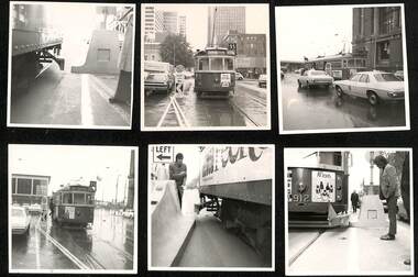
Report and photographs of various mechanisms to identify and check clearances for Safety Zones on tramways. .1 - Report - 4 pages stapled in top left hand corner - titled "Interim Report - Nicholson Street Safety Bars", dated 20/6/1978 signed by R. G. Vanselow. Describes the work involved in providing a type of "jiggle bars" leading up to the safety zone. Many photographs of the various types of safety zone marks were included within the folder. The photos of 912 are related to the clearance testing carried out during 1973 for the Z class. See also Reg Item 480? .2 - tram 912 fitted with a wooden device to measure clearances - with a concrete safety zone being checked. .3 - tram 1040 in Bourke St with a Safety Zone sign on the left - King St? .4 - tram and traffic at the Bourke St terminus. .5 - not used. .6 - tram 1000 at ditto on a wet day .7 - as for .2 .8 - ditto .9 - ditto .10 - side on view of W2 447 with a concrete prow fitted with a set of flashing lights. .11 - to .15 - series of large prints of enlarged 35mm negatives of night testing of safety zone sign taken at South Melbourne Depot and in St Kilda Road. .16 Bourke St - looking west at Russell St? with caption "prow replacing type 2 (Hairpin sign) with both original (white) and new MCC (Yellow) line marking on approach". .17 - Bourke St - looking west at Kings St and caption "Prow replacing type 2 (Hairpin sign) with original line marking on approach. .16 and .17 taken on Polaroid Instamatic cameras.Some of the photos have captions written on the rear.trams, tramways, tram stops, bourke st, safety zone, testing, z class, safety, tram 912, tram 1040, tram 1000, tram 447 -
 Ballarat Tramway Museum
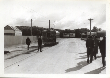
Photograph - Black & White Photograph/s - set of 32, Eldon Hogan, 4/06/1965 12:00:00 AM
Yields information about a 1924 Jelbart Engine manufacturing display in Sturt St and the street scene and peoples clothing at the time.Set of 32 black and white photographs of an Association of Railway Enthusiasts tour to Bendigo and trams 4/7/1965. The photos are not necessarily in photographic order. .1 - 30 on the Eaglehawk terminal track, beyond the normal terminus. .2 - 30 & 29 High St Eaglehawk. .3 - ditto with a poppet head in the background. .4 - 30 at one of the crossing loops .5 - 30 at Eaglehawk terminus extension .6 - ditto. .7 - ditto .8 - cleaning out the track .9 - showing the location of the track at Eaglehawk terminus and its extension .10 - cleaning out track .11 - a portable shed adjacent to the track .12 - A view of the two Birneys travelling in the empty country. .13 - ditto .14 - 19 and 18 at Golden Square .15 - Bendigo tram depot - creek crossing .16 - Scrubber at the depot .17 - 28 and 19 at the North Bendigo terminus .18 - 18 and 30 on the Golden Sq line .19 - 28 and 19 at the North Bendigo terminus .20 - ditto. .21 - 28 and 19 near the depot entry. .22 - 28 and 30 Pall Mall .23 - 28 at North Bendigo .24 - 17 and 19 and 6 at Quarry Hill .25 - 28 and 30 Mitchell St .26 - 19, 6 and 21 Quarry Hill .27 - 19 and 6 Quarry Hill .28 - 28 and 6 at the depot entry .29 - ditto .30 - 18 and 30, Golden Sq line .31 - 25 at depot .32 - 6 and 19 Charing Cross. Photographer Eldon Hogan. Printed on Kodak Paper .33 - roll of negatives of some of the above photos - stored in box 83 as well. trams, tramways, are, bendigo, eaglehawk, quarry hill, golden square, north bendigo, tram 30, tram 29, tram 28, tram 6, tram 19, tram 25, tram 17, tram 18 -
 Bendigo Historical Society Inc.
Photograph - VIEWS OF BENDIGO: COPIES OF 52 PHOTOS, 1850 - 1900
Copies of Photographs from - Views of Bendigo by Nicholas Caire Originals in Box 13 No.1 Sandhurst east/ City Reserve x 2 No 2 New Chum Line of Reef No 3 Sandhurst to North from top of Masonic Hall No.4 Hustler's Line of Reef No.5 Battery of stampers for crushing quartz x 2 No.6 View Sandhurst from top of Masonic Hall x 2 No.7 Excavation Quartz Reef, Ironbark Hill. No 8 St. Paul's Church. No.9 View Camp Reserve from Court House. No.10 View of Nth. Old Chum. No.11 View Camp Hill near the Lodge x 2 No.12 Garden Gully. No.13 Shamrock Hotel, Sandhurst. No.14 View from Court House, east end Pall Mall. No.15 Wesleyan Church, Golden Square x 2 No.16 Savings Bank, Sandhurst No.17 Bendigo District Hospital. No.18 Interior Wesleyan Church x 2 No.19 View Golden Square township. No.20 The Town Hall, Sandhurst. No 21 The City Hotel,Sandhurst. No 22 Pall Mall Sandhurst, No 23 Sandhurst City Market No 24 Pall Mall looking west x 2 No 25 Camp Hill x 2 No 26 Charing Cross No 27 View Sandhurst. x 2 No 28 Long Gully. No 29 Railway station and sheds No 30 Cemetery Back Ck. No 31 Kock's Pioneer Quartz Crushing Plant Long Gully. No 32 Masonic Hall. No 33 Bendigo Benevolent Asylum. No 34 Bendigo Flat. No 35 Old Chum Hill x 2 No 36 New Chum Gully No 37 Township of Eaglehawk No 38 From St Paul's tower looking west No 39 Tunnel Big Hill. No 40 From St Paul's tower looking south x 2 No 41 From St Paul's tower looking eastward x 2 No 42 From St Paul's tower looking north west x 2 No 43 Great Extended Hustlers Quartz Mining Claim No 44 Big Hill Rail line x 2 No 45 From St Paul's tower looking westward x 2 No 46 From St Paul's tower looking north west No 47 Big Hill Ranges Buick. x 2 No 48 St.Paul's Tower x 2 No 49 Eaglehawk township. No 50 Mitchell Street No 51 Botanical gardens, White Hills x 2 No 52 View Point, Sandhurst. .N.J. Caire.place, bendigo, bendigo area., views of bendigo. -
 Bendigo Historical Society Inc.
Document - Michele Matthews collection - paperwork and reports for re-zoning of Maiden Gully (1993 - 1996). Residents opposed the re-zoning as they had purchased land as "bush blocks", 25/02/2025
documents for Maiden Gully Sewerage SchemeMichele Matthews collection - paperwork and reports for re-zoning of Maiden Gully (1993 - 1996). Residents opposed the re-zoning as they had purchased land as "bush blocks" Coliban water Annual report 1993/94 21/12/1994 Maiden Gully Development Committee - newsletter No 1 - cttee met with representatives of Coliban Water Caliban Water information Bulletin January 1995 - Maiden Gully Sewerage Scheme 22/02/1995 Maiden Gully Development Committee - newsletter No 2 - cttee activities re the planned sewerage scheme 27/03/1995 - Coliban Water letter to WR & MS Matthews, owners 3 Clay Gully Court (Lot 56 LP 212245) undated - Maiden Gully Neighborhood Sewerage Schemes - Robin Hill Estate Scheme (cost allocation to property owners 21/04/1995 five-page letter of objection/complaint from WR & MS Matthews, owners 3 Clay Gully Court, re costs allocated against their property (Lot 56 LP 212245) 16/06/1995 five-page response from Coliban Water to WR & MS Matthews, owners 3 Clay Gully Court; regarding the outcome of their objection to the sewerage scheme 22/08/1995 letter from WR & MS Matthews, to resident re the results of their objections (and consequent concessions) from Coliban Water re the Robin Hill Estate Sept 1995 Maiden Gully Structure Plan, prepared by TEA planners & Planning Australia Consultants; provides a structure plan, for the Rural City of Marong, the propose future development of the Maiden Gully area Greater Bendigo Planning Scheme - Amendment L43 - Maiden Gully Township: * undated and author unstated - Maiden Gully questions sheet for residents re the proposed Maiden Gully Structure Plan - seven questions and answers * Fauna species - observed /recorded site 6; Maiden Gully (off Pioneer drive) * Explanatory report, three pages * 1/11/1995 Notice of Amendment to a Planning Scheme * Greater Bendigo Planning Scheme, Chapter 6, Amendment L43 (five pages) December 1995 Coliban Water "In the Pipe line", Maiden Gully Region Community Newsletter No 2 - Halfway mark for Sewerage Scheme March 1996 Coliban Water "In the Pipe line", Maiden Gully Region Community Newsletter No 3 - Home stretch for new sewer scheme May 1996 Coliban Water "In the Pipe line", Maiden Gully Region Community Newsletter No 4 - New sewerage scheme comes in well under budget Undated - Maiden Gully Township - Amendment L43 - Panel Hearing report (31 pages) maiden gully, sewerage scheme -
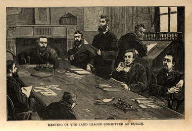 Ballarat and District Irish Association
Image, Land League Committee Meeting, Dublin, 1864
The Irish National Land League (Irish: Conradh na Talún) was an Irish political organisation of the late 19th century which sought to help poor tenant farmers. Its primary aim was to abolish landlordism in Ireland and enable tenant farmers to own the land they worked on. The period of the Land League's agitation is known as the Land War. Within decades of the league's foundation, through the efforts of William O'Brien and George Wyndham (a descendant of Lord Edward FitzGerald), the 1902 Land Conference produced the Land (Purchase) Act 1903 which allowed Irish tenant farmers buy out their freeholds with UK government loans over 68 years through the Land Commission (an arrangement that has never been possible in Britain itself). For agricultural labourers, D.D. Sheehan and the Irish Land and Labour Association secured their demands from the Liberal government elected in 1905 to pass the Labourers (Ireland) Act 1906, and the Labourers (Ireland) Act 1911, which paid County Councils to build over 40,000 new rural cottages, each on an acre of land. By 1914, 75% of occupiers were buying out their landlords, mostly under the two Acts. In all, under the pre-UK Land Acts over 316,000 tenants purchased their holdings amounting to 15 million acres (61,000 km2) out of a total of 20 million acres (81,000 km2) in the country. Sometimes the holdings were described as "uneconomic", but the overall sense of social justice was undeniable. (http://en.wikipedia.org/wiki/Irish_National_Land_League, accessed 21 January 2014) The Irish National Land League was founded at the Imperial Hotel in Castlebar, the County town of Mayo, on 21 October 1879. At that meeting Charles Stewart Parnell was elected president of the league. Andrew Kettle, Michael Davitt, and Thomas Brennan were appointed as honorary secretaries. This united practically all the different strands of land agitation and tenant rights movements under a single organisation. The two aims of the Land League, as stated in the resolutions adopted in the meeting, were: ...first, to bring out a reduction of rack-rents; second, to facilitate the obtaining of the ownership of the soil by the occupiers. That the object of the League can be best attained by promoting organisation among the tenant-farmers; by defending those who may be threatened with eviction for refusing to pay unjust rents; by facilitating the working of the Bright clauses of the Irish Land Act during the winter; and by obtaining such reforms in the laws relating to land as will enable every tenant to become owner of his holding by paying a fair rent for a limited number of years. Charles Stewart Parnell, John Dillon, Michael Davitt, and others including Cal Lynn then went to America to raise funds for the League with spectacular results. Branches were also set up in Scotland, where the Crofters Party imitated the League and secured a reforming Act in 1886. The government had introduced the first ineffective Land Act in 1870, then the equally inadequate Acts of 1880 and 1881 followed. These established a Land Commission that started to reduce some rents. Parnell together with all of his party lieutenants, including Father Eugene Sheehy known as "the Land League priest", went into a bitter verbal offensive and were imprisoned in October 1881 under the Irish Coercion Act in Kilmainham Jail for "sabotaging the Land Act", from where the No-Rent Manifesto was issued, calling for a national tenant farmer rent strike which was partially followed. Although the League discouraged violence, agrarian crimes increased widely. Typically a rent strike would be followed by evictions by the police, or those tenants paying rent would be subject to a local boycott by League members. Where cases went to court, witnesses would change their stories, resulting in an unworkable legal system. This in turn led on to stronger criminal laws being passed that were described by the League as "Coercion Acts". The bitterness that developed helped Parnell later in his Home Rule campaign. Davitt's views were much more extreme, seeking to nationalise all land, as seen in his famous slogan: "The land of Ireland for the people of Ireland". Parnell aimed to harness the emotive element, but he and his party preferred for tenant farmers to become freeholders on the land they rented, instead of land being vested in "the people".(http://en.wikipedia.org/wiki/Irish_National_Land_League, accessed 21 January 2014)Image of a number of men sitting around a table. They are members of the Land League Committee during a meeting in Dublin.ballarat irish, land league, land league committee, dublin -
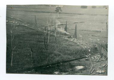 Orbost & District Historical Society
black and white photograph, 1916
This photograph shows the pile drivers at work in the construction of the viaduct across the Snowy River flats. The Snowy River Floodplain Railway Bridges, two sequential and exceptionally long and low timber railway bridges on the Snowy River floodplain just west of Orbost, were built in 1916, and provided the original terminus point for the Bairnsdale-Orbost railway. The bridges are 770 metres and 183 metres long respectively. The shorter bridge is of uniformly 4.57 metre timber-beam construction, and has a sweeping curve in its deck. The longer bridge has a combination of 4.57 metre and 6.1 metrespans, and two 3.66 metre spans. The bridges are constructed from 'Southern Mahogany', Eucalyptus Botryoides, which grew along the coast east of Bairnsdale. The Snowy floodplain bridges were initially built in the context of an early twentieth-century interest in American-style 'Developmental Railways', designed to open remote areas to closer settlement, even if that meant running at a loss. The line was closed in August 1987. (information from Victorian Heritage Database)This item is associated with the history of the Orbost-Bairnsdale railway line and therefore reflects the role that the rail line played in the social and economic history of Orbost.A black / white photograph of the farming flats at Orbost during the construction of the East Gippsland railway.orbost-railway east-gippsland-railway viaduct-orbost transport railway -
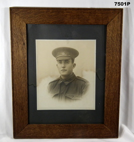 Bendigo Military Museum
Photograph - PHOTOGRAPH, FRAMED, WW1
Photograph Augustus Elliott Pegler. He had 4 years pre WW1 service in local unit Mildura. Enlisted No 967 in C Coy 38th BN on 29.1.1916 age 20 years 7 months. Embark for England 20.6.1916, embark for France 22.11.1916, appointed L/Cpl 3.3.1917, WIA 1st occasion 8.6.1917 GSW to Cheek, rejoin unit 5.8.1917, WIA 2nd occasion 17.10.1917 GSW to Abdomen severe, rejoin unit 28.3.1918, the Award of Mention in Despatches in December 1917, awarded The Military Medal 31.8.1918 during the attack on Inferno Trench leading his Lewis Gun Team, appointed Sgt 3.9.1918, embark for Australia 12.6.1919, discharged from the AIF 27.7.1919. (For reference - 38th Battalion in dog trench near Guillemont Farm during attack on Hindenburg Line, near Bony, Ref - Vol IV - CEW Bean - The AIF in France 1917 (Ref) Page 605 (58). Refer also Cat No 7502 Photograph - black and white portrait photograph of soldier in uniform, on paper. Mount - dark green cardboard. Frame - timber, mid brown stain colour, with glass front and cardboard backing.photograph, portrait, ww1, framed accessories -
 Eltham District Historical Society Inc
Photograph, Fay Bridge, EDHS Heritage Walk: Shillinglaw Farm, Eltham, 2 September 2023
On Saturday September 2, 2023, Russell Yeoman led a group of 22 society members and interested others on a walk following trhe bounadries of the original Shillingalw farm. Commencing at the corner of Panther Place and Library Place, we proceeded up to Shillinglaw Cafe then the Shillinglaw trees at the former Eltham Shire Office site then along Main Road to the fire station then throughh St Laurence Lane and uinder the railway line , along Diamond Street then return via the Diamond Creek trail behind Andrew Park. The actual farm boundary went past the creek and further up the hill. The original farm comprised lot 90 of Holloway’s 1851 subdivision of Little Eltham. Its area was 30 acres lying east of the Diamond Creek and north of Henry Street. A number of stops were made to look at maps and early photos illustrating the gradual reduction of the farm area and the early history of the railway and other community uses, that occupied parts of the site.fay bridge collection, 2023-09-02, activities, eltham, eltham district historical society, heritage excursion, shillinglaw farm