Showing 2281 items matching " damage"
-
 Eltham District Historical Society Inc
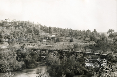
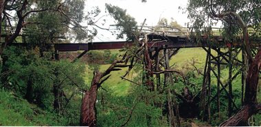
Photograph, Warrandyte Bridge, c.1860, 1860c
Old timber trestle bridge before it was washed away. Note sign in background for P. Bird Timber Merchant Box Hill. Photo has been damp at some stage and image has stuck to glass causing some damage to image in a number of areas.Black and white photograph mounted in thin black framebox hill, p. bird timber merchant, warrandyte bridge, yarra river -
 Hume City Civic Collection
Photograph, Early 1990's
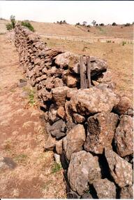
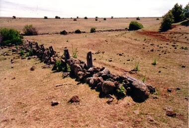
This is a photograph of one of the many stone ruins which can be seen in the Sunbury area and surrounding districts. These ruins are found in varying degrees of structural damage caused by erosion, vegetation growth and vandalism. The post and stone fence at Emu Creek at Bulla is more intact in this photograph.A coloured photograph of a post and stone fence surrounded by sun drenched paddocks.stone structures, post and stone fences, emu creek, george evans collection -
 Orbost & District Historical Society
black and white photograph, February 1971
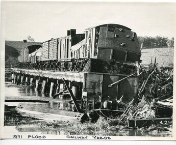
The 1971 flood was the the worst flood on record. At Jarrahmond it was at least 11 metres and up to one and a half kilometres wide on the flats causing enormous damage to the flood plain. Records say that "The brown floodwater stain in Bass Strait could be seen from passing airliners." Considerable damage was done to railway infrastructure, roads and farms. More information from the APRIL, 2008 newsletter by John Phillips. (see orbosthistory.com.au) The railway line was destroyed and was not expected to be opened for a fortnight. Orbost was cut off by 50 square miles of Snowy River floodwater. This train was being shunted across the viaduct when waters smashed through washing away several trucks sending the crew running for their lives.This is pictorial evidence of a significant local event. It is connected to the history of the railway in East Gippsland.A large black / white photograph of flooded railway yards with a train engine stranded on a small section of track surrounded by water and debris.on front - "1971 Flood, Railway Yards"floods-1971-orbost orbost-railway natural-disasters-orbost -
 Charlton Golden Grains Museum Inc
Photograph, Charlton Gentlemen's Club c. 1987, c.1987
The Charlton Gentleman's Club was established in 1900 by solicitor Ben Green. The original building had a narrow entrance off High St, between Egan & Spain's Grocery Shop and the Central Café. After fire damaged the buildings in the 1970s, the club was extended to its present size. The vacant block next door was formerly Clark's butcher's shop. Part of a series of streetscapes taken for the Charlton Shire in 1987. Charlton club was established in 1900 in a building with a narrow entrance off High Street between Egan and Spain's Grocery shop and the Central Cafe. After fire damaged the buildings in 1970's the Club was extended to its present size. The vacant block was formerly a butchers shop.Colour photograph of a single storey, glass fronted building with a white-framed front door. There is a large light pole and a white panel van and a white car are in front of the building. There is a blue awning over a yellow seat to the right of the building. Next to the seat is yellow metal fencing. On the far right of the photo is the side of an old brick building. charlton gentlemen's club, ben green, clark's butcher -
 Mission to Seafarers Victoria
Letter - Correspondence, 25/01/1952
Allan writes of the sinking of the SS Flying Enterprise. Having been damaged in a storm it was towed about 300 miles with only the captain Kurt Carlsen and the Mate from the salvage tug on board. The ship sank when hit by a second storm 40 miles off Falmouth.Quinn CollectionA pale blue self-folding letter (0893.a1) headed 37 Elsham Road, London W 14 and dated 25/01/52. Letter is typed using a very small font. It is addressed to Mrs K Hayes, 14 Fitzroy Street, St Kilda, Victoria, Australia and postmarked London W1. The return address is Allan Quinn, 37 Elsham Road, London W14. letters-from-abroad, allan quinn, alette andersen, london-uk, ss flying enterprise, captain (henrik) kurt carlsen -
 Hume City Civic Collection
Photograph, Early 1990's
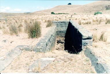
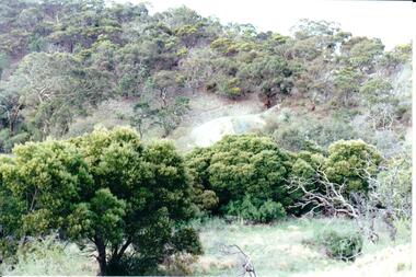
This is a photograph of one of the many stone ruins which can be seen in the Sunbury area and surrounding districts. These ruins are found in varying degrees of structural damage caused by erosion, vegetation growth and vandalism. The bluestone structure was a sheep dip on the 'Karoora Park' property near Jacksons Creek.A coloured photograph of the stone remains of a sheep dip constructed from basalt rock. The ground at the entrance slopes down into a narrow walled channel. The surrounding paddocks are covered with tussocks of grass and there are bare hills in the background. The grass is brown.stone structures, sheep dips, basalt rock, 'karoora park', george evans collection -
 Hume City Civic Collection
Photograph, Early 1990's
This is a photograph of one of the many stone ruins which can be seen in the Sunbury area and surrounding districts. These ruins are found in varying degrees of structural damage caused by erosion, vegetation growth and vandalism. The remains of the post and stone fence can be seen near Emu Creek at Bulla.A coloured photograph of the remains of a low post and stone fence in a sunburnt paddock. There are a few low growing bushes dotted across the paddocks.stone structures, dry stone walls, post and stone fences, george evans collection -
 Ballarat Heritage Services
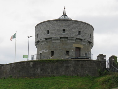
Digital Photograph, Tower, Drogheda, Ireland, 2016, 09/2016
The great mill mound is reported to be the burial ground of Amergin, and early Celtic poet. It was used as a fortified motte and bailey by the Normans during the 12th century. It later offered resistance to Cromwell in 1649. the present tower was built in 1808 but was damaged in 1922 during the Civil War in Ireland.drogheda, ireland -
 Linton and District Historical Society Inc
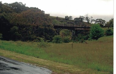
Photograph, Dilapidated bridge over Springdallah Creek, Happy Valley/Piggoreet, 2010
This bridge was built in the 1880s. By the 1980s it was in a dilapidated condition and was replaced. The old bridge was further damaged by storms and flooding in November 2010 and January 2011. (The newer bridge was completely washed away when the Springdallah Creek flooded in January 2011.) In 2025, little remains of the old bridge.Colour photograph of a trestle bridge spanning Springdallah Creek, Linton-Piggoreet Road.trestle bridges, old springdallah bridge -
 Linton and District Historical Society Inc
Photograph, Dilapidated bridge over Springdallah Creek, Happy Valley/Piggoreet, 2010
This bridge was built in the 1880s. By the 1980s it was in a dilapidated condition and was replaced. The old bridge was further damaged by storms and flooding in November 2010 and January 2011. (The newer bridge was completely washed away when the Springdallah Creek flooded in January 2011.) In 2025, little remains of the old bridge.Two colour photographs of a trestle bridge spanning Springdallah Creek, Linton-Piggoreet Road. The two photographs have been sticky-taped together to form one panoramic image.trestle bridges, old springdallah bridge -
 Charlton Golden Grains Museum Inc
Photograph, Cameron, Ian, 01/02/1973
Taken by the editor of The Charlton Tribune Ian Cameron. Of the 1973 flood at Gordon Park and Croquet Club. Highest flood since 1956, 25 feet 1 1/2 at the bridge, 4 inches of rain fell in the catchment. Road damage after the flood was estimated to be $74,800.Large sepia photograph unframed, creased in top RH corner, surface torn on left edge. Unmountedflood, gordon park, croquet club, charlton -
 Ballan Shire Historical Society
Map - Map. Kerrit Bareet, Department of Lands and Survey, Kerrit Bareet. County of Grant, 08/1944
A map of the Kerrit Bareet area within the County of Grant showing properties and names of owners in 1944.Significant to people researching land usage and ownership. Also those researching families in the area at that time.A map of Kerrit Bareet in the County of Grant. Black printing on buff coloured paper. Details roads, rivers, railways, property boundaries and names of property owners and towns and villages. The map is easily readable although there is some physical damage and that and the borders have been reinforced with sellotape. Shows a Scale in Chains and Price 2/.gordon, bungal, kerrit bareet, lal lal, moorarbool river, warrenheip, bungaree, wallace, moorarbool west -
Warrnambool and District Historical Society Inc.
Newspaper - Bound Volumes of The Junior Argus Newspaper, Richard Arthur Maddern Wellington, 1934 to 1937
Bound volumes of newspapers containing fiction and non fiction material..1 Copies of a newspaper bound with a grey and black mottled cover with black binding on the spine which has some damage. .2 As above but with a cream and black mottled cover. and the tape missing on the spine. .3 As above but with spine binding intact .4 as above All have a library stamp inside the front cover.fictionBound volumes of newspapers containing fiction and non fiction material.argus newspaper, orana, junior argus -
 Victoria Police Museum
Photograph (police car), Kodak
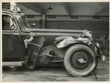
Close-up photograph of 4.3 litre 6 cylinder Alvis Wireless Patrol car registration number 174-614 at Russell Street garage with significant damage to the front right hand wheel arch, circa 1937. Over the windscreen is the illuminated "Police" sign and on the roof are metals tubes containing the wireless aerials.police vehicles; transport; motor police branch; alvis car; wireless patrol; russell street -
 Bendigo Historical Society Inc.
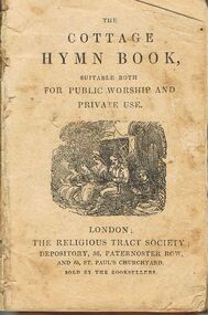
Book - LYDIA CHANCELLOR COLLECTION: ' THE COTTAGE HYMN BOOK'
A very small and damaged book titled '' The Cottage Hymn Book, suitable both for public worship and private use.'' London: The Religious Tract Society; Depository, 56 Patrernoster Row, and, 65 St. Paul's Churchyard, sold by the Booksellers. Printed by P. White & Son, Printers, Devonshire Square, London. Date unknownPrinted by P. White & Son, Printers, Devonshire Square, London. Date unknownreligions, christian, hymns, lydia chancellor collection, collection, religions, christianity, singing, worship, songs, hymns, church, music -
 Bendigo Historical Society Inc.
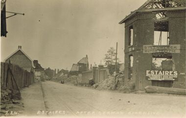
Postcard - ACC LOCK COLLECTION: ESTAIRES AFTER GERMAN OFFENSIVE, POST, 1914-1918
Postcard, WW1, B&W image of Estaires after a German offensive. Damaged/ruined buildings on sides of road. Two signs on building at right - 'Steenwerck Motor Traffic' and 'Estaires'. The latter has two arrows pointing in opposite directions to other towns. Copy Z 24 See also Copy 1401.73postcard, postcard, ww1, france, estaires, ruins -
 Bendigo Historical Society Inc.
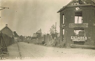
Postcard - ACC LOCK COLLECTION: ESTAIRES AFTER GERMAN OFFENSIVE, POSTCARD, 1914-1918
Postcard, WW1, B&W image of Estaires after a German offensive. Damaged/ruined buildings on sides of road. Two signs on building at right - 'Steenwerck Motor Traffic' and 'Estaires'. The latter has two arrows pointing in opposite directions to other towns. Copy Z 24 See also Copy 1401.108postcard -
 Bendigo Historical Society Inc.
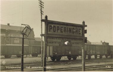
Postcard - ACC LOCK COLLECTION: POPERINGHE THE STATION YARD, POSTCARD, 1914-1918
Postcard, WW1, B&W image of the railway yard at Poperinghe. The sign 'Poperinghe' is in front of several railway wagons next to a damaged street lamp. The building in left background has a sign 'Houblons'. This word translates as 'hops'. Poperinghe is a major hop growing area near the Belgium border. Copy Y 37postcard, postcard, ww1, france, poperinghe, railway yard, houblons -
 Kilmore Historical Society
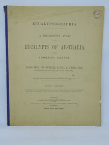
Book, Baron Ferdinand von Mueller et al, EUCALYPTOGRAPHIA. Third Decade, 1879
A descriptive atlas of the Eucalypts of Australia and the adjoining islandsLight card cover, creased top right front, tearing at bottom, with faded and worn blue cloth backstrip to spine. Backstrip torn at top and separated from body of book. Several pages missing at the front. Moisture stains on cover. Minor insect damage to some pages. Foxing throughout. Poor condition.non-fictionA descriptive atlas of the Eucalypts of Australia and the adjoining islandsbotany, eucalypts, australia -
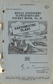 National Vietnam Veterans Museum (NVVM)
Booklet, British Army, Royal Engineers Supplementary Pocket ook No. 5C: Earthmoving Plant, 1951, 1951
A blusih coloured cardboard with black information on the front cover. At the top of the page written in pencil is the name Hallett. Top right hand corner rewds WO Code No. 8632. There are three punch holes and two metal staples down the left hand side. Parts of the cover are damaged down the left hand side.british armed forces - service manuals, royal engineers, pocket book, earthmoving plant -
Melbourne Tram Museum
Newspaper, The Herald, “And Four Were Hurt”, 13/02/1969 12:00:00 AM
“And Four Were Hurt” Photos and text from the Herald 13/2/69 showing damage to bus and tram. Tram crash Holden St, North Fitzroy Four people were treated at St Vincent's Hospital, tram had no passengers and was on the way to Preston Workshops, possibly tram 907, could be 807trams, tramways, accidents, collision, holden st, buses, preston workshops, tram 907? -
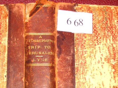 Stawell Historical Society Inc
Book, Augustus A. Lyne R.N, A Midshipman’s Trip to Jerusalem, 1871
This book at one time belonged to the Pleasant Creek Library and Mechanic Insititute, Quartz Reefs. The Adventures of a cavalcade of British Naval Officers in the Holy Land. Dedicated by permission to: Captain George Lethbridge R.N. and the Officers of H.M.S. TrafalgarBrown Spine and Cornors, front and back patterned paper cover, part missing, clear tape on spine top and bottom. Top Right Inside Cover J.W. Evans & Co. Binders 11A Flinders Way. Notice pasted on inside of front Cover. No. 1313. Pleasant Creek Library and Mechanics Institute Quartz Reef. Members will be held responsible for any damage done to books in their possession.stawell education -
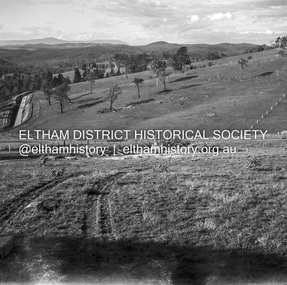
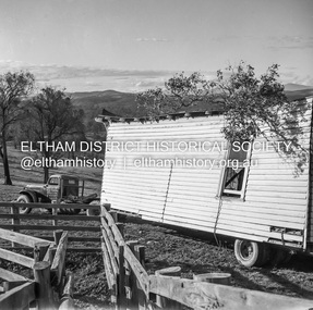
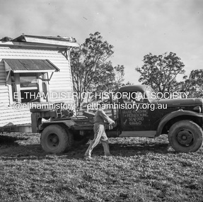 Eltham District Historical Society Inc
Negative - Photograph, J.A. McDonald, Removal of the remains of the Abraham house at Kangaroo Ground, c. May 1962
Martin Bros House Removing of Seaford was contracted to remove the remains of the storm damaged Abraham house from the property circa May 1962. The Abraham family owned land near the Aqueduct and east of Nicholas Lane at Kangaroo Ground (based on photos, at or near 40 Nicholas Lane).Record of various Shire of Eltham infrastructure works undertaken during the period of 1952-1962 involving bridge and road reconstruction projects, sometimes with Eltham Shire Council Project Reference numbers quoted. It was during this period that a number of significant improvements were made to roads and new bridges constructed within the shire that remain in place as of present day (2022). In many situations, the photos provide a tangible visible record of infrastructure that existed throughout the early days of the Shire. The album was put together by or under the direction of the Shire Engineer, J.A. McDonald.1962-05, abraham house, kangaroo ground, martin bros house removing seaford, nicholas lane, property damage -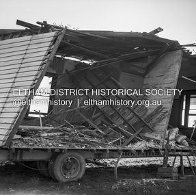
 Mission to Seafarers Victoria
Photograph - Photograph, Black and white, Allan Charles Quinn, 5 June 1949
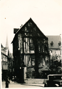
This photograph is one of a series taken by Allan while travelling through France in mid-1946. It was taken in the medieval city of Rouen, a city heavily damaged by the Allied bombings during the Battle of Normandy in May 1944 and shows a cob house, typical of the period. There are several letters relating to this journey.This is a photograph from the Allan Charles Quinn collection which is a collection of letters and photograph depicting aspects of life at sea for a young man in the era immediately following World War II.Black and white photograph of a historical building and street scape in Rouen.On reverse: ROUEN 5-6-49 handwritten in blue ink. Below this is a mark "ItI"in pencil, written sideways.allan-quinn, photograph, rouen, france, ww2, battle of normandy, normandy, cob house, middle ages, medieval -
 Mission to Seafarers Victoria
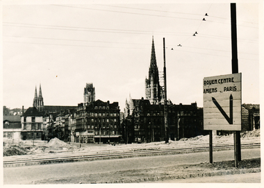
Photograph - Photograph, Black and white, Allan Charles Quinn, Rouen Centre, Amiens, Paris, 6 June 1949
This photograph is one of a series taken by Allan while travelling through France in mid-1949. It shows the Saint-Ouen Abbey Church from Rue d'Amiens- Rouen. Rouen, a medieval city was heavily damaged by Allied bombings during the Battle of Normandy. There are several letters relating to this journey.This is a photograph from the Allan Charles Quinn collection which is a collection of letters and photograph depicting aspects of life at sea for a young man in the era immediately following World War II.A black and white photograph taken on the 5th of June, 1949, of Saint-Ouen church built in the 14th century in Rouen, France. The sign to the right of the foreground reads: ROUEN CENTRE / AMIENS PARIS and probably indicates the photograph was taken from Rue d'Amiens (Amiens Street). The photograph shows the level of demolition of the city during World War II.On reverse: PARIS 6-6-49 handwritten in blue ink. below this is a pencil mark, similar to "ItI".allan-quinn, photograph, rouen, france, normandy, ww2, battle of normandy, 1939-1945, saint ouen abbey, amiens, paris -
 Hume City Civic Collection
Photograph, Early 1990's
This is a photograph of one of the many stone ruins which can be seen in the Sunbury area and surrounding districts. These ruins are found in varying degrees of structural damage caused by erosion, vegetation growth and vandalism. The adit and mullock heap is from one of the mines on Redstone Hill. It was known as Batey's Mine.A coloured photograph of the remains of a mullock heap and adit from a mine. The entrance is surrounded by low growing trees and grass.stone structures, batey's mine, gold mining, redstone hill, george evans collection