Showing 2530 items
matching building and planning
-
 Bendigo Military Museum
Photograph - Detachment - Army Survey Regiment, Bonegilla, Victoria, c1973
This is a set of three photographs of personnel from the Detachment - Army Survey Regiment taken in front of its main map production building at Bonegilla, Victoria in c1973. This cartographic map production sub-unit of the Army Survey Regiment operated in buildings owned by the School of Military Survey from 17th of June 1970 to the 30th of September 1985. A total of 800 topographic maps ranging in scale from 1:25,000 to 1: 250,000 scale were completed. A major focus of production in the 1970s was the cartographic completion of the Papua-New Guinea 1:100,000 map series and the Flexiflow quality control system was developed as a tool to coordinate production. The Flexiflow system comprised a series of job plans and charts linked to a task allocation to resource magnetic planning board. Using critical path analysis and task prioritisation, complex job planning was efficiently scheduled, and re-prioritisations readily made. Reproduction requirements were effectively coordinated by way of weekly courier to the Army Survey Regiment at Bendigo. Supervisors and technicians fully embraced the system as they could understand their role, others around them and the positive production achievements. WO1 Bill Boyd (who does not appear in this photograph) was the technical warrant officer for 11 years at the Detachment was awarded the OAM, the Order of Australia Medal for leading the development and the implementation of the Flexiflow system. By mid-1982, production of maps at these scales was undertaken digitally on Bendigo’s AUTOMAP 2 system and the Detachment reverted to production of small-scale large format RAAF aeronautical charts. Detachment personnel managed to produce 18 charts in the following two years, which was an impressive achievement for the staff, given major differences in format, specification and scales. Development of digital production of aeronautical charts in 1984-85 led to gradual reduction in production output and contracting out production was instigated to meet the shortfall and as a consequence the Detachment closed in September 1985. See pages 177 to 180 of Valerie Lovejoy’s book 'Mapmakers of Fortuna – A history of the Army Survey Regiment’ ISBN: 0-646-42120-4. for more information on the history of the Detachment at Bonegilla.This is a set of three photographs of the Detachment - Army Survey Regiment taken in front of the main map production building at Bonegilla, Victoria in c1973. The photographs were printed on photographic paper and are part of the Army Survey Regiment’s Collection. The photographic proofs were scanned at 600 dpi. .1) to .3) - Photo, black & white c1973. Back Row L to R: Peter Simpson, Chris Edwards, unidentified (x2), Colin Harden, Rowan Gillies, Bob Rowley OAM, Steve Hansen, Stu Thaxter. Centre Row L to R: Kevin Boehm, Dennis McCarthy, Peter Cross, unidentified, Brian Ryan, unidentified, Ian Marner, unidentified, Phil Smalley. Front Row L to R: Geoff Haynes, Bruce Wetzig, Dave Thompson, unidentified, OC Bob Roche, Ike Lever, John McCulloch, Dick Barwald, unidentified. There are no personnel annotated.royal australian survey corps, rasvy, army survey regiment, detachment - army survey regiment, army svy regt, asr -
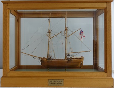 Flagstaff Hill Maritime Museum and Village
Craft - Ship Model, Port Jackson Schooner
This ship model is of a Colonial Port Jackson schooner, originally designed by the British Admiralty in 1803 as a response to the request of New South Wales' Governor Arthur Phillip. The drafts for the original plans are in Greenwich, UK, in the National Maritime Museum. The model is a Ledition edition, number 2 of 5, modelled by Bill Leonard. The model is rigged and decked in the manner of David McGregor. The flag on model of Port Jackson schooner is that of the British White Ensign which was used as the flag design of the Royal Australian Navy from 1911 - 1967. In 1785 the First Fleet arrived in the new British colony of Port Jackson (now Sydney Harbour) in New South Wales and Arthur Phillip was appointed as the first Governor. The following year Governor Phillip asked the English Royal Navy to provide drafts and materials for two ships for use in the Port Jackson colony for exploring and surveying rivers. The vessels needed a shallow draught and to be made from local cedar timber. He asked for the frames of the schooners to be provided along with shipwrights to assemble them. Many years later, in 1803, Governor Phillip’s request was fulfilled but he had already resigned from his post. The drafts titled ‘Schooner for Port Jackson’ were despatched by the Royal Navy from England to Australia. The original draft is still in the National Maritime Museum in Greenwich, UK. Meanwhile, the NSW Government had already built various other ships before 1803. In 1797 His Majesty’s Dockyard was opened at Port Jackson for building larger vessels. The Royal Navy’s 1803 design of a ‘Schooner for Port Jackson’ has been recognised on the obverse of Australia’s twenty dollar banknote since 1994. A sketch of the schooner is beside the portrait of Mrs Mary Reibey, who arrived as a convict and rose to become a respected and successful owner of a cargo shipping business. Her fleet included the Mercury, a schooner similar to the 1803 design for the Port Jackson schooner. Although the 1803 plans for a ‘Schooner for Port Jackson’ are commonly believed to be used for the first ship built in Australia, no records have been found of any ships being built according to these plans. However, it can be claimed that the plans were the ‘first Royal Navy plans made for a ship for use at Port Jackson, and to be built at Port Jackson, in Australia’. William (Bill) Leonard passed away on March 1st 1995.This ship model is significant for its representation of an early Australian colonial schooner. The 1803 Royal Navy’s plans for the colonial ‘Schooner for Port Jackson, were for the first ship specifically designed by the Royal Navy to be built and used in Port Jackson, for use in exploration and surveying of Australian ports and rivers. The plans are associated with Australia’s colonial settlement in the late 1700s. This ship model is significant for its association with the emblems of Australia’s history on the twenty dollar banknote. The colonial Port Jackson schooner is considered significant to Australian history, and represented on the 1994 twenty dollar banknote and its new version being rolled out in October 2019.Ship model of a colonial Port Jackson Schooner. Two-masted sailing ship displaying the flag named The British White Ensign. Mode of light coloured stained timberl is mounted on brass legs inside a glass case with timber frame and base. Metal engraved plaque states that the model is as designed by The Admiralty in 1803. Model is a number 2 of 5 in a limited edition, made by Bill Leonard.Engraved on metal plaque "PORT JACKSON SCHOONER / As Designed By The Admiralty. 1803"flagstaff hill, warrnambool, shipwrecked-coast, flagstaff-hill, flagstaff-hill-maritime-museum, maritime-museum, shipwreck-coast, flagstaff-hill-maritime-village, ship model port jackson schooner, sailing ship, limited edition model, model maker bill leonard, david mcgregor design, maritime trade, maritime vessel, colonial port jackson schooner, pacific island trade in early 1800s, sydney cove, governor arthur phillip, governor philip gidley king, a schooner for port jackson, national maritime museum greenwich, australian $20 banknote -
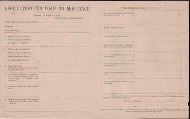 Bendigo Historical Society Inc.
Document - KELLY AND ALLSOP COLLECTION: APPLICATION FOR LOAN ON MORTGAGE
Application for Loan on Mortgage. Messrs Allsop & Co., View Point, Sandhurst. Application has space for name, occupation, amount of Loan, number of years, interest rate, Where, number of Allotment, Section, parish or County, Area, Leasehold or Freehold. Applicants opinion as to value of Land alone. Number of Acres under Cultivation. How Land is watered. State Shire Valuation, Description of Buildings and materials used, Fences, Improvements. Application for Loan on Mortgage. Messrs Allsop & Co., View Point, Sandhurst. Application has space for name, occupation, amount of Loan, number of years, interest rate. Where, number of Allotment, Section, parish or County, Area, Leasehold or Freehold. Applicants opinion as to value of Land alone. Number of Acres under Cultivation. How Land is watered, State Shire Valuation, Description of Buildings and materials used, Fences, Improvements. Is applicant in occupation of Property, if not who is, and at what Rental. Are Buildings Insured, if so, what amount. Is the Property encumbered, is so, to what amount. Present marketable value of the whole, and names and addresses of two references. Authorization to deduct from the advance the costs of the Mortgage and Charges on obtaining the Loan. Note at the end - A Government plan, or sketch showing the position of the land and written valuation from an acknowledged Valuer. On the back is space for a Valuator's Report and a note to the Valuators, also a Proposal for Loan on Mortgage with details of the loan. Date on the form is 188-.business, stockbroker, kelly & allsop, kelly and allsop collection - application for loan on mortgage, allsop & co. -
 Kew Historical Society Inc
Plan - Subdivision Plan, Violet Farm Estate, 1927
Pru Sanderson, in her groundbreaking ‘City of Kew Urban Conservation Study : Volume 2 - Development History’ (1988), summarised the periods of urban development and subdivisions of land in Kew. The periods that she identified included 1845-1880, 1880-1893, 1893-1921, 1921-1933, 1933-1943, and Post-War Development. These periods were selected as they represented periods of rapid growth or decline in urban development. An obvious starting point for Sanderson’s groupings involved population growth and the associated economic cycles. These cycles also highlighted urban expansion onto land that was predominantly rural, although in other cases it represented the decline and breakup of large estates. A number of the plans in the Kew Historical Society’s collection can also be found in other collections, such as those of the State Library of Victoria and the Boroondara Library Service. A number are however unique to the collection.The Kew Historical Society collection includes almost 100 subdivision plans pertaining to suburbs of the City of Melbourne. Most of these are of Kew, Kew East or Studley Park, although a smaller number are plans of Camberwell, Deepdene, Balwyn and Hawthorn. It is believed that the majority of the plans were gifted to the Society by persons connected with the real estate firm - J. R. Mathers and McMillan, 136 Cotham Road, Kew. The Plans in the collection are rarely in pristine form, being working plans on which the agent would write notes and record lots sold and the prices of these.The subdivision plans are historically significant examples of the growth of urban Melbourne from the beginning of the 20th Century up until the 1980s. A number of the plans are double-sided and often include a photograph on the reverse. A subdivision plan for nineteen ‘bonny, airy building blocks’ on either side of Violet Grove, Kew East. Violet Grove runs between High Street and Harp Road. Like many other subdivisions in Kew and East Kew, older houses (Lots 1 and 13) were often included in the subdivision. Such houses were in some instances the original properties that were subdivided, or in the case of the Violet Grove subdivision, new houses such as the weatherboard villa on lot 13. This villa is advertised as having a tiled roof, 5 rooms, panelled hall, double doors (Rooms 14 x 12 ft. 6 in. (2) 14 x 12, 12 x 11, 13 x 11). A bricked front verandah, a tiled stove recess and existing sewerage connection added to its saleable potential. Water, electric light and power, and gas were all offered as part of the deal. Violet Grove now has about 35 houses, which indicates that the 19 lots of the subdivision were to be further subdivided by purchasers. [A similar plan is in the Batten & Percy Collection of the State Library of Victoria.]subdivision plans - east kew, violet farm estate, violet grove -- kew (vic.), boorool road -- kew (vic.), harp road -- kew east (vic.) -
 Glen Eira Historical Society
Photograph - NETTALIE
Various documents about and photographs of Nettalie or Netley House or The Nest on Balaclava Road Caulfield now part of Melbourne Grammar School: 1/The first is an article undated and unattributed accessed from Beresford.org on 14/07/2006 detailing with bibliography the history of Netley House including the owners especially the Shaw family. 2/There are several separately colour-printed photographs of the front facade of Nettalie most undated and unattributed, and one family portrait of the Shaw family circa 1863. All were also accessed from Beresford.org on 14/07/2006. 3/One black and white photograph is inscribed '73 Balaclava Rd Caulfield 3/9/72 Neg 16A'. 4/Two copies of a plan of Nettalie next to The Curragh and Harleston, also in the article and likely accessed from same source on same date. 5/A copy of Dr Cameron’s letter to Herbert Shaw dated 24/05/1949. 6/One copy of a letter from Herbert Shaw to Dr William Cameron dated 25/05/1949. 7/A plan of Melbourne Grammar School with each building dated to when it was built including Netley House in 1863.shaw herbert, shaw alfred henry, shaw arthur, shaw amelia, shaw lavinia, forsyth william, blundell mary, fosbery john, bakewell john, hailes george b, blundell miss, stephen george sir, billings richard, ware martha, desailly alfred, cameron william dr, cameron j mrs, nettalie, the nest, netley house, house names, caulfield north, balaclava road, grimwade house, orrong road, harleston, caulfield road district, st kilda east, the curragh, shelford, helenslea, sylliot hall, labassa, o’loughlin street, ormond, hotham street, melbourne grammar school, caulfield conservation study, mansions, teachers, schools, independent schools, hardware stores, business people, lawyers, businesses, brick houses, outbuildings, architectural styles, classrooms, bunya bunya pine trees, trees, orchards, land subdivisions, land sales, doctors -
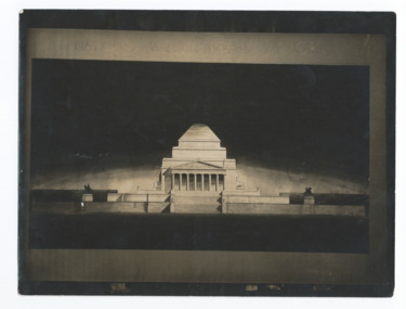 Melbourne Legacy
Photograph, National War Memorial of Victoria, 1928
A photo of a model produced by Hudson and Wardrop, Architects, who had won the contest for the design of the Shrine. This photo shows their model of the Shrine as seen from the North. It is with their Brochure on the First Premiated Design (see 01208) which goes into detail of the plans for Rock of Remembrance, the eye of light, the porticos, the tympanums, the inner Shine, and materials it will use, etc. It says: 'The theme is Remembrance, and the doing is indicative of Remembrance. It is Australian in feeling, in that is stands fo rate highest of Australian ideals - ideals we fought for - Patriotism, Sacrifice, Justice and Freedom.' Messrs Hudson and Wardrop were also returned servicemen. This photo could have been used to inform the public of the plans whilst fundraising for the building project. In 1928 the Governor asked for the public to contribute approx £100,000 towards the project, while the State Government had already guaranteed £80,000. Item was in an envelope with other photos and programmes from different items relating to the Shrine of Remembrance - including discussions on its location and design. Labelled 'Shrine of Remembrance S1 - S14' it was part of an old archive numbering system, that showed there has been efforts in the past to collect, order and save items of Legacy's history. (01181 - 01190, 01206 - 01211).A record of the planning for the Shrine of Remembrance with details from the architects who had won the design contest. There was an effort to record historical events for the "Archive Committee" which collected this and other documents relating to the Shrine together in a file (see items 01181 - 01190, 01206 - 01211).Black and white photo of the architects model of the Shrine of Remembrance.memorial, shrine of remembrance -
 Eltham District Historical Society Inc
Photograph, Fay Bridge, Local humour added to Art Gallery sign, 559 Main Road, Eltham, 5 December 2004
Photo taken immediately after the Wiregrass gallery closed at the end of November. The property was purchased in October 2004 for $565,000 by a local investment company, Sentinel Equities run by local residents Jethro and Suzanne Still. Plans to redevelop the property into offices and a gallery designed by Robert Marshall and supported by a number of local artists met with opposition from Eltham Gateway Action Group in 2007 over the proposed new building size and insufficient parking provision given the proposed reliance on the VicRoads reserve on Main Road for parking. The development proposal was finally approved by VCAT in January 2008 subject to VicRoads approving the use of the road reserve for parking. That did not happen and the property remains undeveloped 15 years later (August 2023).fay bridge collection, 559 main road eltham, 2004-12-05, eltham, eltham gallery, graffiti, main road, wiregrass gallery -
 Federation University Historical Collection
Photographs - 5 black and white, Ballarat Junior Technical School Social Function - 1975, 1975
On 28 March 1981 the Ballarat College of Advanced Education 1870 Founders hall was opened. The hall was erected from the proceeds of the Centenary Appeal, held in 1975. It cost approximately $800,000. The hall commemorates the initiative of the founders of the original Ballarat School of Mines and its "descendants", including Ballarat College of Advanced Education, as well as formal technical education in Australia. The hall plans were to erect a building to accommodate 670 persons in a theatre type seating arrangement and to be used for multi-purpose use by community groups as well as by the College. Construction of the hall commenced in 1978. It was opened approximately 110 years after the Ballarat School of Mines (26 October 1870) and 10 years after the opening of the Mt Helen Campus (31 October 1870)..1) Morgan B. John on left with Bill North right. .2) L to R:- Betty Barrell; W.J.North; John Vernon; A.C.Burrow; Mrs North; Dulcie Burrow; Mrs Webb; K.C.Webb; Geoffrey Barrell .3) L to R:- unidentified; E.J. Tippett; Bert Stohr .4) L to R:- Mrs Handford-Stevens; Mrs Nicholson; J Handford-Stevens; Sir A Nicholson, Mayor of Ballarat .5) L to R:- Bill North; unidentified; S Martin-Brown; unidentifiedPhotographer's stamp on back of each photograph. .1) In pencil: "at Centenary Appeal conclusion reception 1975"; "M.B.John, President of (BIAE crossed out) SMB Council; W.J.C.(Bill) North, appeal committee chairman"; 10 - 3. .2) 10 - 4 .3) 10 - 2 .4) 10 - 1 .5) 10 - 5 a.w. nicholson, e.j. tippett, m.b. john, morgan b. john, ballarat junior technical school, ballarat school of mines, ballarat college of advanced education, 1870 founders hall, centenary appeal, 1978, 1981 -
 Federation University Historical Collection
Poster, Michael McBain, Cliff Beauglehole Plant Collection
The Beauglehole Collection is held in the FedUni Science Herbarium (Mt Helen Y Building). Cliff Beauglehole (1920-2002) was an orchardist at Portland, Victoria. Over his lifetime he collected over 90,000 plant specimens as part of a comprehensice study of Victoria's plans, and wrote thirteen books under the title "The Distribution and Conservation of Vascular Plants in Victoria. Originally held by the Ballarat Field Naturalists Club, this set of herbarium specimens are from Cliff Beauglehole's collections in the Ballarat area. The club decided to hand over the plant collection to the University of Ballarat (now Federation University). They were freeze-dried to kill unwanted insects and are now house in a climate conrolled room, and available to students, staff and others for scientific study. Listing of specimens held in the Federation University Cliff Beauglehole Collection, and interpretation poster. herbarium, botany, botanical, text panel, cliff beauglehole, beauglehole collection, ballarat field naturalists club, plant specimens -
 Vision Australia
Administrative record - Text, Seventeenth Annual Report of the Association for the Advancement of the Blind 1912, 1912
Annual report of the Association for the Advancement of the Blind outlined activities and events over the year, including membership of 333, with the support of Mrs W.H. Edgar and the Lady Mayoress of Melbourne, 'Woodburn' was purchased and there were sufficient funds to reconstruct a wing to the present brick building, and plans are being drawn up under the supervision of Mr Paterson for some necessary extensions, the North Melbourne and Essendon Electric Tramway and Northcote Cable Tramway were added to the Railway Pass concession scheme, a successful concert tour was made of the Goulburn Valley from Alexandra down to the Murray, the loss of Mr Bacon - who was the first Blind Collector appointed by the Association - and Mrs May Harrison, VABW secretary who tirelessly promoted the welfare of the blind.1 volume of printed material with some illustrationsassociation for the advancement of the blind, annual reports -
 Eltham District Historical Society Inc
Audio - Audio Recording, Jim Connor - From Eltham to Nillumbik Shires and subsequent development proposals of the former Eltham Shire Office site - a personal perspective, 2 Jun. 2024
Guest speaker at Eltham Community Action Group (ECAG) Annual General Meeting The Shire of Eltham was established in 1871 and ceased to exist, due to a municipal restructure, when all councillors were sacked on 15 December 1994. Jim Connor, a past Councillor of the former Shire of Eltham and current President of the Eltham District Historical Society gave a very interesting presentation about the machinations of how and why Eltham became Nillumbik. He also displayed and discussed images of the various plans that have been suggested for the former Shire Office Site since the building was demolished by the decision of the commissioners in July 1996, the commissioners having replaced the elected council when the Kennett government amalgamated all Victorian councils.1:08:28 duration Digital MP3 file; 23.5MBaudio recording, meeting, eltham, guest speaker, commissioners, community engagement, community protest, council amalgamation, demolition, eltham gateway action group, eltham shire offices, jim connor, planning application, shire of eltham, shire of nillumbik, agm, eltham community action group (ecag), eltham district historical society -
 Eltham District Historical Society Inc
Film - Video (VHS), Phil Burke et al, Shire of Eltham Grants Commsission Submission (Series 69, Item 7), 1993
Shire of Eltham Archives: Series 69, Item 7 Opens with aerial views of the Shire, 85% of the shire covered by the Green wedge principal. Discusses the obligations required of the Shire to maintain the Green Wedge. The Shire covers over 27,000 hectares with a population in excess of 45,000 residents, more than 70% living in the southern 10% of the Shire in suburbs of Eltham, Montmorency, Lower Plenty and Research. 85% of the Shire in the more sparsely populated northern area which is covered by the Green Wedge. Council is committed to providing a parity of services to all residents such as garbage collection and maintenance of roads. Views of rubbish collection trucks in Montmorency. It is emphasised that the cost of these services in highly populated areas is relatively low whereas in the sparsely populated Green Wedge areas, considerable. There are hundreds of kilometres of roads throughout the Shire, many unmade and maintenance is high to check overhanging trees and erosion especially on the steep hills is expensive and disproportionate to servicing the population in the dense urban areas. Shows views of hilly gravel roads and graders at work maintaining them. Shows scenes of assessing planning applications in these rural areas which takes significantly more time as well as other services provided such as Meals on Wheels, building permits, Ranger services. Provision of recreational facilities in hilly areas requires the acquisition of expensive river flats (views of cricket ground surrounded by hills) and where not possible, costly earthmoving required. Also, views highlighting extensive tracks of natural habitat home to significant bird, animal and plant life. Shire emphasises its commitment highlighted by the Eltham Copper Butterfly which the Shire maintains small pockets of bushland to ensure its survival at significant expense (views of Pauline Toner Copper Butterfly Reserve.) Short interview with Pat Vaughan, Environmental Officer for the Shire discussing the Eltham Copper Butterfly who also mentions many other species in the Shire of high significance from bats to mammals to plants as well as the importance of the Green Wedge to Melbourne – the lungs of Melbourne - and ensuring the protection of very important habitat which requires a great deal of planning and management to look after. Views of Wingrove Park to emphasise this maintenance by machinery in some areas is too damaging and introduced species, etc must be removed by hand. Balancing the services and facilities expected by the community with the needs of the environment requires careful planning demands requires careful planning and the principals of the Green Wedge require constant attention in the face of growing need for housing. Director of Planning & Environment, Richard Allen advises there are approximately 1,300 planning permits and development applications each year ranging from simple subdivision, boundary realignments to further complicated non-urban developments for agricultural pursuits and the level of expertise required from architectural and engineering to land degradation, flora and fauna. Video finishes with aerial views and parklands, streetscapes and rural areas. VHS Video cassette Converted to MP4 file format 00:07:39; 89MBshire of eltham, video recording, shire of eltham archives, eltham shire council, eltham, building permits, cricket ground, development applications, eltham copper butterfly, garbage collection, graders, green wedge, lower plenty, meals on wheels, montmorency, pat vaughan, pauline toner reserve, planning applications, planning permits, ranger services, recreational facilities, research, richard allen, roads, rural areas, wingrove park, victoria grants commission -
 Eltham District Historical Society Inc
Negative - Photograph, Eltham War Memorial Obelisk 1914-1918, cnr. Main Road and Bridge Street, c.1925
Located on what was referred to as Obelisk Corner, improvements have been been made since the unveiling in August 1919 with the provision of a stone retaining wall topped with a chain link and granite stone boundary, most likely in conjunction with improvements to the intersection into Main Road. Along with the use of the name Obelisk Corner, the Bridge Street bridge was also known as Obelisk Bridge. The Eltham Obelisk was originally located at the corner of Bridge and Main Roads in 1919. In 1943 (WW2) the local community commenced plans to establish the Eltham War Memorial, a living memorial to benefit the children as opposed to a one in stone as per the obelisk. The Eltham War Memorial Trust was established in 1945. In 1947 the Trust intended for the Obelisk to be relocated from Bridge Street and Main Road to the Garden of Remembrance which was planned as part of the Baby Health Centre which was to be the first of three buildings of the Eltham War Memorial to be built in 1951. In 1951 the Eltham RSL was invited to be represented on the Eltham War Memorial Trust. Around this time, with pending roadworks, the obelisk was relocated to the front garden of the Eltham RSL sub branch on Main Road for safe keeping. In 2007, a suggestion was proposed by Harry Gilham (President, EDHS) to John Cohen (ERSL) to claim a special site along with the historic Shillinglaw trees on the now vacant former Eltham Shire Office site adjacent to the Eltham War Memorial precinct for relocation of the obelisk. In 2010 following the financial collapse and sale of the Eltham RSL Sub-Branch property and amalgamation with the Montmorency Eltham RSL sub-branch, the location of the obelisk was again in immediate jepoardy and in conjunction with Nillumbik Shire Council, the obelisk was relocated in front of the Eltham War Memorial buildings in preparation for the Dawn Service on Anzac Day 2012.This photo forms part of a collection of photographs gathered by the Shire of Eltham for their centenary project book,"Pioneers and Painters: 100 years of the Shire of Eltham" by Alan Marshall (1971). The collection of over 500 images is held in partnership between Eltham District Historical Society and Yarra Plenty Regional Library (Eltham Library) and is now formally known as the 'The Shire of Eltham Pioneers Photograph Collection.' It is significant in being the first community sourced collection representing the places and people of the Shire's first one hundred years.Digital image 4 x 5 inch B&W Negsepp, shire of eltham pioneers photograph collection, eltham, main road, eltham war memorial, bridge street, obelisk, obelisk corner -
 Eltham District Historical Society Inc
Photograph, Eltham War Memorial 1914-1918. Cnr. Main Road and Bridge Street, 3 August 1919
Dated 1919, the Eltham Obelisk is decorated with wreaths, most likely for what was originally known as Armistice Day though now known as Remembrance Day, 11 November. The location of the Obelisk at the corner of Bridge Street and Main Road became known as Obelisk Corner and the Bridge Street bridge was also referred to as Obelisk Bridge. The Eltham Obelisk was originally located at the corner of Bridge and Main Roads in 1919. In 1943 (WW2) the local community commenced plans to establish the Eltham War Memorial, a living memorial to benefit the children as opposed to a one in stone as per the obelisk. The Eltham War Memorial Trust was established in 1945. In 1947 the Trust intended for the Obelisk to be relocated from Bridge Street and Main Road to the Garden of Remembrance which was planned as part of the Baby Health Centre which was to be the first of three buildings of the Eltham War Memorial to be built in 1951. In 1951 the Eltham RSL was invited to be represented on the Eltham War Memorial Trust. Around this time, with pending roadworks, the obelisk was relocated to the front garden of the Eltham RSL sub branch on Main Road for safe keeping. In 2007, a suggestion was proposed by Harry Gilham (President, EDHS) to John Cohen (ERSL) to claim a special site along with the historic Shillinglaw trees on the now vacant former Eltham Shire Office site adjacent to the Eltham War Memorial precinct for relocation of the obelisk. In 2010 following the financial collapse and sale of the Eltham RSL Sub-Branch property and amalgamation with the Montmorency Eltham RSL sub-branch, the location of the obelisk was again in immediate jepoardy and in conjunction with Nillumbik Shire Council, the obelisk was relocated in front of the Eltham War Memorial buildings in preparation for the Dawn Service on Anzac Day 2012.This photo forms part of a collection of photographs gathered by the Shire of Eltham for their centenary project book,"Pioneers and Painters: 100 years of the Shire of Eltham" by Alan Marshall (1971). The collection of over 500 images is held in partnership between Eltham District Historical Society and Yarra Plenty Regional Library (Eltham Library) and is now formally known as 'The Shire of Eltham Pioneers Photograph Collection.' It is significant in being the first community sourced collection representing the places and people of the Shire's first one hundred years.Digital image 4 x 5 inch B&W Negsepp, shire of eltham pioneers photograph collection, eltham, main road, bridge street, eltham war memorial, obelisk, obelisk corner, wreath -
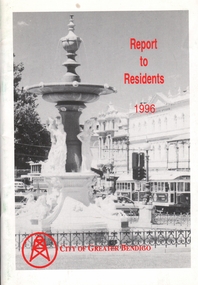 Bendigo Historical Society Inc.
Book - BOOKLET: REPORT TO RESIDENTS CITY OF GREATER BENDIGO, 1996
Front cover is a photo of Alexandra Fountain. 52 paged booklet - ''Report to Residents - City of Greater Bendigo, 1995. Table of Contents; The Mayor; Chief Executive Officer; Council meetings; Office location and hours; ''One Telephone Number''; Locations of functions and business; Units; Organisation Structure; Advisory Committee; Municipal Boundaries; Customer services; Economic development; Bendigo Tourism; Bendigo Trust; Events Bendigo; Capital works 1996/97; Bendigo Regional Arts Centre; Local laws; Aged and disability services; Children and family services; Environmental health; Recreation and leisure; Parks and gardens; Planning and building; Waste management in Bendigo; Library services; Rates; Budget for 1996/97; The budget at a glance; Index.bendigo, council, report -
 Glen Eira Historical Society
Album - Album page, Nithsdale now Five Way Hill, Kambrook Road, Circa 1972
This photograph is part of the Caulfield Historical Album 1972. This album was created in approximately 1972 as part of a project by the Caulfield Historical Society to assist in identifying buildings worthy of preservation. The album is related to a Survey the Caulfield Historical Society developed in collaboration with the National Trust of Australia (Victoria) and Caulfield City Council to identify historic buildings within the City of Caulfield that warranted the protection of a National Trust Classification. Principal photographer thought to be Trevor Hart, member of Caulfield Historical Society. Most photographs were taken between 1966-1972 with a small number of photographs being older and from unknown sources. All photographs are black and white except where stated, with 386 photographs over 198 pages. Glen Eira Heritage Management Plan (1996) by Andrew Ward and Associates - Vol 3 "Nithsdale", built for J.S. Crouchin 1858 and extended in 1885 with a tower and associated rooms, survives as testimony to the nineteenth century occupation of the vicinity of the Kambrook/Glen Eira Road intersection. Caulfield's Building Heritage by Dr Geulah Solomon, Vol 1 p49 records it as a small Victorian mansion home on bluestone foundations of Italianate style with a tower. Built for J S Chambers circa 1860, it was built in stages and then the land subdivided in the 1920s. Other owners include Adolph F Brockhoff (of Brockhoff Biscuits company). Names used besides Nithsdale have been Bundoora and Five Way Hill. Page 102 of Photograph Album with four photographs (three landscape and one portrait) of Nithsdale, now known as Five Way Hill. Three views of the tower and one of the house.Handwritten: "Nithsdale" now "Five Way Hill" Kambrook road [top right] / CNR KAMBROOK AND GLENEIRA ROADS [under bottom right photo] / 102 [bottom right]trevor hart, north caulfield, victorian, mid victorian, late victorian, tower, j.s. crouchin, 1850's, 1880's, italianate, rendered, five way hill, nithsdale, slate roof, plaster arches, ornamental columns, triangular pediment, ornamental parapet, cast iron balconies, kambrook road, glen eira road, t crouch, j s crouchin, mansions, j s chambers, bluestone foundations, land subdivision, adolph f brockhoff, bundoora, house names -
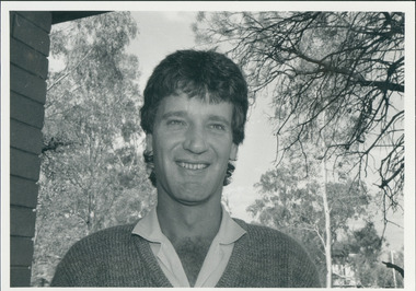 Uniting Church Archives - Synod of Victoria
Photograph, St Philip's College Alice Springs - Principal Chris Tudor & Deputy Principal Chris Eldridge, 09/1986
In 1945 the Reverend Harry Griffiths, who worked for the Methodist Inland Mission in Alice Springs, saw the need for a boarding facility for children of families living in remote areas in Central Australia who needed access to schools. He and his wife established Griffiths House, on a site in the town centre, and for many years it became home for students from all over the Outback, including many young Aboriginal people. In the late 1950's the Rev Fred McKay, successor to the Rev John Flynn as Superintendent of the Australian Inland Mission, lobbied the United Church in the Northern Territory to build and expand on this important start. Together the Presbyterian, Methodist and Congregational churches embarked on a missionary venture to develop St Philip's College - a new, larger residential hostel which would one day become a full boarding school. An ideal site - 22 acres of bush at the junction of the Charles and Todd Rivers and backing on to the Telegraph Station National Park - was secured and after six years of planning, construction began in 1964. Fred McKay led the legendary work parties comprised of volunteers from all over Australia who travelled to Alice Springs, paying their own way and volunteering their expertise, time and labour, to turn a dream into a reality. This fantastic tradition continues today, with work parties arriving each mid-year holiday. On 13 February 1965 the first boarders moved in to St Philip's College. For the first 24 years, therefore, St Philip's College operated as a residential hostel only. The College’s ninth Headmaster, Mr Christopher Tudor, arrived in 1986. He and the Council Chairman, Mrs Jan Heaslip, judged that the time was right to complete the original plan to turn St Philip’s College into a fully fledged independent boarding/day school, serving not only “bush” families, but also the growing population of Alice Springs. The then College Council embraced the idea and three years of frantic, determined preparation and planning commenced, culminating in an extensive $2 million building program in 1988. To this day there continues to be further development with the new landscaping underway near The Minnamurra Hall, Reception and Rivergum Cafe, plus the recent completion of the Science & Food Technology building and the new Rivergum Cafe.Head & Shoulders of Chris Eldridgest. philip's college, tudor, chris, eldridge, chris -
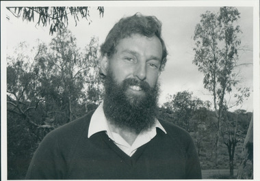 Uniting Church Archives - Synod of Victoria
Photograph, St Philip's College Alice Springs - Principal Chris Tudor & Deputy Principal Chris Eldridge, 09/1986
In 1945 the Reverend Harry Griffiths, who worked for the Methodist Inland Mission in Alice Springs, saw the need for a boarding facility for children of families living in remote areas in Central Australia who needed access to schools. He and his wife established Griffiths House, on a site in the town centre, and for many years it became home for students from all over the Outback, including many young Aboriginal people. In the late 1950's the Rev Fred McKay, successor to the Rev John Flynn as Superintendent of the Australian Inland Mission, lobbied the United Church in the Northern Territory to build and expand on this important start. Together the Presbyterian, Methodist and Congregational churches embarked on a missionary venture to develop St Philip's College - a new, larger residential hostel which would one day become a full boarding school. An ideal site - 22 acres of bush at the junction of the Charles and Todd Rivers and backing on to the Telegraph Station National Park - was secured and after six years of planning, construction began in 1964. Fred McKay led the legendary work parties comprised of volunteers from all over Australia who travelled to Alice Springs, paying their own way and volunteering their expertise, time and labour, to turn a dream into a reality. This fantastic tradition continues today, with work parties arriving each mid-year holiday. On 13 February 1965 the first boarders moved in to St Philip's College. For the first 24 years, therefore, St Philip's College operated as a residential hostel only. The College’s ninth Headmaster, Mr Christopher Tudor, arrived in 1986. He and the Council Chairman, Mrs Jan Heaslip, judged that the time was right to complete the original plan to turn St Philip’s College into a fully fledged independent boarding/day school, serving not only “bush” families, but also the growing population of Alice Springs. The then College Council embraced the idea and three years of frantic, determined preparation and planning commenced, culminating in an extensive $2 million building program in 1988. To this day there continues to be further development with the new landscaping underway near The Minnamurra Hall, Reception and Rivergum Cafe, plus the recent completion of the Science & Food Technology building and the new Rivergum Cafe.Head & Shoulders of Chris Tudor.st. philip's college, tudor, chris, eldridge, chris -
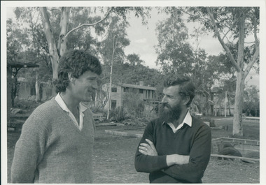 Uniting Church Archives - Synod of Victoria
Photograph, St Philip's College Alice Springs - Principal Chris Tudor & Deputy Principal Chris Eldridge, 09/1986
In 1945 the Reverend Harry Griffiths, who worked for the Methodist Inland Mission in Alice Springs, saw the need for a boarding facility for children of families living in remote areas in Central Australia who needed access to schools. He and his wife established Griffiths House, on a site in the town centre, and for many years it became home for students from all over the Outback, including many young Aboriginal people. In the late 1950's the Rev Fred McKay, successor to the Rev John Flynn as Superintendent of the Australian Inland Mission, lobbied the United Church in the Northern Territory to build and expand on this important start. Together the Presbyterian, Methodist and Congregational churches embarked on a missionary venture to develop St Philip's College - a new, larger residential hostel which would one day become a full boarding school. An ideal site - 22 acres of bush at the junction of the Charles and Todd Rivers and backing on to the Telegraph Station National Park - was secured and after six years of planning, construction began in 1964. Fred McKay led the legendary work parties comprised of volunteers from all over Australia who travelled to Alice Springs, paying their own way and volunteering their expertise, time and labour, to turn a dream into a reality. This fantastic tradition continues today, with work parties arriving each mid-year holiday. On 13 February 1965 the first boarders moved in to St Philip's College. For the first 24 years, therefore, St Philip's College operated as a residential hostel only. The College’s ninth Headmaster, Mr Christopher Tudor, arrived in 1986. He and the Council Chairman, Mrs Jan Heaslip, judged that the time was right to complete the original plan to turn St Philip’s College into a fully fledged independent boarding/day school, serving not only “bush” families, but also the growing population of Alice Springs. The then College Council embraced the idea and three years of frantic, determined preparation and planning commenced, culminating in an extensive $2 million building program in 1988. To this day there continues to be further development with the new landscaping underway near The Minnamurra Hall, Reception and Rivergum Cafe, plus the recent completion of the Science & Food Technology building and the new Rivergum Cafe.Tudor and Eldridge in conversation with the College in the background.st. philip's college, tudor, chris, eldridge, chris -
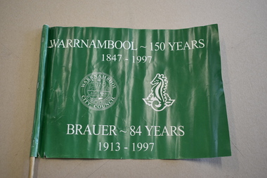 Warrnambool and District Historical Society Inc.
Artefact, Flag, 1997
This small flag has been made by Brauer College in Warrnambool to celebrate the 150th anniversary of the founding of Warrnambool and to mark the 84 years of Brauer College’s existence. Warrnambool was founded in 1847 as a planned town to provide port facilities for the export of produce of the local pastoralists and squatters. Brauer College began as the Warrnambool Technical School in 1913 with John King as the Principal and the original school buildings in Timor Street. In 1958 the school became the Warrnambool Technical College and today this site is occupied by the South West TAFE facility. The secondary school section of Warrnambool Technical College relocated to Caramut Road in Warrnambool and since 1990 has been known as Brauer College. It was named after a local prominent doctor and supporter of State Education – Dr Alfred Brauer. This flag is of some interest as a memento of Warrnambool’s 150th anniversary and of Brauer College’s part in this. This is a rectangular-shaped plastic flag attached with three metal staples to a circular-shaped wooden stick. The flag is green with white printing on both sides and contains the images of the Warrnambool City Council seal and the sea-horse emblem of Brauer College. The flag is partly torn away from the stick at the lower end. ‘Warrnambool -150 years 1847-1997’ ‘Brauer – 84 years 1913-1997’ brauer college, warrnambool, warrnambool’s 150th anniversary -
 Eltham District Historical Society Inc
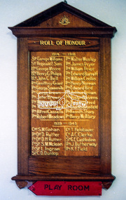
Photograph, Roll of Honour Board, Eltham War Memorial, 2005
This 1954 Roll of Honour board was an action of the WW2 Eltham War memorial Trust, for hanging in their Child Welfare Centre building on their property in Main Road, Eltham. The Johnstons Furniture Production Company made up the board and had the names of the local Eltham enlistees applied in gold lettering at a total cost of £13.10.00. The names were copied by the Eltham RSL from the obelisk which was first erected by the WW1 Eltham Peace Celebrations in August 1919 at the northwest corner of Bridge Street and Main Road. During road widening plans by the Council, the obelisk was moved to the garden area of the refurbished RSL branch building in Main Road for safekeeping. The Honour Roll Board was sent to the Eltham RSL sub-branch around 1999. Following the merger of the Eltham and Montmorency sub-branches and sale of the Eltham property, the obelisk was relocated to a location in front of the Eltham War Memorial. The Honour Roll Board was retrieved by former Eltham District Historical Society President, Harry Gilham in September 2004 who arranged for it to be hung in the Eltham War Memorial Hall (former Children's Library). It is attached to the brick wall face of the west (rear) wall of the Hall.Colour photo print and 18 photocopied and hand written mixed media pages1953, briar hill timber, cr. e.j. andrew, eltham rsl sub-branch, eltham war memorial, eltham war memorial hall, eltham war memorial trust, ernie andrew, harry gilham collection, honour roll, johnstons furniture production company, johnstons furniture productions, meeting minutes, minute book, montmorency-eltham rsl sub-branch, nillumbik shire council, roll of honour, stanley s addison collection, stanley simpson addison -
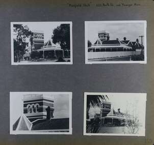 Glen Eira Historical Society
Album - Album page, Fairfield Hall, 225 North Road, Circa 1972
This photograph is part of the Caulfield Historical Album 1972. This album was created in approximately 1972 as part of a project by the Caulfield Historical Society to assist in identifying buildings worthy of preservation. The album is related to a Survey the Caulfield Historical Society developed in collaboration with the National Trust of Australia (Victoria) and Caulfield City Council to identify historic buildings within the City of Caulfield that warranted the protection of a National Trust Classification. Principal photographer thought to be Trevor Hart, member of Caulfield Historical Society. Most photographs were taken between 1966-1972 with a small number of photographs being older and from unknown sources. All photographs are black and white except where stated, with 386 photographs over 198 pages. Glen Eira Heritage Management Plan 1996 by Andrew Ward https://www.gleneira.vic.gov.au/media/4777/heritage_mment_plan_vol_3b.pdf (as of 27/01/2021) - p90 An imposing single storeyed Italianate bi-chromatic brick villa with three staged tower surmounting the entry and facetted corner bay with conical roof. White tuckpointed black body bricks are relieved with reds and stucco work. Gable ends are fretted and there is a concave cast iron verandah to the principal elevations.Victorian Heritage Database (as of 27/10/2020) - HO49 225 North Road Caulfield South https://vhd.heritagecouncil.vic.gov.au/places/42426 "Maniar" (?) is a substantial late Victorian Italianate villa with tower and extensive grounds built for Frederick Curwan, an inspector of the National Bank, in 1890. It is aesthetically and historically important. An imposing single storeyed ltalianate bi-chromatic brick villa with three staged tower surmounting the entry and facetted comer bay with conical roof. White tuckpointed black body bricks are relieved with reds and stucco work. Gable ends are fretted and there is a concave cast iron verandah to the principal elevations. It is aesthetically important as an imposing and substantially intact villa residence demonstrating the changing architectural fashions of the 1890's, evidenced by the use of face brickwork and fretted gables in the Queen Anne manner. It is historically important for the manner in which it demonstrates the lifestyle to which a businessman could aspire during the boom period.Page 150 of Photograph Album with four landscape photographs of Fairfield Hall on North Road.Handwritten: "Fairfield Hall" 225 North Rd cnr Younger Ave [top right] / 150 [bottom right]trevor hart, jenny o'donnell, verandah, porch, tower house, tower, mansion, three storey tower, bichromatic brickwork, fairfield hall, 1890's, george jobbins, conical roofed projecting corner bay, conical roofed bay, timber ceilings, north road, younger avenue, frederick wallis curwan, curwan, italianate, queen anne, australian homestead, arched windows, curved windows, columned parapet, return verandah, fairfield estate, fairfield street, slate roofed, red brick, polychrome bricks, victorian style, cast iron work, caulfield south, maniar, house names -
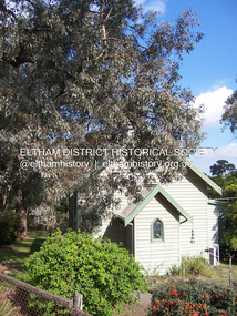 Eltham District Historical Society Inc
Photograph - Digital Photograph, Marguerite Marshall, Former Methodist Church, Plenty, 5 August 2008
In 1924, the Methodist Church opened at the corner of River Ave and Yan Yean Road, Plenty. It was a simple weatherboard gabled building. The church developed a strong community life with celebrations as well as worships, Sundays Schools and social events. It closed in 1979. Covered under Heritage Overlay, Nillumbik Planning Scheme. Published: Nillumbik Now and Then / Marguerite Marshall 2008; photographs Alan King with Marguerite Marshall.; p113 In 1924, the Methodist Church, (which closed in 1976), opened at the corner of River Avenue and Yan Yean Road. Church members including George Starling and Ernest Osmond, built the simple weatherboard gabled building.3 The church developed a strong community life, with celebrations as well as worship through Sunday School anniversaries, picnics, harvest festivals and youth groups. Many volunteers worked hard for the church - teaching Sunday School and ferrying young people to events, sometimes in the backs of trucks and furniture vans. Children from the Sutherland Homes were brought to church by their Matron – a ‘grim martinet’! Members included the Ashton, Reid, Harris, McLachlan, Hopkin, Rose and Stuchbery families. The first wedding was for Vida McLachlan and Ray Stuchbery.4This collection of almost 130 photos about places and people within the Shire of Nillumbik, an urban and rural municipality in Melbourne's north, contributes to an understanding of the history of the Shire. Published in 2008 immediately prior to the Black Saturday bushfires of February 7, 2009, it documents sites that were impacted, and in some cases destroyed by the fires. It includes photographs taken especially for the publication, creating a unique time capsule representing the Shire in the early 21st century. It remains the most recent comprehenesive publication devoted to the Shire's history connecting local residents to the past. nillumbik now and then (marshall-king) collection, methodist church, plenty -
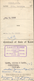 Bendigo Historical Society Inc.
Document - H.A. & S.R. WILKINSON COLLECTION: CONTRACT OF SALE
Contract of sale of land dated 28th November, 1958 between Mrs. V. Hunt (seller) and Mrs. L.M. Salis (buyer). Solicitor for vendor: Messrs. Hyett, Willis & Hyett, Bull Street, Bendigo. Solicitor for purchaser: Messrs. Watson, James & Rogers, Bull Street, Bendigo. For so much and such parts as lie above the depth of fifty feet below the surface of land being lot 1 on the vendor plan of subdivision situate at the corner of Victoria and Prout Streets, Bendigo part of allotment 420A section K land being delineated and colored red, blue and brown on the map in the margin hereof, together with all buildings thereon and with all floor coverings, internal and external blinds, curtains and electric light fittings and shades. Price 2,000 pounds.organization, business, h.a. & s.r wilkinson real estate -
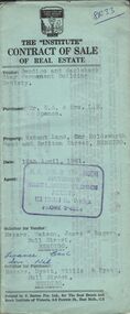 Bendigo Historical Society Inc.
Document - H.A. & S.R. WILKINSON COLLECTION: CONTRACT OF SALE
Contract of sale of real estate dated 12th April, 1961 between Bendigo and Eaglehawk Star Permanent Building Society (vendor) and Mr.E.A. & Mrs. L.M. Spence (purchaser). Solicitor for vendor: Messrs. Watson, James & Rogers, Bull Street, Bendigo. Solicitor for purchaser: Messrs. Hyett, Willis & Hyett, Bull Street, Bendigo. Property: vacant land corner Holdsworth Road and Britton Street, Bendigo being lot 3 on plan of subdivision No. 52449, having a frontage of 56 feet 7 inches with a width at the rear of 58 feet 5 inches with a depth of 97 feet 5.5 inches being part of crown allotment 31 section F at Bendigo described in Crown volume 8242 folio 057. Price 410 pounds.organization, business, h.a. & s.r wilkinson real estate -
 Port Melbourne Historical & Preservation Society
Photograph - Reference photographs, Port Melbourne, 1900 - 1999
Set of 14 reference photographs plus negatives of Government plans for Port Melbourne buildings and four photos of photos. .01- the Naval drill hall .02 - Naval drill hall East elevation .03 - West elevation .04- Front elevation .05 & .06- Court of Petty Sessions .07 &.08 - Watchhouse .09 - Drill Hall inner elevation .10 & .11 - Graham St School remodel .12 - Remodelling School 1427 .13 Naval offices front elevation .14 - Naval drill hall .15 - Post Office (original) .16 - Bay St shops Nettleton .17 - National Bank, Scott's, Nettleton .18 - Nott St School .19 - set of negatives (.19 at A06.03.B10) >15 to .18 are poor record photosbuilt environment - civic, national trust of victoria, royal navy of australasia -
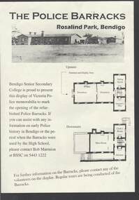 Bendigo Historical Society Inc.
Document - THE POLICE BARRACKS ROSALIND PARK BENDIGO
Pale yellow page containing a picture and upstairs and downstairs plans of the Police Barracks, Rosalind Park, Bendigo. On the back is the history of the building and it's use over the years since it was completed in 1860. On the 9 November 2002, the Bendigo Senior Secondary College presented a display of Police memorabilia to mark the opening of the refurbished Police Barracks. There were tours of the Barracks, displays and a Mounted Police display with horses. The Official Party was: Mr Graham Bastian, Principal, Bendigo Senior Secondary College, Mr Bob Cameron MP, member for Bendigo West, Ms Jacinta Allan MP, Member for Bendigo East, Ms Willi Carney, Mayor, City of Greater Bendigo, Mr Steve Gibbons MHR, Member for Bendigo and Mr Rob Blachford. There is a running sheet for the opening.buildings, government, police barracks, the police barracks rosalind park bendigo, bendigo senior secondary college, high school, bob marmion, p o flanagan, public works, alfred t snow, john robertson, bendigo goldfield, bendigo gaol, bendigo supreme court building, camp reserve, mounted constable james 'tiger' scholes 6438, education department, city of greater bendigo, graham bastian, willi carney, bob cameron mp, ms jacinta allan mp, steve gibbons mhr, bob blachford -
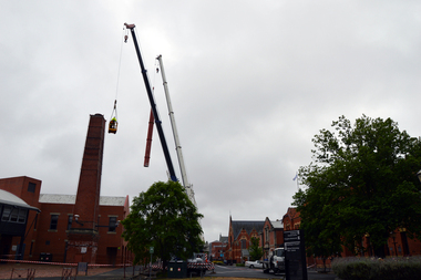 Federation University Historical Collection
Photograph - Colour, Phil Bryce, Removal of a fibre-glass chimney extension from a chimney from the former Ballarat Brewery, 2015, 13/11/2015
The chimney extension on what was the former Carlton and United Breweries boiler house at Ballarat installed in 1972 and it is constructed of a special formulation of fibreglass reinforced plastics designed to operate at elevated temperature (ie boiler flue gas). It is thought to be one of 26 or 28 fibreglass boiler chimneys designed and installed in Victoria in the 1970s, and is thought to be one of the last to be removed. In its day the fibreglass chimney extension was at the cutting edge of fibreglass technology and is therefore well worth retaining. Removal of the chimney extension to the brick chimney outside the brewery building was deemed necessary to prolong the life of the chimney, and also because the fibreglass extension had reached end of life and posing a possible threat. According an Engineering assessment, fibreglass structures have a life expectancy of between 20 years (when fatigue loaded) and up to 100 years (static loaded). We don’t know when it was added to the chimney but believe it was most likely in the early 1970s. Given that it is subject to wind load and often observed to be moving in the wind it is likely that it will be at the end of its life. The chimney will be made good and we have the necessary planning approvals in place to undertake the works. The chimney extension was removed on 13 November 2015 in accordance with a planning permit obtained by the University. The extension is believed to have been added in the 1970s and was predominantly made from fibre glass. The structure was removed for safety reasons and to preserve the integrity of the historic brick chimney which supported it. Coloured digital photographs associated with the removal of a fibreglass extension to a chimney which was part of the Former Ballarat Brewery/Carlton and United Breweries complex. Images also include the last day the chimney was in situ.chimney, fibreglass, former ballarat brewery, former carlton and united breweries, ballarat school of mines, brewery complex -
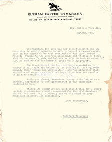 Eltham District Historical Society Inc
Folder, Eltham War Memorial Trust; Easter Gymkhana Committee Minutes, 19 Nov 1954-6 Jun 1958
Contents: Notice from Honoury Treasurer of Easter Gymkhana Committee regarding completion of 1954 event and expression of thanks and that committee is now going into recess prior to commencement of planning for 1955 Notice of Easter Gymkhana Committee Meeting, Monday 24th October, 1955 at the Shire Hall, Eltham Letter from B.T. Taylor, Hon. Secretary, Eltham Easter Show Committee regarding the sale of tickets (c.1957) Letter from B.T. Taylor, President, Eltham Easter Show Committee to Georges Ltd regarding the supply of The Georges Cup for the Eltham Easter Show, 11 April 1958 Letter from Georges Ltd to B.T. Taylor, President, Eltham Easter Show Committee with payment for the minitiares of The Georges Cup, 6 June 1958 Letter from Eltham Shire Secretary to B.T. Taylor, President, Eltham Easter Show Committee advising of new procxess regarding raffle, 5 May 1958 Letter from Lilian Heath, Secretary, Judge Book Village Auxiallary to B.T. Taylor, Eltham Easter Show Committee, 24 May 1958 Letter from Mrs R.J. Godfrey on behalf of M.A. Godfrey of Dandenong to B.T. Taylor, President, Eltham Easter Show under threat of legal action requesting replacement of cheque for £10 (second prize Open Jumping Contest), which was lost, 24 May 1958 Reply by B.T. Taylor, President, Eltham Easter Show Committee to Mrs R.J. Godfrey to her letter of 24 May explaining circumstances and denying responsibility to forward a replacement cheque as it was cashed at the Golf Club Hotel; 6 June 1958 History of the War Memorial Following the end of the First World War, communities across Victoria and Australia typically erected memorials which were predominantly statues, cenotaphs, avenues of honour and plaques. The Shire of Eltham established the Avenue of Honour at the gateway to the shire as well as an obelisk at the corner of Main Road and Bridge street and the Shire of Eltham War Memorial Tower at Kangaroo Ground. After the Second World War communities once again desired to preserve the memories of those who served and paid the ultimate sacrifice. Resources were scarce so there was a transition away from the traditional style memorials that sprang up post 1918 to one of building facilities that would provide ongoing benefit to the community. Even before the end of the Second World War, the citizens of Eltham began to consider an appropriate form of memorial for those from the area who fought and died in the First and Second World Wars. In 1943 the Eltham Women’s Auxiliary raised funds for the construction of buildings to be established on land to be purchased for the proposed War Memorial. On March 27th, 1945, the Eltham District Progress Association called a meeting of local people who in turn set up and registered the Eltham War Memorial Trust Inc. As a focus for the purpose of the memorial, the newspaper notice read:- ‘Those who have had a member of their family in the fighting services will want to see that the form of a memorial we are concerned with is the one which will be a constant reminder to us of those who fought for us and the little ones for whom they fought and died.’ At that meeting it was decided the Memorial should take the form of a baby health centre along with a creche and children’s library. In late 1945, the newly formed Eltham War Memorial Trust purchased the land at 903-907 Main Road Eltham from Miss Shillinglaw, which once formed part of the Shillinglaw farm on Lot 90 of Holloway’s 1851 “Little Eltham” subdivision. The Governor of Victoria, General Sir Dallas Brooks, laid the foundation stone on November 24th, 1950, in memory of those who fell in the Second World War. The Eltham Infant Welfare Centre was opened November 15th, 1952, the Pre-school on December 1st, 1956, and the Children’s Library in 1961. In late 1966 the children’s library service was integrated into the Heideberg Regional Library Service and the building was officially renamed the Eltham War Memorial Hall. Following the opening of the Eltham Infant Welfare Centre, work began in 1953 planning for the entrance to the grounds, which is signaled by a wrought iron arch entitled “Eltham War Memorial” . In 1954 the Eltham War Memorial Trust decided that a legacy provided by the late Councillor Ernest James Andrew (d. 29 March 1950) in memory of his wife, Mrs. Ellen Andrew (d. 13 July 1946) and who are both buried at Eltham Cemetery, should be used to fund the construction of the entrance. A metal plate inscribed to this effect was attached to the gates. Work on the Memorial Gardens was undertaken throughout the following decade, with a Memorial Forecourt included in the final 1956 plans for the Pre-School Centre. A quote was accepted by the Trust in 1963 for the implementation of a memorial garden, which included grading of a sixty-five foot strip at the rear of the Trust buildings and construction of concrete paths. The stone retaining walls at the front of the site were installed in 1968 when Main Road was widened and it is believed that the Memorial Gates were relocated at that time also. Eltham Senior Citizens Centre In 1964, Eltham Shire Council purchased a section of land from the Trust at the northern end of the site, as a provision for Country Fire Authority buildings. At the same time the Elderly Citizens Club proposed a Senior Citizens Centre on the south western section of the Trust’s property. This was approved by the Trust with the provision that the building was constructed in ‘accord’ with those already existing. In 1965 Council took on board the plans for the Senior Citizens Centre and applied for a government grant. These could only be awarded if Council owned the site. In 1962 the Trust had resolved to hand over the assets to Council once the Memorial Gardens were completed. This was in line with Health Department requirements that grants for the ongoing operation and maintenance of the three facilities would only be made once the the facilities were completed and handed over to Council. In 1965 the Department of Health further demanded substantial alterations to the Pre-School playground as a result of the pending impact of the planned Senior Citizens Centre and Main Road duplication. As a consequence, handover of the Trust’s assets to Council was initiated with a formal ceremony held in the Children’s Library on August 28th, 1965. The Trust continued on as a committee of management for another twelve months. Plans and specifications for the Senior Citizens Centre were prepared by March 1966. Council obtained a grant from the Government which covered one third of the cost and the building was completed by April 1967. Whilst the Senior Citizens Centre is contained within the original Eltham War Memorial building precinct, it was not part of the original Memorial and was not funded by the Eltham War Memorial Trust.Nine copies of letters/notices inserted loose in Minute Book, 33 x 21 x 1 cm, green faux crocodile skin hard board end-covers with black spine binding; 82 pages (last 38 blank)b.t. (ben) taylor, easter gymkhana committee, eltham war memorial trust, georges ltd, golf club hotel, judge book village auxilliary, lilian heath, minutes, r.j. godfrey, the georges cup -
 Eltham District Historical Society Inc
Photograph - Digital Photograph, Marguerite Marshall, Wingrove Cottage, Main Road, Eltham, 8 June 2006
Wingrove Cottage built 1858-1859 of hand made bricks is historically significant for its long association with Charles Wingrove, a prominent figure in Victorian local government, as secretary to the Eltham District Road Board and Shire Council from 1858 to 1904, and Shire Engineer and Secretary to the Heidelberg Road Board. The cottage was used as the office of the Eltham District Road Board and Council for many years It is one of the Shire's oldest dwellings, and one of the few surviving 19th century buildings associated with early Eltham and located in the original Eltham Village Reserve. The symmetrical planting of a pair of Pencil Pines (not visible in photo) is also historically and aesthetically significant as characteristic of the early period of planting in the district and because they are a distinctive landscape feature. In October 2002 new owners demolished the outbuildings attached to the rear of the cottage. Community protest at the demolition resulted in Council issuing a Stop Work order. The owner was issued with a court order in September 2003 to develop a conservation management plan and restore the heritage listed property. The owner sold the property in 2005 to Cameron Construction in 2005 who undertook the restoration work. In 2007 a planning application to build two offices and seven dwellings at the rear of the property was ultimately rejected. The cottage is now the main office for Cameron Construction. Covered under Heritage Overlay, Nillumbik Planning Scheme. Published: Nillumbik Now and Then / Marguerite Marshall 2008; photographs Alan King with Marguerite Marshall.; p57 Wingrove Cottage on Main Road beside Eltham Primary School, is one of the Shire’s most important historical buildings and was central to local government for almost 50 years. The cottage was built in stages from 1858 to 1888 for Charles Symons Wingrove JP. He was the Eltham District Road Board’s first paid secretary and later the Shire Secretary when the board became the Eltham Shire Council. Wingrove held those positions, and that of engineer for a time, for 46 years. He was also one of the main figures in the Municipal Association of Victoria. As Eltham’s first paid municipal officer, Wingrove used one room in his 11 – (originally two) roomed home, as the office for the board then the council. Meetings were held there from the late 1850s (as well as at more central locations) until Wingrove’s retirement in 1904. The cottage is a rare example of a local government office occupying a Road Board /Shire Secretary’s purpose-designed house. The cottage is also significant because it is the oldest largely intact building from the original Eltham township reserve (south of Dalton Street).1 The township had its origins in the 1848 Nillumbik Parish Plan and was one of the state’s earliest township reserves. The rectangular house of handmade bricks, roofed with grey slate tiles and with a veranda encompassing three sides, is reminiscent of those in the central goldfields including Castlemaine. Its overhanging eaves and gables were unlike houses in Melbourne at the time. Wingrove, who was born in 1827, had been a gold digger and a road surveyor. Impossible to imagine in today’s world, Wingrove was also the Shire of Heidelberg’s secretary and engineer for part of the time that he was secretary in Eltham. Living next door to the primary school was a mixed blessing. Wingrove and his wife Katherine, who had ten children, sent their eight surviving children to the school. But they had occasional disputes with the school authorities when their cattle wandered into the schoolyard. Eltham showed Charles Wingrove its appreciation of his services by giving him two illuminated addresses, one after ten years and the other at retirement. Wingrove died in 1905 aged 76 and was buried in the St Katherine’s Church of England cemetery in St Helena. His grave is surrounded by those of family members including his wife, Katherine and two babies, Henry, 12 months and Isobella, 15 months, who died in the mid-1860s. Cottage ownership passed to his wife, then to daughter Caroline and then to daughter Bessie, a Melbourne University graduate and artist. During the Great Depression their brother Walter was the ratepayer. At one stage the Wingrove property extended to Metery Road and included a small creek. The family ran a small dairy and orchard, with associated farm buildings, which were later removed. In 1949 part of the property was compulsorily acquired by the Eltham Primary School, which infuriated owner Bessie Wingrove. She protested in a letter about this ‘monstrous act of unmitigated tyranny’.2 She was the last Wingrove to occupy the cottage and died in 1955. Wingrove descendants sold the house in 1974 and the property was subdivided. In the 1960s the Eltham Shire named the park opposite the cottage in Wingrove’s honour. The cottage has since had several owners including psychiatrist Dr Daniel Kahans, who practised there. In October 2002 late rear additions which had been substantially altered were demolished contrary to council planning controls. This caused a community outcry and resulted in legal proceedings against the owner. Fortunately the historical significance of the demolished section was not as great as the older front part of the building, which has been retained and was later restored.This collection of almost 130 photos about places and people within the Shire of Nillumbik, an urban and rural municipality in Melbourne's north, contributes to an understanding of the history of the Shire. Published in 2008 immediately prior to the Black Saturday bushfires of February 7, 2009, it documents sites that were impacted, and in some cases destroyed by the fires. It includes photographs taken especially for the publication, creating a unique time capsule representing the Shire in the early 21st century. It remains the most recent comprehenesive publication devoted to the Shire's history connecting local residents to the past. nillumbik now and then (marshall-king) collection, cameron construction, charles symons wingrove, eltham, eltham road district board, eltham shire council, main road, wingrove cottage