Showing 2828 items
matching government roads
-
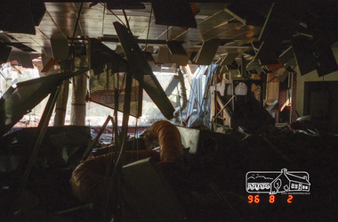 Eltham District Historical Society Inc
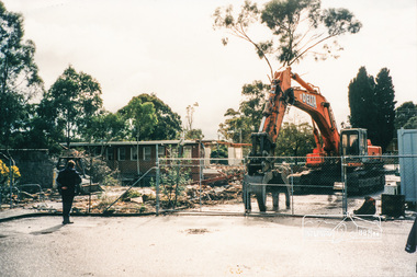
Photograph, Demolition of the former Shire of Eltham building, Main Road, Eltham, 2 Aug 1996, 1996
The Shire of Eltham Office was constructed in the late 1960s on the original site of Shillinglaw Cottage. Upon cessation of the Shire as a local government body following dismissal of councils by the Kennett Liberal Government in December 1994, the new Nillumbik Shire offices were located in Civic Drive, Greensborough. The Shire of Eltham office building was demolished and the site has remained vacant ever since. The three pine trees which featured in front of Shillinglaw Cottage and then the Shire of Eltham Offices remain standing on the vacant site as of 2017. Roll of 35mm colour negative film, 7 stripsKodak Gold 100-5eltham, main road, shire of eltham, shire of eltham office -
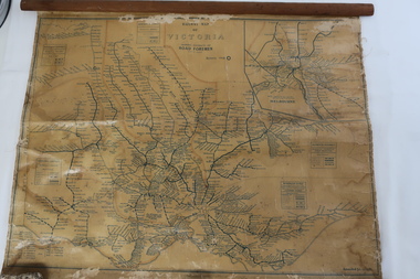 Kiewa Valley Historical Society
Map - Railway Map of Victoria, Amended to 1/11/1945
Railways began in the 1850s and were privately owned and operated. Later they were taken over by the Victorian Government reaching a peak in the early 1940s.Steam trains were followed by electric trains with both running after the war in 1945.Bright was the closest station to the Kiewa Valley but road transport was used more often as the Kiewa Valley Highway was improved with the construction of the Kiewa Hydro Electric Scheme. To travel to Melbourne or Sydney by train residents went via Wodonga/Albury where they also did their shopping.Plastic on parchment with detailed railway routes (in green) across Victoria including each district's 'Road Foremen' and 'Depots'. There is a length of flat wood attached by 10 tacks across the top of the mapvictorian railways 1945, trains, transport -
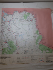 Kiewa Valley Historical Society
Map - Road Construction Authority 1986, Ref. Tallangatta 282008
Government authorities updated maps regularly.Historically of interest eg. 1. Pre dates the Alpine National Park. 2. 'Mt Beauty Estates' now known as Tawonga South. 3. Mt Niggerhead is named - It is now known as Mt Jaithmathang having been renamed in 2009.Colored map dated 1986 titled Road Construction Authority with an update of roads in the local Shires. It names places in the area and has a legion describing the rating of the roads and tracks. It also shows the main towns in the area and their roads.road construction authority, map of tallangatta area -
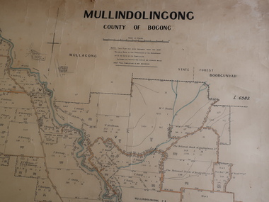 Kiewa Valley Historical Society
Parish Map - Mullindolingong, County of Bogong
The Department of Lands regularly updated the occupiers with leases or licences of the land.The names of the early settlers of the Kiewa Valley occupying land by lease or licence are shown. Many of these familie's descendants still live in the Kiewa Valley.Government (Lands Department?) cloth map showing the leases or licenses of occupiers of the land in the valley. The Kiewa River is shown in blue and roads in yellow. There is no date on the map.parish of mullindolingong map, settlers of the kiewa valley -
 Eltham District Historical Society Inc
Magazine, Sun News-Pictorial, Bush Fires: A pictorial survey of Victoria's most tragic week, January 8-15, 1939, 1939
THE WEEK REVIEWED (Article; Bush Fires: A pictorial survey of Victoria's most tragic week, January 8-15, 1939. Published in aid of the Bush Fire Relief Fund by the Sun News-Pictorial in co-operation with its newsagents, pp2-3) THE fiercest bush fires Australia has known since its discovery are quiescent at the moment, and Victoria, in the comparative coolness of the change which came with rain on Sunday night, has begun·to count its losses. In the fiery eight days, from Sunday to Sunday, at least sixty-six men, women and children have lost their lives in forest fires, or have succumbed to burns and shock; many others have died from heat; and several serious cases of burns are being treated in hospitals. Two babies in Narrandera district have died, and ten others are in hospital, because of milk soured by the record temperatures of those eight days. Forest damage totals at least a million pounds, and incalculable damage has been done to the seedlings which were to have been the forests of the future. Water conservation will be seriously affected by the silting-up of reservoirs and streams from which protective timber has been taken by the all-engulfing flames. More than a thousand houses have been destroyed, and these, with 40 mills, and schools, post-offices, churches, and other buildings, represent a loss of at least half a million. At least 1500 are homeless. For their aid, money raised in appeals has now passed the £50,000 mark, and the biggest relief organisation ever set up in peace time has swung into operation. The First Hint Victoria's first hint of what was to come appeared on Sunday, January 8, when most parts of the State awoke to find a blistering day awaiting. At 12.20 p.m., when the thermometer reached its highest for the day, 109.6 degrees, the first fire victims were at that moment going to their death on a bush track five feet wide off the main road to Narbethong. They were the forestry officers Charles Isaac Demby and John Hartley Barling, who went to warn Demby of his danger when he parted from his companions, and was himself surrounded by the treacherous fire. It was not until 8 o'clock next morning that the tragic news was flashed throughout the State. Searchers found the two charred bodies close together, one seeking protection in the nook of two logs. Barling's watch had stopped at 1.20. In the meantime, tragedy was spreading its cloak. By Monday, big fires were raging at Toolangi, Erica, Yallourn, Monbulk, Frankston, Dromana, Drouin South, Glenburn, and Blackwood, with smaller outbreaks at many other centres. In the ensuing week, while women and children were evacuated as fast as the flames would permit, Erica-scene of the 1926 fire disaster-thrice escaped doom by a change of wind. Indeed, those who have been in the fire country these past days say that the numbers of times a change of wind has saved towns from destruction is amazing. In the towns they speak of miracles. Monday's Miracles The escapes from Monett's Mill at Erica and from the Hardwood Company's Mill at Murrindindi, near where Demby and Barling went to their death, were Monday's miracles. Twenty came out alive from each mill. At the first a 60ft. dugout provided an oven-like refuge; at the second, 12 women and children survived in the smoke-filled gloom of a three-roomed cottage while their eight men, their clothes sometimes afire, poured water on the wooden walls. Three houses out of ten remained when the fire had passed. Record Temperatures Sunday had been the hottest Melbourne day for 33 years; Monday dropped to a 76.1 degree maximum; but Tuesday dawned hotter than ever, the mercury reaching 112.5. By now rumor was racing ahead of fact; whole towns were being reported lost; the alarm was raised for scores of missing persons. But fact soon overtook rumor, and within a few days the staggering toll began to mount to a figure beyond the wildest imaginings of the panic-stricken. Six died from heat on this torrid Tuesday, and the fires spread in a wide swathe from south-west to north-east across the State. Fish died in shallow streams. A curtain of smoke hid the sky from all Victoria, and hung far out to sea. It alarmed passengers on ships. On the Ormonde, on the voyage to Sydney from Burnie, women ran on deck, believing fire had broken out in the hold. Days later the smoke reached New Zealand. In Melbourne thousands of fire-volunteers were leaving in cars: vans, motor-buses-anything reliable on wheels-to aid the country in its grim fight. In the fires at Rubicon and. Narbethong, seventeen were facing death this day. But not till Wednesday, when Melbourne breathed again in a cool change, while the country still sweltered in temperatures up to 117 degrees, did the news come through the tree blocked roads. A woman and her little daughter, trapped on the road, were among those who died. Their bodies, and those of menfolk with them, were found strewn out at intervals along the road, where the furnace of the surrounding fire had dropped them in their tracks as they ran. Twelve died at a Rubicon mill, five on the road at Narbethong. At Alexandra, not far distant, a baby was born while the fires raged, and stretcher-bearers brought in the injured. On Thursday the State Government voted £5000 for the relief of fire victims. The Governor (Lord Huntingfield) and the Lord Mayor (Cr. Coles) visited some of the stricken areas, and dipped into their pockets personally. Later, the City Council, too, voted £5000. Friday, The 13th Friday, the Thirteenth, justified its evil name. A blistering northerly came early in the morning, presaging destruction, and forcing the mercury to a new record of 114 degrees. Racing fires killed at least ten in those terrible 12 hours. Four children were engulfed in the furnace at Colac. Panic drove them, uncontrollable, into the smoke-filled road when the fire raced down behind their home. They choked to death. In other parts fires were joining to make fronts of scores of miles. Kinglake was being menaced on two fronts, £60,000 worth of timber was going up in smoke in Ballarat district. Warburton was surrounded. Residents at Lorne, favoured resort, were being driven to the sea-front by a fire which destroyed at least 20 homes. Healewille. with flames visible from the town at one stage, was in a trough between two fires which burned four guest-houses, seven homes and left its surrounding beauty-spots wastes of bowed-over, blackened tree-fern fronds; with its famous Sanctuary, however, intact. Most of Omeo was destroyed this black day: Noojee. while 200 residents crouched in the river, was being reduced to a waste of buckled iron and smoking timber; Erica was once again saved by a change of wind. Beneath a pall of smoke, the Rubicon victims were buried at Alexandra. Friday night and the early hours of Saturday saw the streets of beleagured towns strewn with exhausted fire-fighters. Their flails beside them, ready for the next call, they lay where exhaustion overtook them-on footpaths, beside lamp-posts, in gutters, in cars, under trucks. Saturday's dawn brought clear skies and lower temperatures in many parts, and from the burnt-out areas came a great rush of tragic reports. The death-roll rushed past the fifty mark with incredible speed. Some had been trapped on roads, others at mills; some, after burying their treasures, had clung too long to the places they had made their homes for many years. Four men lost their lives because one went back for his dog. By Sunday, when the first of the saving rain came, nearly another score of names had been added to the list.Newspaper magazine, 48 pages (incl. covers). Fully digitised and searchable PDFPublished in aid of the Bush Fire Relief Fund by the Sun News-Pictorial in co-operation with its newsagents.bushfires, 1939 bushfires, black friday, warrandyte -
 Eltham District Historical Society Inc
Photograph, Demolition of Eltham Shire Offices, 17 Aug 1996, 17/8/96
Three colour photographs of the Shire of Eltham Council Offices, Main Road, Eltham being demolished. 17 August, 1996. This followed Victorian Local Government re-amalgamations in 1994. This was a multi-story building which also included the Eltham Library.shire of eltham, demolition, buildings -
 Doncaster RSL Sub Branch
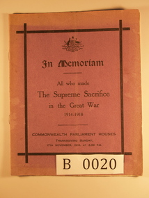
Thanksgiving Program, Late 1918
Program of Thanksgiving Sunday 17th November 1918 3-30 pm Commonwealth Parliament House. Faded purple outer cover with black printing. Five inner white pages with program details By Authority: H J Green Acting Government Printer, Melbourne -
 Warrnambool and District Historical Society Inc.
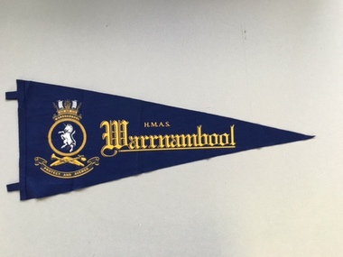
Flag, HAMS Warrnambool, 2005
This is a souvenir pennant of the H.M.A.S. Warrnambool, named after the City of Warrnambool in Victoria. This ship was the second of that name. The first H. M.A.S. Warrnambool, launched in 1941, was one of 60 Bathurst-class corvettes commissioned by the Australian Government. It was involved in mine clearance work in the Great Barrier Reef after World War Two. The mines had been laid by the Australian Government during the war to protect Australian waters. In 1947 the first H.M.A.S. Warrnambool was sunk by one of these mines and lies on the ocean floor off Cockburn Reef in northern Queensland. The second H.M.A.S. Warrnambool was commissioned in 1981 and was a Fremantle-class patrol boat assisting in capturing illegal fishing boats and participating in military exercises in Australian waters. In 2005 the second H.M.A.S. Warrnambool was decommissioned after 24 years’ service. This pennant is important as a souvenir of the H.M.A.S Warrnambool, a ship that had obvious links with the City of Warrnambool. In 2005 the Mayor of Warrnambool, Glenys Phillpot, attended the decommissioning of this ship at Darwin and brought back several souvenirs of the ship. This is a triangular-shaped pennant made of dark blue felt material. It has stitching at the straight edge with two tabs for attaching the pennant to a pole or post. The pennant has a badge of yellow, black and white tonings printed or stamped on to the felt. The badge includes a white unicorn, a stylized ship and crown, a boomerang and two other implements and the motto, ‘Protect and Avenge’. The words, ‘H.M.A.S. Warrnambool’ are printed on the pennant in yellow. ‘H.M.A.S. Warrnambool’h.m.a.s. warrnambool, history of warrnambool -
 Warrnambool and District Historical Society Inc.
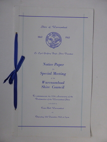
Document, Collett and Bain, Notice of meeting Warrnambool Shire, 1963
This booklet commemorates the 100th anniversary of the proclamation of the Shire of Warrnambool. The original proclamation was read from the Government gazette 13/12/1863 Pg 2958. This follows from being proclaimed a roads district in 1854 which was then partly portioned and proclaimed the Municipal district in 1855. Portion of the shire was again annexed to the city in 1955. The Warrnambool shire covers the area on north east and western sides of the city of Warrnambool covering approximately 600 square miles and has a rich history of farming and dairy products. A program which commemorates 100 years of the shire of Warrnambool. It contains a comprehensive list of councillors who served during that time.White light card cover with royal blue text and tied with royal blue ribbon.Pale blue vertical lines. Shire crest with dates either side at top centre of page.Back cover has list of councillors names who have served from 1863 up to 1963. Photographs in green tinge inside front and back covers. 8 pages. Cr Cyril Geoffery Boyle. Thursday 12th December 1963.Mr Robert Burke, Cr C S Brown, Cr C G Boyle, A F Ponting,The Honourable Murray Porter, Hon R W Mack, Cr J Pascoe, Mr J W Crawley, Mr L Crawley, J Wm Crawley, Jnr, R L Crawleywarrnambool,, warrnambool shire, cr c g boyle, warrnambool shire 1863, warrnambool shire 1963 -
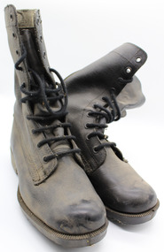 Warrnambool RSL Sub Branch
Boots Army - left boot, 1980's
These boots were used by the military in Australia during period when there were no active conflicts.Typical of boots worn by military personnel during the nineteen eighties.military boots black leather, front lacing with ten eyelets, mid calf length, rubber sole imprinted with ROSSI and 7/6 Rubber sole ROSSITERLTD FOOTWEAR Made in Australia. Black cotton laces.label. inside boot top. R251 with vertical arrow below (arrow indicates government ownership). On right 7/6, B69 below. On Rubber Sole, impressed lettering 'Rubber Sole ROSITER LTD FOOTWEAR made in Australia. 7,6 stamped on instep of solemilitary boots, army boots, footwear, military uniforms -
 Warrnambool RSL Sub Branch
Boots Army - right boot, 1980's
These boots were used by the military in Australia during period when there were no active conflicts.Typical of boots worn by military personnel during the nineteen eighties.military boots black leather, front lacing with ten eyelets, mid calf length, rubber sole imprinted with ROSSI and 7/6 Rubber sole ROSSITERLTD FOOTWEAR Made in Australia, Black cotton laces. label. inside boot top. R251 with vertical arrow below (arrow indicates government ownership). On right 7/6, B69 below. On Rubber Sole, impressed lettering 'Rubber Sole ROSITER LTD FOOTWEAR made in Australia. 7,6 stamped on instep of solemilitary boots, army boots, footwear, military uniforms -
 Warrnambool RSL Sub Branch
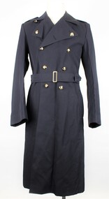
RAAF Gaberdine Overcoat, Australian Government Clothing Factory (A.G.C.F.), 1976
This coat was issued to Airman Bernard Farley in 1976 as an initial issue of uniform. Bernard was enlisted in the Royal Australian Air Force in Warrnambool on 26th January 1976. This item is a Royal Australian Air Force uniform that was issued for the airman Bernard Farley. It has historic and social significance as an item of local military history. It is also in near perfect condition.RAAF Blue Gaberdine Greatcoat/Overcoat. Double Breasted. Belted at waist. Partly lined inside body; sleeves fully lined. Two vertical pocket openings at belt height give access to large inner pocket and to separate inner clothing. Double line of 5 Gold coloured plastic(?) buttons with Crown and Wingson on left and right front of coat. Single black plastic button on inside of coat immediately behind top left gold button. Epaulettes on shoulders are attached at outer end and have a small gold coloured button and button hole attachment at inner end; 'RAAF' sewn in lighter blue thread on outer end of each epaulette. Sleeves have 3 small gold buttons on cuffs.Attachment inside collar reads; A.G.C.F. (Australian Government Clothing Factory) Vic 1976. Broad Arrow Symbol. 8405.66.013.6603. Size 3L. No. NAME. Attachment inside lower left reads; handwritten, 17481, E746813, 3L,30560. 27.Blue Stamp - S broad arrow Nraaf, great coat, royal australian air force, r.a.a.f., air force, uniform, coat, bernard farley, farley, airman, warrnambool, warrnambool rsl -
 Warrnambool RSL Sub Branch
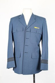
TUNIC - RAAF (Blue Grey) Service Dress Uniform Jacket, Military Uniform, 1998
This item of military uniform was worn by Squadron Leader (SQNLDR) Bernard Farley during his period of Full Time service in the Royal Australian Air Force (RAAF) between 27 January 1976 and 02 March 1997. Bernard joined the RAAF as an Airmen was trained and employed as a Clerk Supply (CLKSPL) between 1996 - 1977. He undertook officer cadet training at the Army Officer Cadet School in 1978 and was commissioned into the Ground Defence Category on the 09 December 1978, where he served for 18 years and rose to the rank of SQNLDR. Royal Australian Air Force (RAAF) 1A Service Dress Uniform 1A - Tunic (Jacket - Blue Grey). This uniform was in the period 1966 - 2001 as the primary uniform. Service Dress is approved for wear as either ceremonial dress or working dress when employed in office or business type environments. The Tunic consists of a jacket has a lapel collar, with two external chest pockets and exposed pocket flaps, two side jacket pockets with external flaps and two internal jacket pockets positioned just below the external chest pockets. There is a crescent shaped cloth badge 'AUSTRALIA' sown at the side/top of each sleeve and Squadron Leader - rank stripes sown around each sleeve on the upper wrist area. The Tunic is closed with four gold buttons down the front. Each button is inserted through a small round hole sewn into the right side of the tunic front and held in place at the rear with a safety pin. There are four corresponding button holes sewn into the left front of the tunic to fasten the jacket in the normal closed position when worn. Maker: Australian Government Clothing Factory (A.G.C.F.) - Coburg Victoria The Tunic has two military decorations attached above the exterior left chest pocket. The decoration are: 1. Conspicuous Service Medal - Yellow and Green right sloping diagonal strips 2.. Defence Service Medal (with one clasp) - Blue and Gold upright stripes and round metal clasp positioned centrally. The DSM is awarded for 15 years service and a clasp is awarded for each additional 5 years service. -
 Warrnambool RSL Sub Branch
TROUSERS - RAAF (Blue Grey) Uniform, Military Uniform, 1988
This item of military uniform was worn by Squadron Leader (SQNLDR) Bernard Farley during his period of Full Time service in the Royal Australian Air Force (RAAF) between 27 January 1976 and 02 March 1997. Bernard joined the RAAF as an Airmen was trained and employed as a Clerk Supply (CLKSPL) between 1996 - 1977. He undertook officer cadet training at the Army Officer Cadet School in 1978 and was commissioned into the Ground Defence Category on the 09 December 1978, where he served for 18 years and rose to the rank of SQNLDR. Royal Australian Air Force (RAAF) trousers- Blue Grey. This uniform was in the period 1966 - 2001 as the primary daily uniform in the office environment. Polyester working dress is approved for wear employed in office or business type environments. The trousers have a belted waist and zip front, with two slant side pockets, money fob pocket below the waist on right side and two rear slit pockets. The trouser leg is pleated at the waist belt in the front. Maker: Australian Government Clothing Factory -
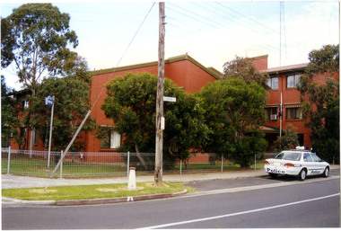
 Victoria Police Museum
Police Stations (Anglesea)
Anglesea is a town on the Great Ocean Road in the Surf Coast Shire local government area. It is 110km from Melbourne. Before 1967 policing in Anglesea was on a seasonal basis with a 'shop front' police station and caravan in the main street. Anglesea Police Station (Barwon District) was opened on 7 February 1967 on the corner of Wray Street and The Great Ocean Road. It was a residential police station, brick veneer with an iron roof with 3 rooms, a bathroom, laundry and a garage. When the station opened it was staffed by one Senior Constable and two First Constables. List of staff from 1967-2002 is available from Victoria Police Museum10 photographs comprising: 8 black and white photos, 2 colour photospolice stations; anglesea police station -
 Victoria Police Museum
Police Stations (Altona North)
Altona North is a suburb of Melbourne, Victoria, Australia, 10 km south-west of Melbourne's Central Business District, located within the City of Hobsons Bay local government area. Altona North Police Station opened on 7 October 1979 as a new twenty-four police station and was the District Headquarters of Altona District. It comprised a C.I.B. and a Community Policing Squad. It is located at 72 Cooper Avenue, on the corner of McArthurs Road. A new police station is being planned for Galvin Street, opening in 2020.2 colour photospolice stations; altona north police station -
 Victoria Police Museum
Police Stations (Armadale)
Armadale is an inner suburb of Melbourne, Victoria, Australia, 7 km south-east of Melbourne's Central Business District, located within the City of Stonnington local government area. Armadale Police Station opened, in Melbourne Police District, on 11 May 1885. Its original location is unknown, but in 1890 it is listed in the Sands & McDougall directory as at 295 Hight Street. From 1985-1920 it was located at 20/22 Auburn Grove, 1925-1930 at 769 High Street and 1935-1946 at 3 Cheel Street. The station closed on 28 January 1946. The sub-division east of Orrong Rd was incorporated into Malvern Sub-district and west of Orrong Road into Prahran Sub-district. In a special 1930 issue of the Victoria Police Gazette the Armadale Police Station was described as a seven-roomed brick dwelling with a tiled roof on land measuring 127' x 104' x 98'. There was also a bathroom and W.C., a wash-house, office, and a lock-up (one cell). This is probably a description of the Cheel Street police station. It was staffed by one senior constable and three foot constables.12 photographs comprising 8 coloured images and 4 black and white images 1 sketch plan of Old Armadale Police Stationpolice stations; armadale police station -
 Victoria Police Museum
Police Stations (Ascot Vale)
Ascot Vale is an inner suburb 6 km north-west of Melbourne, Victoria, Australia in the local government area of the City of Moonee Valley. Ascot Vale police station was opened on 31 October 1887 in the Melbourne Police District. From 1900-1905 it was located at 54 Parade, Ascot Vale; from 1910-1925 at 71 St Leonards Road; from 1930-1953 at 37 St Leonards Road. In 1953 it was relocated to government owned premises at 111 Union Road until the police station closed on 1st May 1970 and the Sub-district was divided between Flemington and Moonee Ponds police stations. The former police station was used by the Crime Car Squad until about 1987 when the premises were damaged by fire. The police station at 37 St Leonards Road was described as a six-roomed brick dwelling with slate and iron roof on land measuring 150' x 50'. There was also a bathroom and W.C., wash-house, office and lock-up with one cell. It was staffed by one second-class sergeant and four foot constables. The purpose-built police station at 111 Union Road included a four-roomed residence with the exterior clad in rough cast Conite and a tile roof. There was also a kitchen, bathroom, laundry and separate garage. 4 black and white photospolice stations; ascot vale police station -
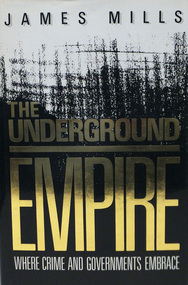 Warrnambool RSL Sub Branch
Book, THE UNDERGROUND EMPIRE. Where Crime and Governments Embrace
Hard Cover with dust cover Author; James Mills (on dust cover)Publisher: Sidgwick & Jackson Limited London:1987 -
 Warrnambool RSL Sub Branch
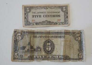
Memorabilia - WW2 Japanese money issued during the occupation of the Phillipines, Occupation Money Japanese in the Phillipines
paperBlue-Gray colour-THE JAPANESE GOVERNMENT, FIVE CENTEVOS. PP in Lower right and left, Reverse 5 in centre. Sandy Brown colour- THE JAPANESE GOVERNMENT, FIVE PESOS. 5 in centre and each corner, Upper Right 0050616. Lower Left 1391. Reverse PESOS and rows of 5's in pattern -
 Warrnambool and District Historical Society Inc.
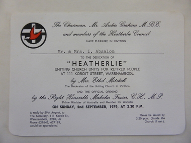
Document - Invitation, Heatherlie Homes opening 1979, Circa August 1979
"Heatherlie " homes have been extended and are still operated under the auspices of the Uniting Church Australia. Invitation retained by Absalom family members for 44 years. "Heatherlie" name originated from owners of wooden house built by EB Phillips, furniture store owner. Name taken from mrs Annie Phillips (nee Bone) family home in Stawell.Original document, invitation to dedication of "Heatherlie" by Mrs Ethel Mitchell, Moderator of Uniting Church in Victoria and the official opening By the R Hon Malcolm Fraser, PM of Australia and Member of Wannon. Significant as "Heatherlie" was a community and government funded building programRectangular white card with rounded corners. Black print with black and red logo, Uniting Church. Typewritten name, Mr. & Mrs. I. Absalom. Varied size print, copperplate, capital letters and typewritten name inserted.Logo of Uniting Churchmr archie graham, mr & mrs i absalom, uniting church, warrnambool, mrs ethel mitchell-moderator, malcolm fraser pm, of australia, koroit street, heatherlie council -
 Warrnambool and District Historical Society Inc.
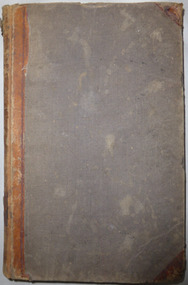
Document - Ledger: Correspondence and reports Country Roads Board , Shire of Warrnambool 1914-1925, Circa 1914
The letters contained within this ledger provide an overview of correspondence which occurred around matters such as roadmaking and maintenanceProvides a detailed record of correspondence relating to engineering matters in the shire and surrounds and also a comprehensive list of organisations associated with this work.Dark blue watermarked cover with fawn suede binding and corners. Spine has three coloured rectangles with the following in each: Correspondence and reports, Country Roads Board and Shire of Warrnambool. There is an index at the front and the ledger contains copies of correspondence relating to roads, maintenance and infrastructure.Inserted in ledger is1) typed invoice from The Government of Victoria to Shire of Warrnambool for 1915/16, 2) Original of two pages showing list of contracts on Garvoc Laang Road. Arnall and Jackson, Engravers and Lithographers. Printers and Manufacturing stationers 478 Collins Street, Melbourne. No B 22065 23/09/14. warrnambool, warrnambool shire engineer, shire correspondence, crawley, road works, bridges, bitumen roads, 1914-1925, country roads board -
 Warrnambool and District Historical Society Inc.
Document - Ledger: Warrnambool Shire Correspondence Letter Book, 1871-1875, Circa 1870
A detailed continuum of correspondence showing the progress of development in the district and the co-operation and cost sharing between the different shires to have work completed. This collection of letters provides a very good overview of issues and work covered in the early settlement days of the district. Cover is brown watermarked patterned cloth with tan suede binding and corners. Inside front and back covers is green and red patterned paper. Alphabetical index at the front. The ledger contains copies of letters which were written to local shires and lands Departments and relate mainly to matters of infrastructure and local government charges There are a number of invoices at the back of the book.: Letter Book No. on spine. Gold lettering on red. Serial numbers, signatures, engravings, dedications in books, manufacturing details or personal markingswarrnambool, warrnambool shire, hampden shire, mount rouse shire, geelong to belfast road, alfred davies, 1873-1875, shire correspondence -
 Warrnambool and District Historical Society Inc.
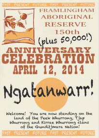
Booklet - 150 plus Framlingham Aboriginal Reserve, 2014
The Framlingham Aboriginal Trust is a shareholder- owned organization established under Victorian law in 1971. The Trust owns and manages part of what was the old Aboriginal Reserve established in 1861 under the auspices of the Church of England. In 1865 the Reserve was officially established as a Government-managed aboriginal station. By 1970 the original area of 3,500 acres was whittled down to 585 acres and handed over to the Framlingham Aboriginal Trust. Framlingham is today one of only two discrete aboriginal communities in Victoria where aborigines live on aboriginal land and is an important part of the district cultural life. The celebration of the 150th anniversary of Framlingham’s establishment in 2014 was therefore a significant event in the district’s history and the booklet is a permanent reminder of this.This is a small booklet of 8 pages containing information on the 150th celebrations of Framlingham Aboriginal Reserve in 2014. The cover has a cream background with illustrations and printed material in yellow, black and brown. The pages are stapled. The booklet includes photographs, maps, illustrations and printed material. Front cover: ‘Framlingham Aboriginal Reserve 150th Anniversary Celebration, April 12, 2014, Ngatanwarr’ etc Back cover: Acknowledgements of sponsors and written material framlingham aboriginal trust, western district aborigines, peek whurrong, kirrae whurrong, gunditjmara, tjap whurrong -
 Warrnambool and District Historical Society Inc.
Document - Ledger: Warrnambool Shire Letter book 1861-1865, Circa 1860
Contains correspondence pertaining to matters of infrastructure in the period of the 1860’s. The period contained within this ledger is very early in the establishment of the district. It shows the co-operation and initiative between councils, government departments and individuals in matters relating drainage, bridges , roads all vital to the development of the region.Fawn cloth on card cover with tan corner and spine binding. Contains alphabetical index at the front. Letters are written on very fine paper.: On the spine is a paper label, “January1861-April 1865.Label inside front cover “Sands &Kenny. Account Book Manufacturers, Stationers &Printers, Collins St Melbourne. The index contains the following names :W G Allan, Bostock, Biggs, Bench of Magistrates Caramut, Niel Black, Commissioner of the Crown Lands Warrnambool, Commissioner of Roads and Bridges, Cross, Carr, Duffy, Davies, Duffus, Fitzmaurice, Horace Flower warrnambool, warrnambool shire, tenders, district roads board, a davies, 1861-1865 -
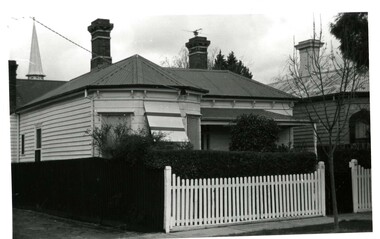
 Eltham District Historical Society Inc
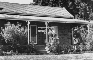
Negative - Photograph, Leader Publishing Co, Wingrove Cottage, c.1970
Wingrove Cottage is historically significant for its long association with Charles Wingrove, a prominent figure in Victorian local government, as secretary to the Eltham District Road Board and Shire Council from 1858 to 1904, and Shire Engineer and Secretary to the Heidelberg Road Board. The cottage was also used as the office of the Eltham District Road Board and Council for many years . One of the Shire's oldest dwellings, and one of the few surviving 19th century buildings associated with early Eltham and located in the original Eltham Village Reserve. Wingrove Cottage is considered historically significant to the Shire of Nillumbik and is registered on the Victorian Heritage Database. This photo forms part of a collection of photographs gathered by the Shire of Eltham for their centenary project book,"Pioneers and Painters: 100 years of the Shire of Eltham" by Alan Marshall (1971). The collection of over 500 images is held in partnership between Eltham District Historical Society and Yarra Plenty Regional Library (Eltham Library) and is now formally known as the 'The Shire of Eltham Pioneers Photograph Collection.' It is significant in being the first community sourced collection representing the places and people of the Shire's first one hundred years.Digital image 4 x 5 inch B&W Neg Print 20 x 25 cmsepp, shire of eltham pioneers photograph collection, eltham, wingrove cottage, charles wingrove, houses -
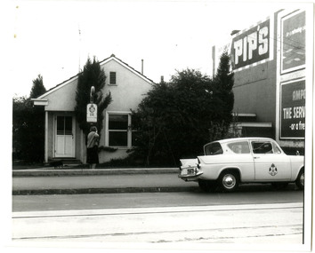
 Eltham District Historical Society Inc
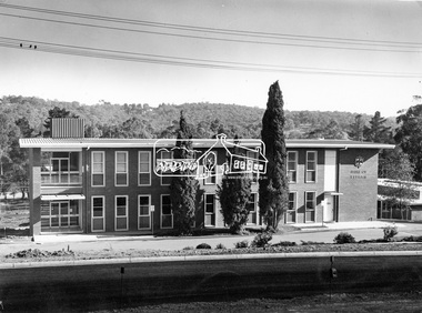
Photograph, Eltham Shire Office, shortly after duplication of Main Road, c.1968
Eltham Shire Council office built 1964 on the former site of Shillinglaw Cottage. In 1971 the offices were extended with a southern wing (to the left of the building) which housed the Eltham Library and planning offices. Taken shortly after widening of Main Road between Pitt Street and Elsa Court which was undertaken between February 1968 and August 1968. Image was most probably commissioned by Eltham Shire Council and taken by Hugh Fisher, photographer who operated from premises between Arthur and Dudely streets and was often contracted by the shire for official photographic work. The image was used in the August 1971 issue of Australian Municipal Journal This photo forms part of a collection of photographs gathered by the Shire of Eltham for their centenary project book,"Pioneers and Painters: 100 years of the Shire of Eltham" by Alan Marshall (1971). The collection of over 500 images is held in partnership between Eltham District Historical Society and Yarra Plenty Regional Library (Eltham Library) and is now formally known as the 'Shire of Eltham Pioneers Photograph Collection'. It is significant in being the first community sourced collection representing the places and people of the Shire's first one hundred years.Digital image and 120 format B&W negativesepp, shire of eltham pioneers photograph collection, eltham, main road, duplication, road widening, shillinglaw trees, local government -
 Eltham District Historical Society Inc
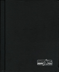
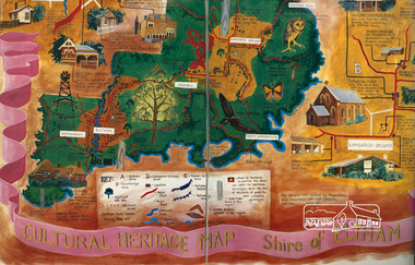
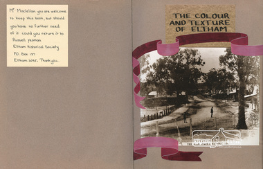
Scrapbook Album, The Colour and Texture of Eltham, 1997, 1997
Put together by a member of the Eltham Gateway Action Group (EGAG) in participation with various artists, writers, local business people and other local citizens and sent to Minister Maclellan, Planning Minister in the Kennet Government in protest of proposed plans to sell the former Eltham Shire Office site at 895 Main Road Eltham in order to develop a Shell Service Station and Hungry Jacks fast food outlet. The purpose was to express what is unique about the character of Eltham, why people live and work there and why such a development would be out of character and inappropriate for the Eltham Gateway along with alternative development proposals. This protest was the catalyst for the formation of the Eltham Gateway Action Group, which later evolved into the Eltham Community Action Group (ECAG).Scrapbook album approx 40 x 30 x 4 cm, black hardcovers and 36 double page openings, numerous blank pages.alan marshall, alistair knox park, alistair knox, alternative proposals, ampitheatre, artists, betty langley, bohdan kucyk, bootmakers cottage, bridge street, cultural heritage map, david armfield, diamond creek, diamnond valley news, eltham art house theatres, eltham community action group, ecag, eltham gateway action group, egag, eltham library, eltham traders, eltham, flavour of eltham, george stebbing, gordon ford, hamish knox, helen lucas, hungry jacks, janet r boddy, jarrold cottage, jarrold family, john pizzey, jon weaving, lena skipper, letters, local business register, 895 main road, main road, eltham shire office, matcham skipper, ming mackay, minister maclellan, montsalvat, mudbrick, newspaper clippings, peter dougherty, peter glass, pioneers and painters, railway line, shell service station, shelltham, protests, shillinglaw cottage, shire of eltham, nillumbik shire, st margaret's anglican church, todaro, trestle bridge, wingrove cottage, charles symons wingrove -
 Eltham District Historical Society Inc
Scrapbook Album, The Colour and Texture of Eltham, 1997, 1997
Put together by a member of the Eltham Community Action Group in participation with various artists, writers, local business people and other local citizens and sent to Minister Maclellan, Planning Minister in the Kennet Government in protest of proposed plans to sell the former Eltham Shire Office site at 895 Main Road Eltham in order to develop a Shell Service Station and Hungry Jacks fast food outlet. The purpose was to express what is unique about the character of Eltham, why people live and work there and why such a development would be out of character and inappropriate for the Eltham Gateway along with alternative development proposals. This protest was the catalyst for the formation of the Eltham Community Action Group.Scrapbook album approx 40 x 30 x 4 cm, black hardcovers and 36 double page openings, numerous blank pages.alan marshall, alistair knox park, alistair knox, alternative proposals, ampitheatre, artists, betty langley, bohdan kucyk, bootmakers cottage, bridge street, cultural heritage map, david armfield, diamond creek, diamnond valley news, eltham art house theatres, eltham community action group, eltham library, eltham traders, eltham, flavour of eltham, george stebbing, gordon ford, hamish knox, helen lucas, hungry jacks, janet r boddy, jarrold cottage, jarrold family, john pizzey, jon weaving, lena skipper, letters, local business register, 895 main road, main road, eltham shire office, matcham skipper, ming mackay, minister maclellan, montsalvat, mudbrick, newspaper clippings, peter dougherty, peter glass, pioneers and painters, railway line, shell service station, shelltham, protests, shillinglaw cottage, shire of eltham, nillumbik shire, st margaret's anglican church, todaro, trestle bridge, wingrove cottage, charles symons wingrove -
 Eltham District Historical Society Inc
Scrapbook Album, The Colour and Texture of Eltham, 1997, 1997
Put together by a member of the Eltham Community Action Group in participation with various artists, writers, local business people and other local citizens and sent to Minister Maclellan, Planning Minister in the Kennet Government in protest of proposed plans to sell the former Eltham Shire Office site at 895 Main Road Eltham in order to develop a Shell Service Station and Hungry Jacks fast food outlet. The purpose was to express what is unique about the character of Eltham, why people live and work there and why such a development would be out of character and inappropriate for the Eltham Gateway along with alternative development proposals. This protest was the catalyst for the formation of the Eltham Community Action Group.Scrapbook album approx 40 x 30 x 4 cm, black hardcovers and 36 double page openings, numerous blank pages.alan marshall, alistair knox park, alistair knox, alternative proposals, ampitheatre, artists, betty langley, bohdan kucyk, bootmakers cottage, bridge street, cultural heritage map, david armfield, diamond creek, diamnond valley news, eltham art house theatres, eltham community action group, eltham library, eltham traders, eltham, flavour of eltham, george stebbing, gordon ford, hamish knox, helen lucas, hungry jacks, janet r boddy, jarrold cottage, jarrold family, john pizzey, jon weaving, lena skipper, letters, local business register, 895 main road, main road, eltham shire office, matcham skipper, ming mackay, minister maclellan, montsalvat, mudbrick, newspaper clippings, peter dougherty, peter glass, pioneers and painters, railway line, shell service station, shelltham, protests, shillinglaw cottage, shire of eltham, nillumbik shire, st margaret's anglican church, todaro, trestle bridge, wingrove cottage, charles symons wingrove