Showing 1266 items matching "james early"
-
 Kew Historical Society Inc
Photograph - John Duncan Brownlee and friends, Yarra River, The Artorium, 1920s
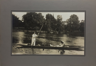
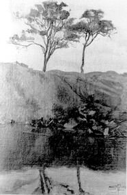
This mounted and framed photograph of a group of friends punting on the River Yarra has a number of historic and artistic associations. The photograph is primarily important as an informal photograph of the Australian baritone John Donald Mackenzie Brownlee (1900-1969), whose international career at the world's major opera houses from 1927 until his retirement in 1958 included singing at Melba's Covent Garden farewell in 1926, to recordings in the 1930s of a major series of Mozart operas in Glyndebourne Festival productions, conducted by Fritz Busch. Brownlee, born in Geelong, won the gold medal as champion vocalist at the South Street competitions in Ballarat in 1921. Moving to Paris in 1923 he began study with the French baritone, Dinh Gilly, making his operatic debut at the Trianon Lyrique in Montmartre in 1926. The most significant periods of his operatic career were with the Paris Opera from 1927 to 1936, and at the Metropolitan Opera from 1937 to 1957. After his move to Paris in 1923, he is recorded as revisiting Australia in 1928 as a member of the Melba-Williamson Company, and 24 years later in 1952. The photograph of Brownlee and the Gardners in a punt on the Yarra, while putatively dated to 1925, must be from earlier in the 1920s before his move to Paris, or later during the Melba-Williamson Company season. Before his move to Paris in 1923, Brownlee had lived in Belmont Avenue, Kew, where he must have developed a friendship with the Gardners. The photograph has additional artistic significance as it was produced at 'The Artorium', James Beament's design studio next to the Hawthorn Town Hall at 362 Burwood Road. With a home at 33 Uvadale Road (designed by Eric Nicholls, who managed the architectural practice of Walter Burley and Marion Mahony Grifffin from 1924 to 1932), Beament painted a number of significant murals for the Griffin practice, including those at the Capitol Theatre in Melbourne.A photograph of recreational activities on the River Yarra. The photograph is historically significant as a professionally produced photograph of the Australian operatic baritone John Brownlee, either before his move to Paris in 1923, or in 1928 during the Melba-Williamson Company operatic tour of Australia. The photograph has additional aesthetic significance as it was produced in James Beament's Hawthorn Studio - The Artorium - at 362 Burwood Road, next to the Hawthorn Town Hall.Framed photograph of John Duncan Brownlee, the Australian tenor, with Enid Gardner and friend in a punt on the Yarra River. Brownlee was born in Geelong but before his move to Paris in 1923, he lived for a period in Belmont Avenue, Kew. Three labels on reverse. 1. "John Duncan Brownlee, Operatic Star, originally of Geelong later resident of Kew at Belmont Av, on the pole. Also in the punt - Edith Gardner a friend. The Gardners lived on the east corner of Edgevale Rd. & Cotham. Approx. 1925." 2. "This picture is the property of Kew Historical Society 1/4/79". 3. Tel. Hawthorn 842 THE ARTORIUM ...."john brownlee (tenor), punting, recreation - yarra river (kew), james beament, the artorium -- 362 burwood road -- hawthorn (vic.) -
 Kew Historical Society Inc
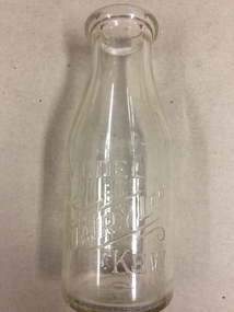
Container, FG Pickering, Milk Bottle, Twentieth Century
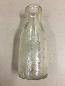
Pickering's Dairy was located on the south Side of High Street, Kew, between Charles Street and Highbury Grove. Kew was a major milk producing district in the Nineteenth and early Twentieth centuries, with three major dairy farms lining the Yarra between Studley Park in the west and Burke Road in the east. In addition to these dairy producers, there were also a number of accredited dairy retailers in the suburb. The largest and most enduring of these was the Model Dairy founded by the Kew pioneer James Venn Morgan. Milk bottles that include the name of the producer or retailer are historically significant as they represent a period in Kew's history before the mass production of milk in the second half of the Twentieth Century. A number of these named bottles have the additional attribute of rarity.Milk bottle - F.G. Pickering, Highbury Dairy, 344 High St., Kew. Pressed inscription: "This bottle contains MILK Bottled for Sale by F.G. Pickering, Highbury Dairy HAW5538, 344 High St., Kew. Bottle is the property of the above. It is loaned and cannot legally be used by others". Reverse: "One Imperial Pint". milk bottles, pickering's dairy (kew) -
 Kew Historical Society Inc
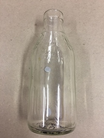
Container, White's Dairy, Milk Bottle, Twentieth Century
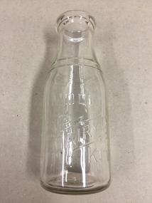
White's dairy was at 52 Willsmere Road, near the Peel Street Intersection. Descendant known locally as Miss White lived at 33 Willsmere Road. This is across the road from the dairy location. Kew was a major milk producing district in the Nineteenth and early Twentieth centuries, with three major dairy farms lining the Yarra between Studley Park in the west and Burke Road in the east. In addition to these dairy producers, there were also a number of accredited dairy retailers in the suburb. The largest and most enduring of these was the Model Dairy founded by the Kew pioneer James Venn Morgan. Milk bottles that include the name of the producer or retailer are historically significant as they represent a period in Kew's history before the mass production of milk in the second half of the Twentieth Century. A number of these named bottles have the additional attribute of rarity.Glass milk bottle from White's Dairy, North Kew. Pressed inscription: "This bottle contains milk bottled for sale by White's Dairy, North Kew, Phone HAW.2154. Bottle is the property of the above. It is loaned and cannot legally be used by others". Reverse: "One Imperial Pint". milk bottles, white's dairy (kew), north kew, willsmere road -
 Kew Historical Society Inc
Container, Model Dairy, Milk Bottle, Twentieth Century
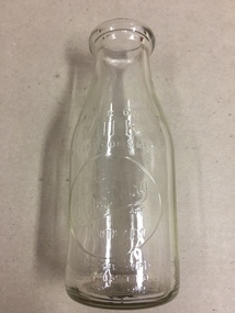
The Model Dairy was founded by the Kew pioneer, James Venn Morgan. The dairy had a number of different locations in Kew depending on the time period. Its final incarnation was on the north side of Cotham Road, between Ridgeway Avenue and Kent Street, Kew. The final factory was designed by the architects Bates, Smart and McCutcheon.Kew was a major milk producing district in the Nineteenth and early Twentieth centuries, with three major dairy farms lining the Yarra between Studley Park in the west and Burke Road in the east. In addition to these dairy producers, there were also a number of accredited dairy retailers in the suburb. The largest and most enduring of these was the Model Dairy founded by the Kew pioneer James Venn Morgan. Milk bottles that include the name of the producer or retailer are historically significant as they represent a period in Kew's history before the mass production of milk in the second half of the Twentieth Century. A number of these named bottles have the additional attribute of rarity.Milk bottle - Model Dairy Kew. Pressed inscription: "Model Dairy Ltd Kew." Reverse: " This bottle contains milk bottled for sale by Model Dairey Ltd and always remains their property. It is loaned & cannot legally be used by others. One Imperial Pint. This bottle differs from 1981.0010 in that it has two pressed rings on the neck of the bottle.milk bottles, model dairy (kew) -
 Kew Historical Society Inc
Container, Model Dairy, Milk Bottle, Twentieth Century
The Model Dairy was founded by the Kew pioneer, James Venn Morgan. The dairy had a number of different locations in Kew depending on the time period. Its final location was on the north side of Cotham Road, Kew between Ridgeway Avenue and Kent Street. Its final factory was designed by the architects Bates, Smart and McCutcheon.Kew was a major milk producing district in the Nineteenth and early Twentieth centuries, with three major dairy farms lining the Yarra between Studley Park in the west and Burke Road in the east. In addition to these dairy producers, there were also a number of accredited dairy retailers in the suburb. The largest and most enduring of these was the Model Dairy founded by the Kew pioneer James Venn Morgan. Milk bottles that include the name of the producer or retailer are historically significant as they represent a period in Kew's history before the mass production of milk in the second half of the Twentieth Century. A number of these named bottles have the additional attribute of rarity.Milk bottle - Model Dairy Kew. Pressed inscription: "Model Dairy Ltd Kew." Reverse: " This bottle contains milk bottled for sale by Model Dairey Ltd and always remains their property. It is loaned & cannot legally be used by others. One Imperial Pint. This bottle differs from 1981.0009 in that it does not have two pressed rings on the neck of the bottle.milk bottles, model dairy (kew) -
 Kew Historical Society Inc
Container, Milk Bottles Recovery Ltd, Milk Bottle, 1930-1950
Milk Bottles Recovery Ltd began production in Melbourne in 1930. Its head office was located at 48 Market Street, Melbourne. It supplied milk bottles to dairies throughout metropolitan Melbourne, and possibly Victoria. It ended production in the 1950s. Smaller Kew dairies without their own named bottles, would have sourced bottles from a statewide provider such as Milk Bottles Recovery Ltd.Kew was a major milk producing district in the Nineteenth and early Twentieth centuries, with three major dairy farms lining the Yarra between Studley Park in the west and Burke Road in the east. In addition to these dairy producers, there were also a number of accredited dairy retailers in the suburb. The largest and most enduring of these was the Model Dairy founded by the Kew pioneer James Venn Morgan. Milk bottles that include the name of the producer or retailer are historically significant as they represent a period in Kew's history before the mass production of milk in the second half of the Twentieth Century. A number of these named bottles have the additional attribute of rarity.Milk bottle - Milk Bottles Recovery Ltd. Pressed inscription: "Milk. One Pint. This bottle belongs to Milk Bottles Recovery Ltd and cannot be used with out written permission. milk bottles, milk bottles recovery ltd -
 Kew Historical Society Inc
Photograph, Floods in North Kew, 1971
Living with natural processes was frequently a challenge to early European settlers and later residents of what was in the 1850s administered by the Borondara Road Board. This was compounded by the area being bounded on three sides by rivers (Yarra River, Koonung Creek and Gardiner's Creek). In 1849, the historian James Bonwick recorded that "our district [Kew] suffered considerably. Mr Wade speaks of 80 acres, out of 100 acres of his cultivated paddock, covered by water." Newspapers continued to describe major flooding in Kew in 1863, 1869, 1878, 1880, 1889, 1891, 1916 and 1934. While the construction of the Upper Yarra dam in 1957 reduced the levels of flowing downstream, local and riverine floods continue.The Kew Historical Society's pictures and map collections testify to the impact of flooding in the district. They have historical importance in documenting the extent of flooding in the district and its affects on homes, services and recreation. Numerous photographs record flooding throughout the Twentieth Century.Floods in North Kew, 1971. Looking northeast towards Kilby Road from River Avenue. Annotation on reverse: map and date "8 Nov. 71 10.30am".floods (kew), yarra river, kew flood, kilby road flood -
 Kew Historical Society Inc
Photograph, Floods in North Kew, 1934
Living with natural processes was frequently a challenge to early European settlers and later residents of what was in the 1850s administered by the Borondara Road Board. This was compounded by the area being bounded on three sides by rivers (Yarra River, Koonung Creek and Gardiner's Creek). In 1849, the historian James Bonwick recorded that "our district [Kew] suffered considerably. Mr Wade speaks of 80 acres, out of 100 acres of his cultivated paddock, covered by water." Newspapers continued to describe major flooding in Kew in 1863, 1869, 1878, 1880, 1889, 1891, 1916 and 1934. While the construction of the Upper Yarra dam in 1957 reduced the levels of flowing downstream, local and riverine floods continue.The Kew Historical Society's pictures and map collections testify to the impact of flooding in the district. They have historical importance in documenting the extent of flooding in the district and its affects on homes, services and recreation. Numerous photographs record flooding throughout the Twentieth Century.Floods in North Kew, 1934. Vicinity of Willsmere Park.floods (kew) -
![Flooding at Chipperfield's Boathouse [East Kew], 1934](/media/collectors/550653872162f11fb04854aa/items/58cbaad5d0cec425b474bfb1/item-media/58cf6fbdd0cf9f331490feb0/item-fit-380x285.jpg) Kew Historical Society Inc
Kew Historical Society IncPhotograph, Flooding at Chipperfield's Boathouse, 1934
Living with natural processes was frequently a challenge to early European settlers and later residents of what was in the 1850s administered by the Borondara Road Board. This was compounded by the area being bounded on three sides by rivers (Yarra River, Koonung Creek and Gardiner's Creek). In 1849, the historian James Bonwick recorded that "our district [Kew] suffered considerably. Mr Wade speaks of 80 acres, out of 100 acres of his cultivated paddock, covered by water." Newspapers continued to describe major flooding in Kew in 1863, 1869, 1878, 1880, 1889, 1891, 1916 and 1934. While the construction of the Upper Yarra dam in 1957 reduced the levels of flowing downstream, local and riverine floods continue.The Kew Historical Society's pictures and map collections testify to the impact of flooding in the district. They have historical importance in documenting the extent of flooding in the district and its affects on homes, services and recreation. Numerous photographs record flooding throughout the Twentieth Century.Floods in North Kew, 1934. Chipperfield's Boathouse and the adding Moorings was located beside the Yarra River near the corner of Willsmere and Kilby Roads. The flood reached the roof of the Moorings, which can be seen in the photo.floods (kew), floods (kew) 1934, yarra river -
 Kew Historical Society Inc
Photograph, Floods in North Kew, 1934
Living with natural processes was frequently a challenge to early European settlers and later residents of what was in the 1850s administered by the Borondara Road Board. This was compounded by the area being bounded on three sides by rivers (Yarra River, Koonung Creek and Gardiner's Creek). In 1849, the historian James Bonwick recorded that "our district [Kew] suffered considerably. Mr Wade speaks of 80 acres, out of 100 acres of his cultivated paddock, covered by water." Newspapers continued to describe major flooding in Kew in 1863, 1869, 1878, 1880, 1889, 1891, 1916 and 1934. While the construction of the Upper Yarra dam in 1957 reduced the levels of flowing downstream, local and riverine floods continue.The Kew Historical Society's pictures and map collections testify to the impact of flooding in the district. They have historical importance in documenting the extent of flooding in the district and its affects on homes, services and recreation. Numerous photographs record flooding throughout the Twentieth Century.Floods in North Kew, 1934. Unidentified location on the Yarra Flood Plain at Kew.floods (kew) 1934, yarra river -
 Kew Historical Society Inc
Photograph, Floods in North Kew, 1934
Living with natural processes was frequently a challenge to early European settlers and later residents of what was in the 1850s administered by the Borondara Road Board. This was compounded by the area being bounded on three sides by rivers (Yarra River, Koonung Creek and Gardiner's Creek). In 1849, the historian James Bonwick recorded that "our district [Kew] suffered considerably. Mr Wade speaks of 80 acres, out of 100 acres of his cultivated paddock, covered by water." Newspapers continued to describe major flooding in Kew in 1863, 1869, 1878, 1880, 1889, 1891, 1916 and 1934. While the construction of the Upper Yarra dam in 1957 reduced the levels of flowing downstream, local and riverine floods continue.The Kew Historical Society's pictures and map collections testify to the impact of flooding in the district. They have historical importance in documenting the extent of flooding in the district and its affects on homes, services and recreation. Numerous photographs record flooding throughout the Twentieth Century.Floods in North Kew, 1934. Chipperfield's Boat House under flood.floods (kew) 1934, yarra river, chipperfield's boat house -
 Kew Historical Society Inc
Photograph, Floods in North Kew, 1934
Living with natural processes was frequently a challenge to early European settlers and later residents of what was in the 1850s administered by the Borondara Road Board. This was compounded by the area being bounded on three sides by rivers (Yarra River, Koonung Creek and Gardiner's Creek). In 1849, the historian James Bonwick recorded that "our district [Kew] suffered considerably. Mr Wade speaks of 80 acres, out of 100 acres of his cultivated paddock, covered by water." Newspapers continued to describe major flooding in Kew in 1863, 1869, 1878, 1880, 1889, 1891, 1916 and 1934. While the construction of the Upper Yarra dam in 1957 reduced the levels of flowing downstream, local and riverine floods continue.The Kew Historical Society's pictures and map collections testify to the impact of flooding in the district. They have historical importance in documenting the extent of flooding in the district and its affects on homes, services and recreation. Numerous photographs record flooding throughout the Twentieth Century.Floods in North Kew, 1934. Flood near the lagoon (Billabong?)floods (kew) 1934, yarra river -
 Kew Historical Society Inc
Photograph, Chipperfield's Boat House & Floating Pontoon, 1934
Living with natural processes was frequently a challenge to early European settlers and later residents of what was in the 1850s administered by the Borondara Road Board. This was compounded by the area being bounded on three sides by rivers (Yarra River, Koonung Creek and Gardiner's Creek). In 1849, the historian James Bonwick recorded that "our district [Kew] suffered considerably. Mr Wade speaks of 80 acres, out of 100 acres of his cultivated paddock, covered by water." Newspapers continued to describe major flooding in Kew in 1863, 1869, 1878, 1880, 1889, 1891, 1916 and 1934. While the construction of the Upper Yarra dam in 1957 reduced the levels of flowing downstream, local and riverine floods continue. A number of boat houses operated on both sides of the River Yarra at Kew. Chipperfield's Boat House was located on the Yarra near the corner of Kilby and Willsmere Roads.The Kew Historical Society's pictures and map collections testify to the impact of flooding in the district. They have historical importance in documenting the extent of flooding in the district and its affects on homes, services and recreation. Numerous photographs record flooding throughout the Twentieth Century.Floating pontoon at Chipperfield's Boat House where the canoes were stored, taken in 1934, presumably before the 1934 Flood. This area of the Yarra was shallow with a number of mid river sandbanks and a popular swimming area for locals.yarra river, chipperfield's boathouse, pontoon -
 Surrey Hills Historical Society Collection
Book, Early history of Canterbury and District, c 1900-1930s
A collection of stories about early Canterbury and Balwyn (Boroondara) compiled by Crosbie Morrison.A collection of stories about early Canterbury and Balwyn (Boroondara) compiled by Crosbie Morrison.Title page: top of page; "1Please return to/Jocelyn Hall/for Alec Martin" in Jocelyn's writing in lead pencil butchers, boot makers, railways, empire day, festivals and celebrations, pong quong, outer circle railway, cycle shop, crosbie morrison, natale b cerini, george robinson, walter gathercole, mr armstrong, alice camm, ethel pascoe, david staig, mr wahanel, mr cook, will tanners, james snedden, john morris, j w terry, j d mclean, j w lowe, c r swan, cr a d renton, a n hendy, t r b morton, morton & coghill, jack kenneally, albert nelson, j rasmussan, tom keating -
 Surrey Hills Historical Society Collection
Book, On these pleasant slope's: a story of Surrey Hills, 2015
Sourced via conversations with those interested in Surrey Hills History. Including Alan Holt, Jack McLean, Frank Bamford, Jocelyn Hall. Includes: Topographical maps, first Elgar Survey. First Wesleyan Church in Surrey Hills. Bibliography on P.50 (last numbered page) Provides a chronological history of Surrey Hills. Includes: First settlers, location, early land sales, commerce and trade.Provides a chronological history of Surrey Hills. Includes: First settlers, location, early land sales, commerce and trade.Back of Title page: To the Surrey Hills Historical / Arthur E. Tonkinfreehold investment and banking company, windsor park estate, (mr) dennis delany, mont albert village, surrey hills - history, royal hotel, surrey hills, humberstone's hotel, chatham state school, holy trinity church, lydswood, lugano, (mr) john butler maling, (mr) john hanlon knipe, mont albert primary school, (mr) james sneddon, (mr) arthur tonkin -
 Surrey Hills Historical Society Collection
Photograph, 111-113 Union Road intersection with Windsor Crescent, 1985
There are earlier photos of this building both in this collection and one on the SLV website. James Sneddon's real estate business was an earlier occupant. Doubleday's occupied the site for nearly 3 decades. Later uses were as a kitchen showroom and a cafe.Colour photo taken on a wet winter's day showing Doubleday Real Estate Agents on the north eastern corner of the intersection. The opposite corner of Windsor Crescent is not visible. Rear in blue biro: "Union Road - Windsor Crescent". Handwriting not recognised. -
 Surrey Hills Historical Society Collection
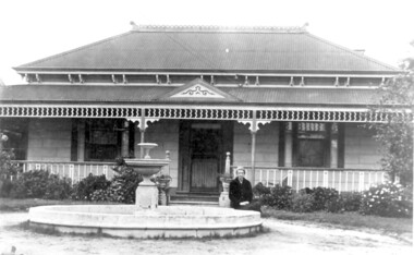
Photo, 'Spenceycroft', Canterbury Road
The photo is of ‘Spenceycroft’ at 654 Canterbury Road, Surrey Hills. For many years this home was hidden behind a large fence sheltering it from the noise of traffic along Canterbury Road, however it dates back to the very early days of settlement in the Surrey Hills area. Canterbury Road was then known as Delany’s Road. ‘Spenceycroft’ is thought to incorporate part of the original farmhouse built on the site by George Klepper, who planted a vineyard in the area. George’s family was one of a number of German families who settled in Surrey Hills during the later part of the 19th century. Later, the land associated with ‘Spenceycroft’ was worked as a dairy farm by James and Elizabeth Rayment. In recent years 'Spenceycroft' has been sold several times and has become increasingly derelict. Sold again in 2015 when it had become quite derelict, it was demolished and re-developed.A black & white photo of double-fronted Victorian style home with a fountain centre front and low foliage in front of the veranda. A woman is sitting by the fountain. 'spenceycroft', canterbury road, james rayment, elizabeth rayment, george klepper -
 Surrey Hills Historical Society Collection
Photograph, Alice Sedgman with grand-daughter
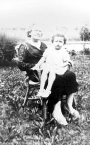
Alice Sedgman (nee Percy) – 1873-1945 Alice was born in Maldon in 1873, one of 9 children of William Henry Percy and his wife Unice King. Alice married Francis Sedgman, occupation painter, in 1896 and they went on to have 8 children, all born in Kew or Hawthorn before the family came to Surrey Hills. The electoral roll for 1903 shows the family living in Liddiard Street in Hawthorn and Alice’s occupation is given as home duties. It is the same in 1909 when they are living at 65 Croydon Road, Surrey Hills and continues to be thus listed in all electoral rolls until the 1943 edition, just before her death. However Mrs Sedgman was also an active nurse and midwife who often worked with Dr James Blakie, who had arrived in Surrey Hills in 1905, initially practicing from 171 Union Road and then in 1913 moving across the road to the purpose-built home and practice at 174 Union Road, now Surrey Hills Medical Centre. At this period most babies were born at home. Sometime after 1931 Alice and Francis Sedgman moved from 65 Croydon Road into 10 Grovedale Road and lived with their son Francis William Sedgman and his family for the remainder of their lives. The photo shows Mrs Alice Sedgman in early 1930s with grand-daughter Joy in the garden of her son. Behind her can be seen the fenced 'quarry' which is now parkland. Alice died in 1945 and Francis in 1951. They are buried in Boroondara Cemetery along with an infant son Clarence and daughter Marjorie. Alice Sedgman was one of the area's early midwives when women for the main part delivered their children at home.A black and white photograph of a lady sitting in a cane chair holding a young girl on her knee.mr francis william sedgman, mr francis sedgman, mrs alice sedgman, miss alice percy, miss joy sedgman, mrs joy scanlon, grovedale road park, grovedale road quarry, croydon road, grovedale road, midwife, nurse -
 Surrey Hills Historical Society Collection
photograph, Dr Una Porter
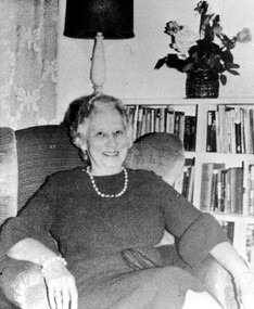
Dr Unice (Una) Beatrice Porter, OBE, CBE (1900 - 1996) Una Porter was the youngest daughter of Frederick John Cato and his wife Fanny (née Bethune). She had 3 sisters and 4 brothers. Her father was of course the prominent businessman and co-founder of the Moran & Cato grocery company who was known for his generosity and commitment to the Methodist Church. Given this background it is not surprising that Una inherited a deep and lasting Christian faith that would become the driving force behind her own career and philanthropic activities. Una was educated at Methodist Ladies College and the English boarding school "Farringtons" however her formal education ended at the age of 14 due to ill health. By the outbreak of the First World War her sisters were married and her brothers enlisted. Una became very close to her father and assisted him in establishing hospitals and missions in Arnhem Land, Fiji and India. Una returned to formal study and matriculated at the age of 30. A niece with diabetes was the catalyst which led Una to study medicine. She enrolled at the University of Melbourne in 1933 and subsequently specialised in psychiatry with training at Prince Henry's Hospital, the Royal Park Mental Hospital and the Children's Hospital. In 1946 she took a post at the Ballarat Mental Hospital. Here she was the first female member of staff, overseeing 512 female patients. She later worked in private practice and was instrumental in the establishment of a psychiatric clinic at the Queen Victoria Hospital. Throughout her life, Una maintained a strong link with the Young Women's Christian Association (YWCA) and in 1963 was elected as the World President of this organisation and in 1964 she was elected Woman of the Year. Una's philanthropic work was extensive. In addition to administering the F.J. Cato Charitable and Benevolent Trust and later the James and Una Porter Trust Fund, she made substantial personal donations to hospitals, universities and community organisations including the University of Melbourne, Monash University, Epworth Hospital, Methodist Ladies College, Cato College, Queen Victoria Hospital and the YWCA. It is estimated that she gave over $1 million to various hospitals and institutions. Some of her projects included establishing a scholarship for rural female students to attend university, a Chair in Psychiatry, and extensive research into early childhood development. Una B. Porter was appointed O.B.E. (1961) and C.B.E. (1968) in recognition of her services to the community. At the age of 46 Una married James Roland Porter, an ex-RAAF squadron leader and a lifelong friend. Until this time, Dr Porter had lived at the Cato family home, ‘Kawarau’ at 192-198 Tooronga Road, Hawthorn (later Stephanie’s restaurant). In spite of having qualified as a doctor and with all her philanthropic activities, at age 43 the electoral rolls give her status as ‘home duties’! Dr Porter’s connection with Surrey Hills came after her marriage. In 1948 she and her husband bought 8 Kent Road. A black and white photograph of a screened image of a lady sitting in a winged-back chair. She is wearing a knee length dress with three-quarter length sleeves, and beads around her neck and wrist.psychiatrist, philanthropist, queen victoria hospital, mont albert, surrey hills, 8 kent road, dr una porter, mr james porter, dr unice beatrice porter, mr frederick cato, miss unice beatrice cato, mrs fanny cato, miss fanny bethune, young women's christian association, fj cato charitable and benevolent trust, james and una porter trust fund, methodist ladies college -
 Surrey Hills Historical Society Collection
Photograph, Muriel Pornitz (deceased), Quarry on site of Grovedale Road - James Street Park
The photo is of a painting of the dam formed on land between Grovedale Road and James Street, Surrey Hills. It was painted in 1927 by Miss Muriel Pornitz, an art teacher, who lived in Grovedale Road. The land had been part of Mr James Maling Snr’s property and in the 1880s clay was removed to build houses, including his own located on the corner of Weybridge and James Streets. Maling grazed cattle on this area and used it as a dam. The land was subsequently made into parkland, the quarry / dam having been filled in after several drownings had occurred in the 1920s/1930s. See also SHP94, another copy of the same. Muriel Hedwig Lucy Pornitz lived at 22 Grovedale Road, Surrey Hills. She was born c1894 in Balwyn; died in Kew on 1 December 1982. She was the daughter of Konrad Pornitz (1864-1903) and his wife Charlotte Richardson Gooderidge (1863-1942), known as Tottie, who married in 1890. Konrad Pornitz is listed in the 1892 directory as living in Edgevale Road, Kew and the business Pornitz and Ross at 291 & 293 Little Collins Street, importers and commission merchants. The 1896 directory gives the Kew address as 176 Edgevale Road, Kew, however the business Pornitz and Ross was dissolved on 1st day of October 1892, by mutual agreement. Legal notice advised that: Mr Pornitz will hereafter carry on the business on his own behalf at the same address, under the style "Pornitz and Ross". Muriel is buried in Box Hill Cemetery (B-086-0042) along with Ulrich Horst Holm Pornitz known as Horst or Bon (d 1957) and Edith Olga Pornitz (d 1951), her brother and sister. A further sibling (Konrad b 1891) died in infancy. He is buried with his mother in Boroondara (Kew) Cemetery - C/E A 0366. Konrad died at his home 'Yarran' in Lane Cove Road, North Sydney on 31 October 1903; reported in the Sydney Morning Herald. Buried Gore Hill Cemetery, St Leonards, North Sydney. The headstone reveals he was born in Chemnitz, Saxony in 1863. Muriel was also known as Muriel Pornett. She studied at the South Australian School of Arts & Crafts in 1911 under James Ashton and Fred Britton, and at the Australian School of Etching in Sydney. She was also an illustrator and cartoonist. The photo, and the painting from which it is derived, documents the landscape prior to close settlement and is material to early building and farming in the Surrey Hills area.A black and white photograph of a painting of a landscape of parkland. Two trees are on top of a rise and are reflected at the bottom in water. The signature of the artist is in the bottom right corner: "AUST MP 192" (and the rest is cut off).(miss) muriel pornitz, grovedale road, james street, surrey hills, artists, parks and reserves, (mr) john butler maling, snr, quarry, dam, (miss) muriel hedwig lucy pornitz, box hill cemetery, muriel pornett -
 Surrey Hills Historical Society Collection
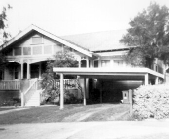
Photograph, "Braemar" 18 Suffolk Road, Surrey Hills
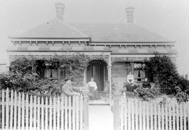
"Braemar" at 18 Suffolk Road, Surrey Hills - built c1894, demolished in1977 – and home of James Sneddon Snr. and family from 1890 until c1950. We believe it is James is at the gate and his family on the veranda. James was born in Alloa, Clackmannanshire Scotland in 1833, as was his wife Jane. He died in March 1901 and she in March 1911. They are buried in Boroondara Cemetery (Pres B0522) with their daughter Jane (1864-1928). James Sneddon (Snr) was an important man in early Surrey Hills. He established real estate and ironmongery businesses in Union Road – first on the corner of Stirling Crescent and later over the road on the corner of Windsor Crescent. He was chairman of Surrey Hills’ MUIOOF (Manchester Unity Independent Order of Oddfellows). James Sneddon Jnr. followed his father in the family real estate business and was an even busier community man. He was a JP and had roles in the Surrey Hills ANA, the Progress Association and the Choral Society. He lived 2 doors from his father. The real estate business continued on the corner of Windsor Crescent and Union Road (north side) until the business was sold to the Doubleday (family) after WW2.The Sneddon family were early settlers and business owners in Surrey Hills and remained over 3 generations. Different family members held many roles in community organisations. This photo is also important in documenting built heritage that has been demolished.Image of a Victorian, weatherboard, block fronted, single storey house with decorative veranda, viewed from the front. The garden in front of the house is well established and a light-coloured picket fence surrounds the property. Four people are in the photograph, three women (two seated and one standing) on the veranda and one male, who is leaning against the gate post.buildings, structures and establishments, houses, timber houses, house names, braemar, architectural styles, victorian style, families, family group, sneddon family, james sneddon (snr), boroondara cemetery, real estate agent, ironmonger -
 Surrey Hills Historical Society Collection
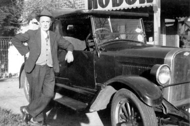
Photograph, Frank Etheridge, outside the small general store at 224 Mont Albert Road, Surrey Hills
In earlier years (c1923-1943), the shop was known as Mrs Sim's shop. Note that prior to c1928 the property was numbered 292 Mont Albert Road. Electoral rolls describe Victoria May Sims (nee Munday) as a confectioner but she also sold school requisites and other general household items. Her husband Harry Pascoe Sims died in 1926. The shop was taken over by Leonard William James Etheridge, whom electoral rolls and probate records variously describe as a grocer, stationer or builder. His sons Austin, Douglas and Leonard attended nearby Chatham Primary School. Leonard senior and his wife Marie Wanda (nee Chambers) lived in various locations around Surrey Hills after leaving the shop. Austin went on to establish Etheridge Ford in Ringwood.A black and white photograph of a man dressed in a suit wearing a hat. He is standing beside a car parked beside a shop.mrs sims shop, mont albert road, surrey hills, chatham school, austin etheridge, frank etheridge, victoria may sims, leonard william etheridge, douglas etheridge, leonard etheridege, marie wanda etheridge, marie wanda chambers -
 Surrey Hills Historical Society Collection
Photograph, Grovedale Road Quarry in the 1920s - looking south, c1920
The quarry was part of John Butler Maling's property. He was one of the original settlers of the area and farmed the area between Weybridge Street and Whitehorse Road. Clay was quarried from part of this area and used to make the bricks used in the construction of his home, known as 'Ancyra'. This is still extant at the corner of Weybridge and James Streets. Maling grazed cows and used the quarry as a water source. He was the uncle of John Butler Maling, Mayor of Camberwell. He was married to Kate Conlon in 1882. They had 3 children: Silas Young, Alick and Zillah. Maling was born in c1829 in Shepreth, Cambridgeshire; he died in Surrey Hills on 9 October 1912 and is buried in Box Hill Cemetery - CE-*-0586. Mrs Kate Maling (born c1859 in Co Meath, Ireland) died at the property on 8 March 1921. She is buried in Brighton General Cemetery. Probate was valued at over 10,000 pounds and included other properties in Sandringham, Hawthorn and Macedon. At the time of her death the Surrey Hills property was described as being 23 acres with 2 brick houses, 1 cow, 2 heifers and 40 fowls or chickens. The property was subdivided after her death. The property was subdivided into 110 house blocks in c1923 - see Maling's Estate subdivision flyer on the State Library of Victoria's website. This shows that the Grovedale Park site had been acquired by Camberwell Council by this time. An attached newspaper clipping documents prices realised for a cross-section of blocks. The MMBW map of 1925, also on the SLV website, shows the outline of the clayhole / quarry. The quarry was filled in after several drownings or near drownings and the land is now occupied by a park and playground, known as Grovedale Road Park, maintained by the City of Boroondara. Beckett Park is sited on horizon to the left beyond the trees. This documents the landscape prior to close settlement and is material to early building and farming in the Surrey Hills area.Black and white photo of the quarry between Grovedale Road and James Street taken in the 1920s and looking south. In the foreground is an area of water with reeds in the LH corner. Beyond on the high banks there are single storey houses in the background and (?) some light poles. An object that looks like a tank on posts is in a cutting on the far bank.quarries, grovedale road, james street, clay quarries, farming, kate conlon, kate maling, john butler maling, ancyra -
 Surrey Hills Historical Society Collection
Photograph, Grovedale Road Quarry in the 1920s - looking north, c1920
The quarry was part of John Butler Maling's property. He was one of the original settlers of the area and farmed the area between Weybridge Street and Whitehorse Road. Clay was quarried from part of this area and used to make the bricks used in the construction of his home, known as 'Ancyra'. This is still extant at the corner of Weybridge and James Streets. Maling grazed cows and used the quarry as a water source. He was the uncle of John Butler Maling, Mayor of Camberwell. He was married to Kate Conlon in 1882. They had 3 children: Silas Young, Alick and Zillah. Maling was born in c1829 in Shepreth, Cambridgeshire; he died in Surrey Hills on 9 October 1912 and is buried in Box Hill Cemetery - CE-*-0586. Mrs Kate Maling (born c1859 in Co Meath, Ireland) died at the property on 8 March 1921. She is buried in Brighton General Cemetery. Probate was valued at over 10,000 pounds and included other properties in Sandringham, Hawthorn and Macedon. At the time of her death the Surrey Hills property was described as being 23 cres with 2 brick houses, 1 cow, 2 heifers and 40 fowls or chickens. The property was subdivided after her death. The quarry was filled in after several drownings or near drownings and the land is now occupied by a park and playground maintained by the City of Boroondara. Beckett Park is sited on horizon to the left beyond the trees. This documents the landscape prior to close settlement and is material to early building and farming in the Surrey Hills area.Black and white photo of the quarry between Grovedale Road and James Street taken in the 1920s and looking north. In the foreground is an area of water with high banks dividing the horizontal centre. Beyond are paddocks and trees behind which is a row of at least 3 single-storey houses. Light poles can be seen along a distant street. There are many mature trees in the background. The houses and trees are positioned along Whitehorse Road in the vicinity of Westminster Street. Shadows indicate the photo was taken in early morning or evening.quarries, grovedale road, james street, surrey hills, balwyn, clay quarries, ancyra, kate conlon, kate maling, john butler maling, farming -
 Surrey Hills Historical Society Collection
Photograph, Home and surgery of Dr William Langley Carrington, 174 Union Road, 1935
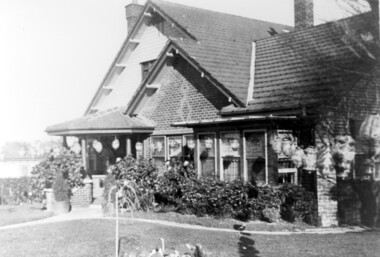
The building was erected in c 1913 as a home / surgery for Dr James L Blakie (1868-1937), who originally lived / practised across the road. It was designed by architect Arthur William Plaisted (1890-1965) and is an early example of attic-style Californian bungalow style. Dr Carrington ( 1900-1970) succeeded Dr Blakie and practised at 174 Union Road from 1930-1970. Now known as the Surrey Hills Medical Centre.Black and white photo of the surgery and home of Dr and Mrs William Langley Carrington at 174 Union Road on the corner of Guildford Road, Surrey Hills.. The exterior of the building is decorated with paper lanterns around the windows and veranda for the Empire Day celebrations in 1935. The building is 2 storey, of brick construction with a tiled roof and front porch. It has a bay window front right. Shadows indicate the photo was taken early morning in winter.medical services, guildford road, union road, dr william langley carrington, mr arthur plaisted, dr james landells blakie, californian bungalow, dr bill carrington -
 Surrey Hills Historical Society Collection
Photograph, 3 Norfolk Road Surrey Hills - home of Mr and Mrs Albert Ernest Vine
Albert Ernest Vine Snr, was a City of Camberwell Councillor from 1926-1934 and 1937-1944. He was also Mayor of Camberwell in 1940/41. There is a sundial in the Surrey Gardens erected in his memory. Known as Ernest, he and his wife Edith (nee Sword) lived at 3 Norfolk Road from 1920-1945. Earlier addresses are on file in Alan Holt card index. He was active in Surrey Hills Progress Association. He was the son of William James Vine (1860-1920) and Sarah Elizabeth Gunner (1859-1941). W J Vine & Co Timber Yards were located at 587-593 Canterbury Road. Elizabeth Gunner's brother was Henry Gabez Gunner (1862-1940), a builder in the Surrey Hills area. Box Hill Reporter (6/6/19) records that Ernest applied to Camberwell City Council for permission to subdivide land in Norfolk Road with a frontage of 85' into 2 equal lots for a dwelling to be erected on each, one for himself and the other for his mother. Albert Ernest & Edith Vine had the following children: Albert Ernest Jnr (b 1904), Robert (b 1908), Edgar (b 1912), Inez (b 1915) and Beth (b 1918). Both No 1 & No 3 were demolished c1970.Black and white photo of a 1920s style single-storey weatherbaord home with leadlight windows, a tiled roof and a wide veranda supported by timber columns on stucco pillars. The veranda has a simple timber balastrade and a flight of timber stairs to it. There does not appear to be front fence. A simple sloped double carport on the RHS and proud of the house is of a later date.norfolk road, californian bungalows, w j vine & co timber yards, mr william james vine, mr albert ernest vine, mrs edith vine, miss edith sword -
 Surrey Hills Historical Society Collection
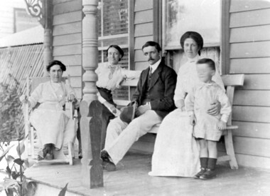
Photograph, Mr and Mrs P Falconer and son, Ron at Aird family home, 1913
It is identified as the home of J B Aird. The 2 women on the left are not identified. On the right are Mr & Mrs P Falconer and son Ron. Mrs Falconer was nee Aird. Research: 1917 electoral roll lists James Bromich Aird (optician), Sarah Ann Aird (HD) and Hilda Lillian Aird (tailoress) at 'Stratford', Croydon Road, Surrey Hills. Earlier electoral roll lists him in Ringwood and later ones at Wandin North. James Bromich Aird (1854-1938) and Sarah Ann Edwards (1858-1930) had 7 children. Emily Victoria Aird (1884-1957) and Hilda Lillian Aird were 2 of their daughters. Emily married Patrick Henry Falconer (1879-1964). Their son Ronald Keith Falconer (1908-1983) was born and died in Surrey Hills. James and Sarah Aird are buried in Box Hill Cemetery. Given the collecting focus adopted by Jocelyn Hall it can be assumed that this was taken at 'Stratford' in Croydon Road, Surrey Hills. Possible identification of the 2 other women in the photo would be Sarah Aird on the left on the deck chair and Hilda Aird on the bench with the Falconer family.Black and white photo of a family group of 3 women, a man and a young boy on the verandah of an Edwardian timber home. edwardian style, clothing and dress, ronald keith falconer, patrick henry falconer, miss emily victoria aird, mrs emily victoria aird, miss hilda lillian aird, james bromich aird, mrs emily victoria falconer, miss sarah ann edwards, mrs sarah ann aird, stratford, croydon road, box hill cemetery -
 Surrey Hills Historical Society Collection
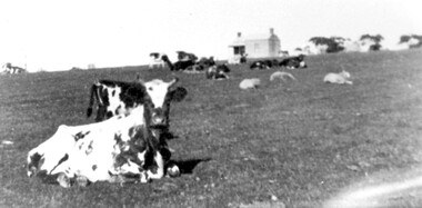
Photograph, Norman Carter, Part of Black's dairy farm in Mont Albert in the 1920s, 1920s
Photo is likely to have been taken pre-1924 when the land was subdivided. Donor information is that this was taken from a home in Churchill Street, Mont Albert; it would be looking south towards Mont Albert Road. Black's dairy farm occupied the area just east of Hamilton Street to near Elgar Road. It was subdivided into 88 house allotments along Churchill Street, Bruce Street, Black Street, Proudfoot Street and View Street. The solicitors were Proudfoot & Horton, 360 Collins Street; estate agents were Duncan & Weller, 29 Queen Street. The real estate subdivision notice on the SLV website states that Neil Black had been the owner for 50 years. To date no trace of a Neil Black has been found. Box Hill rate books simply give BLACK as the owner in 1877 (no first name); the entry for 1878-1884 states Robert Black. The 1909 electoral roll has entries for Mont Albert Road for Robert Black (farmer), Thomas Black (carter) & Elizabeth Black (HD). The 1912 electoral roll has entries for Mont Albert Road for Robert Black (farmer), Thomas Black (labourer), John Arthur Black (carter) & Elizabeth Black (HD). Robert Black died in 1920 (b. 1836) and is buried in Box Hill Cemetery (CE-*-0057). His parents were John and Margaret Black. He married Lizzie Foley in 1878. She was the daughter of Margaret & John Foley, born in 1859. She died in 1902 aged 43 years and is probably buried in the same grave, although the cemetery records record her age as 0 years. Children: 1. James Hughbert (1880-1954) 2. John Arthur (1881-1959) 3. Alice (1882-1883) - died aged 6 months 4. Laura Elizabeth (1883-1951) 5. Thomas (1885-1965) 6. Isabella (1887-1963) 7. Eleanor (1889-1963) 8. Ada Maud (1890-1968) 9. Robert (1892-1930). BDM Victoria states places of birth as Box Hill, Surrey Hills or Mont Albert. Many of the family are buried in Box Hill Cemetery. None of the girls appear to have married. Communication from a descendant of John Arthur Black gives the following: "John Arthur Black, son of Robert & Lizzie Foley, married Gladys Anne Layton had 4 children, Robert, Elenore, Marion (Follett) & Annie; they had farm on Stud Road, Dandenong where they milked 30 cows that he retired to after being a earth-moving contractor with draft horses and dug irrigation ditches around Shepparton." This is important as documentation of the area's early farming land use.Black and white photo of a paddock with cows and sheep grazing. On the horizon is a simple cottage with a small veranda and 2 chimneys and scattered trees.black's dairy farm, dairying, farms, churchill street, black street, proudfoot street, bruce street, view street, neil black, proudfoot & horton, duncan & weller, robert black, lizzie black, lizzie foley, james hubert black, john arthur black, alice black, laura elizabeth black, thomas black, isabella black, eleanor black, ada maud black, robert black jnr, box hill cemetery -
 Surrey Hills Historical Society Collection
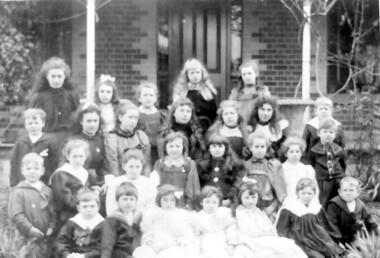
Photograph, Ken Hall (deceased), Campden Ladies College students, Windsor Crescent, Surrey Hills, Copy - c1983
Campden Ladies College was located at 16 Windsor Crescent from 1887-1898 and then at 44 Windsor Crescent from 1899-1901 under the direction of Mrs Philippa James and one of her daughters, also Philippa. Philippa Bridges was born in Pentonville, Middlesex in 1820. She was engaged to John Frederic James before she left England and they were married soon after he arrived in Melbourne in 1853. He was the second registrar at the University of Melbourne (1856-1864) and died suddenly in 1864. The couple had 4 daughters (3 surviving - Mary, Philippa and Elizabeth) and one son, John Frederic Chase James, who lived at 'St Helena', Norfolk Road, Surrey Hills. Their 2nd daughter, Philippa Sophia assisted in the school; she pre-deceased her mother and died at 'Campden' on 18 March 1900. Mrs James' obituary in the Box Hill Reporter on 5 May 1911 states that she opened an earlier school called Grantown House in Nicholson Street, Fitzroy opposite the Exhibition Building after her husband's death. Grantown House is extant and has a National Estate Register Listing. The citation for it states that Mrs Philippa James leased it from owner William Ross and operated a ladies school from here from 1872 until 1878. She had other schools, both before her marriage and one in Balaclava named 'Westbourne'. One of the students (unidentified) in the photo is Edith Dorothy Dunn, who became an early talented photographer.schools, surrey hills, independent schools, education, primary education, dorothy dunn, campden ladies college, (miss) philippa bridges, (mrs) philippa james, edith dorothy dunn, (miss) philippa james -
 Surrey Hills Historical Society Collection
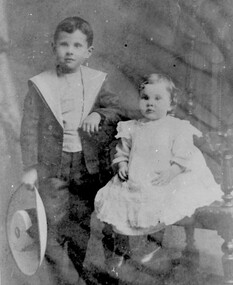
Photograph, John Colin Reaburn with his younger brother, Wallace James Reaburn, c1911
Children in photo identified as John Colin Reaburn, also known as Jack, and his young brother, Wallace James Reaburn. The Reaburn family came to Surrey Hills in the 1890's and first lived in Russell Street. John Colin Reaburn (B 1899 in Russell St, Surrey Hills; D 1987, Box Hill) and Wallace James Reaburn (B 1910; D 1996) were the children of John Reaburn (1873-1963) and his wife Jane (Jeannie) Nelson Harkins (1875-1959). They has a sister Winifred Jean Reaburn (1904-1983). The family later lived in Union Road on the SW corner of Guildford Road. The house was called 'Fairbank'. John completed his education to eighth grade of Surrey Hills State School, going on to University High School and became an accountant. He later moved away from the area but when the collection of local history commenced in the 1970's, John was living near Belmore Road and became involved. He had a clear recall of early days and played a valuable part in recording details of early Surrey Hills.B/W photo (photo dark) of two young children. The boy standing is dressed in long pants and a jacket with a wide collar like a sailor suit. He is carrying a wide brimmed hat. The other child is seated and wearing a lacy coverall over a dress. 5 tabs / residual glueclothing and dress, surrey hills, children, mr john reaburn, mr john colin reaburn, mr wallace james reaburn