Showing 2308 items
matching rail-wycheproof
-
 Lakes Entrance Historical Society
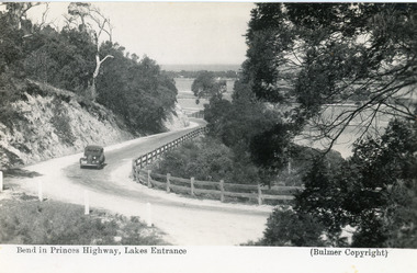
Postcard - Princes Highway Kalimna, Bulmer H D, 1935c
Black and white postcard of the Princes Highway as it winds around Jemmys Point. A motor car driving up the hill between steep road cutting and post and rail fence. View of the lake and ocean in the distance. Lakes Entrance VictoriaBend in Princes Highway, Lakes Entrance fences, roads and streets -
 Ballarat Tramway Museum
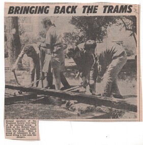
Newspaper, The Courier Ballarat, "Bringing back the trams", Apr. 1973
Newspaper clipping from The Courier, ?/4/1973 of five members of the BTPS lifting a rail onto sleepers along the position of the access track. Features from Left (W. A. Doubleday, ? (behind a person), ?, L. Bounds and J. Bounds)date in pencil of "12?/4/73" in top right hand corner of cutting.trams, tramways, btps, track laying, museum establishment -
 Lakes Entrance Historical Society
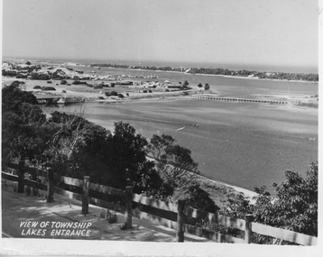
Postcard - North Arm bridge Lakes Entrance Victoria, 1947c
Black and white small format postcard showing town, North Arm bridge, post and rail fence beside the road, bridge to Bullock Island, Cunninghame Arm and sand hummocks, motor boat on the lake. Lakes Entrance VictoriaView of Township Lakes Entrancebridges, township -
 Sunbury Family History and Heritage Society Inc.
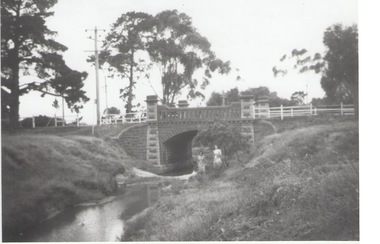
Photograph, Rosa McCall, Moonee Ponds Creek, 1949
The single arched stone bridge spans the Moonee Ponds Creek in the former Old Broadmeadows Township, now Westmeadows. The historic bridge is in Fawkner Street, and has a heritage classification. The Moonee Ponds Creek flows from the upper reaches of Greenvale and flows into the Yarra at Docklands.The stone bridge over the Moonee Ponds Creek was erected in 1869 and replaced a less substantial one.A black and white print of a non-digital photograph of a stone single-span bridge spanning a creek. White post-and-rail fence has been constructed ion either side of the bridge. Pine trees are growing on then creek banks.moonee ponds creek, old broadmeadows township, bridges, fawkner street, westmeadows -
 Bendigo Historical Society Inc.
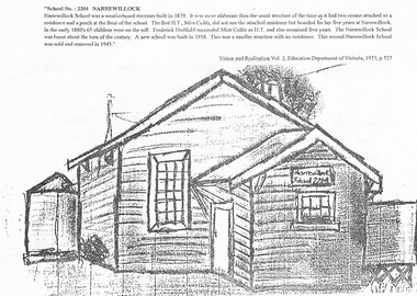
Photograph - NORM GILLIES COLLECTION: INVITATION TO THE LAYING OF A PLAQUE AT OLD NARREWILLOCK STATE SCHOOL
An invitation, received by Mr & Mrs Norman Gillies, to the laying of a plaque at old Narrewillock State School No. 2204 site The invitation reads: The attendees: Mr. & Mrs. Norman Gillies Are cordially invited to the plaque unveiling of the Narrewillock School (No. 2204) The unveiling will take place at the old School siteon the corner of the Glenloth Rd, and the Charlton-Qyambatook Rd on Monday 17th April 1995, at 10.30 am. this will be followed by a cup of tea. R.S.V.P. 11th April 1995 Mr. m. fradd R.M.B. 1006 Wycheproof Vic 3527 (054)92 9221 -
 Orbost & District Historical Society
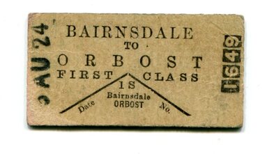
ticket, 5th August 1924
The Bairnsdale-Orbost railway was opened in 1916 to serve the agricultural and timber industry. Because of the decline in traffic and heavy operating costs, the line was finally closed in August, 1987. A rail motor which was used from 1924 – 1935, had the appearance of a motor bus on wheels. In October 1926 the rail motor service introduced from Bairnsdale to Orbost in May 1924 was in danger of being abandoned. The Victorian Railways Commissioners stated that patronage had not been satisfactory despite a one and a half hours reduction in the travel time.This item is associated with the history of the Orbost-Bairnsdale railway line and therefore reflects the role that the rail line played in the social and economic history of Orbost.A small cardboard first class train ticket - buff coloured with black print. It is from Bairnsdale to Orbost.orbost-bairnsdale-railway transport railway -
![Photograph - Digital Image, Gilding portrait [man and woman], 1890c](/media/collectors/4f729f5697f83e03086015b8/items/5455c3632162f10d64f9ba8e/item-media/5455c38c2162f10d64f9bcb3/item-fit-380x285.jpg) Greensborough Historical Society
Greensborough Historical SocietyPhotograph - Digital Image, Gilding portrait [man and woman], 1890c
Portrait of George Iredale and Anna Marie Iredale [nee Gilding]. The Gilding family lived in Greensborough and operated a Bootmaker’s shop located on the west side of Main Street, north of the rail line.Digital copy of black and white studio photograph.gilding, gilding family -
 Hume City Civic Collection
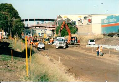
Photograph, 21/04/2005
This photograph was taken during the upgrade of the Bendigo Railway line at Sunbury Station. The upgrade of the rail track took over twelve months to complete and during that time buses replaced the train services.A coloured photograph of construction on the site of the Sunbury Railway Station. The photograph has been taken from the end of the Melbourne platform and shows the various pieces of machinery, which included an excavator, a fork lift and trucks, that were used in the work on the line.railways, bendigo line, railway stations, bridges, sunbury railway station, george evans collection -
 Melbourne Tram Museum
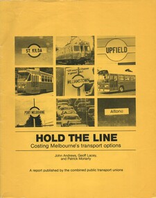
Document - Report, John Andrews, Geoff Lacey, Patrick Moriarty, "Hold the line - Costing Melbourne's transport options", Jun. 1981
Report - or booklet - 40 pages printed on newsprint plus gloss paper cover - quarto size - centre stapled - titled "Hold the line - Costing Melbourne's transport options" Written by John Andrews, Geoff Lacey and Patrick Moriarty - published by the combined public transport unions - June 1981. Looks at the impacts of the Lonie report and Minister Maclellan options for reducing public transport in Melbourne and converting rail lines to light rail, sustainability. Has a table of contents, list of unions involved. See image i5 for a summary of the report - back cover.trams, tramways, lonie report, unions, public transport, melbourne, light rail, upfield light rail, buses -
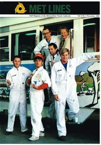 Melbourne Tram Museum
Magazine, Metropolitan Transit Authority (MTA), "Met lines - Vol. 4, No. 2", Nov. 1987
Met lines - Vol. 4, No. 2, November 1987, staff newspaper of the Metropolitan Transit Authority - 20 pages, A4 size when centre stapled, printed on gloss paper. Has tramway related items on: 1 - Mental as anything standing in front of their painted tram - No. 726, along with Brian Carter, Senior Foreman 2 - 130 Light rail vehicles for the Met 3 - Light rail vehicles for Hong Kong 4 - Conductors find the driving seat is just the ticket - Hawthorn driving school 5 - Bundoora tram extension openstrams, tramways, transporting art, decorated trams, the met, mta, hawthorn, driver training, bundoora, hong kong, b class, tram 726 -
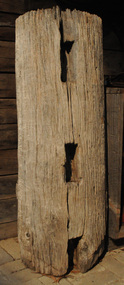 Orbost & District Historical Society
fence post, 1840's
This fence post is from the original Snowy River Station stock yards which were where "Merindah" stands today. It was probably owned by the Marshall family at the time of transfer to "Merindah" in 1985. It was lifted out by Geoff Stevenson with a bucket on a tractor in 1986. The post was originally twice the length. The Snowy River Station was established in 1842 by Peter Imlay. In 1845 the land was sold to Norman MCLeod who named the area Orbost. After financial difficulties in the 1870's the run was taken over by W.J.Clarke and known as Orbost Station.Peter Imlay established the first white settlement in 1842 settling on the eastern side of the Snowy River where the township of Orbost now stands. This settlement was the Snowy River Station. A corner post from a post and rail fence. It is possibly made of red box.. On one side are three rectangular sections cut out with a similar one on the other sides. The post is hollow and has metal staples in the sides for attaching wires.orbost-station mcleod fence-post -
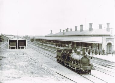 Bendigo Historical Society Inc.
Photograph - WES HARRY COLLECTION: BENDIGO RAILWAY STATION
Black and white photo, copy: image shows Bendigo Railway Station, steam locomotive on rail, no carriages. Buildings constructed of brick, large verandah extending length of platform. Large group of men standing on platform dressed in suits, hats.place, bendigo, bendigo railway station, bendigo, sandhurst, rail, railway station, steam locomotive -
 Bendigo Historical Society Inc.
Book - BLUE GUIDE 1988, 1988
Blue Guide 1988 - booklet of Bendigo information with illustrations and map. Includes emergency contaacts, bus and rail timetables, telephone directory, services listing, Justices of the Peace. Booklet sent 'To the Householder' 56 pages plus loose map of BendigoBlue guide publicationsbendigo, hospital, bendigo, information booklet, blue guide. -
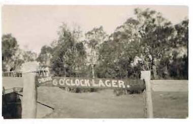 Bendigo Historical Society Inc.
Photograph - COHN BROTHERS COLLECTION: SIGN, ?
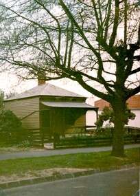
Photograph of the top railing of a wooden fence. On the left hand side rail is painted ' Drink 6 O'clock Lager,. There appears to be a bridge on the extreme left of the photo, a clear grassy area in the foreground with trees in the background. There is also a telephone pole visibleorganization, business, product, cohn brothers . 6 o'clock lager -
Tatura Irrigation & Wartime Camps Museum
Photograph, Williams Cycle Shop
Williams Cycle Shop was in Walsh Street Tatura.Black and white photo of Williams Cycle Shop, Walshe Street, Tatura. Horse rail in front. Two large and one small bikes leaning on front windows. Verandah has iron decoration. In black plastic glassed frame with L1067williams cycle shop, tatura bicycle shop, walsh street tatura, joyce bell -
 Stawell Historical Society Inc
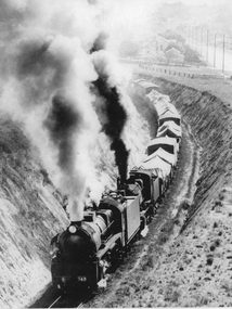
Photograph, R 748 Class Steam Engine pulling freight in cutting
R 748 Class Steam Train Engines pulling freight in cutting. the freight trucks have material coverings. Houses can be see in the background of the photo. The photo was taken approximately in c 1962. Large black & white photo (copy) showing two steam train engine pulling freight trucks, on the railway at Stawell. This rail line is the main line between Melbourne & Adelaide. The first engine is an "R" class 748. c 1951R 748 on Engine and 1962 hand written on the back.railways -
 Dandenong/Cranbourne RSL Sub Branch
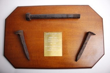
Souvenir - Burma Rail Bridge Bolt & Railway Spikes.On wooden plaque
Plaque with metal railway bridge bolt and 2 metal railway line spikes.Spikes have lip on top to hold rail lines down with chisel shaped ends to by driven into sleepers. Metal bolt used to hold railway sleepers to bridgesNo markings on spikes or bolt. Plaque brass plate engraved-: BURMA RAILWAY BRIDGE BOLT & RAILWAY SPIKES Recovered 1987 By Ex P.O.W V.X. 30397 BILL TOON Approximatly 7,000 Australians Lost Their Lives Building This Railway Line 1942-1945. -
 Ballarat Tramway Museum
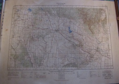
Map, Australian Survey Corps, "Victoria Ballan", 1933
Topographic map of the Ballan area - includes Bacchus Marsh and Bungaree, No. 837, Zone 7, Army Map, dated 1933, 1:63360. Shows rail lines, roads, elevations, contours. Collected with relevance to the Museum's association with the area, at Bungareetrams, tramways, bungaree, map -
 Bendigo Historical Society Inc.
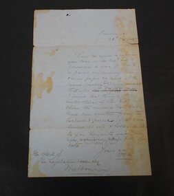
Letter - Abbott Collection: letter to Mr. Abbott
One page handwritten letter dated Sandhurst 26th February, 1868 from the Clerk of the Legislation Assembly. Melbourne. The letter describes some papers delivered by rail related to the recent election. The recipient of the letter is not mentioned only addressed as Sir.On the back: to the Clerk of the Assembly 26/02/1868letter, legislation assembly, 1868, handwritten -
 Kew Historical Society Inc
Map, Osboldstone & Co Pty Ltd, Railway and Tramway Map of Melbourne and Suburbs With Tram Timetables, 1917
The Railway and Tramway Map of Melbourne and Suburbs With Tram Timetables lists existing Cable Tram Services before the entire network was electrified. By 1917 the tramways system was divided into regions including: the Melbourne Cable Tram Service; Prahran - Malvern Electric Trams; Hawthorn Electric Trams; Melbourne, Brunswick and Coburg Electric Trams; and Brighton Beach Electric Trams. The old Outer Circle railway line is marked as ending in Deepdene, with the remainder of the line to Fairfield marked as 'Unused'. The Kew tram along High Street in 1917 ended at the Harp Junction. The Kew Spur Line is also marked on the map.The Railway and Tramway Map of Melbourne and Suburbs With Tram Timetables is historically significant as it captures at a point in time, 1917, the development of public transport infrastructure in Melbourne. As such it illustrrates the theme: Connecting Victorians by transport and communications.Printed card-covered pocket sized map that folds out with three horizontal and vertical folds. Colour map, with scale, of the rail and tram networks on one side and sixteen sections of black and white printed text and timetable information on the reverse.railway maps -- melbourne (vic.), tramways maps -- melbourne (vic.), public transport -- melbourne (vic.) -- 1910-1920, cartography -
 Surrey Hills Historical Society Collection
Photograph, 110 Croydon Road, Surrey Hills, 1980s, 1980s
This cottage was built about 1889 by Jabez Gunner. The family lived elswhere then returned to this home for many years until 1960s / 1970s.Colour photo taken from diagonally across the street of a single-fronted simple Victorian cottage. It is timber with a corrugated iron roof, canter-levered veranda and a single brick chimney. The veranda is unadorned and the fence is of simple post-and-rail construction.cottages, victorian style, croydon road, jabez gunner -
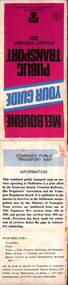
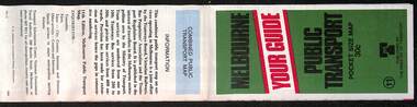
 Melbourne Tram Museum
Document, Ministry of Transport, Melbourne Public Transport Map - No. 12, 1982
Map No. 12 - Includes description of tram and bus routes, private bus routes. On the front cover is composite image of Melbourne public transport vehicles. Has contact details for bookings and lost property etc and how to use the map. Priced at 40c, issue No. 12 of c1982. Has details of the then new Travelcard ticket system. Yields information about Melbourne public transport services in 1982.Fold out map (36 sections 9 across x 4 deep), "Public Transport Map", coloured of Melbourne's Tram and Bus routes, route numbers, rail lines, detailed for the central part of Melbourne and the outer Metropolitan services.tramways, melbourne, tram services, bus services, railways, travelcard -
 Melbourne Tram Museum
Map, Ministry of Transport, Melbourne Public Transport Map - No. 9, 1979
Map No. 9 - Includes description of tram and bus routes, private bus routes. Has contact details for bookings and lost property etc and how to use the map. Yields information about Melbourne public transport services in 1979Fold out map (27 sections 9 across x 3 deep), "Public Transport Map", coloured of Melbourne's Tram and Bus routes, route numbers, rail lines, detailed for the central part of Melbourne and the outer Metropolitan services.tramways, melbourne, tram services, bus services, railways, travelcard, maps -
 Bendigo Historical Society Inc.
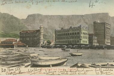
Postcard - Alice McGregor Postcard Collection, 1900 - 1920
Alice McGREGOR Born: 1908; unknown parents. Possibly adopted by the Salter family? Electoral Roll 1936: Highland Terrace Kangaroo Flat. Alice Mary Salter and William Robert Salter living together; presumed to be sister and brother. William Robert Salter was killed in a MVA in Bendigo in 1937 aged 26. In Victoria in 1938, Alice Mary Salter married James Thomas McGregor (born Victoria 1917, died Victoria 1983, buried Fawkner Cemetery) Lived: 1968; 22 Wade Street Golden Square Alice McGregor Died: 1999 aged 91 at Anne Caudle Centre, Bendigo Buried: Kangaroo Flat Cemetery See additional research. Postcard Album of Alice McGregor contained 86 post cards.Postcard Album of Alice McGregor containing 86 post cards. See 1400 Colour photo of Dock Road and Beach, Capetown, South Africa. Boats on beach in foreground. Rail wagons in front of tall buildings. Table Mountain in background. Addressed to Miss A. Stapleton, Bendigo, Australia Sender - W. Players (?) Undated postcard, collector, alice mcgregor -
 Melbourne Tram Museum
Map, Ministry of Transport, Melbourne Public Transport Map - No. 11, 1980
Map No. 11 dated on rear as 1980 - Includes description of tram and bus routes, private bus routes. Has contact details for bookings and lost property etc and how to use the map. Yields information about Melbourne public transport services in 1980Fold out map (27 sections 9 across x 3 deep), "Public Transport Map", coloured of Melbourne's Tram and Bus routes, route numbers, rail lines, detailed for the central part of Melbourne and the outer Metropolitan services.tramways, melbourne, tram services, bus services, railways, maps -
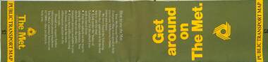 Melbourne Tram Museum
Map, The Met, Public Transport Map - Get around on The Met, c1987
Undated map - c1987 - Neighbourhood and travelcard tickets, has a photo of the front of B2 2004, includes a map of the travelcard neighbourhoods, commuter passes and The Met contact details.Yields information about Melbourne public transport services in c1987Fold out map (36 sections 9 across x 4 deep), "Public Transport Map", coloured of Melbourne's Tram and Bus routes, route numbers, rail lines, detailed for the central part of Melbourne and the outer Metropolitan services.tramways, melbourne, tram services, bus services, railways, maps, travelcard, neighbourhood tickets -
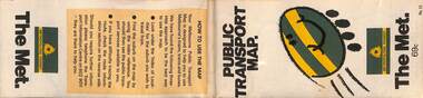 Melbourne Tram Museum
Map, The Met, "Public Transport Map - No. 13", 1984
Map No. 13 undated with the buzzing bee symbol on the front and throughout at the time of the introduction of the neighbourhoods. Includes description of tram and bus routes, private bus routes. Has contact details for bookings and lost property etc and how to use the map. Gives extensive details of the neighbourhood tickets and their used. C1984.Yields information about Melbourne public transport services in 1984.Fold out map (36 sections 9 across x 4 deep), "Public Transport Map", coloured of Melbourne's Tram and Bus routes, route numbers, rail lines, detailed for the central part of Melbourne and the outer Metropolitan services.tramways, melbourne, tram services, bus services, maps -
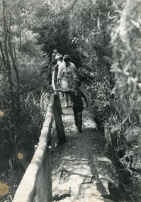 Lakes Entrance Historical Society
Photograph - Johnsonville School, 1984
Black and white photograph of two adults Lyn Winnett and Dominique (Dommie) Spiller plus children walking along bush track, pine log hand rail, at Mississippi Creek Track, on primary school picnic day. Jonsonville Victoriaschools, activities -
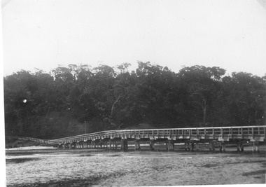 Lakes Entrance Historical Society
Photograph, North Arm bridge Lakes Entrance Victoria c1900, 1900c
Jemmies Point BridgeBlack and white photograph of the wooden bridge across the North Arm, showing the original width of the North Arm, the start of the road up to Kalimna bordered by a post and rail fence, the heights of Kalimna concealed by dense vegetation. Lakes Entrance Victoriabridges, vegetation, fences -
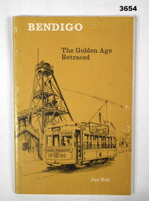 Bendigo Military Museum
Book - BOOK, BENDIGO, Brown Prior Anderson, Bendigo The Golden Age Retraced, 1980
Soft, cardboard cover. Black / white print on front, spine & back. Yellow background illustrated with sketches of the Central Deborah Mine with a tram. 63 cut, white pages. Illustrated sketches in black on white background. Front & back flyleaf & end papers. Map of Bendigo. Inscriptions.Handwritten in blue ink on title page: “25.12.80. To Dad. Merry Xmas 1980” Handwritten in blue ink on contents page: “Rail to Bgo opened Oct 21 1962 to P Hill 12 Feb 1884 a period of 22 yrs”book, bendigo, golden age, retraced