Showing 23103 items matching "sardine-creek"
-
 Eltham District Historical Society Inc
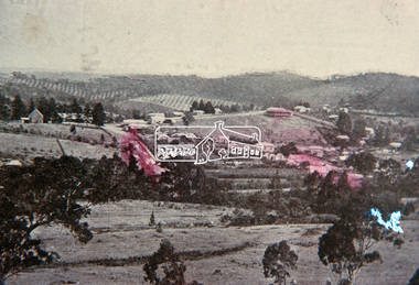
Slide, View overlooking Diamond Creek, 1907
View overlooking Diamond Creek to the northeast, most likely from near St John's Church, 190735 mm colour positive transparency of a newsprint image taken c.1970 Mount - Kodak Kodachrome Card13diamond creek township -
 Eltham District Historical Society Inc
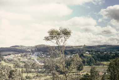
Slide, View overlooking Diamond Creek, 1970
View overlooking Diamond Creek to the northeast, most likely from near St John's Church, 197035 mm colour positive transparency of a newsprint image taken c.1970 Mount - Kodak Kodachrome Card27diamond creek township -
 Eltham District Historical Society Inc
Photograph, Gold Memorial Cairn, Andersons Creek; Warrandyte Mystery Tour, 29 May 1994, 29/05/1994
The Cairn commemorates the disclosure of Gold Discovery at Warrandyte on June 30th 1851 beside Anderson's Creek RoadColour photographactivities, gold memorial cairn, warrandyte, andersons creek -
 Stawell Historical Society Inc
Photograph, Pleasant Creek -- Stawell Hospital Infectious Diseases Ward -- Syme Ward Opened 1904
Pleasant Creek. Stawell Hospital Infectious Diseases Ward Syme Ward Opened 1904 Nurses in Frontstawell hospital medical -
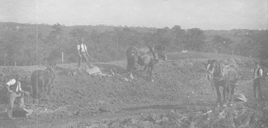
 Stawell Historical Society Inc
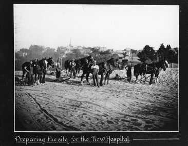
Photograph, Pleasant Creek -- Stawell Hospital site being prepared with workmen & horse drawn levellers
Pleasant Creek. Stawell Hospital Workmen on New Hospital Site preparing the site with horse drawn levellers.stawell hospital -
 Stawell Historical Society Inc
Photograph, Pleasant Creek -- Stawell Hospital Infectious Diseases Ward -- Syme Ward Opened 1904
Pleasant Creek. Stawell Hospital Infectious Diseases Ward Syme Ward Opened 1904 Nurses in Frontstawell hospital medical -
 Stawell Historical Society Inc
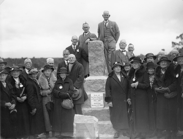
Photograph, Cemetery Memorial erected at One Tree Hill Cemetery at Pleasant Creek 1935 Colour Photgraph
Group of people at original cemetery. One Tree Hill Cemetery Pleasant Creek. Memorial erected 1935stawell -
 Stawell Historical Society Inc
Photograph, Original Cemetery Memorial erected at One Tree Hill Cemetery at Pleasant Creek 1935
Group of people at original cemetery. One Tree Hill Cemetery Pleasant Creek. Memorial erected 1935stawell -
 Stawell Historical Society Inc
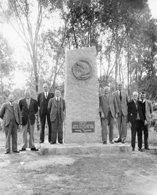
Photograph, Stawell Progress Association Members beside the Gold Memorial monument to the discovery of gold at Pleasant Creek 1953
Stawell Progress Association Members 1953 beside Gold Memorial monument to the discovery of gold at Pleasant Creek.stawell -
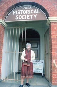 Stawell Historical Society Inc
Photograph, Dorothy Brumby – President Stawell Historical Society on the steps of old Pleasant Creek Court House 2015
Dorothy Brumby – President Stawell Historical Society 2015 on steps of old Pleasant Creek Court House stawell portrait -
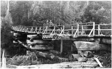 Eltham District Historical Society Inc
Negative - Photograph, Log bridge over Pheasant Creek, Kinglake, c.1920
Horse and cart with driver Mr. F. Thomson and passenger cross a wooden bridge with log tree trunk base construction supported by timber rails over Johnstone's Creek amidst the Kinglake forest. The bridge was built for the timber tramline. There was also a logging district in the Pheasant Creek area just outside the Shire of Eltham. Note dog also sitting on bridge.This photo forms part of a collection of photographs gathered by the Shire of Eltham for their centenary project book,"Pioneers and Painters: 100 years of the Shire of Eltham" by Alan Marshall (1971). The collection of over 500 images is held in partnership between Eltham District Historical Society and Yarra Plenty Regional Library (Eltham Library) and is now formally known as 'The Shire of Eltham Pioneers Photograph Collection.' It is significant in being the first community sourced collection representing the places and people of the Shire's first one hundred years.Digital image 4 x 5 inch B&W Neg 120 format B&W negative (spare) 2 x printsbridge, f. thomson, kinglake, log bridge, mr. munro, pheasant creek, pioneers and painters, shire of eltham pioneers photograph collection, timber tramway -
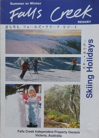 Falls Creek Historical Society
Booklet - Falls Creek Resort Skiing Holidays 1992
This booklet is part of an annual promotional campaign for Falls Creek. It contains headings and sentences of information in Japanese, which reflects the increase in international tourism and marketing. It was designed by the Falls Creek Independent Property Owners, Victoria. The information panel on the back cover indicates it was part of Australia's Southern Region Tourism Promotion C/O Australian Tourism Commission in Tokyo, Japan.This item is important as it documents seasonal activities at Falls Creek and a changing approach to international marketing. An A4 sized marketing booklet, including images and advertising information printed on glossy paper. This publication includes headings and short lines of texts in Japanese script.falls creek marketing, falls creek information, falls creek international tourism, falls creek holiday brochures -
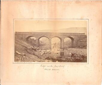 Hume City Civic Collection
Photograph, c. 1870s - 1880s
The phtograph was taken by Alfred Sinel who was the local photgrapher in Sunbury. The four arched bridge spans the river at Deep Creek, Bulla. The bridge replaced the forde crossing which is in the foreground of the photograph. Alfred Sinel is listed in the 1874 rate book as a photographer - artist.A mounted sepia photograph of the four-arched bluestone bridge over Deep Creek at Bulla. A man is standing under the 3rd arch from the LHS. The cream mount has a ruled ink frame around the photo. The caption has been hand-written under the photograph.BRIDGE OVER THE DEEP CREEK / BULLA BULLAdeep creek, bridges, bulla, sunbury, sinel, alfred, photographers, george evans collection -
 Eltham District Historical Society Inc
Negative - Photograph, J.A. McDonald, Henley Road at Watsons Creek, Apr. 1961
Henley Road at Watsons Creek looking easterly along centreline from west abutment Early April 1961Record of various Shire of Eltham infrastructure works undertaken during the period of 1952-1962 involving bridge and road reconstruction projects, sometimes with Eltham Shire Council Project Reference numbers quoted. It was during this period that a number of significant improvements were made to roads and new bridges constructed within the shire that remain in place as of present day (2022). In many situations, the photos provide a tangible visible record of infrastructure that existed throughout the early days of the Shire. The album was put together by or under the direction of the Shire Engineer, J.A. McDonald.infrastructure, shire of eltham, bend of islands, cr. charis pelling, henley road, henley road bridge, kangaroo ground, oxley bridge, watsons creek, w.e. wolf, bridge construction, road construction, 1961-04 -
 Eltham District Historical Society Inc
Negative - Photograph, J.A. McDonald, Henley Road at Watsons Creek, Apr. 1961
Henley Road at Watsons Creek looking westerly along centreline from east abutment Early April 1961Record of various Shire of Eltham infrastructure works undertaken during the period of 1952-1962 involving bridge and road reconstruction projects, sometimes with Eltham Shire Council Project Reference numbers quoted. It was during this period that a number of significant improvements were made to roads and new bridges constructed within the shire that remain in place as of present day (2022). In many situations, the photos provide a tangible visible record of infrastructure that existed throughout the early days of the Shire. The album was put together by or under the direction of the Shire Engineer, J.A. McDonald.infrastructure, shire of eltham, bend of islands, cr. charis pelling, henley road, henley road bridge, kangaroo ground, oxley bridge, watsons creek, w.e. wolf, bridge construction, road construction, 1961-04 -
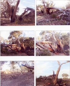 Stawell Historical Society Inc
Photograph, Lightning Strike at Sheep Wash Creek in Campbells Bridge 2005 -- Coloured
Series of six colour photographs. Tree after Lightning Strike. Sheep wash Creek 26/1/2005 -
 Ringwood and District Historical Society
Photograph, Roadmaking by McGivens, Warrandyte Rd. just north of Mullum Creek. Easier to camp on job rather than take horses and machinery to and from Croydon. 1920s
Typed below photograph, "Roadmaking in Ringwood in the 1920s." Catalogue card reads, "Roadmaking by McGivens, Warrandyte Rd. just north of Mullum Creek. Easier to camp on job rather than take horses and machinery to and from Croydon." -
 Eltham District Historical Society Inc
Photograph, Sketch of man on bridge over creek, 1971
Sketch of a man with a fishing pole standing on a bridge over a creek, stream or river in a bush setting. Unidentified artist and location.This photo forms part of a collection of photographs gathered by the Shire of Eltham for their centenary project book, "Pioneers and Painters: 100 years of the Shire of Eltham" by Alan Marshall (1971). The collection of over 500 images is held in partnership between Eltham District Historical Society and Yarra Plenty Regional Library (Eltham Library) and is now formally known as 'The Shire of Eltham Pioneers Photograph Collection.' It is significant in being the first community sourced collection representing the places and people of the Shire's first one hundred years.Digital imagesepp, shire of eltham pioneers photograph collection, fishing, creek, sketch, tranquil, unidentified, other areas, bush, outdoors, country life -
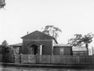
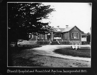 Stawell Historical Society Inc
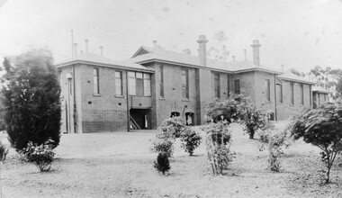
Photograph, Pleasant Creek -- Stawell Hospital and Benevolent Asylum c1897
Pleasant Creek Hospital and Benevolent Asylum. Stawell Hospital First Permanent Building Incorporated 1897. Nurses seated on lawn.stawell hospital medical -
Stawell Historical Society Inc
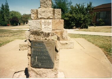
Photograph, Close up or plaque, First Cemetery, One Tree Hill Cemetery, Pleasant Creek. Photographic Committee National Trust Photographs of Stawell
7006 National Trust Photographs Close up or plaque, First Cemetery, One Tree Hill Cemetery, Pleasant Creek Series of Colour Photographs of buildings of interest to National TrustJune 1993buildings, heritage buildings -
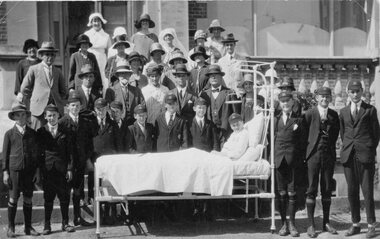
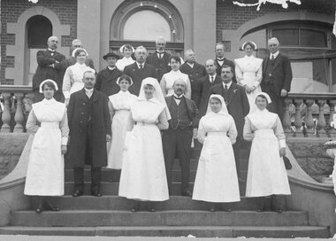 Stawell Historical Society Inc
Photograph, Pleasant Creek Hospital Doctors, Nurses & Committee whilst unveiling the Honour Roll 1917-1918
Pleasant Creek Hospital Doctors. Nurses & Committee on front steps of hospital on the occasion of unveiling the Honour Roll 1917-1918stawell -
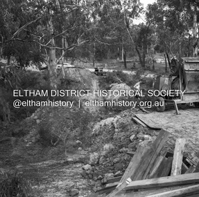
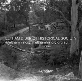
 Eltham District Historical Society Inc
Negative - Photograph, Construction of the new concrete bridge over the Diamond Creek on Main Road, Eltham, c.May 1926
Construction of the new concrete bridge over the Diamond Creek on Main Road, Eltham, c.May 1926. Viewed from present day Wingrove Park. The original long suspension bridge over the Diamond Creek on Main Road at Eltham collapsed during flooding of the Diamond Creek on October 13 and 14, 1923. The original bridge was built around 1840 for the coach road when Cobb & Co.'s coach was the only conveyance between Eltham and Melbourne. Widespread damage was done in Melbourne and surrounding areas by floods resulting from the overflow of the Yarra at many points along its banks. A temporary bridge rigged up was severely damaged by the flooding of the creek and was closed to vehicular traffic in April 1924. A new concrete bridge was constructed to replace it and by May 1926 all the concrete piles and abutments had been completed. The bridge was finally completed and opened for traffic in September 1926, almost three years after it initially collapsed.This photo forms part of a collection of photographs gathered by the Shire of Eltham for their centenary project book,"Pioneers and Painters: 100 years of the Shire of Eltham" by Alan Marshall (1971). The collection of over 500 images is held in partnership between Eltham District Historical Society and Yarra Plenty Regional Library (Eltham Library) and is now formally known as the 'The Shire of Eltham Pioneers Photograph Collection.' It is significant in being the first community sourced collection representing the places and people of the Shire's first one hundred years.Digital image 4 x 5 inch B&W Neg Print 9 x 12.5 cmshire of eltham pioneers photograph collection, eltham, eltham lower park, main road bridge, eltham south, bridge, diamond creek (creek), wingrove park, bridge construction -
 Bayside Gallery - Bayside City Council Art & Heritage Collection
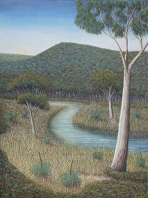
Painting - oil and acrylic on canvas, Robert Kelly, Chinaman's Creek, 2016
Bob Kelly paints landscapes of culturally significant sites along the Mornington Peninsula and depicts these locations as he imagines they originally were before colonisation. Using traditional Western painting techniques, Kelly records the underlying spirit of the Peninsula from a Wathaurong perspective. Chinaman’s Creek in Capel Sound (Rosebud West) was an important watercourse that originally ran from Wonga (Arthur’s Seat) down through Tootgarook Swamp into Port Phillip Bay. It was a great fresh water and food source and home for many Boonwurrung people. Since settlement over 170 years ago, the creek has been drained, blocked, reconstructed and damaged. Kelly depicts a lush green landscape in which the clean creek water winds through the surrounding vegetation of spinifex grasses and gum trees, the background hills are abundant with trees, untouched from man's intervention. Using painstaking detail, Kelly records each blade of grass and ripple on the surface of Chinaman’s Creek. His attention to detail serves to powerfully reimagine this important cultural site, returning it to its former pristine state, and reinvigorating its role as a key place of sustenance for the Indigenous populations of the Peninsula. Chinaman's Creek was a finalist in the 2017 Bayside Acquisitive Art Prize.oil and acrylic on canvaslandscape, creek, trees, chinaman's creek, painting, indigenous, robert kelly, bayside acquisitive art prize, bob kelly, wathaurong, rosebud, arthur's seat, tootgarook swamp, port phillip bay, boonwurrung -
 Bendigo Historical Society Inc.
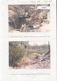
Photograph - Kangaroo Flat Gold Mine Collection: Deadhorse Gully, Sydney Flat Creek March 1986
Colour photographs, seventeen images on nine page. Images labelled as follows : 1. North New Moon shaft - natural discharge point of Garden Gullly line 2. Actual exit to surface from beneath mullock at North New Moon shaft. 3. Looking into Deadhorse Gully from mullock heap at North New Moon site. 4. Deadhorse Gully downstream of WMC Weir. 5. Sydney Creek track crossing - impassable ford. 6. Sydney Creek looking downstream from ford. 7. Sydney Creek looking upstream from road near Recreation Reserve (12 inch pipe under road). 8. Sydney Creek looking downstream from same point. 9. Sydney Creek - Camp Road, looking upstream.. 10. Sydney Creek - Camp Road, looking downstream. 11. Sydney Creek - Camp Road Culverts. 12. Sydney Creek - Pyramid Road Bridge, looking upstream. 13. Sydney Creek - Pyramid Road Crossing looking downsteam. 14. Sydney Creek - rail crossing, looking upstream. 15. Sydney Creek - rail crossing, looking downstream. 16. Sydney Creek - Airstrip road, looking upstream. 17. Sydney Creek - Airstrip Road, looking downstream 12 inch pipe under road. Lined paper, in blue pen 'Deadhorse Gully-Sydney Flat Creek, March 1986, Photos of Deadhorse Gully/Sydney Flat Creek'kangaroo flat gold mine, deadhorse gully, sydney flat creek, unity mining, water discharge, north new moon, camp road, pyramid hill road, eaglehawk -
 Kiewa Valley Historical Society
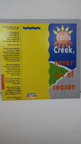
Brochure - Falls Creek Tourism, Falls Creek Never Out of Season
Falls Creek is a Ski Resort in the north east of Victoria. This brochure has been produced to encourage tourists to visit throughout the year.Tourism to the Kiewa Valley is an important industry for the area. Falls Creek is a ski resort with accommodation during winter for skiers, snow boarders and other snow sports. It involves entertainment, restaurants and associated workers. This brochure is produced to promote the resort throughout the year to increase the occupancy of these lodges. The tourist industry has increased steadily with fishing, cycling and bush walking increasing numbers in the area.Glossy square brochure folded in in half and half again. Front page is yellow on the left with black print on the far left. The right side has the title with blue, green and grey background with yellow, orange and white as part of the title. The back is a man standing in front of a sunset with print in a column towards the right side. Inside includes a map with advertisements for accommodation surrounding it.falls creek ski resort; alpine region in victoria; mountain lodges; -
 Greensborough Historical Society
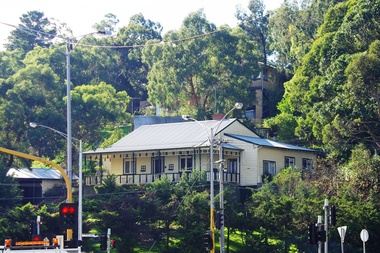
Photograph - Digital image, Dr Woods House corner St Helena and Diamond Creek Roads Greensborough, 21/05/2014
A landmark house in the Greensborough area (belonging to Dr Woods in he 1920s), situated on the corner of Diamond Creek and St Helena Roads.Digital copy of colour photograph.diamond creek road, st helena road -
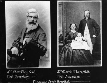 Stawell Historical Society Inc
Photograph, Pleasant Creek -- Stawell Hospital with Mr Chas Playford as first Secretary & Mr Martin Thornfeldt and family as First Dispenser -- Studio Portraits -- 2 Photos
Pleasant Creek. Stawell Hospital Portraits Mr. Chas Playford First Secretary. Mr. Martin Thornfeldt and family First Dispenser.stawell hospital medical -
 Stawell Historical Society Inc
Photograph, Pleasant Creek Courthouse in Longfield Street Stawell c1900
Pleasant Creek Courthouse Longfield Street with wooden kitchen extension when being used as a mounted constables quarters. Possibly 1900.stawell government -
 Stawell Historical Society Inc
Photograph, Pleasant Creek Hospital & a Presentation of a bed by the Stawell Technical School 1926
Pleasant Creek Hospital 1926 Presentation of bed by Stawell Technical School made by mothers club Primary School 502 of bed.stawell education medical