Showing 5882 items
matching residential
-
 Eltham District Historical Society Inc
Journal - Newsletter, Nillumbik Shire Council, Nillumbik News, October 2000
October 2000 articles include: Safer roads for the Shire Eltham Festival program announced Commercial Place design released 2000-2003 Council Plan Released National Reconciliation Framework Living and Learning Centres More Playgrounds Susan St Pavilion completed Study to plan for BMX/skate track Wattle Glen Township Strategy Community Weed Control Program Count Koala Day Environment Centre proposed for Edendale Farm Open Space Strategy findings Neighbourhood Character Study and Residential Design Guidelines Friends groups Clean Drains – Living Creeks, National Water Week Nillumbik Shire Council Cultural Plan 2000-2005 adopted 2001 Alan Marshall Short Story Award Artists’ Open Studios program Kangaroo Ground Tower Advisory Committee Environment leaders at Eltham North primary Dollars saved by regular road maintenance Regional Road upgrades Rural roads grading program Stormwater Management Plan Locality boundary update council newsletters, nillumbik news, nillumbik shire council -
 Old Colonists' Association of Ballarat Inc.
Photograph - Image, Clare Gervasoni, Ballarat Old Colonists' Association Residence - Barker Home, 07/12/2018
This home was completed in 1938. It was the gift of Mr and Mrs Barker. One of the first objectives of the Association was "to provide the shelter of a hose for those Pioneers of the Goldfields whom the reverses of fortune have deprived of the means of procuring the comforts of life in their declining years." The first home at Charles Anderson Grove was built in 1925. Before that time the Association provided relief for needy pioneers. relief included monthly monetary payments, loads of firewood, medical assistance and distribution of Christmas bosed of groceries to deserving pensioners, and in some cases payment of burial costs. ::a) The dominant purpose of the Association is to give public benevolent relief as a charity, but providing independent living accommodation in our Retirement Village for person in need who are over 65. ::b) To raise funds by membership subscription, commercial and residential rents, donations, gifts and voluntary work, for the purpose of providing direct relief of poverty, distress, misfortune or helplessness. ::c) To maintain the important heritage and ongoing viability of the Old Colonists' Association. (Revised Rules of the Old Colonists' Association of Ballarat Inc., 2016) Colour photograph of Barker Cottage at The Old Colonists' Assiation of Ballarat Inc retirement village at Charles Anderson Grove, Ballarat.old colonists' association, ballarat, ballarat old colonists' club, charles anderson grove, barker, barker cottage, j. barker -
 Old Colonists' Association of Ballarat Inc.
Photograph - Image, Clare Gervasoni, https://cms.victoriancollections.net.au/catalogue/items, 2016
The Wilson homes were completed in 1966. One of the first objectives of the Association was "to provide the shelter of a hose for those Pioneers of the Goldfields whom the reverses of fortune have deprived of the means of procuring the comforts of life in their declining years." The first home at Charles Anderson Grove was built in 1925. Before that time the Association provided relief for needy pioneers. relief included monthly monetary payments, loads of firewood, medical assistance and distribution of Christmas bosed of groceries to deserving pensioners, and in some cases payment of burial costs. ::a) The dominant purpose of the Association is to give public benevolent relief as a charity, but providing independent living accommodation in our Retirement Village for person in need who are over 65. ::b) To raise funds by membership subscription, commercial and residential rents, donations, gifts and voluntary work, for the purpose of providing direct relief of poverty, distress, misfortune or helplessness. ::c) To maintain the important heritage and ongoing viability of the Old Colonists' Association. (Revised Rules of the Old Colonists' Association of Ballarat Inc., 2016) Colour photograph pf a cream brick building known as the Wilson Homes. They are a part of the Old Colonists' Association, Ballarat Retirement Village at Charles Anderson Grove. old colonists' association, ballarat, ballarat old colonists' club, charles anderson grove, wilson, wilson homes -
 Old Colonists' Association of Ballarat Inc.
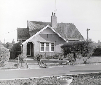
Photograph - Image, Ballarat Old Colonists' Association Residence - Permewan Cottage, 2016, 2016
This cottage was completed in 1956. One of the first objectives of the Association was "to provide the shelter of a hose for those Pioneers of the Goldfields whom the reverses of fortune have deprived of the means of procuring the comforts of life in their declining years." The first home at Charles Anderson Grove was built in 1925. Before that time the Association provided relief for needy pioneers. relief included monthly monetary payments, loads of firewood, medical assistance and distribution of Christmas bosed of groceries to deserving pensioners, and in some cases payment of burial costs. ::a) The dominant purpose of the Association is to give public benevolent relief as a charity, but providing independent living accommodation in our Retirement Village for person in need who are over 65. ::b) To raise funds by membership subscription, commercial and residential rents, donations, gifts and voluntary work, for the purpose of providing direct relief of poverty, distress, misfortune or helplessness. ::c) To maintain the important heritage and ongoing viability of the Old Colonists' Association. (Revised Rules of the Old Colonists' Association of Ballarat Inc., 2016) Colour photograph of Permewan Cottage at The Old Colonists' Assiation of Ballarat Inc retirement village at Charles Anderson Grove, Ballarat.old colonists' association, ballarat, ballarat old colonists' club, charles anderson grove, permewan, permewan cottage, retirement village -
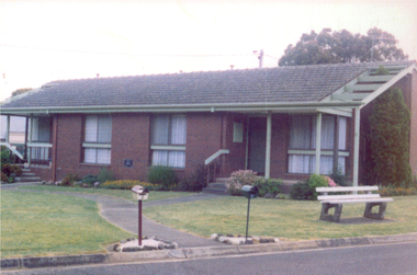
 Old Colonists' Association of Ballarat Inc.
Image, Ballarat Old Colonists' Association Retirement Village - Joe White Homes, 23/09/2017
These homes were built in 1969. One of the first objectives of the Association was "to provide the shelter of a those for those Pioneers of the Goldfields whom the reverses of fortune have deprived of the means of procuring the comforts of life in their declining years." The first home at Charles Anderson Grove was built in 1925. Before that time the Association provided relief for needy pioneers. relief included monthly monetary payments, loads of firewood, medical assistance and distribution of Christmas bosed of groceries to deserving pensioners, and in some cases payment of burial costs. ::a) The dominant purpose of the Association is to give public benevolent relief as a charity, but providing independent living accommodation in our Retirement Village for person in need who are over 65. ::b) To raise funds by membership subscription, commercial and residential rents, donations, gifts and voluntary work, for the purpose of providing direct relief of poverty, distress, misfortune or helplessness. ::c) To maintain the important heritage and ongoing viability of the Old Colonists' Association. (Revised Rules of the Old Colonists' Association of Ballarat Inc., 2016) The Joe White Cottage in the Ballarat Old Colonists' Association Retirement Village.old colonists' association, ballarat, ballarat old colonists' club, joe white, charles anderson grove, joe white cottage -
 Old Colonists' Association of Ballarat Inc.
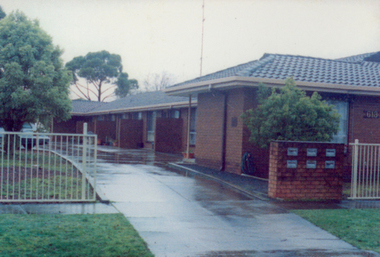
Photograph - Image, Clare Gervasoni, Ballarat Old Colonists' Association Retirement Village Residence - Ian Rollo Currie Foundation Homes, 2016
These homes were built in 1981. One of the first objectives of the Association was "to provide the shelter of a hose for those Pioneers of the Goldfields whom the reverses of fortune have deprived of the means of procuring the comforts of life in their declining years." The first home at Charles Anderson Grove was built in 1925. Before that time the Association provided relief for needy pioneers. relief included monthly monetary payments, loads of firewood, medical assistance and distribution of Christmas bosed of groceries to deserving pensioners, and in some cases payment of burial costs. ::a) The dominant purpose of the Association is to give public benevolent relief as a charity, but providing independent living accommodation in our Retirement Village for person in need who are over 65. ::b) To raise funds by membership subscription, commercial and residential rents, donations, gifts and voluntary work, for the purpose of providing direct relief of poverty, distress, misfortune or helplessness. ::c) To maintain the important heritage and ongoing viability of the Old Colonists' Association. (Revised Rules of the Old Colonists' Association of Ballarat Inc., 2016) Colour photograph of the Ian Rollo Currie Foundation Cottage at The Old Colonists' Assiation of Ballarat Inc retirement village at Charles Anderson Grove, Ballarat.old colonists' association, ballarat, ian rollo currie foundation, charles anderson grove, ian rollo currie homes, old colonists' association retirement village -
 Old Colonists' Association of Ballarat Inc.
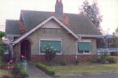
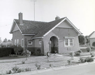
Photograph - Image, Clare Gervasoni, Ballarat Old Colonists' Association Retirement Village Residence - Crombie Cottage, 2016
This cottage was built in 1932. One of the first objectives of the Association was "to provide the shelter of a hose for those Pioneers of the Goldfields whom the reverses of fortune have deprived of the means of procuring the comforts of life in their declining years." The first home at Charles Anderson Grove was built in 1925. Before that time the Association provided relief for needy pioneers. relief included monthly monetary payments, loads of firewood, medical assistance and distribution of Christmas bosed of groceries to deserving pensioners, and in some cases payment of burial costs. ::a) The dominant purpose of the Association is to give public benevolent relief as a charity, but providing independent living accommodation in our Retirement Village for person in need who are over 65. ::b) To raise funds by membership subscription, commercial and residential rents, donations, gifts and voluntary work, for the purpose of providing direct relief of poverty, distress, misfortune or helplessness. ::c) To maintain the important heritage and ongoing viability of the Old Colonists' Association. (Revised Rules of the Old Colonists' Association of Ballarat Inc., 2016) Colour photograph of Crombie Cottage at The Old Colonists' Assiation of Ballarat Inc retirement village at Charles Anderson Grove, Ballarat.old colonists' association, ballarat, charles anderson grove, crombie, crombie cottage, retirement village -
 Old Colonists' Association of Ballarat Inc.
Image, Ballarat Old Colonists' Association Residence - Unit 1-6 Ascot Street, Ballarat, c2000
These units were built in 1991. One of the first objectives of the Association was "to provide the shelter of a hose for those Pioneers of the Goldfields whom the reverses of fortune have deprived of the means of procuring the comforts of life in their declining years." The first home at Charles Anderson Grove was built in 1925. Before that time the Association provided relief for needy pioneers. relief included monthly monetary payments, loads of firewood, medical assistance and distribution of Christmas bosed of groceries to deserving pensioners, and in some cases payment of burial costs. ::a) The dominant purpose of the Association is to give public benevolent relief as a charity, but providing independent living accommodation in our Retirement Village for person in need who are over 65. ::b) To raise funds by membership subscription, commercial and residential rents, donations, gifts and voluntary work, for the purpose of providing direct relief of poverty, distress, misfortune or helplessness. ::c) To maintain the important heritage and ongoing viability of the Old Colonists' Association. (Revised Rules of the Old Colonists' Association of Ballarat Inc., 2016) Colour photograph of the former Old Colonists' Association of Ballarat Inc homes in Ascot Street, Ballarat.ballarat old colonists' association, homes, ascot street units -
 Old Colonists' Association of Ballarat Inc.
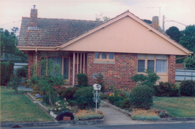
Photograph - Image, Thornton Richards, Ballarat Old Colonists' Association Retirement Village Residence - Permewan Cottage, c1982, 2016
This cottage was completed in 1956. One of the first objectives of the Association was "to provide the shelter of a hose for those Pioneers of the Goldfields whom the reverses of fortune have deprived of the means of procuring the comforts of life in their declining years." The first home at Charles Anderson Grove was built in 1925. Before that time the Association provided relief for needy pioneers. relief included monthly monetary payments, loads of firewood, medical assistance and distribution of Christmas bosed of groceries to deserving pensioners, and in some cases payment of burial costs. ::a) The dominant purpose of the Association is to give public benevolent relief as a charity, but providing independent living accommodation in our Retirement Village for person in need who are over 65. ::b) To raise funds by membership subscription, commercial and residential rents, donations, gifts and voluntary work, for the purpose of providing direct relief of poverty, distress, misfortune or helplessness. ::c) To maintain the important heritage and ongoing viability of the Old Colonists' Association. (Revised Rules of the Old Colonists' Association of Ballarat Inc., 2016) Black and White photograph of Permewan Cottage at The Old Colonists' Assiation of Ballarat Inc retirement village at Charles Anderson Grove, Ballarat.old colonists' association, ballarat, ballarat old colonists' club, charles anderson grove, permewan, permewan cottage, retirement village -
 Old Colonists' Association of Ballarat Inc.
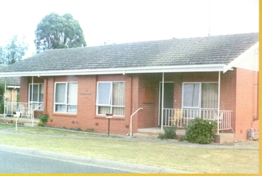
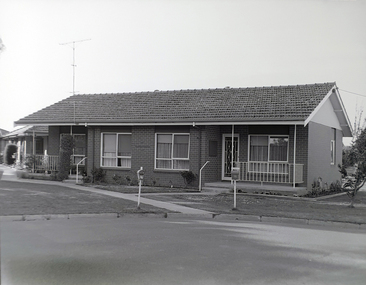
Photograph - Image, Thornton Richards, Wilson Homes at the Old Colonists' Association Retirement Village, c1982, c1982
The Wilson homes were completed in 1966. One of the first objectives of the Association was "to provide the shelter of a hose for those Pioneers of the Goldfields whom the reverses of fortune have deprived of the means of procuring the comforts of life in their declining years." The first home at Charles Anderson Grove was built in 1925. Before that time the Association provided relief for needy pioneers. relief included monthly monetary payments, loads of firewood, medical assistance and distribution of Christmas bosed of groceries to deserving pensioners, and in some cases payment of burial costs. ::a) The dominant purpose of the Association is to give public benevolent relief as a charity, but providing independent living accommodation in our Retirement Village for person in need who are over 65. ::b) To raise funds by membership subscription, commercial and residential rents, donations, gifts and voluntary work, for the purpose of providing direct relief of poverty, distress, misfortune or helplessness. ::c) To maintain the important heritage and ongoing viability of the Old Colonists' Association. (Revised Rules of the Old Colonists' Association of Ballarat Inc., 2016) Black and white photograph pf a cream brick building known as the Wilson Homes. They are a part of the Old Colonists' Association, Ballarat Retirement Village at Charles Anderson Grove. old colonists' association, ballarat, ballarat old colonists' club, charles anderson grove, wilson, wilson homes -
 Old Colonists' Association of Ballarat Inc.
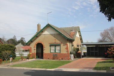
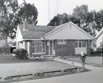
Photograph - Image, Thornton Richards, Ballarat Old Colonists' Association Retirement Village Residence - Barker Home, c1982, c1982
This home was completed in 1938. It was the gift of Mr and Mrs Barker. One of the first objectives of the Association was "to provide the shelter of a hose for those Pioneers of the Goldfields whom the reverses of fortune have deprived of the means of procuring the comforts of life in their declining years." The first home at Charles Anderson Grove was built in 1925. Before that time the Association provided relief for needy pioneers. relief included monthly monetary payments, loads of firewood, medical assistance and distribution of Christmas bosed of groceries to deserving pensioners, and in some cases payment of burial costs. ::a) The dominant purpose of the Association is to give public benevolent relief as a charity, but providing independent living accommodation in our Retirement Village for person in need who are over 65. ::b) To raise funds by membership subscription, commercial and residential rents, donations, gifts and voluntary work, for the purpose of providing direct relief of poverty, distress, misfortune or helplessness. ::c) To maintain the important heritage and ongoing viability of the Old Colonists' Association. (Revised Rules of the Old Colonists' Association of Ballarat Inc., 2016) Colour photograph of Barker Cottage at The Old Colonists' Assiation of Ballarat Inc retirement village at Charles Anderson Grove, Ballarat.old colonists' association, ballarat, ballarat old colonists' club, charles anderson grove, barker, barker cottage, j. barker -
 Old Colonists' Association of Ballarat Inc.
Photograph - Image, Thornton Richards, Ballarat Old Colonists' Association Retirement Village Residence - Crombie Cottage, c1982
This cottage was built in 1932. One of the first objectives of the Association was "to provide the shelter of a hose for those Pioneers of the Goldfields whom the reverses of fortune have deprived of the means of procuring the comforts of life in their declining years." The first home at Charles Anderson Grove was built in 1925. Before that time the Association provided relief for needy pioneers. relief included monthly monetary payments, loads of firewood, medical assistance and distribution of Christmas bosed of groceries to deserving pensioners, and in some cases payment of burial costs. ::a) The dominant purpose of the Association is to give public benevolent relief as a charity, but providing independent living accommodation in our Retirement Village for person in need who are over 65. ::b) To raise funds by membership subscription, commercial and residential rents, donations, gifts and voluntary work, for the purpose of providing direct relief of poverty, distress, misfortune or helplessness. ::c) To maintain the important heritage and ongoing viability of the Old Colonists' Association. (Revised Rules of the Old Colonists' Association of Ballarat Inc., 2016) Black and white photograph of Crombie Cottage at The Old Colonists' Association of Ballarat Inc retirement village at Charles Anderson Grove, Ballarat.old colonists' association, ballarat, charles anderson grove, crombie, crombie cottage, retirement village -
 Old Colonists' Association of Ballarat Inc.
Photograph - Image, Thornton Richards, Ballarat Old Colonists' Association Retirement Village Residence - Ian Rollo Currie Foundation Homes, 1982
These homes were built in 1981. One of the first objectives of the Association was "to provide the shelter of a hose for those Pioneers of the Goldfields whom the reverses of fortune have deprived of the means of procuring the comforts of life in their declining years." The first home at Charles Anderson Grove was built in 1925. Before that time the Association provided relief for needy pioneers. relief included monthly monetary payments, loads of firewood, medical assistance and distribution of Christmas bosed of groceries to deserving pensioners, and in some cases payment of burial costs. ::a) The dominant purpose of the Association is to give public benevolent relief as a charity, but providing independent living accommodation in our Retirement Village for person in need who are over 65. ::b) To raise funds by membership subscription, commercial and residential rents, donations, gifts and voluntary work, for the purpose of providing direct relief of poverty, distress, misfortune or helplessness. ::c) To maintain the important heritage and ongoing viability of the Old Colonists' Association. (Revised Rules of the Old Colonists' Association of Ballarat Inc., 2016) Black and white photograph of the Ian Rollo Currie Foundation Cottage at The Old Colonists' Assiation of Ballarat Inc retirement village at Charles Anderson Grove, Ballarat.old colonists' association, ballarat, ian rollo currie foundation, charles anderson grove, ian rollo currie homes, old colonists' association retirement village -
 Kew Historical Society Inc
Plan - Subdivision Plan, J R Mathers & McMillan, Plan of Subdivision of Part of Crown Portion 83 at Kew : LP6669, 1923-1939
In 1888, in the section of Park Hill Road between Belmont Avenue and Normanby Road there was only one street running between Park Hill Road and Cotham Road. This was Park Road, later to be named Adeney Avenue. Subsequent 20th century subdivisions created the ‘through roads’ of Cecil Street, Wimba Avenue, Florence Avenue, Marshall Avenue, Uvadale Road, and Barrington Avenue. This subdivision represents an attempt by auctioneers, rather than town planners to create an urban environment from larger residential allotments or in many cases farmland. Existing streets such as Parkhill and Normanby Roads provided a convenient starting point for the surveyors, but the Road named ‘Street Street’ indicates the role of the private surveyor in creating streets. Given that a number of allotments are listed as sold on the plan, the street is presumably Cecil Street. Even those lots that had been sold do not quite match the dimensions of the blocks in this parcel of land today, indicating that either further subdivisions or boundary alterations occurred.Subdivision plans are historically important documents used as evidence for the growth of suburbs in Australia. They frequently provide information about when the land was sold as well as evidence relating to surveyors and real estate and financial agents. The numerous subdivision plans in the Kew Historical Society's collection represent working documents, ranging from the initial sketches made in planning a subdivision to printed plans on which auctioneers or agents listed the prices for which individual lots were sold. In a number of cases, the reverse of a subdivision plan in the collection includes a photograph of a house that was also for sale by the agent. These photographs provide significant heritage information relating house design and decoration, fencing and household gardens.The photograph may also be aesthetically significant depending on the importance of the photographic atelier.Hand-drawn subdivision plan of 19 lots facing Parkhill Road, Normanby Road, and an unnamed street [now Cecil Street] in Kew.Estate Agent notes in ink indicate those lots which had sold.subdivision plans - kew, parkhill road - kew, cecil street - kew, normanby road - kew, cecil street -kew, parkhill road - kew, normanby road - kew, crown portion 83 - kew -
 Vision Australia
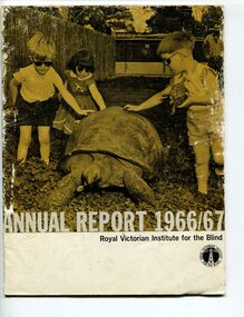
Administrative record - Text, Royal Victorian Institute for the Blind annual report 1966-1967, 1966-1967
Articles in annual report include: Office bearers of the institute/officers, President's report - 100 years, Residence nursery and school for blind children - in 1866 first nine blind children were accommodated in temporary premises in Commercial Road Prahran, the budget was $822 pounds, now the facility in Burwood can house 70 children and the, budget is $160,000, New found confidence after rehabilitation, Blind welfare work increases, Our factory now serves industry, Employ opportunities are widening, Our loyal auxiliaries and other supporters, What of the future, Income and expenditure, Where there's a will there's a way to help blind people. Events that occurred in 1966 : Millet broom making was discontinued and mat and industrial brush making and packing and assembly began, the Governor of Victoria and Lady Delacombe brought their dog to visit the children at the school, the Institute began two vital new projects - providing a residential geriatric facility and to establish the RVIB foundation for research and education.1 volume of print and illustrationsannual reports, royal victorian institute for the blind -
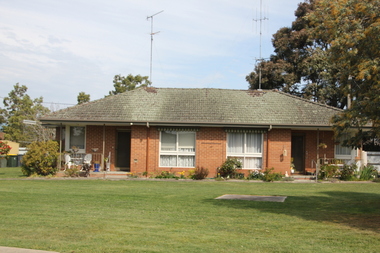
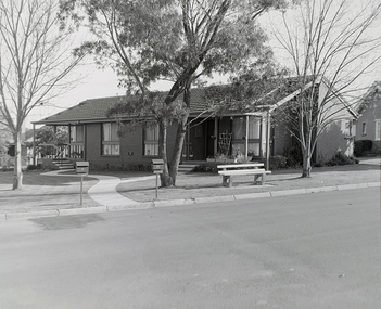
 Old Colonists' Association of Ballarat Inc.
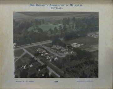
Photograph - Photograph - Colour, N.L. Harvey, Old Colonists' Association of Ballarat Cottages, 1958, 1958
Aerial Photograph of the Old Colonists' Association of Ballarat Cottages at Charles Anderson Grove. One of the first objectives of the Association was "to provide the shelter of a hose for those Pioneers of the Goldfields whom the reverses of fortune have deprived of the means of procuring the comforts of life in their declining years." The first home at Charles Anderson Grove was built in 1925. Before that time the Association provided relief for needy pioneers. relief included monthly monetary payments, loads of firewood, medical assistance and distribution of Christmas bosed of groceries to deserving pensioners, and in some cases payment of burial costs. ::a) The dominant purpose of the Association is to give public benevolent relief as a charity, but providing independent living accommodation in our Retirement Village for person in need who are over 65. ::b) To raise funds by membership subscription, commercial and residential rents, donations, gifts and voluntary work, for the purpose of providing direct relief of poverty, distress, misfortune or helplessness. ::c) To maintain the important heritage and ongoing viability of the Old Colonists' Association. (Revised Rules of the Old Colonists' Association of Ballarat Inc., 2016) old colonists' association, ballarat, charles anderson grove, retirement village -
 Old Colonists' Association of Ballarat Inc.
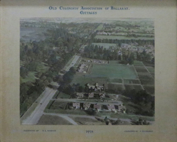
Photograph, Old Colonists' Association of Ballarat Cottages, 1958, 1958
Aerial photographs of the Old Colonists' Association of Ballarat Cottages at Charles Anderson Grove. One of the first objectives of the Association was "to provide the shelter of a hose for those Pioneers of the Goldfields whom the reverses of fortune have deprived of the means of procuring the comforts of life in their declining years." The first home at Charles Anderson Grove was built in 1925. Before that time the Association provided relief for needy pioneers. relief included monthly monetary payments, loads of firewood, medical assistance and distribution of Christmas bosed of groceries to deserving pensioners, and in some cases payment of burial costs. ::a) The dominant purpose of the Association is to give public benevolent relief as a charity, but providing independent living accommodation in our Retirement Village for person in need who are over 65. ::b) To raise funds by membership subscription, commercial and residential rents, donations, gifts and voluntary work, for the purpose of providing direct relief of poverty, distress, misfortune or helplessness. ::c) To maintain the important heritage and ongoing viability of the Old Colonists' Association. (Revised Rules of the Old Colonists' Association of Ballarat Inc., 2016) old colonists' association of ballarat, charles anderson grove, retirement village -
 Uniting Church Archives - Synod of Victoria
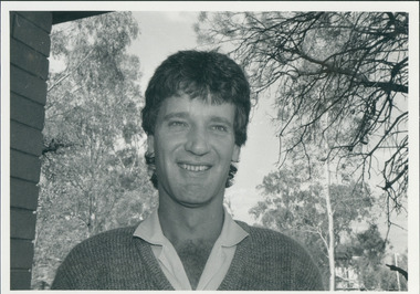
Photograph, St Philip's College Alice Springs - Principal Chris Tudor & Deputy Principal Chris Eldridge, 09/1986
In 1945 the Reverend Harry Griffiths, who worked for the Methodist Inland Mission in Alice Springs, saw the need for a boarding facility for children of families living in remote areas in Central Australia who needed access to schools. He and his wife established Griffiths House, on a site in the town centre, and for many years it became home for students from all over the Outback, including many young Aboriginal people. In the late 1950's the Rev Fred McKay, successor to the Rev John Flynn as Superintendent of the Australian Inland Mission, lobbied the United Church in the Northern Territory to build and expand on this important start. Together the Presbyterian, Methodist and Congregational churches embarked on a missionary venture to develop St Philip's College - a new, larger residential hostel which would one day become a full boarding school. An ideal site - 22 acres of bush at the junction of the Charles and Todd Rivers and backing on to the Telegraph Station National Park - was secured and after six years of planning, construction began in 1964. Fred McKay led the legendary work parties comprised of volunteers from all over Australia who travelled to Alice Springs, paying their own way and volunteering their expertise, time and labour, to turn a dream into a reality. This fantastic tradition continues today, with work parties arriving each mid-year holiday. On 13 February 1965 the first boarders moved in to St Philip's College. For the first 24 years, therefore, St Philip's College operated as a residential hostel only. The College’s ninth Headmaster, Mr Christopher Tudor, arrived in 1986. He and the Council Chairman, Mrs Jan Heaslip, judged that the time was right to complete the original plan to turn St Philip’s College into a fully fledged independent boarding/day school, serving not only “bush” families, but also the growing population of Alice Springs. The then College Council embraced the idea and three years of frantic, determined preparation and planning commenced, culminating in an extensive $2 million building program in 1988. To this day there continues to be further development with the new landscaping underway near The Minnamurra Hall, Reception and Rivergum Cafe, plus the recent completion of the Science & Food Technology building and the new Rivergum Cafe.Head & Shoulders of Chris Eldridgest. philip's college, tudor, chris, eldridge, chris -
 Uniting Church Archives - Synod of Victoria
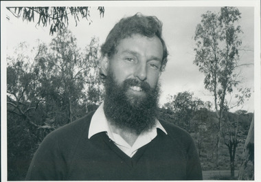
Photograph, St Philip's College Alice Springs - Principal Chris Tudor & Deputy Principal Chris Eldridge, 09/1986
In 1945 the Reverend Harry Griffiths, who worked for the Methodist Inland Mission in Alice Springs, saw the need for a boarding facility for children of families living in remote areas in Central Australia who needed access to schools. He and his wife established Griffiths House, on a site in the town centre, and for many years it became home for students from all over the Outback, including many young Aboriginal people. In the late 1950's the Rev Fred McKay, successor to the Rev John Flynn as Superintendent of the Australian Inland Mission, lobbied the United Church in the Northern Territory to build and expand on this important start. Together the Presbyterian, Methodist and Congregational churches embarked on a missionary venture to develop St Philip's College - a new, larger residential hostel which would one day become a full boarding school. An ideal site - 22 acres of bush at the junction of the Charles and Todd Rivers and backing on to the Telegraph Station National Park - was secured and after six years of planning, construction began in 1964. Fred McKay led the legendary work parties comprised of volunteers from all over Australia who travelled to Alice Springs, paying their own way and volunteering their expertise, time and labour, to turn a dream into a reality. This fantastic tradition continues today, with work parties arriving each mid-year holiday. On 13 February 1965 the first boarders moved in to St Philip's College. For the first 24 years, therefore, St Philip's College operated as a residential hostel only. The College’s ninth Headmaster, Mr Christopher Tudor, arrived in 1986. He and the Council Chairman, Mrs Jan Heaslip, judged that the time was right to complete the original plan to turn St Philip’s College into a fully fledged independent boarding/day school, serving not only “bush” families, but also the growing population of Alice Springs. The then College Council embraced the idea and three years of frantic, determined preparation and planning commenced, culminating in an extensive $2 million building program in 1988. To this day there continues to be further development with the new landscaping underway near The Minnamurra Hall, Reception and Rivergum Cafe, plus the recent completion of the Science & Food Technology building and the new Rivergum Cafe.Head & Shoulders of Chris Tudor.st. philip's college, tudor, chris, eldridge, chris -
 Uniting Church Archives - Synod of Victoria
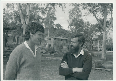
Photograph, St Philip's College Alice Springs - Principal Chris Tudor & Deputy Principal Chris Eldridge, 09/1986
In 1945 the Reverend Harry Griffiths, who worked for the Methodist Inland Mission in Alice Springs, saw the need for a boarding facility for children of families living in remote areas in Central Australia who needed access to schools. He and his wife established Griffiths House, on a site in the town centre, and for many years it became home for students from all over the Outback, including many young Aboriginal people. In the late 1950's the Rev Fred McKay, successor to the Rev John Flynn as Superintendent of the Australian Inland Mission, lobbied the United Church in the Northern Territory to build and expand on this important start. Together the Presbyterian, Methodist and Congregational churches embarked on a missionary venture to develop St Philip's College - a new, larger residential hostel which would one day become a full boarding school. An ideal site - 22 acres of bush at the junction of the Charles and Todd Rivers and backing on to the Telegraph Station National Park - was secured and after six years of planning, construction began in 1964. Fred McKay led the legendary work parties comprised of volunteers from all over Australia who travelled to Alice Springs, paying their own way and volunteering their expertise, time and labour, to turn a dream into a reality. This fantastic tradition continues today, with work parties arriving each mid-year holiday. On 13 February 1965 the first boarders moved in to St Philip's College. For the first 24 years, therefore, St Philip's College operated as a residential hostel only. The College’s ninth Headmaster, Mr Christopher Tudor, arrived in 1986. He and the Council Chairman, Mrs Jan Heaslip, judged that the time was right to complete the original plan to turn St Philip’s College into a fully fledged independent boarding/day school, serving not only “bush” families, but also the growing population of Alice Springs. The then College Council embraced the idea and three years of frantic, determined preparation and planning commenced, culminating in an extensive $2 million building program in 1988. To this day there continues to be further development with the new landscaping underway near The Minnamurra Hall, Reception and Rivergum Cafe, plus the recent completion of the Science & Food Technology building and the new Rivergum Cafe.Tudor and Eldridge in conversation with the College in the background.st. philip's college, tudor, chris, eldridge, chris -
 City of Moorabbin Historical Society (Operating the Box Cottage Museum)
Photograph - 115 Jasper Road, Bentleigh, Allan / Grewer Estate, c. 1890's
115 Jasper Road, Bentleigh East was a market garden owned by James Allan. In 1880 the property was transferred to David Grewar (Gruar) who had married James' niece Mary Allan. In 1926 part of the land was subdivided and sold as residential blocks. The block with the house pictured remained in the family until 1969. The land now forms part of Our Lady of Sacred Heart College. The description of the land owned by David Kidd Grewer (also spelt Gruar) in 1885: Fourteen acres or thereabouts at the corner of Jasper Road and Patterson’s Road East Brighton being part of Crown Block of 5720 acres Parish of Moorabbin County of Bourke being land comprised in Certificate of Title Volume 1344 Folio 268692 on which is erected a 4 roomed brick house with 2 rooms of wood at the rear and stable and a 2 roomed weatherboard cottage valued as under: 14 acres of land less crops £629.0.0 4 roomed brick house £250.0.0 Other buildings £50.0.0 2 roomed weatherboard cottage £35.0.0 Early pioneer family of the City of Moorabbin.Black and White photo in picture framegrewar, market garden, moorabbin, bentleigh, jasper road, housing, pioneer, james allan, orchard -
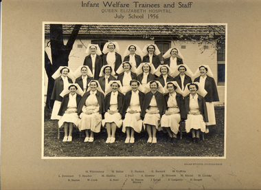 Kew Historical Society Inc
Photograph, Infant Welfare Trainees and Staff, Queen Elizabeth Hospital, 1956
Carlton Refuge/Carlton Home was established in 1857 in Madeline Street, Carlton (relocating in 1890 to Keppel Street, Carlton). The Carlton Home provided maternity care for married and unmarried mothers, and residential care for infants and toddlers unable to be at home with their mother. It also operated a day-care centre for children. Most of the residents were mothers or children on private placements. The Children's Welfare Department used the Carlton Home as a maternity home for wards, a foster home for infant wards, and for children requiring placements under the infant life protection provisions of the Children's Welfare Act. By the late 1940s, the home was in a bad state of repair and it closed in 1949. In 1951, the facility reopened as the Queen Elizabeth Maternal and Child Health Centre that also operated as an Infant Welfare and Mothercraft Training School. The Centre provided after-care for nursing mothers and babies transferring from maternity hospitals, and specialised care for babies referred by private practitioners and the Social Welfare Department – babies who were premature, frail or had feeding or similar problems. (Source: DHHS)The photograph is a valuable primary resource relating to training for maternal and infant welfare centres in Kew, Victoria. It has a strong provenance through inscriptions linking it to the Denmark Street Maternal and Child Health Centre.Photograph, mounted on card of Infant Welfare Trainees and Staff, Queen Elizabeth Hospital, 1956. The photograph lists the names of the individuals below the photograph. They include: Back Row {L-R] M Whittenbury, M Bolton, E Haebich, G Barnard, M Griffiths / Middle Row [L-R] L Stevenson, T Boucher, M Madden, J Price, A Glowrey, R Helmore, M Murfet, M Lindsay / Front Row [L-R] R Buxton, W Crick, G Stott, M Buxton Matron, J Keogh, B Longmuir, E Borgelt.Obverse: Infant Welfare Trainees and Staff, Queen Elizabeth Hospital, July School 1956 Reverse: "Presented to Kew Historical Soc by Dr Darbyshire following a 50 year birthday display at the Denmark Street Maternal and Child Health Centre [Kew] in May 1980. [Illegible]."denmark street maternal and child health centre, baby health centres --- kew (vic), queen elizabeth hospital, infant welfare -
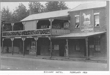 Wodonga & District Historical Society Inc
Photograph - Murray River "Railway" Hotel, Wodonga
Located in High Street, Wodonga, this hotel underwent many modifications and name changes. It was built c1859 by James Bambrick close to the intended rail terminal in Huon Street. The site of the rail terminal actually changed but the name remained. James Bambrick served three terms as Wodonga Council president and was it was commonly referred to as “Bambrick’s Hotel”. It included 30 rooms as well as dining facilities. James Bambrick ran the hotel until 1902 when it was sold to J. Donnelly for £3,000. In 1912, whilst operated by T. J. Weller, the residential section of the hotel was almost completely destroyed by fire but only the ceiling of the bar was damaged and it continued to operate. Over the ensuing years the licensee changed hands frequently. By 1952, John Perry, owner of the “Stump” Junction Hotel also had the freehold of the Railway Hotel At some stage in the mid 1980’s the hotel was renamed as the “Murray River Hotel”, but still displayed the sign of the Railway Hotel. In 2009, it was closed for a short time whilst renovations took place to convert it into O’Maille’s Irish Hotel. It was demolished in 2020. These images document changes to an important local building first established c1868. It was an important meeting place and also the location of the earliest Council meetings in Wodonga.A set of photos both black and white and colour depicting changes to the Railway Hotel, Wodonga over timeA variety of names and advertising signsjames bambrick wodonga, bambrick's hotel, railway hotel wodonga, murray river hotel wodonga, o'maille's hotel, -
 Department of Health and Human Services
Photograph, Berry Street Kindergarten
In 1877 the Victorian Infant Asylum was founded in Kew. In 1881, the asylum relocated to Berry Street in East Melbourne. By 1908, it was called the Foundling Hospital and Infants Home. It was non-denominational and controlled by a committee of management. By 1956, Berry Street consisted of a Mothercraft Training Centre and two main residential units: Berry Street for infants aged zero to 18 months, and Vale Street for toddlers aged zero to two years old. In August 1956, Berry Street was declared an approved category 2 Children's Home. In 1960, Vale Street was converted to an adult nursing home. In 1964, the name was changed to Berry Street Babies Home and Hospital. Berry Street was also an approved adoption agency. By 1968, Berry Street comprised the Training School for Mothercraft Nurses, the adoption agency, an infant life-protection house, a long-stay home for children to three years of age (the toddlers’ wing) and a small house for unmarried mothers. The home's infant life-protection work was seen as a critical agency function, particularly where family illness was putting pressure on mothers and Berry Street was able to provide respite and support. By the late 1960s, 30–40 adoptions annually were being arranged from Berry Street. By 1974 the home's orientation had shifted. Four family group homes had been established (two in Burwood, one in Ashburton and one in St Kilda), the mothercraft training function had been phased out, the toddlers wing converted to day care, and the main building (containing the nursery, administration, kitchen, dining room and single mothers accommodation) was demolished in favour of four home units, which housed 24 children, supervised by cottage parents. Berry Street provided short term, emergency and residential care for 'protection of infant' cases and state wards. Two flats were also established for short-term family accommodation. The nurses’ home was converted to house the home’s administration function and a social work service. The social work service coordinated family aid and family counselling services, and a neighbourhood house. In 1975 Berry Street also provided short-term care for 42 Vietnamese children brought to Australia in the official government-sponsored airlift. In 1976 Berry Street made application to change its category 2 Children's Home classification to category 1, as it was now catering for a wider range of children. It had ceased to be a babies’ home and hospital, and had started providing child and family care, including residential care. In 1977 Berry Street to established a family group home in Richmond to house children affected by the closure of St Cuthbert's Children's Home in Colac. Berry Street changed its name to Berry Street Child and Family Care in 1977. In 1978, the range of services provided by Berry Street Child and Family Care consisted of a social work counselling service, a financial aide, a family aide program using volunteers, two temporary accommodation units each housing eight children, an information and referral service, a neighbourhood house in Richmond, a day care centre for 36 children, and four family group homes. In 1980–81 the family group homes in Burwood were sold and the resources moved to the Richmond area. In 1994, Sutherland Youth and Family Services Inc. amalgamated into Berry Street Inc. During the 1990s, Berry Street combined with the Sutherland Community Resource Centre in Watsonia in Melbourne’s northern region. The agency operates today as Berry Street Victoria and has service centres across metropolitan and country Victoria. https://www.findingrecords.dhhs.vic.gov.au/CollectionResultsPage/BerryStreet -
 Eltham District Historical Society Inc
Document - Certificate of Title, Vol. 4930 Fol. 985900, Crown Portion 15 Section 5, Parish of Nillumbik, County of Evelyn, 1925
(Cancelled) Certificate of Title originally issued for Crown Portion 15, Section 5 to Robert David Taylor, of Eltham, County of Evelyn, Farmer, 13 March 1925. It is with this title that the land allotment was subdivided into 48 lots. The title shows the issuance to Robert David Taylor with encumbrance placed upon it by immediate former owner, Hugh Patrick Keogh, a former member for Gippsland and Melbourne Real Estate Agent. Following Taylor's death in 1934 the title passes to his Executors, sons Robert David Taylor of Bible Street, Eltham and William McLelland Vance Taylor of Northcote. The property is then sold to Frank Stokes who develops the Stokes Orchard. Compulsory acquisitions by the Melbourne Metropolitan Board of Works and State Electricity Commission show provisions of easemenst for town water supply and high voltage power transmission lines. Subsequent lots are then sold off with the development of the Stokes Orchard Estate residential development in the mid to late 1970s. A History of the Development of Crown Allotment 15, Section 5, Parish of Nillumbik – Stokes Orchard Crown Allotment 15, Section 5, Parish of Nillumbik (CA15) is a square allotment of 158 acres or approximately a quarter of a square mile. It lies just beyond the eastern end of Pitt Street, south of Nyora Road to the northern end of Eucalyptus Road and extends east from Eucalyptus Road to Reynolds Road. The topography of CA15 is generally steep, sloping up to a hill near the centre of the land, the ridgeline passing through the properties along the southern side of Diosma Road. Eucalyptus Road is a straight north-south road with its northern end at the north west corner of CA15. Until the end of the 1970s this road was an un-named Government Road and was largely not open to traffic. With residential development in the 1970s the road was constructed, and the council allocated the name obviously in recognition of the predominant species of the local bushland. CA15 was purchased from the Crown by George D’Arley Boursiquot, a prominent Melbourne printer, on 28th October 1852. On November 23, 1922, former Member for Gippsland and Melbourne Real Estate Agent, Hubert Patrick Keogh purchased the allotment then sold it March 13, 1925, to local farmer, Robert David Taylor, a former Shire of Eltham Councillor (1911-1920) and Shire President (1919). Taylor had extensive land holdings stretching west towards Bible Street and Main Road. The Taylor home was situated at the top of the hill in Bible Street at present day 82 Bible Street. At the time of Taylor’s purchase in 1925, CA15 was subdivided into 48 lots that could be described as small rural properties or large residential lots. A typical lot size was one hectare or 2.5 acres. The subdivision created two roads, Nyora Road, and Diosma Road, each following an irregular alignment between Eucalyptus and Reynolds Roads. However, the lots were not sold off separately nor were the roads constructed. The land effectively remained as one parcel for many further years. Robert David Taylor died November 30, 1934, and probate was granted to his son of the same name, Robert David Taylor of Bible Street, Salesman and William McLelland Vance Taylor of 73 Emmeline Street, Northcote, Clerk, with the transfer of the land into their names on July 8, 1935. Frank Stokes worked as a qualified accountant at Kennons leather factory in Burnley, while living at 1 Thomas Street, Mitcham. He suffered from migraines and wanted to return to working the land (he had previously worked on farms and orchards since coming to Australia from England in 1926, both in WA and Vic.). He first travelled to the district by train in July 1942 to find land with the intention to establish an orchard. By chance he met Arthur Bird of Bird Orchard (bounded by Pitt Street, Eucalyptus Road, and Wattle Grove) and they got talking over their common interest. Arthur put Frank up for the night and pointed out the land, 158 acres- part of the Taylor Estate- £900, Crown Allotment 15, Section 5, Parish of Nillumbik (CA15) somewhat diagonally opposite Bird Orchard. Stokes applied through the Riverina Agency to purchase the land who in turn applied for permission from Canberra to sell as there was a new government regulation introduced during the Second World War banning land sales except for immediate production. Stokes obtained a loan on his Mitcham house of £600 @ 5% and paid £450 deposit with quarterly payments of £15 spread over 5 years. Stokes was assisted and advised by Arthur Bird who farmed the neighbouring orchard. In early 1943 Stokes took possession and would catch the train out to Eltham on Fridays after work and began building a hut on the corner of Nyora Road and the Government Road (Eucalyptus Road) for shelter and to lock up tools. He established an orchard on the central western part of the land through the centre of which ran a natural waterway (part of the present-day linear park) and was able to pay a neighbour (Hawkins) to help with clearing and fencing 25 acres, and with a horse and single furrowed plough, planted approximately 2,500 fruit trees - cherries, peaches, plums, almonds, pears, apricots and lemons as well as a few apples and oranges; a massive task. Aerial photographs from the 1940s through to the 1990s clearly show the orchard with most of the larger CA15 site remaining as natural bushland. A huge problem was hares and rabbits eating all the new buds off the tiny trees. As well as laying poison he painted the trees with a mixture of cow manure and lime, often working by moonlight. Procurement of wire and wire netting was difficult because of the war but after much effort he obtained a permit from the Agricultural Department for supplies in March 1944. In February 1945 Stokes applied for a permit to build a “packing shed” as no house building was allowed. It was to be 33 feet x 21 feet and cost £312. It was constructed mostly from second-hand materials, which were hard to obtain, especially iron for roofing. Stokes finished work at Kennons on October 31, 1945, and in March 1946 he sold the family home at Mitcham for £1,230 plus £170 for furniture. On May 15, 1946, title to the CA15 property was issued to Frank Howard Alfred Stokes, Orchardist and Gladys Ethel Stokes, Married Woman, both of Pitt Street, Eltham. The family of five then moved into the very unfinished “packing shed” at Eltham, which was a struggle to weatherproof. Eventually rooms were divided off and lined with hessian bags and whitewashed. Their income was firewood (cut and sold), selling rockery stones and cut Sweet Bursaria. (It was discovered during the 1940s that Sweet Bursaria contained the sunscreen compound Aesculin. The RAAF utilised this compound from Sweet Bursaria during WW2 for pilots and gunners.) The orchard’s first fruit sale was a half-case of Le Vanq peaches in December 1947 for the price of 8 shillings. In 1956 plans for house were drawn and Glen Iris bricks purchased (1956 Olympic Rings variant). The building of the house commenced in 1957 - 12 feet of original packing shed was removed – and was completed in 1959. Water was connected from newly built pressure storage on the property at the end of 1959 and the electricity connection for the first time at 3pm on April 29, 1960. The house remains to present day (somewhat modified) at 1 Nyora Road, home to Nyora Studio Gallery. On occasions, spare remnants of the 1956 bricks have been known to be unearthed in gardens on the estate as they were utilised by Frank Stokes to fill in rabbit holes. On May 26, 1950, a parcel of land was compulsorily acquired by the Melbourne and Metropolitan Board of Works on the hilltop to establish an easement for a high-level service reservoir to augment Eltham’s water supply. The project also included pipe tracks for the necessary water mains. The reservoir has now been superseded by higher level water tanks east of Reynolds Road and its former site is now a public reserve. On November 27, 1964, the State Electricity Commission served notice to compulsorily acquire a further parcel through the eastern part of the land for a major electricity transmission line that augmented supply from the La Trobe Valley to Melbourne. The easement was registered February 11, 1966. The easement was widened July 18, 1969 for a second transmission line to be constructed. In 1971 Melbourne Metropolitan Planning Scheme amendments adopted Nyora Road as the boundary between a residential zone to the north and a rural zone to the south. This determined the future development of the land. In the mid-1970s the Shire of Eltham divided the orchard into numerous rate-able parcel lots, the 48 lots having been established in 1925 and the subsequent rates assessment proved unsustainable for Stokes. He commenced selling lots outside the boundary of the orchard, north of Diosma and South of Nyora. However shortly later the land between Nyora and Diosma Roads and west of the electricity easement was sold and subdivided into residential lots, a housing development by Macquarie Builders and marketed as the Stokes Orchard Estate. New streets were created, and most were named after trees, although one, Stokes Place, commemorates the former owners. The development was undertaken in two stages; Stage 1 (1975) encompassing Scarlet Ash Court, Ironbark Close and Peppermint Grove bounded by Nyora and Eucalyptus roads and Stage 2 (1978) encompassing Stokes Place, Orchard Way, The Crest and The Lookout bound by Nyora and Diosma roads. The developer, Macquarie Builders went bankrupt shortly after the release of Stage 2 leaving many purchasers to fend for themselves and arrange for their own independent builders. There were also difficulties with sewerage for the land immediately south of Diosma Road and so the conventional residential lots were abandoned in favour of larger lots. The development of Orchard Way, The Crest and The Lookout did not proceed as planned and the proposed lots were incorporated into five-acre parcels instead. These included a low-density group housing development by the Graves family and the award winning Choong House (1983) with Gordon Ford developed garden immediately next door situated on the ridge of the hill nestled amongst the original bush, Eucalypt trees and Sweet Bursaria. In 1994, Nillumbik Shire Council applied Significant Environment and Significant Landscape overlays upon the properties on the south side of Diosma Road to ensure protection of this natural bush garden environment. With the arrival of the sewer along Diosma Road in the 1990s, most of these five-acre parcels have since been subdivided multiple times. The Choong house presently sits on a 2.7-acre property, which in 2022 Nillumbik Council nominated for Cultural Significance Heritage protection and is considered potentially significant at State level. The Stokes family were also associated with the Eltham Christian Church. In the 1970s this church had met in temporary premises in Eltham. Lots of the original 1925 subdivision remained south of Nyora Road and a number of these lots were utilized for the Eltham Christian School, which was established by the Eltham Christian Church in 1981. The school operated on this site until 2000. The premises are now used by The Vine Baptist Church. By the mid-1980s the whole of CA15 had been developed for residential and school purposes, except for the sections north of Diosma Road and between the transmission lines and Reynolds Road. Sewerage issues had been resolved for the section north of Diosma Road and in 1987 it was in the process of being subdivided into residential lots. The development coincided with the discovery of colonies of the rare and endangered Eltham Copper Butterfly on the site. This resulted in a community and political campaign to save the butterfly habitat. With the co-operation of the land developer the subdivision was altered to create two bushland reserves in the critical butterfly habitat areas. In the late 1980s the State Government was investigating options for establishing a metropolitan ring road link between Diamond Creek and Ringwood. The chosen route was adjacent to Reynolds Road and so this created a freeze on development of CA15 between Reynolds Road and the electricity easement. The ring road proposal was eventually abandoned, and this part of the land was subdivided into low density residential lots. Diosma Road has been discontinued at the electricity easement and the eastern part incorporated into View Mount Court with access from Reynolds Road. The whole of CA15 has now been developed for residential or associated purposes, ranging from conventional density to quite low density south of Nyora Road. Some remnants of the orchard remain, a few cherry trees on the Graves property and a lone apple tree in Stokes Place. The butterfly reserves comprise significant areas of remnant bushland. Linear reserves through the estate link with central Eltham via the Woodridge linear reserve and with Research along the electricity easement. CA15 as it exists today has a complicated history of rural use, Government acquisition, urban development, and community action. References: • “Stokes Orchard, an incomplete history”; Russell Yeoman with Doug Orford • Correspondence, Beryl Bradbury (nee Stokes) • Aerial Photographs, 1931-1991, Landata (landata.vic.gov.au) • Certificate of Title, Vol. 4930 Fol. 985900 • Plan Number LP 10859 neil webster collection, diosma road, eltham copper butterfly, eucalyptus road, ironbark close, nyora road, peppermint grove, power transmission lines, reynolds road, scarlet ash court, stokes orchard estate, stokes place, woodridge estate, frank stokes, certificate of title -
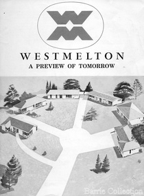 Melton City Libraries
Document, West Melton: A preview of tomorrow, c.1969
"In April 1969, the first major residential development in Melton began with the release of 148 homes for purchase. This was the first stage of a staggered release of a planned 30,000 homes for 100,000 people by 1990. The development, called Westmelton Satellite City, was described as ‘a preview of tomorrow’.101 It was the first estate built in a ‘modern’ style, with curved streets, and dozens of culs de sac. Westmelton was also the first major development in Victoria to build all the supply lines to the houses – including electricity and telephone lines – underground. The six different home designs in Westmelton were ‘specially designed for the future’, and with allotments ten feet wider than regulations required, there was plenty of ‘space for gracious living’ and for a family swimming pool. The developers of this new estate were active in promoting Westmelton as a new community within the Shire of Melton. By 1971, the Westmelton City News reported that Ian McIntosh, General Manager of Westmelton, had given away $100,000 on behalf of the company ‘to aid community projects’. This included a $72,000 donation towards building a community centre in Westmelton, and $25,000 for the shire’s Olympic-sized swimming pool. Ian McIntosh and his family moved to Melton and Ian said he was ‘very much aware of the needs of [the] Westmelton community’. By the end of 1971, Westmelton was home to 100 new families. The modern residences were obviously an appealing drawcard, but so was the country feel that characterised Melton. Mrs C. Allen, described as a ‘housewife’, said she and her husband chose to move to Westmelton because of ‘the quality homes ... and we both love the clean, fresh, natural environment that surrounds us’. Similarly, Mr W. Coxhead, insurance consultant, moved to Westmelton because of the ‘clean, fresh country air’. Accountant Mr B. Swanton echoed their sentiments, describing Westmelton as ‘far enough away from the industrial pollution carried over Melbourne suburbs by prevailing westerly winds’. The new development attracted an increasing number of young, professional couples and families, representing the beginning of a significant shift from the predominantly rural and farming community of the district’s past. The Westmelton development had four different ‘neighbourhoods’ designed to cater to a variety of different lifestyle needs. Westmelton was the first to be established, followed by Brookfield, which offered ‘superb land in a rustic setting’. Brookfield Acres offered ‘wide open spaces with lots of room for a pool and even a tennis court’ on huge one-acre blocks, while Westlake was an innovative development with ‘different sized homesites’ and ‘lakeside living’.Westmelton was the first of many residential developments that would come to play a huge role in shaping the shire in the decades to follow".A marketing brochure for the Westmelton Satellite City developmentlocal significant events, council -
 Federation University Historical Collection
Book, The Work of Dwight James Baum, 1927 (exact)
Dwight James Baum is an American architect. He was born in 1886 in Newville, New York. As a young man, Baum moved to Syracuse. In 1909, he graduated from Syracuse University with an architecture degree. He worked for Boring and Tilton and Sanford White which are well known Architecture firms in America. Around 1912, he started his own residential design firm. During the 1920s, Baum designed a significant buildings and several houses in Sarasota, Tampa, Terrace, Temple and Florida all in the Mediterranean Revival Style such as the Ringlings dubbed Cà d'Zan, which is now known as the John and Mable Ringling Museum of Art. In 1923-1924, he also designed Sunset Hill for Mrs. Eugene D. Stocker at Warren, New York which was listed on the National Register of Historic Places in 2007. During the Depression Baum became involved with Good Housekeeping Magazine as consulting architect, and as designer of their building exhibit at the 1933 Chicago World's Fair. His later work includes Hendricks Memorial Chapel at Syracuse University, with John Russell Pope in 1929–1930 and the pedestal for V. Renzo Baldi's statue of Columbus in the city's Columbus Circle. Dwight James Baum died in 1939. Book with large blue hard cover. Title is written on the front cover and the spine in gold. Manufacturer's logo is written on front cover in gold. The book includes index, preface and an introduction. black and white illustrations, plates and floor planes of the architect's work such as Ca d Zan, the fantastical Venetian Gothic waterfront palace of John and Mable Ringling in Sarasota, Florida and the stately Italianate house of Anthony Campagna in Riverdale, New York and more.architecture, architectural designs, art moderne, domestic designs, ca d zan -
 Eltham District Historical Society Inc
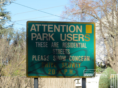
Photograph, Heritage Excursion; Eltham Lower Park Walk and Talk, 1 July 2017, 1 July 2017
Street signage: Attention park users these are residential streets please show concern drive slowly 20 m.p.h with graffiti Newsletter No., 234, June 2017 Heritage Excursion - Saturday 1st July - Eltham Lower Park - Walk and Talk Eltham Lower Park has played an important part in the history of our area since the early days of European settlement when it was used by local residents as an informal racecourse. Prior to that its location at the junction of the Diamond Creek and the Yarra River made it an important meeting place for the Wurundjeri people. The park combines formal elements and sporting facilities with remnant bushland that is of environmental significance. It is home to sporting and horse riding clubs, popular play spaces and the Diamond Valley Miniature Railway, which attracts large numbers of visitors. The park will be the venue for our July excursion which will comprise a walk of about 3.5 km around the park and adjacent areas. Along the way we will discuss the history and natural history of the area. The path along the creek and the river provides a pleasant and scenic walk. This walk on Saturday 1st July is about 3.5 km in length and will take 2 to 2.5 hours. It will start at 2pm at the Main Road car park at the front of the park. (Melway ref 21 H 10). Born Digitalheritage excursion, activities, eltham district historical society, eltham lower park, sign, grafitti -
 Melbourne Tram Museum
Photograph - Digital Image, series of three images of the Hawthorn Bridge over the Yarra, c1930, c1930's
Image from CD (Compact Diskette for use in computers) - see Reg Item 135. A series of three images of the Hawthorn Bridge over the Yarra, c1930, during the era with problems with the bridge. See separate article for more details. Richmond 6, Richmond, Richmond 3 on the CD as original files. .1 - Looking from the south west, at the Hawthorn bridge with the temporary wooden bridge being constructed on the south side. Has the cable tram depot in the photo and part of the Burnley racing course. Temporary track on the north side of the steel bridge and crossings can be seen. .2 - Looking along Bridge Road to the east with Hawthorn Bridge in the middle of the photograph. Shows the industrial and residential areas, Hawthorn Railway Station and part of the Burnley Race course, the cable tram depot building. W class tram in Church St Hawthorn and W class tram crossing the bridge on the north side temporary track. Note the cable tram used as a shelter on the north east corner of the bridge. .3 - Looking south along River St towards Bridge Road, with the Yarra River and Hawthorn Bridge on the left side of the photograph. Shows the industry in the area at the time, wool and skin Merchants, north side of the cable depot, housing and the outlook to the river!trams, tramways, hawthorn, yarra river, burnley, richmond, hawthorn bridge -
 University of Melbourne, Burnley Campus Archives
Plan, 36 Railway Ave, Armadale, 1991-1997
Sets of plans for a Residential Garden produced by students for an assignment. (1) Tracing paper and paper copies site plan sketch. (2) Janine Bugg - Assessment Preliminary Plan, Concept Plan, Site Inventory and Analysis, Site Elevation A, Section Elevation B dated 26.05.1994. (3) Carmen Skrobonja - Assessment Main Plan & Section Elevation, Concept Plan dated 31.05.1991. (4) G. Mutimer - Preliminary Plan, Section Elevation, May 1994. (5) Melissa King - Assessment, Site Inventory & Analysis, Site Concept Plan, Preliminary Main Plan, Section Elevation, May 1997. (6) Jim Despotellis - Site Inventory & Analysis, Concept Plan, Preliminary landscape Design, 25.04.1994 - 15.05.1995. (Also see B11.0775.) (7) 33 Railway Ave (sic), Colour photographs pasted on paper. (8) Marli Draper - Site Inventory and Analysis, Concept Plan, Preliminary Plan, Perspective Feature Bed. (Also see B11.0773). (9) Cowan (Creations) - Site Inventory and Analysis, Concept Plan, Preliminary Plan, Assessment, 30.05.1994. (10) McRae (Designs) - Site Inventory and Analysis, Preliminary Main Plan, Concept Plan, Section View to Tussock Grass and Eucalyptus, 30.05.1997 - 01.06.1997. (11) Leah Syme - Site Inventory and Analysis.armadale, janine bugg, carmen skrobonja, melissa king, jim despotellis, marli draper, leah syme, g. mutimer, students, assignments