Showing 3893 items matching "east st"
-
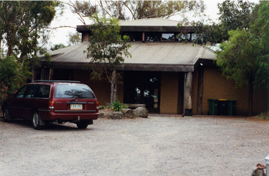 Eltham District Historical Society Inc
Photograph, Margaret Ball, St Margaret's mudbrick hall, 83 Pitt Street, Eltham, c. June 1999, 1999
The Margaret Ball (Pre 1960s Houses) Collection was a personal project initiated to mark the year 2000 and arose as a result of the disappearance of many pre-1960s parts of Eltham due to development. Approximately 200 pre-1960s style houses that were left in Eltham between Main Road and east to Bible Street, between Cecil Street to the north and south to Dalton Street were photographed in late 1999. Not all of the houses could be photographed; some because the garden or trees blocked the view of the house, others because of rubbish or cars were in the way, some because people were working on the house or in the gardens at the time.Colour photographic print eltham, houses, streets, margaret ball (pre 1960s houses) collection, pitt street, st margaret's anglican church -
 Eltham District Historical Society Inc
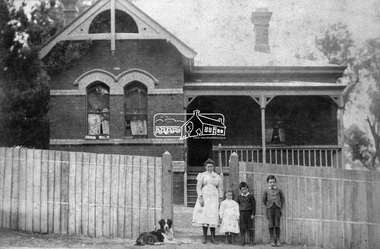
Negative - Photograph, Wall Bros, State School Residence, Dalton Street, Eltham, c.1902
Shows Mrs J. Brown, one of her four daughtrers and her two sons who died in World War One with their dog posing in front of fence of Headmaster's house, at Eltham State School, Dalton Street. Date circa 1902. The building still stands. Reproduced p66 of Pioneers & Painters Mrs Jane Elizabeth Brown (nee Staines) and three children of her large family who left the Headmaster's residence when John Brown (Headmaster 1889-1906) died (on the job) in 1906. John and Jane had ten children eight girls and two boys. Their two sons both died in the 1914-1918 War; George Stewart Brown (1885-1916) and John Leonard Brown (1887-1918). The young girl may be Elsie Maria Brown (1889-1917) which would date the photo around 1902. Wall Bros operated at St Kilda from around 1889 to 1903. John Brown died 23 Sept 1906 after a short severe illness at age 55 and is buried in Box Hill Cemetery (Evelyn Observer 28 Sep 1906 p2). The book "We did open a school in Little Eltham" incorrectly states his date of death as 16/12/1906. Title The Evelyn Observer. (1906, September 28). Evelyn Observer and Bourke East Record (Vic. : 1902 - 1917), p. 2 (MORNING.) Url http://nla.gov.au/nla.news-article61129880 Description It is with sincere regret we record the death of Mr. John Brown, State school teacher, Eltham, which sad event took place at his residence, "Pine Brae," on Sunday night last, 23rd inst. after a severe illness of some few weeks' duration. The deceased gentleman was highly respected, and always took a lively and active interest in promoting the progress and prosperity of the district, and his loss will be much felt, He was only 55 years of age, and leaves a wife and large family to mourn their loss, and much sympathy is felt for them. The remains of the deceased were interred in the Box Hill cemetery on Wednesday afternoon last. This photo forms part of a collection of photographs gathered by the Shire of Eltham for their centenary project book,"Pioneers and Painters: 100 years of the Shire of Eltham" by Alan Marshall (1971). The collection of over 500 images is held in partnership between Eltham District Historical Society and Yarra Plenty Regional Library (Eltham Library) and is now formally known as 'The Shire of Eltham Pioneers Photograph Collection.' It is significant in being the first community sourced collection representing the places and people of the Shire's first one hundred years.Digital image 4 x 5 inch B&W Neg Sepia photo B&W printSepia photo reverse: Miss Tonkinson Used Pioneers and Painters p66 Could be Miss Brown and part of her family who left the Headmaster's residence when John Brown (Headmaster 1889-1906) died (on the job) in 1906. Then 2 sons both died in the 1914-1918 War Between 1888 and prior to 1906. Also Wall Bros. St Kilda stamp B&W print: 66 and 9 7/16" x 5 5/8" deep (for publication on p66 of Pioneers & Painters)sepp, shire of eltham pioneers photograph collection, state school residence, eltham state school, state school no. 209, dalton street, eltham primary school, teacher residence, eltham, headmaster, houses, main road, pioneers and painters, school, school residence, schools, george stewart brown (1885-1916), elsie maria brown (1889-1917), john leonard brown (1887-1918), jane elizabeth brown (nee staines) -
 Eltham District Historical Society Inc
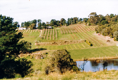
Photograph, Between Kangaroo Ground and Panton Hill looking east from near Flat Rock Road towards Kangaroo Ground-St Andrews Road, 1995, 1995
Colour photographflat rock road, kangaroo ground, kangaroo ground-st andrews road -
 Eltham District Historical Society Inc
Photograph, Murchison Gap, Autumn Excursion, Hume and Hovell's 1824 expedition, 26 May 1996, 26/05/1996
[article by Bettina Woodburn in EDHS Newsletter No. 109, July 1996:] ON THE TRAIL OF HUME AND HOVELL - REPORT ON THE AUTUMN EXCURSION - On a green and fresh morning (Sunday 26th May 1996) the Cobb and Co coach (driven by the most obliging Peter Tampion) set off in a north easterly direction from Eltham to connect with Hume and Hovell's route on their 1824 explorations of central Victoria. The Society would follow a series of monuments erected for the 1924 centenary of the expedition from King Parrot Creek (Tuesday 7th December 1824), through Strath Creek, over Sunday Creek (Sunday 12th December 1824) at Broadford, Tullamarine, St Albans, Deer Park, through Werribee, skirting east of the You Yangs to Lara and Avalon Beach. Because their distance-measuring wheel had broken and a one degree mistake was made in calculations, the two leaders of the original group of six convict-companions arrived at Corio Bay, instead of the expected Western Port, discovered earlier by Flinders. From below Mt. Disappointment (Hume and Hovell's difficulties in "scrambling over brush and rock", "leeches in forest, as well as no water", "cutting grass 4-5 ft. high", dreadful scrub", "devil flies") we took an easier route, saw the Strath Creek memorial in ground fog and a wonderful "field of dreams", the Hume-Hovell privately owned cricket ground with its white picket boundary fence. Now, after a steep climb, in sunshine under gums we stretched and viewed magnificent rolling hills and fog-filled valleys - not "smoke from Aborigines' bush fires". After morning tea at Broadford we followed the Sunday Creek valley beside the Hume Freeway, passed the Wallan Wallan Rest Area (more appropriately Hume and Hovell Rest Area) to tum right at Beveridge. In Gellibrand Hill Park, near the headwaters of the Moonee Ponds Creek, we experienced the landscape the first European settlers saw - huge river red gums and rolling pastures. The gardens and sheltered courtyard of the 1840s, timber, brought from .....[?] prefabricated Woodlands Homestead, provided a pleasant lunch stop. We enjoyed a private tour, panoramic views over Melbourne and surroundings and the excitement of arriving and departing aircraft. Our next river crossing was at Werribee, "in a vast treeless plain", then we drove on by-ways no coach had previously travelled, to find "an immense sheet of water" salty Corio Bay, off-course to the west. In late afternoon of a super, calm, late autumn day we headed homewards. Back at Eltham we were rather surprised to find that we had travelled a total of 347 km. Thanks again to Russell Yeoman for his research and organization. What a wonderful day! Three colour photographsactivities, murchison gap, murchison valley -
 Eltham District Historical Society Inc
Photograph, Hume and Hovell Monument, Broadford, Autumn Excursion, Hume and Hovell's 1824 expedition, 26 May 1996, 26/05/1996
[article by Bettina Woodburn in EDHS Newsletter No. 109, July 1996:] ON THE TRAIL OF HUME AND HOVELL - REPORT ON THE AUTUMN EXCURSION - On a green and fresh morning (Sunday 26th May 1996) the Cobb and Co coach (driven by the most obliging Peter Tampion) set off in a north easterly direction from Eltham to connect with Hume and Hovell's route on their 1824 explorations of central Victoria. The Society would follow a series of monuments erected for the 1924 centenary of the expedition from King Parrot Creek (Tuesday 7th December 1824), through Strath Creek, over Sunday Creek (Sunday 12th December 1824) at Broadford, Tullamarine, St Albans, Deer Park, through Werribee, skirting east of the You Yangs to Lara and Avalon Beach. Because their distance-measuring wheel had broken and a one degree mistake was made in calculations, the two leaders of the original group of six convict-companions arrived at Corio Bay, instead of the expected Western Port, discovered earlier by Flinders. From below Mt. Disappointment (Hume and Hovell's difficulties in "scrambling over brush and rock", "leeches in forest, as well as no water", "cutting grass 4-5 ft. high", dreadful scrub", "devil flies") we took an easier route, saw the Strath Creek memorial in ground fog and a wonderful "field of dreams", the Hume-Hovell privately owned cricket ground with its white picket boundary fence. Now, after a steep climb, in sunshine under gums we stretched and viewed magnificent rolling hills and fog-filled valleys - not "smoke from Aborigines' bush fires". After morning tea at Broadford we followed the Sunday Creek valley beside the Hume Freeway, passed the Wallan Wallan Rest Area (more appropriately Hume and Hovell Rest Area) to tum right at Beveridge. In Gellibrand Hill Park, near the headwaters of the Moonee Ponds Creek, we experienced the landscape the first European settlers saw - huge river red gums and rolling pastures. The gardens and sheltered courtyard of the 1840s, timber, brought from .....[?] prefabricated Woodlands Homestead, provided a pleasant lunch stop. We enjoyed a private tour, panoramic views over Melbourne and surroundings and the excitement of arriving and departing aircraft. Our next river crossing was at Werribee, "in a vast treeless plain", then we drove on by-ways no coach had previously travelled, to find "an immense sheet of water" salty Corio Bay, off-course to the west. In late afternoon of a super, calm, late autumn day we headed homewards. Back at Eltham we were rather surprised to find that we had travelled a total of 347 km. Thanks again to Russell Yeoman for his research and organization. What a wonderful day! Colour photographactivities, broadford, hume and hovell, monument -
 Eltham District Historical Society Inc
Photograph, Hume and Hovell Monument, Autumn Excursion, Hume and Hovell's 1824 expedition, 26 May 1996, 26/05/1996
[article by Bettina Woodburn in EDHS Newsletter No. 109, July 1996:] ON THE TRAIL OF HUME AND HOVELL - REPORT ON THE AUTUMN EXCURSION - On a green and fresh morning (Sunday 26th May 1996) the Cobb and Co coach (driven by the most obliging Peter Tampion) set off in a north easterly direction from Eltham to connect with Hume and Hovell's route on their 1824 explorations of central Victoria. The Society would follow a series of monuments erected for the 1924 centenary of the expedition from King Parrot Creek (Tuesday 7th December 1824), through Strath Creek, over Sunday Creek (Sunday 12th December 1824) at Broadford, Tullamarine, St Albans, Deer Park, through Werribee, skirting east of the You Yangs to Lara and Avalon Beach. Because their distance-measuring wheel had broken and a one degree mistake was made in calculations, the two leaders of the original group of six convict-companions arrived at Corio Bay, instead of the expected Western Port, discovered earlier by Flinders. From below Mt. Disappointment (Hume and Hovell's difficulties in "scrambling over brush and rock", "leeches in forest, as well as no water", "cutting grass 4-5 ft. high", dreadful scrub", "devil flies") we took an easier route, saw the Strath Creek memorial in ground fog and a wonderful "field of dreams", the Hume-Hovell privately owned cricket ground with its white picket boundary fence. Now, after a steep climb, in sunshine under gums we stretched and viewed magnificent rolling hills and fog-filled valleys - not "smoke from Aborigines' bush fires". After morning tea at Broadford we followed the Sunday Creek valley beside the Hume Freeway, passed the Wallan Wallan Rest Area (more appropriately Hume and Hovell Rest Area) to tum right at Beveridge. In Gellibrand Hill Park, near the headwaters of the Moonee Ponds Creek, we experienced the landscape the first European settlers saw - huge river red gums and rolling pastures. The gardens and sheltered courtyard of the 1840s, timber, brought from .....[?] prefabricated Woodlands Homestead, provided a pleasant lunch stop. We enjoyed a private tour, panoramic views over Melbourne and surroundings and the excitement of arriving and departing aircraft. Our next river crossing was at Werribee, "in a vast treeless plain", then we drove on by-ways no coach had previously travelled, to find "an immense sheet of water" salty Corio Bay, off-course to the west. In late afternoon of a super, calm, late autumn day we headed homewards. Back at Eltham we were rather surprised to find that we had travelled a total of 347 km. Thanks again to Russell Yeoman for his research and organization. What a wonderful day! Two colour photographsactivities, hume and hovell, monument -
 Ringwood and District Historical Society
Audio - Recording - Vinyl, Recorded at S.D.A. Academy, Lilydale, by Bob Clarke, Choir of St Stephens, Ringwood East. Vinyl Record with printed insert. 1975, Aug-75
... Choir of St Stephens, Ringwood East. Vinyl Record with... with text. 'Produced by the choir of St Stephens, Ringwood East... of St Stephens, Ringwood East.' There is a printed insert. Choir ...Vinyl record 12 inch 33 1/3 rpm, two - sided, stereo. Held in white sleeve and plastic pocket. Yellow label at the centre with text. 'Produced by the choir of St Stephens, Ringwood East.' There is a printed insert. -
Ringwood and District Historical Society
Document - Handout, Ringwood Garden Club, Handout for the Beautiful Gardens of Ringwood Competition, 19th and 20th September, 1987, 1987
Handout for the Beautiful Gardens of Ringwood Competition, 19th and 20th September, 1987.Foolscap typed sheet.BEAUTIFUL GARDENS OF RINGWOOD COMPETITION. 19th. & 20th. September, 1987. The Committee of the Ringwood Garden Club would like to extend a very warm welcome to all who have joined us on today's tour. We hope you enjoy the best six of the winning gardens from the 16 entries we received. Signs in the winning gardens indicate what prizes have been awarded as well as on your programme. After the tour, we hope you will join in Afternoon Tea, kindly prepared by the ladies of our Committee. Following afternoon tea, the coaches will return to Eastland Carpark. 1st. Stop: Section 4: Individual Garden in Home Units or Flats. 1st. Prize: Mr. & Mrs.C. & B. Harris, Unit 6, 32 Wilana St., Ringwood. 2nd. Prize: Mr. & Mrs. W. & T. Wilson, Unit 5, 32 Wilana St., Ringwood. 2nd. Stop: Section 3: Home Garden - Viewed from the Street. 1st. Prize: Mr. L. Sperling, 4 Lorienne Rd., Heathmont. 3rd. Stop: Section 1: Home Garden, Street Frontage exceeding 65 ft. (20 m) 2nd. Prize: Mr. K. Clark, 42 Bronhill Rd., Ringwood East. 4th. Stop: Section 3: Home Garden - Front Only. 2nd. Prize: Mr. H. Smit, 21 Unsworth Rd., Ringwood. 5th. Stop: Section 2: Home Garden, Street Frontage not exceeding 65 ft. (20 m.) 6th. Stop: Section 1: Home Garden - Street Frontage exceeding 65 ft. (20 m) 1st Prize: Mr. B. Wheatley, 57 Oliver St., Ringwood. 7th. Stop: Afternoon Tea at the Ringwood Senior Citzens Clubrooms, Greenwood Ave., Ringwood. 8th. Stop: Eastland Carpark. We hope you have enjoyed our tour this afternoon and hope you will visit our Club's Spring Flower and Floral Art Show, which will be staged on Saturday 10th, & Sunday 11th. of October in the Ringwood Uniting Church Hall, Cnr. Station St. & Greenwood Ave., Ringwood. The show will be open on Saturday from 2.00 p.m. till 5.30 and on Sunday from 1.00 till 4.30 p.m. Entry is $1.00. Schedules and all Show information are available from the Show Secretary, Clive Manly on 873-2264. Prize Winners for the Garden Competition will receive their Certificates at the Show at the Official Opening by the Mayor of Ringwood at 3.00 p.m. on Saturday. Our show will feature displays of Cut Flowers & Shrubs, Plants in Containers, Floral Art, Cookery and Children's sections. Our Plant Stall will be operating during the days of the show and an excellent afternoon tea is available. COME TO THE SHOW AND BRING A FRIEND. OOOoooOOOoooOOO -
Ringwood and District Historical Society
Document - Handout, Ringwood Garden Club, Handout of the Beautiful Gardens of Ringwood Competition, 19th and 20th September, 1987, 1987
Handout of the Beautiful Gardens of Ringwood Competition, 19th and 20th September, 1987.Foolscap typed sheet.BEAUTIFUL GARDENS OF RINGWOOD COMPETITION. 19th. & 20th. September, 1987. The following is a list of the Prize-Winning Gardens in this years Garden Competition. A total of 16 gardens were submitted for judging. Points awarded by the judge are in brackets and are given from a maximum of 100. Section 1: Home Garden - Street Frontage Exceeding 65 ft.(20 m.) 1st: Mr. B. Wheatley, 57 Oliver Street, Ringwood.(86) 2nd: Mr. K. Clark, 42 Bronhill Rd., Ringwood East.(67) 3rd: Mr. A. Blank, 28 Panorama Rd., Ringwood. (44) Section 2: Home Garden - Street Frontage Not Exceeding 65 ft. (20 m.) 1st. Mr. G. Williams, 69 Evelyn Rd., Ringwood.(73) 2nd. D. & P. Smithson, 7 Pamela Court, Nth. Ringwood. (72) 3rd. Mrs. D. Kane, 16 Lynwood Ave., Ringwood East.(65) Section 3: Home Garden - Front Only. Area that can be viewed from the Street. 1st: Mr. L. Sperling, 4 Lorienne Rd., Heathmont.(67) 2nd. Mr. H. Smit, 21 Unsworth Rd., Ringwood.(63) 3rd. Mr. & Mrs. G. Schmad, 8 Lyn Crt., Ringwood.(53) Section 4: Individual Garden in a Group of Flats or Home Units. (may include rear garden) 1st: Mr. & Mrs. C. & B. Harris, Unit 6, 32 Wilana St. Ringwood.(72) 2nd: Mr. & Mrs. W.C. & T. Wilson, Unit 5, 32 Wilana St., Ringwood. (49) Section 5: Garden in Non-Residential Property. There were no entries in this section. The Ringwood Garden Competition is sponsored by the Ringwood City Council and organised by the Ringwood Garden Club. The President and Committee of the Ringwood Garden Club would like to thank all home gardeners of Ringwood who entered this year's competition and hope they will enter again next year. If you would like to know more about the activities of our Club, come along to our meetings, which are held on the FOURTH MONDAY of each month, in the Ringwood Senior Citizens Clubrooms, Greenwood Ave., Ringwood commencing at 8.00 p.m. A warm welcome will be made to all visitors to our meetings. ____________________________________________ ___________________________________________ __________________________________________ _________________________________________ ________________________________________ -
 Ringwood and District Historical Society
Photograph-B&W, Joan Walker, East Ringwood 2000-Pedestrian crossing (near Lois St) looking towards the Station, 2000
East Ringwood 2000-Pedestrian crossing (near Lois St) looking towards the Station- B&W Photo from Album 6501 -
Ringwood and District Historical Society
Envelope, Packet: Ringwood Area Hotels - Coach and Horses, Empress India, Burnt Bridge. Also Antimony Mine Hotel Proclaimed 1878
Hotels list; Coach and Horses Hotel; Club Hotel Sept-1887 Wiggin sold to Lindsey; Empress India Hotel; Antimony Mine Hotel, East Ringwood, Cnr Main & Pratt St proclaimed 21-Jan-1878 owing to increase in mining population, 4 licences in locality; Burnt Bridge Hotel; "Duke of York" -
 Ringwood and District Historical Society
Document - Book draft, History of St Stephens Uniting Church, Freeman Street, Ringwood East, Vic. May 1955 to October 2003, Feb-07
Handwritten draft - History of St Stephens Uniting Church, Freeman Street, Ringwood East, Vic. May 1955 to October 2003, compiled from minute books and church records by Keith Sutton, February 2007. -
 Ringwood and District Historical Society
Photograph, Looking east across Staley Gardens from Market Street Ringwood - 1982
... , "8.4.82. Looking east across Staley Gardens from Market St ...Written on back of photograph, "8.4.82. Looking east across Staley Gardens from Market St. at the old Charter St. corner." -
 Ringwood and District Historical Society
Photograph, Ringwood Reserve, East Corner, Looking south to the "Mail" office, mid 1960's
4 copies of same photograph with various inscriptionsTyped below one photograph, "Ringwood Reserve, 1963. Looking south Rusty Roof is "Ringwood Mail". 1966. Another has "Ringwood Oval Looking South. Rusty Roof is "Mail"Office in Adelaide St. Area No Eastland. 1965 on reverse. Another two have dates of 1962. -
 Ringwood and District Historical Society
Photograph, Foundation stone for Ringwood State School No. 2997, laid by Mrs. J.K. Turnbull on 15th August, 1889
Photograph of Foundation stone for Ringwood State School No. 2997 was laid by Mrs. J.K. Turnbull on 15th August, 1889, marking the opening of the school situated in Whitehorse Road at the corner of Ringwood Street (1889-1922). Mrs. Turnbull was the wife of the Ringwood Station Master. The stone was removed after the school closed in 1922 and re-laid in 1962 by the School Committee at this subsequent Greenwood Avenue school site and is pictured here being viewed near the entrance in 1973 by Mr. Ron Pullin, Archivist, Ringwood Historical Research Group".Sign below photograph reads, "Foundation stone of Ringwood State School (late Ringwood St.). Now in grounds of Greenwood Avenue Ringwood State School". Inscription on stone, "This foundation stone was laid by Mrs. J.K. Turnbull on 15th August 1889". Printed on plaque below stone, "No.2997 - Ringwood State School 1889-1922. Situated in Ringwood Street, East Side sixty yards north of Maroondah Highway. Foundation stone removed 19?? re-erected by the School Committee 1962". -
Ringwood and District Historical Society
Envelope, Packet: St Francis de Sales School, East Ringwood. 1958 Opening
St. Francis de Sales newspaper cutting account of opening -
 Ringwood and District Historical Society
Photograph, Building old Ringwood swimming pool, 1934, Ringwood St
... , 1934, Ringwood St.", looking Sth East.... Ringwood swimming pool, 1934, Ringwood St.", looking Sth East ...Black and white photograph See Item 3000 for newspaper articles with 1934 datesTyped below image, "Building old Ringwood swimming pool, 1934, Ringwood St.", looking Sth East. -
 Ringwood and District Historical Society
Photograph, Boundary Photo across Dandenong Ck towards Ringwood (H E Parker Reserve). 1979
Written on back of photograph, "Jan. 79 - boundary photo. Looking across Dandenong Creek towards Ringwood (H.E. Parker Reserve) - ?? South East corner of Ringwood. From children's playground end of Derwent (?) St." -
 Orbost & District Historical Society
black and white photograph/ poscards, Vogt. W.S, C1890 - 1920
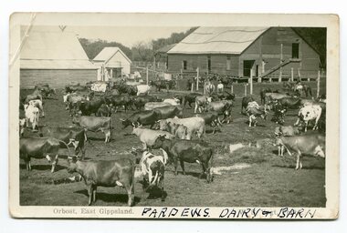
Edward James Pardew died in 26/9/1927 aged 92. He came to Orbost from New Zealand in 1886 and selected 720 acres of hill land in the Brodribb area. He was a member of the first Orbost Shire Council. His daughter had a fruit & meat shop in McLeod Street. He was an inaugural vestryman of St James Church of England. One of the most prominent farmers on the Snowy was John Gilbert, a large landowner. His breeding establishment was at Tullagoota, about two and a half kilometres down the river from Orbost.Dairying in the Orbost district was once a mainstay of the farming community. Today the properties are fewer and smaller.Two black / white photographs of dairy herds. 3188.1 - on front - printed -"ORBOST EAST GIPPSLAND"; hand-written - :PARDEWS DAIRY & BARN" 3188.2 - on front - printed - " W. S. VOGT"; hand-written - "DAIRY HERD TALLAGOOTA< ORBOST"dairying-orbost agriculture-orbost pardew-dairy tallagoota-dairy -
 Orbost & District Historical Society
black and white photographs, 1980s? (winter months)
All photographs seem to have been takenfrom the Telecom tower on the corner of Browning and Wolseley Streets in Orbost 3259.1 is a view of the Orbost township looking north-east. The swimming pool and bowling club can be seen in the foreground. 3259.2 is aview looking north-west and showing the tennis courts and clubhouse, the Recreation Reserve oval, the Youth Centre, Historical Museum, Municipal Offices, Senior Citizens clubrooms with the fire station in the foreground. 3259.3 is a view looking south with the Shire of Orbost Municipal offices and Ruskin Street in the foreground. Munro Street can be seen running from Ruskin Street to St Joseph's School in the middle distance. Lochiel Park oval, Lochiel House, the Snowy River and highway bridge are in the background. 3259.4 is a view looking south showing the Club Hotel, C.B.C. Bank in the middle distance and Hoffman's paddock (Forest Park) and the Snowy River beyond. 3259.5 is a view looking north-east over houses. 3259.6 is aview over the main street, Nicholson Street.showing the main shopping precinct. Shop signs for Permewans, Williams Shoes, F.B. Dicken and Orbost Bakery can be seen. 3259.7 is a view looking south west and shows Forest park and beyond towards Bete Bolong.These photographs are detailed pictorial records of the township of Orbost.Seven black / white photographs taken from above a township. Chimney smoke can be seen in the photographs.orbost-township-1980s aerial-photograph-orbost -
 Orbost & District Historical Society
black and white photographs, second half 20th century
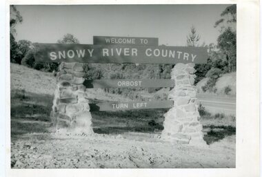
These photographs are pictorial records of the signs at the Orbost town entry points.Three black / white photographs. 3277.1 is a sign on stone pillars at the top of a hill - "WELCOME TO SNOWY RIVER COUNTRY ORBOST TURN LEFT". 3277.2 shows a road leading into a town. There is a sign on the left - "ORBOST" and a service station on the right. 3277.3 shows a row of newly planted trees between a road and a school.3277.1 on back - "WELCOME TO SNOWY RIVER COUNTRY - ORBOST sign - Princes Highway - Newmerella" 3277.2 on back - "East Gippsland Shire Sign on eastern approach to ORBOST., in Salisbury Street, near Orbost Secondary College" 3277.3 on back - "Tree planting in Salisbury St, Orbost in front of Orbost High School looking west towards Orbost township"photographs-orbost orbost-township-entry salisbury-street-trees town-entry road-signs-orbost -
 Ringwood and District Historical Society
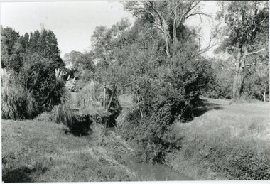
Photograph, Mullum Mullum Creek- 29-10-89
Black and white photograph"Written on back of photograph" Mullum Mullum Creek Looking East (upstream) North Bank near Harrison St -
 Ringwood and District Historical Society
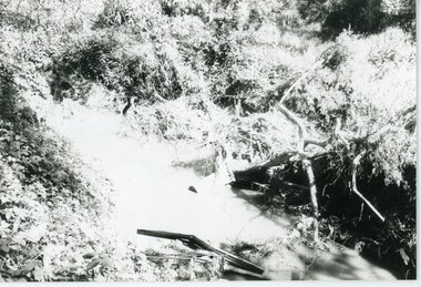
Photograph, Mullum Mullum Creek- 29-10-89
Black and white photograph"Written on back of photograph" Mullum Mullum Creek North bank West of Harrison St Rubbish and weeds - view generally to the East -
 Ringwood and District Historical Society
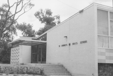
Photograph, St Francis De Sales School, Ringwood East
One photograph has, 'RWD E' written on back. -
 Ringwood and District Historical Society
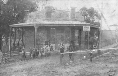
Photograph, Maroondah Highway East, Ringwood- 1914. Mr. O.J. Pratt's butcher shop under construction, cnr Main Street and Warrandyte Road
Black and white photograph (2 copies)Typed below photograph: "Mr. O.J. Pratt's butcher shop being constructed corner Warrandyte Rd. and Main St. (Demolished for road widening) 1914. Site became C.B.C. Bank. -
 Ringwood and District Historical Society
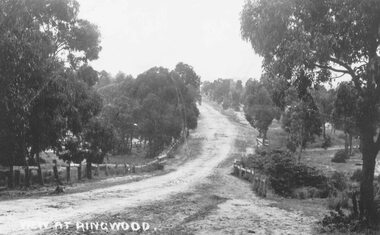
Photograph, Maroondah Highway East, Ringwood- 1870. Sandy Creek, now Ringwood Lake
... below large photograph: "Main St looking east. Right hand side... at Ringwood" Typed below large photograph: "Main St looking east ...3 photographs (2 large black and white, 2 small- 1 black and white, 1 sepia) Written on all photographs, "View at Ringwood" Typed below large photograph: "Main St looking east. Right hand side of gully now Ringwood Lake. Written on back of sepia print: "1870, Sandy Creek now Ringwood Lake" -
 Ringwood and District Historical Society
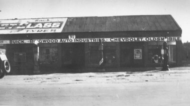
Photograph, Maroondah Highway East, Ringwood- c.1930's. H. F. Richards' Garage, cnr Whitehorse Road and Pratt Street
Black and white photograph (2 copies)Written on rear of backing sheet: "H. J. Richards garage - corner Whitehorse Rd. and Pratt St. Ringwood." -
 Ringwood and District Historical Society
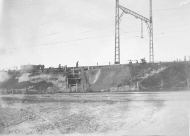
Photograph, Maroondah Highway East, Ringwood- 1923. Start of Warrandyte Road railway bridge construction
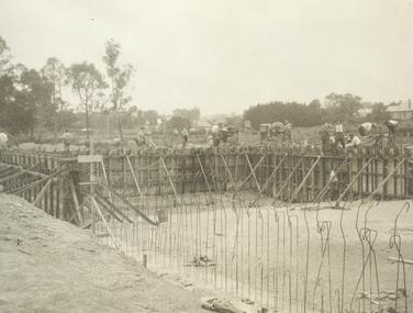
Black and white photograph (3 copies- 2 large, 1 small sepia)Typed below large photograph: "Building Warrandyte Rd. subway 1923. Taken from Maroondah Highway." Written on rear of backing sheet: "Start of Pitt St. viaduct." -
 Ringwood and District Historical Society
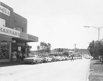
Photograph, Maroondah Highway Central, Ringwood. Rear of shops in Maroondah Hwy east of Adelaide Street- 1963
Black and white photograph (3 copies- 2 large, 1 small)Typed below large photograph: "Rear of shops in Maroondah Highway. Taken from Adelaide St. near Warrandyte Rd. 1963". Written on back of another copy: "Rear of shops in Maroondah Highway east of Adelaide Street. Shed on right is in Adelaide St opposite 'Mail' office." -
 Ringwood and District Historical Society
Photograph, Maroondah Highway Central, Ringwood. Easterly view towards Warrandyte Road intersection- 1974
... Written on backing sheet, "Main St. looking east... St. looking east to Warrandyte Rd. 1974". Black and white ...Black and white photographWritten on backing sheet, "Main St. looking east to Warrandyte Rd. 1974".