Showing 11484 items matching "maps "
-
 Victorian Aboriginal Corporation for Languages
Book, Marilyn Gray, Flora of Melbourne : a guide to the indigenous plants of the greater Melbourne area, 2001
Comprehensive book giving illustration of plants and very specific, detailed descriptions.Colour photographs, illustrations, mapsindigenous plants, werribee river, mount evelyn, sunbury, mount eliza, botany, plant associations, park regeneration, propagation, weeds -
 Victorian Aboriginal Corporation for Languages
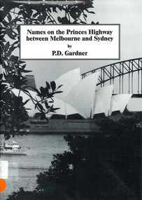
Book, P D Gardner, Names on the Princes Highway between Melbourne and Sydney : their origins, meanings and history, 2000
Place name list in a specific area. Giving descriptions and meanings.Maps, b&w illustrationsdandenong, genoa, south coast nsw, yarra river, moruya, kiama, captain cook, east gippsland, rosedale -
 Victorian Aboriginal Corporation for Languages
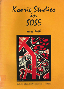
Book, Catholic Education Commission of Victoria, Koorie studies in SOSE : years 7-10, 2001
Section 1. Notes on the use of this resource Section 2. Policy support statements. Aboriginal Studies Policy Statement of Victorian Aboriginal Education Association Incorporated (VAEAI) National Principles and Guidelines for Aboriginal Studies and Torres Strait Islander Studies, K-12 Principles for the Introduction of Aboriginal Perspectives in the Curriculum of the Catholic School (Catholic Education Commission of Victoria Policy 1.3, 1987) Section 3. Language, culture and viewpoint: issues of terminology Section 4. Units of work Unit 1. Koorie people of south-east Australia: a contemporary view Unit 2. On sacred ground Unit 3. Koorie life in the pre-contact era Unit 4. Mulla Meea-Baa Gnuenjall: a long time ago, and today Unit 5. The land we share: human stories in the environment Unit 6. Frontier wars Unit 7. Aboriginal mission stations and reserves in Victoria Unit 8. Land, law and indigenous Australians Section 5. Directory of indigenous organisations and affiliated groups/?agencies. National organisations Victorian organisations Catholic Education Commission of Victoria Indigenous Education personnel Organisations within regions of the Archdiocese of Melbourne Organisations within regions of the Ballarat Diocese Organisations within regions of the Sale Diocese Organisations within regions of the Sandhurst Diocese Cultural centres/?camps across Victoria.maps, b&w photographsvaeai, history, curriculum development, koorie studies, catholic education commission of victoria, secondary school education, -
 Victorian Aboriginal Corporation for Languages
Book, Aboriginal Resource and Development Services, Cross cultural awareness education for Aboriginal people : a consultancy for the Office of Aboriginal Development, 1994
Includes - Section A: Legal & Economic Research Section B: Comments on the current siruation in the two selected communities Section C: Outline of the Education Model Section D: New Understanding - The Process Section E. Indicators for Assessment - Short and Long Section F: Recommendations for the program and its expansion.Maps, b&w illustrationsnorthern territory, arnhem land, multicultural education -
 Rutherglen Historical Society
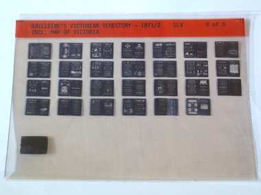
Microfiche, Bailliere's Victorian Directory 1871/2, 1871/72
A directory in Victoriasmall sheet of film SLV Incl. Map Of Victoriatown, names, victoria, map -
 Old School House Museum
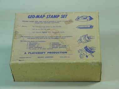
Rubber Stamp Set
Used by teachers for teaching geography, they would take the plate and attach to the handle, stamp it into ink and would make multiple copies for the students to either identify capital and countries or to learn the shape and localities of each locationIt was an early way of making multiple copies for teaching students.Geography stamp set in box which include 4 plates and handle. Plates include, Asia,Africa,Victoria,The world Geo-Map Stamp Setfrankston primary school, rubber stamps, education, geo-map, victoria, asia, the world, africa, playcraft production -
 Bendigo Historical Society Inc.
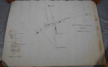
Administrative record - South Frederick The Great Mine, Sebastian, Mine map
Draftsman's drawing of South Frederick The Great Mine, Sebastian. Forms part of the Margaret Roberts Collection of mining records.Pencil markings additions to mapbendigo, margaret roberts, gold, map, south frederick the great mine -
 Melton City Libraries
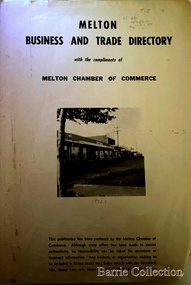
Booklet, Melton Business and Trade Directory, c.1965
BUSINESS TRADE AND DIRECTORY MAP NORTH of High Street RALIEGHS Road - Early settlers Oliver Reierson ( Norwegian) Raliegh SHEBLER Court Auguste EMIL Court Jongebloed Family residence “Hemlich” ALEXANDRA Street Coronation King, Queen Alexandra - 1903 O’NEILS Road Farmer OLDERSHAW Road CORR Grove Early landowner, Teacher at the Common School – Denominational Churches, 1850’s Wesleyan (Methodist) BRYAN Court 1850’s resident renamed from earliest town site - Flat HURLEY Street Early settler and farmers - CHESNEY Road was named Minns, due to duplication altered to Chesney (Minns) SOUTH of High ALKEMADE Drive. Family name ARNOLD Court Family BARRIES Road Charles Ernest Barrie “Darlingsford” 1911 Residence KILPATRICKS Road became Barries Road west of Station Road BLACKWOOD Drive Alexander, Early settler CALLANAN Drive Surveyor early LUBY Court John Luby - Crown Grant Land title KERWIN Street Michael - Crown Grant land title (deleted due to Freeway)Pamphlet of Melton Businesses and map of the townlocal identities, misc., council -
 Federation University Historical Collection
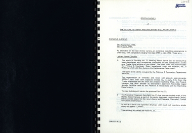
Report, SMB: Review Survey of Buildings and Grounds, July 1985, 1985
... maps ...Report of the detailed review of The School of Mines and Industries Ballarat Limited undertaken by Alexander & Alexander in 1985. Previous reports were done in 1982 and 1983. The report covers all areas of the school - buildings and grounds. Some sections/buildings are still being completed. Report contains written evaluation, maps/diagrams and photographs.Spiral bound book - dark blue cover. 15 pages of written information plus 3 pages of photographs.Gold lettering on from cover "Alexander & Alexander" Signature "J W Elliott" on page 10 (Loss Control Surveyorballarat school of mines and industries, survey, alexander and alexander, j w elliott, maps, photographs -
 Kew Historical Society Inc
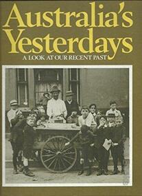
Book, Cyril Pearl, Australia's Yesterdays: a look at our recent past, 1974
Cyril Pearl provided historical guidance and contributed much of the textSydney : Readers Digest Services Pty Ltd, 1974 360 p. : ill.(some col.), facsims., maps, ports. ; 31 cm. non-fictionCyril Pearl provided historical guidance and contributed much of the textaustralia -- social conditions -- 20th century, australia -- social life and customs -- 20th century, australia -- biography., australia -- social conditions 1901-1970 -
 Greensborough Historical Society
Map, Melbourne and Metropolitan Board of Works. Survey Division, MMBW, Yarra 2500 / 11.22. Bundoora, 1979_01
Melbourne and Metropolitan Board of Works. Yarra 2500 [base map] 11-22. Bundoora. Parish of Keelbundoora 2856, Municipalities of Diamond Valley 257 and Whittlesea 239. Prominent streets include: Greenhills Road, Cabernet Crescent and Plenty Road. Includes Parade College (Christian Brothers) and "proposed future freeway" (now Metropolitan Ring Road)MMBW Map in 1:2500 [scale] series. Cream parchment with green tape reinforcing on edges and punched holes on left edge.mmbw, melbourne and metropolitan board of works, shire of diamond valley, bundoora - maps -
 Greensborough Historical Society
Map, Melbourne and Metropolitan Board of Works. Survey Division, MMBW, Yarra 2500 / 15.21. Eltham North, 1979_08
Melbourne and Metropolitan Board of Works. Yarra 2500 [base map] 15.21. Eltham North. Parish of Nillumbik 3310. Municipalities of Diamond Valley 257 and Eltham 238. Prominent streets include: Progress Road, Glen Park Road and Zig Zag Road. Features include the Diamond Creek, Eltham Council Pound and Eltham North Reserve.MMBW Map in 1:2500 [scale] series. Cream parchment with green tape reinforcing on edges and punched holes on left edge.mmbw, melbourne and metropolitan board of works, shire of diamond valley, nillumbik, eltham - maps -
 Greensborough Historical Society
Map, Melbourne and Metropolitan Board of Works. Survey Division, MMBW, Yarra 2500 / 14.23. Diamond Creek, Sutherland Homes, 1979_05
Melbourne and Metropolitan Board of Works. Yarra 2500 [base map] 14.23. Diamond Creek, Sutherland Homes. Parish of Morang 3183 and Nillumbik 3310. Municipality of Diamond Valley 257. Prominent streets Aqueduct Road, Diamond Creek Road, Yan Yean Road and McLaughlans Lane. Features include the abandoned Maroondah aqueduct and Sutherland Cottages.MMBW Map in 1:2500 [scale] series. Cream parchment with green tape reinforcing on edges and punched holes on left edge.mmbw, melbourne and metropolitan board of works, shire of diamond valley, plenty - maps, sutherland homes, maroondah aqueduct -
 Greensborough Historical Society
Map, Melbourne and Metropolitan Board of Works. Survey Division, MMBW, Yarra 2500 / 13.28. Mernda, Wilton Vale, 1977_08
Melbourne and Metropolitan Board of Works. Yarra 2500 [base map] 13.28. Mernda, Wilton Vale. Municipality of Diamond Valley 257 and Whittlesea 239. Prominent streets: Wilton Vale Road. Features include Yan Yean Pipe Track and SEC Transmission Lines. The abandoned rail line (old Whittlesea line) is in the top left corner.MMBW Map in 1:2500 [scale] series. Cream parchment with green tape reinforcing on edges and punched holes on left edge.mmbw, melbourne and metropolitan board of works, shire of diamond valley, mernda - maps -
 Greensborough Historical Society
Map, Melbourne and Metropolitan Board of Works. Survey Division, MMBW, Yarra 2500 / 15.24. Diamond Creek, Grassy Flat Road, 1978_02
Melbourne and Metropolitan Board of Works. Yarra 2500 [base map] 15.24. Diamond Creek, Grassy Flat Road. Parish of Nillumbik 3310. Municipality of Diamond Valley 257. Prominent streets include: Everleigh Drive, Broad Gully Road and Clyde Street. Features include the Diamond Creek, Nillumbik Park and Diamond Creek Reservoir.MMBW Map in 1:2500 [scale] series. Cream parchment with green tape reinforcing on edges and punched holes on left edge.mmbw, melbourne and metropolitan board of works, diamond creek - maps, shire of diamond valley -
 Kiewa Valley Historical Society
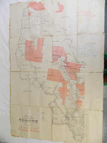
Map - Kiewa Valley, County Map of Bogong, 27/11/1905
This map has been owned by the Ryder Family of the Kiewa Valley for possibly over 100 years (1905?). It was used when the family mustered and maintained cattle on their grazing lease on the Bogong High Plains. Obviously a field map used on these occasions.This map was used by the Ryder Family who lived in the Kiewa Valley and who grazed cattle on their lease on the Bogong High Plains during summer.Showing reserves Under the Forest Act of 1907. This is a paper map which has been mounted or glued on pink and cream floral cotton. It is obvious by its poor condition that it has been used outdoors in the field. It is not in very good condition as it has been folded 4 times (8 divisions) and it is badly worn and cracked in the creases.Photo Lithographed at the Department of Lands and Surveys by T.E.McGauran 27/11/05 Price 1/3d. Scale - 2 miles to an inch. F.S. Hilcke Oct. 2nd 1905.department of lands and surveys map; ryder family; bogong high plains -
 Ballarat Heritage Services
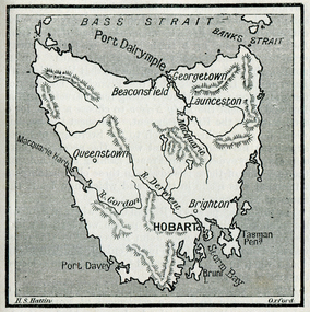
Photograph - Map, Hobart and Port Dalrymple
... maps ...Copy of a map from 'A Short History of Australia' by Ernest Scott.map, explorers, exploration, bass straight, hobart, port davey, georgetown, beaconsfield, queenstown, gordon rover, derwent river, launceston, port dalrymple, banks straight, macquarie harbour, maps, plans -
 Wodonga & District Historical Society Inc
Map - Hamilton-Smith Collection Hand Drawn Map of Wodonga c. 1938
The Hamilton-Smith collection was donated by the children of Grace Mary Hamilton-Smith nee Ellwood (1911-2004) and John Hamilton-Smith (1909-1984) who settled in Wodonga in the 1940s. The Ellwood family had lived in north-east Victoria since the late 1800s. Grace’s mother, Rosina Ellwood nee Smale, was the first teacher at Baranduda in 1888, and a foundation member of the C.W.A. Rosina and her husband Mark retired to Wodonga in 1934. Grace and John married at St. David’s Church, Albury in 1941. John was a grazier, and actively involved in Agricultural Societies. The collection contains significant items which reflect the local history of Wodonga, including handmade needlework, books, photographs, a wedding dress, maps, and material relating to the world wars. This item is unique, handmade and has a known owner. It forms part of a significant and representative historical collection which reflects the local history of Wodonga. It contributes to our understanding of social and family life in early twentieth century Wodonga, as well as providing interpretative capacity for themes including local history and social history.A map hand drawn in black pen on thick beige paper. map, subdivison, development, wodonga, local history, hamilton-smith, hamilton-smith collection -
 Port Melbourne Historical & Preservation Society
Map - Large map of Port Melbourne with Japanese annotation, British Chart, Port Melbourne, c 1937
Jim Sinclair was born in Cruickshank Street, Port Melbourne in 1924. During World War II Jim found this Japanese map in a network of caves near Rabaul, Papua New Guinea. He remembers '"The Japanese had linked just about every hill with a tunnel. Concreted. Most of them were packed with stuff. I used to wander through - being very careful too, mind you!. You didn't want yourself to get blown up. I found these maps. I thought that looks familiar! It's in English with Japanese stuff on it too."A large 1937 British map of Port Melbourne with Japanese printed annotations with strategic infrastructure marked. Used during World War II. Stamp on back explains age in Japanese. war - world war ii, port of melbourne, jim sinclair, japanese -
 National Vietnam Veterans Museum (NVVM)
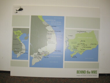
Poster - Poster, Information Board, Behind The Wire
... Maps ...Storybord with three maps of Vietnam showing various locations of importance such as Saigon, Nui Dat, Vung Tau, Binh Ba, Long Tan, FSB Horseshoe, An Nhut, Baria, Hoa Long and Xuyen Moc.storyboard, behind the wire, maps, saigon, nui dat, vung tau, long tan -
Whitehorse Historical Society Inc.
Document, Particulars of maintainance works, 1933
... Maps ...Shire of Blackburn and Mitcham - particulars of maintenance works carried out under the maintenance grant for the year ending 30 Jun 1933 and map showing work on the Main Healesville Road and Main Burwood Road.Shire of Blackburn and Mitcham - particulars of maintenance works carried out under the maintenance grant for the year ending 30 Jun 1933 and map showing work on the Main Healesville Road and Main Burwood Road.Shire of Blackburn and Mitcham - particulars of maintenance works carried out under the maintenance grant for the year ending 30 Jun 1933 and map showing work on the Main Healesville Road and Main Burwood Road.local government, shire of blackburn and mitcham, financial documents, maps, burwood road, healesville road, whitehorse road -
Whitehorse Historical Society Inc.
Map, Parish of Nunawading, 1853
... Maps ...Photocopy of manuscript map with allotments numbered and named.Photocopy of manuscript map with allotments numbered and named. Note on verso: Parish of Nunawading, County of Bourke. Gardiners Creek, Ballyshanassey Township, surveyed by H. Parmein, Surveyor General's office, Nov 30th 1853 [enlargement of ND2801, no list of corner references]Photocopy of manuscript map with allotments numbered and named. maps, gardiners creek, ballyshanassy, burwood east, parmein, h -
 Greensborough Historical Society
Map, Melbourne and Metropolitan Board of Works. Survey Division, MMBW, Yarra 2500 / 13.19. Lower Plenty, Montmorency, Yallambie, 1979_02
Melbourne and Metropolitan Board of Works. Yarra 2500 [base map] 13-19. Lower Plenty, Montmorency, Yallambie. Parishes of Keelbundora 2856 and Nillumbik 3310. Municipalities of Heidelberg 228, Diamond Valley 257 and Eltham 238. Prominent streets include: Elder Street, Para Road, and Main Road Lower Plenty. Includes Watsonia Army Barracks.MMBW Map in 1:2500 [scale] series. Cream parchment with green tape reinforcing on edges and punched holes on left edge.mmbw, melbourne and metropolitan board of works, shire of diamond valley, montmorency - maps, yallambie - maps, lower plenty - maps -
 Melbourne Tram Museum
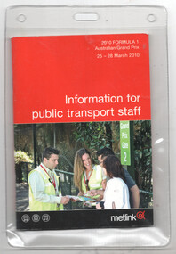
Booklet, Metlink, "Information for public transport staff - 2010 Formula 1 Australian Grand Prix", 2010
Booklet titled "Information for public transport staff - 2010 Formula 1 Australian Grand Prix". Gives details of event for train, tram, and bus crews, event program, and transport map, including shunting details, announcements, bus replacement services, electric or automatic points, and route alterations. The back cover has contact telephone numbers and web addresses.Yields information about the 2010 Grand Prix and how tram crews were provided with information.Forty page full colour publication or booklet plus covers with fold out map on the rear, within a clear plastic envelope.trams, tramways, grand prix, metlink, formula 1, albert park -
 Surrey Hills Historical Society Collection
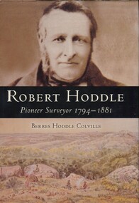
Book, Robert Hoddle: pioneer surveyor 1794-1881, 2004
(Ms) Berres Hoddle Colville is a local Surrey Hills resident and is a descendant of Robert Hoddle. Robert Hoddle was the first Surveyor General of Victoria. He arrived in Australia in 1823 and was one of the very earliest surveyors to explore, measure and map large areas of this vast, varied and difficult countryside, in a burgeoning era of pastoral settlement. 1837 saw him appointed Surveyor in Charge of the Port Phillip District. This book is based firmly on substantial extracts from Hoddle's own diary and other writings. Includes black and white sketches, maps and colour pages.Robert Hoddle was the first Surveyor General of Victoria. He arrived in Australia in 1823 and was one of the very earliest surveyors to explore, measure and map large areas of this vast, varied and difficult countryside, in a burgeoning era of pastoral settlement. 1837 saw him appointed Surveyor in Charge of the Port Phillip District. This book is based firmly on substantial extracts from Hoddle's own diary and other writings. Includes black and white sketches, maps and colour pages.Front endpaper: SURREY HILLS HISTORICAL / SOCIETY / PURCHASED FROM / THE AUTHOR ON THE OCCASION / OF HER TALK ON ROBERT HODDLE / TO THIS SOCIETY ON 17-10-[20]05 Title page: signed by the author: Berres Hoddle Colville / 17 October 2005 /(mr) robert hoddle, surveyors, (ms) berres hoddle colville -
![Governing the Metropolis: politics, technology and social change in a Victorian city - Melbourne, 1850-1891 / [by] David Dunstan](/media/collectors/550653872162f11fb04854aa/items/5ed0413cdcf9cd08346b6448/item-media/5ed04231dcf9cd08346b66f5/item-fit-380x285.jpg) Kew Historical Society Inc
Kew Historical Society IncBook, Melbourne University Press, Governing the Metropolis: politics, technology and social change in a Victorian city - Melbourne, 1850-1891, 1984
Carlton, Vic. : Melbourne University Press, 1984 xvii, 362 p., [14] p. of plates : ill., facsims., maps, ports. ; 24 cm. non-fictionmelbourne metropolitan area (vic) -- politics and government -- 1851-1891., urbanization -- victoria -- melbourne. -
 Bendigo Military Museum
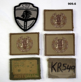
Uniform - ARM PATCHES, c.2001-2016
Items related to Shai NOKES Australian Army colour patches .1) CTU Combined Team Uruzgan patch. Black & white featuring a lion's head & motto, shield shaped. .2), .3) & .4) Unit insignia patches. Khaki rectangle with embroidered logo centred in wreath in cream, gold & brown. .5) Australia flag patch KR 549. Green & gold central map of Australia. All above have over sewn edges. .6) KR549. Khaki rectangle with handwriting..1) Motto: “Courage Unity Teamwork” .5) Embroidered under map: “AUSTRALIA” .6) Handwritten in texta: KR549 uniforms - army, badges, patches -
Ringwood and District Historical Society
Report, Ringwood Bypass and Suda-Larissa Avenue pedestrian crossing reports. 1992, 14-Jul-92
Brief notes and a locality map issued to local householders about a meeting to discuss the Suda-Larissa Avenue pedestrian crossing.Brief notes and a locality map issued to local householders about a meeting to discuss the Suda-Larissa Avenue pedestrian crossing. Report comprising three white A4 pages: two with typed notes and one of Ringwood Bypass notes. +Additional Keywords: Adams, Chris -
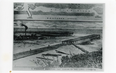 Lakes Entrance Historical Society
Photograph - Entrance Works, 1880c
Photographic reproduction of woodcut drawing of the building of the entrance and map above of location.Black and white photograph of a woodcut showing dredge working between timber constructed piers on entrance from the lakes to the ocean Bass Strait. Piers unfinished, timber lying around, sand in the entrance. Map above showing position of the lakes, old and new entrances, southern ocean and sand dune vegetation. Lakes Entrance VictoriaA woodcut depicting the making of the Lakes Entrance.public works, dredging, waterways -
 Greensborough Historical Society
Map, Melbourne and Metropolitan Board of Works. Survey Division, MMBW, Yarra 2500 / 14.22. St Helena, St Katherine's Church, 1979_08
Melbourne and Metropolitan Board of Works. Yarra 2500 [base map] 14.22. St Helena, St Katherine's Church. Parish of Nillumbik 3310. Municipality of Diamond Valley 257. Prominent streets St Helena Road, Weidlich Road, Yan Yean Road and Allumba Drive. Features include St Katherine's Church of England and the St Helena Secondary College site.MMBW Map in 1:2500 [scale] series. Cream parchment with green tape reinforcing on edges and punched holes on left edge.mmbw, melbourne and metropolitan board of works, shire of diamond valley, st helena - maps, st katherines church st helena