Showing 3544 items
matching numbers
-
 Port Melbourne Historical & Preservation Society
Photograph - Turner Family home, 190 Nott Street (renumbered as 114 Nott Street), Port Melbourne, 1940s
B&W lasercopy, one of four on a page of photos of Bert Turner family home, 190 Nott Street: 114 Nott Street in the 1980s. (Nott Street numbers have changed; see also item 914 re furnishings)built environment - domestic, bert turner -
Port Melbourne Historical & Preservation Society
Tool - Pen, Docks Bistro and Bar and Station Pier Condominiums, 1980s - 2000s
White and green plastic ballpoint printed with the names and phone numbers of the "Docks Bistro and Bar" and "Station Pier Condominiums". The Station pier condominiums were on the block bounded by Beach St, Post Office Place, Dow St and Rouse St."Station Pier Condominiums (03) 9647 9666" "Docks Bistro and Bar (03) 9647 9606"built environment - commercial, business and traders, hotels, station pier condominiums, docks bistro and bar -
 Bendigo Historical Society Inc.
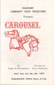
Programme - Programme 'Carousel' by Eaglehawk Commuity Youth Productions
"Carousel' is a musical in two acts, music by Richard Rodgers and book and lyrics by Oscar Hammerstein II Music Programme for "Carousel" - a musical in 2 acts, opening May 2nd-5th, 1979 - A5 booklet with 16 pages - booklet consisting of lists of individuals participating and organizing the concert, advertisements, acknowledgments, synopsis of story, musical numbers and scenes.programme, concert -
 Bendigo Historical Society Inc.
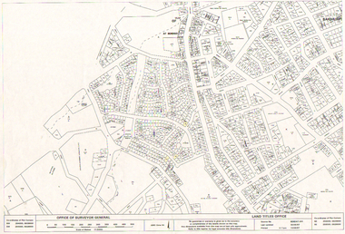
Map - LONG GULLY HISTORY GROUP COLLECTION: LONG GULLY AREA
Copy of a map showing streets and allotments in the Long Gully area, last updated 30/05/97, printed 19/06/97. Made by the Land Titles Office. Some street names, reserves and allotment numbers are printed on the map.bendigo, history, long gully history group, the long gully history group - long gully area, land titles office, office of surveyor general, city of bendigo, shire of marong, state electricity commission -
 Bendigo Historical Society Inc.
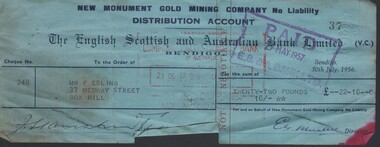
Document - MCCOLL, RANKIN AND STANISTREET COLLECTION: NEW MONUMENT GMC - CHEQUES (USED), 30 July 1956
Document. Cheques (blue) dated 30 July 1956. Cheque numbers - 248 - 287 -309 - 323 -330 - 345 - 347 - 386. New Monument GMC N/L Distribution Account. The English Scottish & Australian Bank Limited.McColl, Rankin & Stanistreetorganization, business, new monument gmc n/l, mccoll, rankin & stanistreet, new monument gmc, the english scottish & australian bank limited, gold mining, cheques -
 Wangaratta RSL Sub Branch
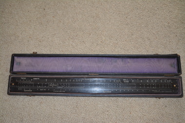
Instrument - Pilot Balloon Slide Rule
The Mark II Pilot Balloon Slide Rule was made of wood laminated with heavy white plastic with a length of 24.5-in. and width of 2.5 inches. Mark II rules were manufactured in Australia by W & G (Melbourne). The W & G rule differs only slightly from the English A. G. Thornton LTD rule. The W & G rule uses serif fonts and has some fiducial marks that the English rule lacks. Exact dates of production are not known but the MK II is known to have started production by 1927. The printed scales are engraved in the plastic faces. The slide rule has 4 captive cursors (glass windows and brass guides) that ride in slots on the top and bottom edges. Each can be moved independently of one another. The cursors are missing from this item. Brass knobs at both ends of the slide facilitate its movement. The case is fabric covered wood with felt lining. No known history for this item as located in a property after purchase. The Pilot Balloon slide rule is used to convert the observed azimuth and elevation readings into wind velocity and direction records. The use of slide rules was abandoned with the wide spread adoption of computers and programs to do the calculations, as well as the decline in the use of optical pilot balloon theodolites.Made in Australia by White & Gillespie (Melb) Pty Ltd. Established in 1910, the firm was involved mainly in printing plate manufacture, but during the Second World War it manufactured a variety of navigational aids and range finding devices for the military. About 250,000 instruments were made during that period. After the war the company produced, among other items, drawing instruments and slide rules. The case is fabric covered wood with felt fabric lining containing a long black laminate ruler with numerous white markings and numbers. Top of the ruler is in three sections with the centre section movable by small gold metal knobs at either end. This slide rule contains a engraved notation on the rear face "IMPORTANT. NORMALLY NUMBER OF GRATICULE SCALE DIVISIONS PER RADIAN (K) X LENGTH OF TAIL IN FEET (I) = 12X 105. IN OTHER CASES MULTIPLY GRATICULE READINGS BY 1.2/KI BEFORE CALCULATION ON RULE" Top of Slide Rule - RAAF Ident No G268/480 Serial WG/22pilot balloon slide rule, raaf -
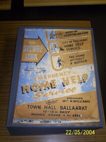 Ballarat Tramway Museum
Ephemera - Tramcar Internal Roof Ad, City of Ballaarat, "Ballarat Home Help Service", 1969
Medium weight cardboard sheet with printed sheet, pasted to one side, advertising City of Ballaarat home help service - blue brown and black printing. Has telephone numbers B5245 and 2255. Used as an internal roof advertisement in trams.Some pencil marksballarat, community services, city of ballaarat -
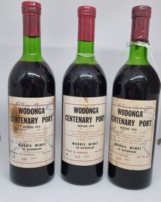 Wodonga & District Historical Society Inc
Memorabilia - Bottles - Wodonga Centenary Port, Morris Wines of Rutherglen, 1976
This bottling of Wodonga Centenary Port was provided by Morris Wines of Rutherglen to celebrate the Centenary of local government in Wodonga. Wodonga Shire was created in 1876 when the colonial government agreed to ratepayers' petitions to have their northern area severed from the Yackandandah Shire and form a new municipality. In 1976 celebrations were held to mark this milestone. These bottles were donated to the Wodonga & District Historical by Jenny Brown nee Terrill daughter of former Wodonga Shire President, Councillor J. A. Terrill. These bottles of the Wodonga Centenary Port were signed by all of the councillors serving in 1976.This artefact represents the celebrations for the centenary of local government in Wodonga.3 bottles of port produced by Morris Wines of Rutherglen. This bottling celebrated the centenary of local government in Wodonga. The label is on beige paper with a maroon outline and black text. These bottle have been autographed and bear the numbers 238. 248 and 343.On Label: "WODONGA / CENTENARY PORT/BOTTLED 1976/ THIS 1975 PORT WAS SPECIALLY/ SELECTED & BOTTLED TO CELEBRATE / ONE HUNDRED YEARS OF LOCAL GOVERNMENT IN WODONGA/ 10th MARCH 1876 - 1976/ MORRIS WINES / OF RUTHERGLEN/ PRODUCT OF AUSTRALIA NET 738 ml/ NO 343 E2314wodonga shire council, wodonga local government, wodonga local government centenary -
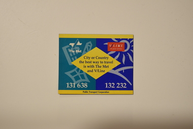 Melbourne Tram Museum
Decorative object - PTC & V/Line Magnet, Public Transport Corporation (PTC), c.1990s
Used for decorative purposes on magnetic surfaces, such as on a fridge door, while also an advertisement for the Public Transport Corporation and V/Line.A marketing material associated with a now-superceded transit agency (since the 1990s). The V/Line logo shown was distinct in the 1990s, which has since changed as well.Rectangular sheet magnet with the logos of the PTC and V/Line on the top. In the centre reads, "City or Country/the best way to travel/is with The Met/and V/Line." At the bottom phone numbers for both groups are advertised, above the text "Public Transport Corporation."public transport, public transport corporation, ptc, v-line -
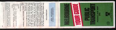 Melbourne Tram Museum
Map, Ministry of Transport, Melbourne Public Transport Map - No. 11, 1980
Map No. 11 dated on rear as 1980 - Includes description of tram and bus routes, private bus routes. Has contact details for bookings and lost property etc and how to use the map. Yields information about Melbourne public transport services in 1980Fold out map (27 sections 9 across x 3 deep), "Public Transport Map", coloured of Melbourne's Tram and Bus routes, route numbers, rail lines, detailed for the central part of Melbourne and the outer Metropolitan services.tramways, melbourne, tram services, bus services, railways, maps -
 Melbourne Tram Museum
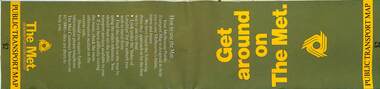
Map, The Met, Public Transport Map - Get around on The Met, c1987
Undated map - c1987 - Neighbourhood and travelcard tickets, has a photo of the front of B2 2004, includes a map of the travelcard neighbourhoods, commuter passes and The Met contact details.Yields information about Melbourne public transport services in c1987Fold out map (36 sections 9 across x 4 deep), "Public Transport Map", coloured of Melbourne's Tram and Bus routes, route numbers, rail lines, detailed for the central part of Melbourne and the outer Metropolitan services.tramways, melbourne, tram services, bus services, railways, maps, travelcard, neighbourhood tickets -
 Melbourne Tram Museum
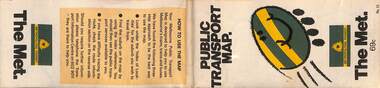
Map, The Met, "Public Transport Map - No. 13", 1984
Map No. 13 undated with the buzzing bee symbol on the front and throughout at the time of the introduction of the neighbourhoods. Includes description of tram and bus routes, private bus routes. Has contact details for bookings and lost property etc and how to use the map. Gives extensive details of the neighbourhood tickets and their used. C1984.Yields information about Melbourne public transport services in 1984.Fold out map (36 sections 9 across x 4 deep), "Public Transport Map", coloured of Melbourne's Tram and Bus routes, route numbers, rail lines, detailed for the central part of Melbourne and the outer Metropolitan services.tramways, melbourne, tram services, bus services, maps -
 Melbourne Tram Museum
Map, Public Transport Corporation (PTC), "Public Transport Map of Melbourne", 5/1995
Map Includes description of tram and bus routes, private bus routes, and rail lines. Has contact details for bookings and lost property etc and how to use the map. Gives details of the ticketing system, along with photographs of the various modes. Dated May 1995 with a stylised image of some of Melbourne's landmarks on the cover. Published by the Public Transport Corporation.Yields information about Melbourne public transport services in 1995.Fold out map (36 sections 9 across x 4 deep), "Public Transport Map", coloured of Melbourne's Tram and Bus routes, route numbers, rail lines, detailed for the central part of Melbourne and the outer Metropolitan services.tramways, melbourne, tram services, bus services, maps, railways -
 Bendigo Historical Society Inc.
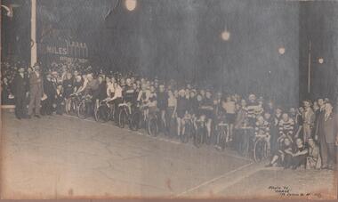
Photograph - GROUP PHOTO OF CYCLISTS/SUPPORTERS, early 1920's ?
Sepia photo: large group of cyclists, with supporters and crowd behind. On LH side of photo: sign with 'miles', numbers 1 - 5, and 'Rowlands' written on bottom of board. In bottom RH side 'Photo by 'Darge' 175 Collins Street, Melbourne.'Darge' 175 Collins St., Melbourne.sport, cycling -
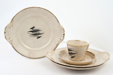 Uniting Church Archives - Synod of Victoria
Plate, cup and saucer
Tag on cup: "Cup & saucer from Sydney Rd Methodist church used by the Ladies' Guild from ? until 1936 - 38 when each member paid 2/6 - 5/- for a set and the money went to buying a new set. This belonged to Mrs David Phillips".Four cream china serving plates, one cup and saucer with black transfer print and gold edging. Serving plates registration numbers CH011.3; CH011.4; CH011.5 & CH011.6. Cup registration number CH011.1. Saucer registration number CH011.2. Brunswick Wesleyan church. brunsick wesleyan church, wesleyan methodist -
 Melbourne Tram Museum
Document, Ministry of Transport, Melbourne Public Transport Map - No. 12, 1982
Map No. 12 - Includes description of tram and bus routes, private bus routes. On the front cover is composite image of Melbourne public transport vehicles. Has contact details for bookings and lost property etc and how to use the map. Priced at 40c, issue No. 12 of c1982. Has details of the then new Travelcard ticket system. Yields information about Melbourne public transport services in 1982.Fold out map (36 sections 9 across x 4 deep), "Public Transport Map", coloured of Melbourne's Tram and Bus routes, route numbers, rail lines, detailed for the central part of Melbourne and the outer Metropolitan services.tramways, melbourne, tram services, bus services, railways, travelcard -
Bendigo Historical Society Inc.
Document - RESIDENCE AREAS REGISTER: DOCUMENTS FROM VOLUME 19, 1920-1940
Documents: Collection of drawings, sketches of land allocations (with names) and plans that relate to Residence Areas Register Volume 19.Match page numbers 0f Volume 19 - 11006.1 (Box 56) Covers 1920s to 1930s. Sorted by page number.land sales, residence areas, plans, sandhurst, bendigo -
 Melbourne Tram Museum
Map, Ministry of Transport, Melbourne Public Transport Map - No. 9, 1979
Map No. 9 - Includes description of tram and bus routes, private bus routes. Has contact details for bookings and lost property etc and how to use the map. Yields information about Melbourne public transport services in 1979Fold out map (27 sections 9 across x 3 deep), "Public Transport Map", coloured of Melbourne's Tram and Bus routes, route numbers, rail lines, detailed for the central part of Melbourne and the outer Metropolitan services.tramways, melbourne, tram services, bus services, railways, travelcard, maps -
 Flagstaff Hill Maritime Museum and Village
Document - Navigation Chart, Admiralty Office, Lady Bay and Warrnambool Harbour, 1893
This navigation cart of Lady Bay and Warrnambool Harbour was originally surveyed in 1870 but this version includes the update for magnetic variation in 1893. Since the printing of the chart several annotations have been added. These include an additional stamp dated 15-8-1910, a handwritten comment across the top of the page dated August 1910, and another handwritten comment regarding the ‘Proposed Extension of Dock’ dated 19-2-1925, plus connected drawings, notes and figures. The 1925 proposal on this chart may have been a reaction to the Royal Commission of 1923, when the damaged stonework on the seaward side of the Warrnambool Breakwater, caused by the action of the sea, was the subject of enquiry. A conference between the Public Works, Water Commission and the Harbour Trust concluded that it would less costly to make repairs to prevent further damage rather than replaced the damage portion of the wall. A contract was raised in late 1924 to deposit rubble on the damaged side of the breakwater to minimise the Southern Ocean’s destructive action and work had started by August 1925. The Breakwater construction had begun in 1874 and was completed in 1890. The Victorian Government had commissioned Sir John Coode, a British harbour engineer, to present a plan to complete the Warrnambool Breakwater but his original plan was too expensive. He prepared a revised plan for a shorter structure. The construction proved to be too short to protect adequately from the weather and didn't allow enough depth for larger vessels to come into port. The decreasing trade was further affected by siltation in the bay due to the breakwater, and the completion of the railway line. The situation of the harbour became a real problem by 1910 and required continuous dredging. In 1914 the Breakwater was extended but proved to be a failure because the work began to subside and by 1920 about two thirds of the harbour was silted up. Alterations made in the 1920's increased the silting problem and by the 1940's the harbour was no longer used. More alterations were made in the 1950's and 1960's. This chart is significant for its strong connection to the maritime history of Warrnambool Harbour and Lady Bay and the Warrnambool Breakwater. The Warrnambool Breakwater is registered as a place of significance on the Victorian Heritage Database (VHR H2024). The Warrnambool Breakwater is one of the most important late 19th century maritime engineering projects in Victoria and significant in the development of Victorian coastal shipping. It is also significant for its connection with British harbour engineer, Sir John Coode. The chart is a historical record of structures existing in 1893; the Warrnambool Jetties, Warrnambool Breakwater in Lady Bay, the leading lights (lighthouses), streets, roads, bridges and many buildings. It also shows the lay of the land and seabed. Navigation Chart: Lady Bay and Warrnambool Harbour, Australia - South Coast - Victoria. Surveyed by Nav. Lieut. H.J. Stanley, R.N., 1870. Updated for Magnetic Variation, 1893. The rectangular chart is printed on heavy cream paper. Stamps are shaped rectangular, oval and round. Around the Breakwater and Jetty area are handwritten notes, dotted and joined lines, numbers and signatures, and shading of red and green. The chart shows the surrounds of Warrnambool Harbour, Lady Bay, the Breakwater and Jetty, roads, bridges and the streets in Warrnambool. It has sounding details, and angles of line from the leading lights.Stamp, rectangular, including "AUG 1910" Stamp, double oval " - - - -CHART" Stamp, hand drawn, red circle, with "B" inside Hand written note "22-8-1910 - - - - - of surveying C. Ca - - - request of 15-8-10 [initials] " Notes and lines in red pen, including a grid of sounding numbers: "1300" "1050" "1200" "Possible Extension of Dock" "19-2-25" "Dock Dredged to 20 Ft" Notes and lines in blue pen "Extension of Dock to accommodate vessels drawing 20 Feet" and "Light not visible south of this line" Red dots (4) with yellow highlight at both leading lights, breakwater and jettyflagstaff hill, warrnambool, flagstaff hill maritime museum & village, maritime museum, maritime village, shipwreck coast, map, chart, navigation chart, plan, lady bay, warrnambool harbour, port of warrnambool, breakwater, jetty, pier, dock extension, proposed extension, vhr h2024, 1870, 1893, 1910, 1925, warrnambool town late 1800s, warrnambool streets late 1800s royal commission, 1923, public works, water commission, harbour trust, victorian harbours, sir jon coode -
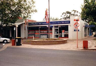 Hume City Civic Collection
Photograph, Prior to 1995
This corner was occupied in the past by Lloyds Chemist shop which was a weatherboard structure. The photograph was taken prior to 1995 when 8 digit telephone numbers were introduced throughout the Metropolitan area.A coloured photograph of the streetscape of the SW corner of Evans and Brook Street. The main shop is occupied by L. J Whorlow, Real Estate Agents. A white car is parked on the LHS of the photograph and a garbage bin is placed next to a concrete bollard by the kerb and on the brick paved footpath.real estate agents, shopping centres, whorlow, l. j., lloyd, l. m., first national real estate, evans street, brook street, george evans collection -
Lakes Entrance Regional Historical Society (operating as Lakes Entrance History Centre & Museum)
Photograph, Lakes Post Newspaper, 1/11/1999 12:00:00 AM
Also two other colour photographs taken at the Reconciliation Ceremony at Lake Tyers numbers 04129.1 and 04129.2 size 10 x 15 cm. Fifteen recorded sites of aboriginal massacarsColour photograph of Reconciliation Ceremony at Lake Tyers Victoriaaboriginals -
Lakes Entrance Regional Historical Society (operating as Lakes Entrance History Centre & Museum)
Photograph, V Bennett, 1980 c
Five other colour photographs showing works in progress levelling crest of Myer Street numbers 04298.1, .2, .3, .4 .5, .6 size 10 x 15 cmColour photograph showing front end loader and tip truck removing crest of Myer Street prior to relevelling and sealing Lakes Entrance Victoriacelebrations, parks -
Moorabbin Air Museum
Machine - Armstrong Siddeley Cheetah 300Hp Air Cooled 7 Cylinder Radial
Historical Details: . Description: The Armstrong Siddeley Cheetah was designed in Britain and originally known as the Lynx. It was built in large numbers and powered both the Avro Anson and Airspeed Oxford.. Level of Importance: State -
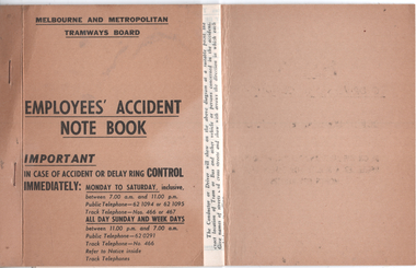 Melbourne Tram Museum
Administrative record, Melbourne & Metropolitan Tramways Board (MMTB), "Employees's Accident Note Book", 1960's
Used by crews to report accidents to the MMTB Claims section using a standard form process. Crews were trained how to use these as part of the initial training. Based on the phone numbers 1960s.Demonstrates the forms used to report accidents.Admin record or note book - card covers, with five tear off or perforated forms stapled to the inside.tramways, mmtb, accidents, reports, crews -
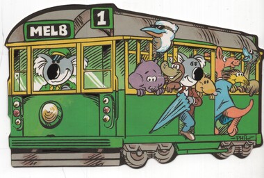 Melbourne Tram Museum
Postcard - Cartoon postcard image W class tram, Nucolorvue Publishing, 1970s?
Postcard - cartoon image of a Melbourne W class tram with Australian animals on the tram, driven by a koala. Card by Nue-color-vue, card numbers 11 ML 318, NCV 6064. Demonstrates a cartoon image combining iconic image of Melbourne trams and Australian animals.Postcard colour - Cartoon image W class tram - Nu-color-vuetrams, tramways, cartoons, w class tram -
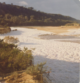 Lakes Entrance Regional Historical Society (operating as Lakes Entrance History Centre & Museum)
Photograph, Marie Fish, 1987c
Also three other colour phoptographs of foam at entrance and on lake after severe storm in June July 1978 numbers 03847.1, 03847.2, 03847.3 size 9 x 8.5 cmColour photograph showing foam across the open entrance after a severe storm, timbered hill in distance, Lake Bunga Victoriatopography, waterways -
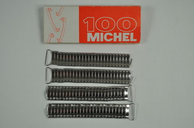 Kiewa Valley Historical Society
Michel Clips
This medical / hospital equipment was used in the Tawonga District General Hospital which was built in the 1950s specifically for the increase in population due to the Kiewa Hydro Scheme.Historical: Shows the development of scientific hospital equipment. Provenance: Used in the Tawonga District General Hospital which was remote and therefore required good equipment. Good condition and good interpretation capacity.Inside white and orange cardboard packet. Metal ends like wire attached to metal sections adjacent to each other. Used instead of stitches. Requires applicator and remover.'100 Michel' (in white writing on orange background) and other side - '18/8' circled (white numbers in orange circle). 'Mt Beauty' handwrittenmedical equipment. hospital equipment. tawonga. mt beauty. medical. hospital. nurse. doctor. medical aid. health. stitches. -
Kiewa Valley Historical Society
IV Bottle with Airway
This medical / hospital equipment was used in the Tawonga District General Hospital which was built in the 1950s specifically for the increase in population due to the Kiewa Hydro Scheme.Historical: Shows the development of scientific hospital equipment. Provenance: Used in the Tawonga District General Hospital which was remote and therefore required good equipment.Used in the delivery of intravenous fluids Clear glass bottle with plastic black lid sealed and with 2 holes through it. A short hard plastic straw for air is in one hole and in the other a long hard plastic straw going down to the bottom. The jar is embossed with measurements up to 1000ml. There is a torn label on the bottle. Near the bottom is a white plastic handle which may be able to be attached to something.Embossed measurements with numbers and lines. Also 1000 ml. The label has the title, in blue, Dextrose 10% w/v. On the bottom 8146 is embossed.medical equipment. hospital equipment. tawonga. mt beauty. intravenous fluids -
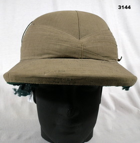 Bendigo Military Museum
Uniform - HELMET, PITH
This hat was sent home to Laanecoorie, from Malaya, in 1941 by Driver Cyril John Johnson VX36298, 1 Coy A.A.S.C whilst a POW. Cyril enlisted in the 2nd AIF on 17.6.1940 age 22 years 2 months. Posted to 8th Div Petrol Coy Seymour 25.7.1940, hospital 12.8.1940 with Mumps, rejoin unit 31.8.1940, embark for overseas 2.2.1941, disembark Singapore 19.2.1941. He is listed as missing on 16.2.1942 and later listed as POW in a Thai Camp no date. (He was on the Burma Railway) Last entry on his records states Presumed to be dead 12.9.1944 SWPA. (South West Pacific Area) He with hundreds of others were on the Japanese prison ship Rakuyo Maru to Japan when it was sunk by an American submarine. The hand written signatures on the hat include high ranking AIF Officers, major local Officials and dozens of 8th Division AIF soldiers. British pattern Pith Helmet, khaki coloured cotton cloth with brown leather strap over the top. Large quantity of hand written names on top. Inside rim has green felt lining. Dome section is plaited red silk with manufacturer's label at crest. Hat band is brown leather.On top written in pen & ink: Many army numbers & names of soldiers and some dignitaries.. On top written in ink: To Dad etc from Cyril.military equipment - army, costume - male headwear -
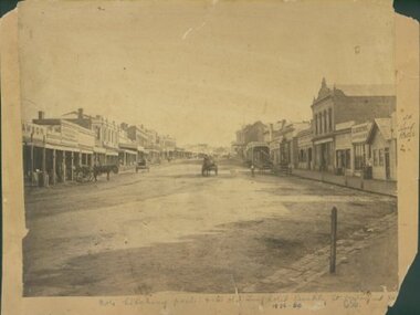 Ararat & District Historical Society (operating the Langi Morgala Museum)
Barkly Street, Ararat, perhaps 1870s
This is one of a dozen or so pictures of very early Ararat held by Langi Morgala Museum, and can be compared to a succession of later photographs to illustrate the growth of the town of Ararat. The date suggested by the inscription on the front is probably a reference to some other occurrence, since the street seems far to built-up for 1856-1860. The date is more likely the 1870s, or even the 1880sThis photograph, though not in good condition, is one of the few in the possession of Langi Morgala Museum that shows very early Ararat. It is of regional significance, which would be enhanced if a firmer date could be established. This cardboard-mounted large photograph is not in very good condition, but some parts of the image are still clear. There are permanent inscriptions on both front and back, not done in sympathy with the age and importance of the item.On front: "Note hitching posts and the old Turf Hotel, Barkly Street cont[illegible] / 1856-60". On back: museum stamp and photo numbers.barkly-street, ararat, horse, horse-driven, early-ararat, business, commercial