Showing 1813 items
matching shown
-
 Ballarat Tramway Museum
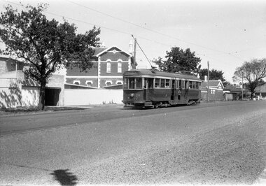
Negative - Tram 38 Mercer Street, Laurie Gallop, early 1956
Photo shows Tram 38 Mercer Street, near The Esplanade with the destination of Belmont. One of a set of photos was taken between 15/2/1956 and 3/3/1956 when services operated only between Belmont and North before the final closure of the Belmont route on 25/31956 and that bogie tram 31 is not shown on the board, having gone to Ballarat on 15/2/1956 - see item 5554. See item 8213 for an article on the Geelong system by Keith Kings. Yields information about the Geelong operations toward the closure of the tram system.Black and white Negative - 120 sizetramways, geelong, tram 38, mercer st -
 Ballarat Tramway Museum
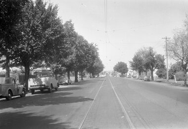
Negative - Moorabool St, looking south at the Kardinia Park loop, Laurie Gallop, early 1956
Photo shows Moorabool St, looking south at the Kardinia Park loop. One of a set of photos was taken between 15/2/1956 and 3/3/1956 when services operated only between Belmont and North before the final closure of the Belmont route on 25/31956 and that bogie tram 31 is not shown on the board, having gone to Ballarat on 15/2/1956 - see item 5554. See item 8213 for an article on the Geelong system by Keith Kings. Yields information about the Geelong tram system.Black and white Negative - 120 sizetramways, geelong, moorabool st, kardinia park loop -
 Merri-bek City Council
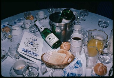
C-type print, Rennie Ellis, Grand Final breakfast 1982, 1982
Rennie Ellis was an Australian documentary photographer and a key figure in Australian visual culture. Grand Final breakfast 1982 depicts a cluttered table during a football Grand Final day breakfast. The messily covered tablecloth, as well as the appearance of alcohol at a morning event, displays the signature larrikin attitude and passion with which football events are undertaken in Australia. This work was shown in the 2017 Counihan Gallery exhibition Leather Poisoning, along with many other works by Ellis, capturing the nation’s love of the game. Donated by the Rennie Ellis Photographic Archive -
 Ringwood and District Historical Society
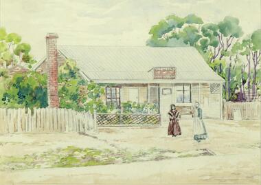
Painting, Winifred Miles, "First Post Office 1883" (Ringwood) - Water colour on paper by Winifred Miles (1884-1944), Undated, later than 1910
"Alexander Colquhoun [Herald art critic 1914-1922 and feature writer for the Age 1926-1941] ... took private students in the first decade of the century, and one of these was Winifred Miles, who after her marriage in 1910 lived the remainder of her life in Ringwood. ... (She) began by doing charcoal studies of animals when she was in Balranald, but in later years moved to oils and then watercolours, travelling around Ringwood to find places to paint by means of a pony-driven governess-cart. She won prizes for paintings in the Royal Melbourne Shows." - Hugh Anderson - Ringwood, Place of Many Eagles [p.217].Painting with cardboard border in glass-fronted frame. Painted from an original black & white photograph, Catalogue Reg No. 1347 recorded as "Ringwood's first Post Office showing first Postmistress, Miss M. Thompson and her mother. 1890". (South side of Main Street (Maroondah Highway), approximately 300 meters west of Ringwood Railway Station). Writing on back of original photograph reads, "Grandma and Auntie Martha Thomson 1890". (Difference in painting date and photograph date indicates years as shown are approximate only). Sticker on back of frame - "Ringwood Framing Gallery, 233 Whitehorse Road Ringwood, Phone 8704930" -
 Bendigo Historical Society Inc.
Map - FORTUNA HUSTLER'S MINE - PLAN OF FORTUNA HUSTLER'S MINE
Map and plan of the Fortuna Hustler's Mine on the Hustler's Line of Reefs. Bulletin No 33, Plate No 1. Plan gives depth of the different levels. Bendigo Railway Station is on the map and also a number of the streets. Carpenter Street is called Cemetery Road. Also on the Hustler's Line of Reef is the Summer Hill Shaft. Shown is the Hustler's Royal Reserve No 2 Lease. Map has the Geological Survey of Victoria crest. It is signed by H Whit ?an Underground Survey Office Bendigo, September 1913. This item has not been scanned or photographed.map, fortuna hustler's mine, plan of fortuna hustler's mine, hustler's royal reserve no 2 lease, summer hill shaft, hustler's line of reef -
 Bendigo Historical Society Inc.
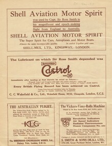
Document - BASIL WATSON COLLECTION: 'THE ROSS SMITH FLIGHT FROM ENGLAND TO AUSTRALIA' - TRAVELOGUE PROMOTION, c. 1920
Booklet: 'The Ross Smith Flight from England to Australia' - 4 page Travelogue booklet promotion for the Lowell Thomas Travelogues series, Re flight from England to Australia. On cover ' Under the patronage of HRH The Prince of Wales, The Ross Smith Flight from England to Australia' Includes short story of the flight by Capt. Sir Ross Smith, KB, MC, DFC, AFC. , map of flight and photos of Ross and Keith Smith. List of pictures shown in the travelogue. Original signatures of Ross and Keith Smith on the front cover.person, individual, ross smith -
 Whitehorse Historical Society Inc.
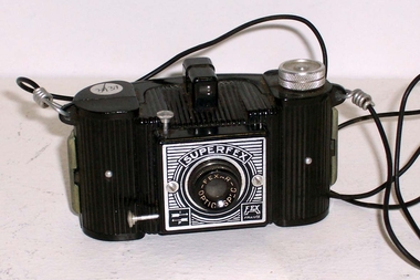
Functional object - Camera, c1940
Superfex Camera - made of plastic with a Fexar Spec Optic made by Fritz Kaftanski. Originally made in Prague in Czechosovakia from 1938 - 1942. This camera was made in Lyon, France in 1942 after Company moved from Prague. This is shown on the lower right front of the camera. The back is removable using the two clips on each side. Provisions made for two spools - one blank, the other for the 127 film role. Shutter button on top front of camera. M & B lever for exposure settings is on the side. A carrying cord is fitted.Superfex - Fexar spec Optic - Francephotography, cameras -
 Whitehorse Historical Society Inc.
Photograph, Mitcham R.S.L. Memorial Hall, 13/06/1986 12:00:00 AM
2 Coloured photos of Mitcham R.S.L. Memorial Hall, north eastern corner Whitehorse Road and McDowall Street. The Hall is comprehensively documented in the society's archives. See also NP1068. War Memorial in foreground Buildings shown to left of hall occupy a vacant block that reached almost to Mitcham Road. Barrie Gracie's Milk Bar and Mr. Holly's shoe repairs filled the remaining space. The large vacant space was used for impromptu cricket and football games and was akso the location for the circuses the regularly visited Mitcham.mitcham memorial hall, war memorials, soldiers memorial, mitcham -
 Southern Sherbrooke Historical Society Inc.
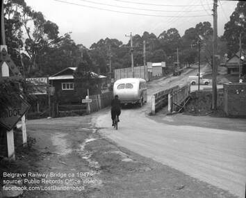
Photograph, Belgrave Railway Bridge, 1947
Belgrave railway bridge looking towards Bayview Road from Terrys Ave, 1947. It shows a bus crossing the bridge onto (now) Belgrave-Gembrook Road, followed by a male cyclist wearing a dark overcoat and bowler hat. A man wearing a homburg hat is crossing the footbridge beside the main bridge towards the main street. There is a pale van parked (or driving past) a dairy on the corner of Bayview Rd and Belgrave-Gembrook Road. A brick toilet block is shown with a sign saying 'MEN' on a nearby lamp post. -
Ballarat Tramway Museum
Document - Exercise Book, Artrite, "Staff Available book", 9/10/2017 12:00:00 AM
Cream covered exercise book, 96 pages, ruled, used from January 1998 to March 2103 as a BTM tramcar crew availability book. Ruled with red biro into 2 months per page. Gives details of the traffic staff availability to Roster Clerk prior to preparing roster. When roster drawn off, month shown as closed. Gives names of various people who worked on the trams over the period the book was in use. See Reg Item 725 for the period August 1981 to December 1997.trams, tramways, btm, rosters, personnel -
 Ballarat Tramway Museum
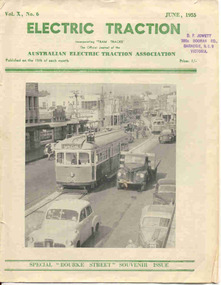
Magazine, Australian Electric Traction Association (AETA), "Electric Traction", Jun. 1955
Yields information about the construction method of High St Northcote Melbourne, Bourke St and the construction of the new trams at the time for Melbourne.June 1955 issue of Electric Traction, Vol X No. 6 - featuring Melbourne No.996 in High St Northcote, during the construction of the tramway with two trams being ferried to the new Preston depot. See detail caption. Only one line shown, the second is under construction in the rear. Features articles on the construction of the Bourke St routes, construction of new W7 (known then as SW6c), tramcars, possible new routes in Melbourne, news from Pittsburgh, Victorian Railways, Bourke St. roll, AETA notes.Stamp of "D.F. Jowett etc" in top left hand corner.trams, tramways, melbourne, bourke st, tramcar construction -
 Ballarat Tramway Museum
Slide - 35mm slide/s, Ben Parle, 8/04/1958 12:00:00 AM
Kodachrome Transparency - 35mm slide - cardboard mount, with one side with red border and words "Kodachrome Transparency / Processed by Kodak" top and bottom. Photo taken by Ben Parle 8/4/1958. Has slide No. "12" stamped in black in top corner. Photo of Ballarat No. 11, Wendouree Parade, St Aidans Drive. Tram has the destination of Mt Pleasant. Note the cannon in the background, to the left of the tram. Both stone gate pillars shown. For high resolution scan see btm2871.tif"Lake Wendouree & Gardens / Ballarat" / "8-4-58"tramways, trams, wendouree parade, st aidans drive, tram 11 -
 Ballarat Tramway Museum
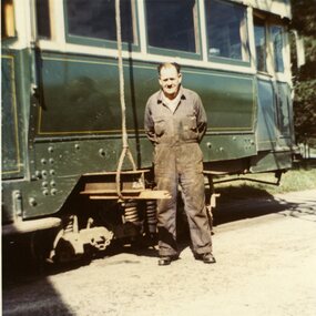
Photograph - Colour Print, Lilian Butler, Sep. 1971
Possibly has a strong association with Mr. E. Davis, a SEC Ballarat depot worker.Colour print of a group of Mr. E. Davis standing along side a bogie car being readied for a lift to be loaded in Wendouree Parade. Possibly tram 37 as has doors - conversion similar to 38. See Reg Item 1861 for staff photo - not shown in photo. Item was placed in an envelope marked "Mr. Davis" - retained with photograph in storage folder. Photo printed on Kodak Paper. Photograph by Lilian Butler? See Reg Item 6533i7 for a colour slide. Negative of this image (35mm) filed with print.in ink on rear "With my compliments Lilian Butler"trams, tramways, sec, depot, personnel, closure, tram disposal, tram 37 -
 Bendigo Historical Society Inc.
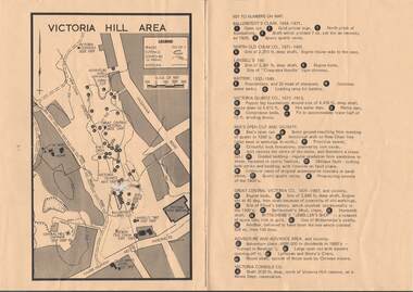
Map - VICTORIA HILL AREA
Map of Victoria Hill Area printed on yellow paper. Details of tracks, cuttings, contours (in Metres) and Anticline. Location of mines, open cuts and buildings are shown. Numbers on map are: Ballerstedt's Claim 1 - 5; North Old Chum Co. 6; Lansell's 180, 7,8,11; Battery 9.10.12; Victoria Quartz Co. 13 - 17; Rae's Open Cut and Vicinity 18 - 28, Great Central Victoria Co 29 - 36, Adventure and Advance Area and vicinity 37 - 40 and Victoria Consols Co 41.map, bendigo, victoria hill, victoria hill area, victoria consols, new chum anticline, great central victoria, rae's open cut, w rae's home, victoria quartz, ballerstedt's open cut, lansell's 180, north old chum, central nell gwynne, john brown factory, gold mines hotel, cleopatra needle type chimney, floyd's battery, ballerstedt's 24yd claim, humboldt shaft, wittscheibe's jeweller's shop, luffsman and sterry's claim, victoria hill reserve, mines dept reervation -
 Bayside Gallery - Bayside City Council Art & Heritage Collection
Photograph, Department of Crown Lands and Survey, Victoria, Melbourne Project: Brighton, Hampton, Sandringham, 1976
The Department of Crown Lands and Survey (1857-1983) was responsible for the administration of survey and mapping and the sale, occupation and management of crown land throughout its existence. This aerial photograph shows parts of Brighton, Hampton and Sandringham and was taken on 1 December 1976brighton, department of crown lands and survey, aerial photograph, bayside, port phillip bay, map, cartographic material, hampton, sandringham, green point, sandringham yacht club, south road, beach road, hampton street, melbourne project 1976 -
 Bayside Gallery - Bayside City Council Art & Heritage Collection
Photograph, Department of Crown Lands and Survey, Victoria, Melbourne Project: Brighton and Hampton, 1976
The Department of Crown Lands and Survey (1857-1983) was responsible for the administration of survey and mapping and the sale, occupation and management of crown land throughout its existence. This aerial photograph shows parts of Brighton and Hampton and was taken on 1 December 1976. brighton, department of crown lands and survey, aerial photograph, bayside, port phillip bay, map, cartographic material, melbourne project 1976, brighton yacht club, middle brighton baths, hampton, green point, brighton beach, south road, the esplanade, hampton street -
 Ballarat Tramway Museum
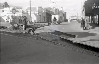
Negative, Wal Jack, early 1950's
Yields information about the reconstruction of the curve on the Mt Pleasant line at Stones Corner.Negative and Digital images of the Wal Jack Ballarat Negative file of the relay of the outer rail at Stones Corner on the Mt Pleasant line. Shows removed rails and methodology of the work. Photo taken at 1220 as shown on the clock - all workers at lunch. In the view are the Listers COR service station, the Inspector chatting with a person, the Ballarat East Post Office and the Stones retail store. The first welding truck (cloth covered roof) with a wandering lead device. See Reg Item 7740 for a photo of similar work at Main and Barkly St.trams, tramways, stones corner, trackwork, track repairs, main road, victoria st, mt pleasant, inspectors, welding -
Ballarat Tramway Museum
Functional object - Destination Roll, NSW Department of Road Transport and tramways, "Newcastle"
Destination roll use din a Newcastle tram - on linen, black background with various colours and white letters. Each destination 10" high. 6 joins in roll, each approx. 800 to 900 long section. Letters in caps. Destinations shown are: West Wal'send Wallsend and Platsburg New Lambton Lambton Broadmeadow Adamstown Waratah Merewether B'H (Beach) Newcastle Tighe's Hill Mayfield Glebe Boreas Road Special Depot Sport Grd Show Grd Racecourse Speedway Telford St Hamilton Depottram, trams, newcastle, destination roll -
 Kew Historical Society Inc
Plan - Subdivision Plan, St Helliers Estate, Kew, circa 1910, c.1910
Pru Sanderson, in her groundbreaking ‘City of Kew Urban Conservation Study : Volume 2 - Development History’ (1988), summarised the periods of urban development and subdivisions of land in Kew. The periods that she identified included 1845-1880, 1880-1893, 1893-1921, 1921-1933, 1933-1943, and Post-War Development. These periods were selected as they represented periods of rapid growth or decline in urban development. An obvious starting point for Sanderson’s groupings involved population growth and the associated economic cycles. These cycles also highlighted urban expansion onto land that was predominantly rural, although in other cases it represented the decline and breakup of large estates. A number of the plans in the Kew Historical Society’s collection can also be found in other collections, such as those of the State Library of Victoria and the Boroondara Library Service. A number are however unique to the collection.Subdivision plans are historically important documents used as evidence of the growth of suburbs in Australia. They frequently provide information about when the land was sold on which a built structure was subsequently constructed as well as evidence relating to surveyors and real estate and financial agents. The numerous subdivision plans in the Kew Historical Society's collection represent working documents, ranging from the initial sketches made in planning a subdivision to printed plans on which auctioneers or agents listed the prices for which individual lots were sold. In a number of cases, the reverse of a subdivision plan in the collection includes a photograph of a house that was also for sale by the agent. These photographs provide significant heritage information relating house design and decoration, fencing and household gardens.In the subdivision of part of Crown Portion 82, bordered by John and Sackville Streets and Cotham and Burke Roads, over 100 lots were offered for sale. In addition to the designated lots, a number of key locations are also identified. These include the Genazzano Convent to the north of Cotham Road, the Reservoir, St Hilary’s and the land holding of Colonel Parnell on the corner of John Street and Cotham Road. On the Plan, No. 5064, is the handwritten name ‘St. Hellier’s Estate’. St. Helliers, the home of the Dumaresq family is shown beside St. Hilary’s.subdivision plans - kew, st helliers estate -
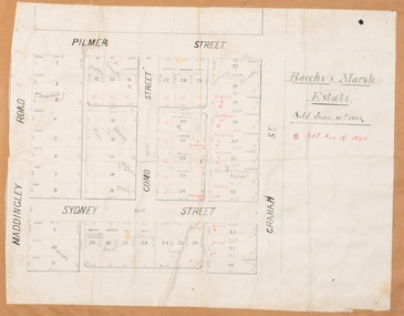 Bacchus Marsh & District Historical Society
Map, Bacchus Marsh Estate sold 30th June 1888 and sold 28 December 1895
Blocks of land in this area of Bacchus Marsh were sold in lots between 1888 and the late 1890s. This map shows sales made in 1888 and 1895.Single page map showing allotments of land bounded by Pilmer Street, Graham Street, Sydney Street and Maddingley Road (Grant Street) in Bacchus Marsh.The area is dissected by Como Street down the central area. 43 blocks of land are shown with the names of buyers or sellers in 1888 written in black in. Buyers or sellers for December 1895 are written in red ink. Part of a set of maps which are pasted into a bound volume containing 76 maps or plans in total. High resolution digital image stored on BMDHS computer network. bacchus marsh victoria maps, land sales bacchus marsh, pilmer street bacchus marsh, graham street bacchus marsh, sydney street bacchus marsh, como street bacchus marsh, maddingley road bacchus marsh, grant street bacchus marsh -
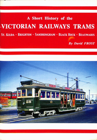 Ballarat Tramway Museum
Book, David Frost, "A short history of the Victorian Railways Trams - St Kilda - Brighton - Sandringham - Black Rock - Beaumaris", May. 2006
Book - 20 pages + card covers, centre stapled titled "A short history of the Victorian Railways Trams - St Kilda - Brighton - Sandringham - Black Rock - Beaumaris". Covers have colour photographs on the outside. Page 11 has a map of the two tramways with the tram lines and features shown in red. Written by David Frost, published May 2006 by Tramway Publications. Edited by Dean Filgate. Provides details of the background of the tramways, Elwood depot fire, Sandringham depot, closure and an Epilogue Has details of the Author.trams, tramways, vr trams, elwood, st kilda brighton, sandringham, beaumaris -
Bendigo Historical Society Inc.
Document - MARKS COLLECTION: PARISH PLAN OF WHITE HILLS
Sepia coloured map showing allotments in Parish of Sandhurst (White Hills) Written on LH side of map town and Suburban Lots White Hills Parish of Sandhurst. Scale is shown in chains. Surveyed by Horage Walker. Photo lithographed at the Department of Lands & Survey, Melbourne by J.Noone, Price 1/-. 6th. January 1865. Map shows Race Course Reserve at top of sheet, Municipal boundary is marked on LH side. Comments re vegetation throughout map. For example, poor soil timbered with Box scrub.bendigo, planning, white hills parish map -
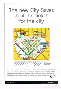 Melbourne Tram Museum
Poster, Metlink, "City Saver Metcards", Jan. 2004
Poster - A3 - full colour printed on gloss white paper, advertising the City Saver Metcards and the availability within the city area shown by a map with the various routes and station stations. Also shows places of interest. Gives details as to the ticket system and the costs. Published by Metlink, has Metlink logos. Weblink - to a website published by Rob O'Regan - http://www.robx1.net/ accessed 3/1/2015 - gives the date of introduction as 1/1/2004 - see http://www.robx1.net/victkt/metcard/html/citysav.htmtrams, tramways, posters, metlink, tickets, metcard -
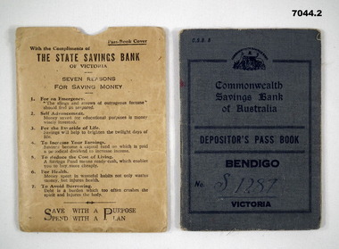 Bendigo Military Museum
Financial record - PASS BOOK, Commonwealth Bank & State Savings Bank, 1943
Refers to a collection of Bendigo Voluntary Aid Detachment. See Cat No 7028 for all the collection.1. This is a pocket sized bank book. Printing on front is in a dark blue ink. The cover is blue buckram. inside are bank, branch details and hours, plus a line by line bank financial record of deposits and withdrawals. The first record is a deposit of 35 pounds in April 1943. The last balance is shown as 3 ponds 5 shillings and 10 pence. 1 June 1955 Interest. 2. This is a stout khaki bank book holder. Printed articles on it are: - "State Savings Bank Victoria" plus seven reasons for saving money.1. Inside the book is No. “S1287” written in ink. The depositors title written in ink is :- Bendigo Voluntary Aid Detachment No. 352 stamped inside back cover is number “C968324” 2. Nil.ww2, bank book, vad -
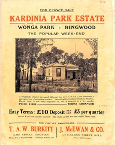 Ringwood and District Historical Society
Flyer, Land Sale Brochure, Kardinia Park Estate, North Ringwood, Vic. - circa 1948
Folded buff-coloured land sale advertisement for Kardinia Park Estate in Warranwood area of North Ringwood, including terms of sale, area map, layout plan of the estate, and summary of local facilities and services. Front page features photograph of a man and dog in front of a house captioned as Lot 1 on four acres shown on the estate layout as cnr of Brysons Road and Range View Parade (later Omeo Parade). Second page includes bushland swimming pool photograph and promotional information for prospective buyers.Subdivision includes Kardinia Crescent, Wonga Road, Brysons Road, Range View Parade (later Omeo Parade), Motor Coach Road (later Wonga Park Road, then Warranwood Road). (Agent/s) T.A.W. Burkitt, Main Street, Ringwood, Phone (9 to 6) Ringwood 242, Evenings, Ringwood 157, and J. McEwan & Co, 317 Collins Street, Melbourne, Phone 6750 Central. -
 Melbourne Tram Museum
Uniform - Badge/s, The Met, late 1890's
Badges - The Met - personnel employee numbers - Three parts - holder made from gold coloured plastic with a metal Met (the flying one) logo fixed above the holder and fitted with a pin. A engraved plastic, gold front, black rear number was then inserted and glued into the holder as shown by badge number 1041 where the number is loose. Two items - numbers 017 in original plastic packet and 1041. See Reg Item 3777.3 for another example. Additional badges - Nos 863, 591 and 5432.trams, tramways, badges, the met, mta, personnel, employees -
 Melbourne Tram Museum
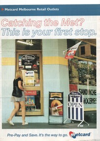
Pamphlet, VicTrip, "Catching the Met? - This is your first stop.", Apr. 1999
Pamphlet - four fold - special size - full colour titled "Catching the Met? - This is your first stop." giving the list of Metcard shops in central and suburban Melbourne, along with maps of the tram and train systems. The maps show both Yarra and Swanston trams with route numbers along with Bayside and Hillside trains and the various ticket zones at the time. The number of car parking spots at each station also shown. On the rear is general information about Metcard with ticket machines, and validators. List dated effective from April 1999.trams, tramways, maps, metcard, yarra trams, swanston trams, hillside trains, bayside trains, tickets -
 Melbourne Tram Museum
Uniform - Badge, 1900's
Cap Badge for the Melbourne and Tramway Omnibus Co staff. Has abbreviation of "MTOCo". Made from a cast brass item, nickel plated, part of their uniform. Cast in the form of the handwritten or script word/s and underlined. On the rear, silver soldered on are two brass loops at either of the badge to enable badge to be sewn or fitted with clips onto the cap. No manufacturer's name on the rear of the badge. Two copies held, one fitted with a clip - as shown in photograph. See Reg Item 1923 for a photo showing how it was used for a Conductor's cap.trams, tramways, cap badge, hat badge, uniforms, mto co -
 Melbourne Tram Museum
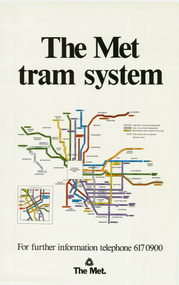
Poster, The Met, "The Met Tram System", mid 1990's
Poster - full colour on semi gloss paper titled "The Met Tram System" showing in a diagrammatic form the Melbourne tram routes, major street names, route numbers, principal suburbs, terminal names, central area (pre Docklands, post light rail to St Kilda and Port Melbourne) and ticket zones. Has The Met logo and the Public Transport Corporation names on the bottom. Mid 1990's, Batman Ave still shown. 2nd copy added 2-2-2019 and scanned, replaced image file.trams, tramways, melbourne, tramways, tram routes, map, posters -
 Ballarat Tramway Museum
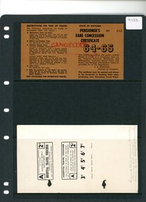
Ephemera - Ticket, Electric Supply Co of Vic. (ESCo), Pensioners Fare Concession Ticket and Hospital Travel Voucher
Gives an understanding of the variety of special purpose tickets issued by the Electric Supply Company for use on the Provincial Tramways of Victoria.The Pensioner's Fare Concession Certificate is for the year 64-65. Printed on tan colored card, with black print. It notes Restrictions on the time of travel. The reverse gives additional information about the ticket, including the expiry date. There is a space for the ticket-holder's signature. The Hospital travel voucher is printed on white card with black ink. It is issued by the Electricity supply Department for use on Provincial Trams. The ticket is not transferable. This appears to be a sample and shows that the 2d ticket as shown can be altered in value to 3d,4d,5d,6d or 7d. The Pensioner's Fare Concession Certificate has the word "Cancelled" stamped in red ink across both face and back. The Hospital Travel Voucher has "Issued to Base hospitals Ben & Bal who issue to pensioners. Collected by SEC. Charged to Health Dept". This wording is written in pencil on the front of the ticket example.electric supply company, tickets, provincial tramways