Showing 174944 items matching "beach-street"
-
 Eltham District Historical Society Inc
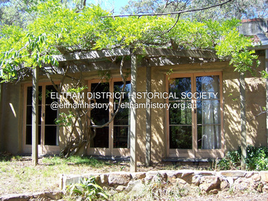
Photograph - Digital Photograph, Marguerite Marshall, Former home of Professor William MacMahon Ball, York Street, Eltham, 24 May 2007
Situated at the eastern end of York Street, Eltham, 'Shinrone', the former home of Professor William (Mac) MacMahon Ball was one of the first in the Shire of Eltham to incorporate mud-brick. Professor MacMahon Ball, a political scientist, writer, broadcaster and diplomat and family moved to York Street, Eltham in 1945 into a timber cottage built around the 1890s and in poor repair. Mac asked Alistair Knox to renovate the home and he expanded the living area and added verandahs. In 1948 Montsalvat artist and sculptor Sonia Skipper supervised the building of most of the mud-brick studio. Neighbour Gordon Ford made the mud-bricks. Mac also asked John Harcourt, who had worked with him as a journalist in shortwave broadcasting, to build a pise (rammed earth) and stone addition to the largely timber house. Harcourt built two bedrooms - including an attic bedroom - a balcony with a shower and toilet, and a fireplace and chimney of local stone. Published: Nillumbik Now and Then / Marguerite Marshall 2008; photographs Alan King with Marguerite Marshall.; p141This collection of almost 130 photos about places and people within the Shire of Nillumbik, an urban and rural municipality in Melbourne's north, contributes to an understanding of the history of the Shire. Published in 2008 immediately prior to the Black Saturday bushfires of February 7, 2009, it documents sites that were impacted, and in some cases destroyed by the fires. It includes photographs taken especially for the publication, creating a unique time capsule representing the Shire in the early 21st century. It remains the most recent comprehenesive publication devoted to the Shire's history connecting local residents to the past. nillumbik now and then (marshall-king) collection, eltham, alistair knox, gordon ford, john harcourt, mudbrick construction, pise construction, professor macmahon ball, shinrone, sonia skipper, york street -
 Eltham District Historical Society Inc
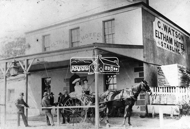
Photograph, Watson's Eltham Hotel, Maria Street, Eltham, c.1900
Christoher Watson's Eltham Hotel, cnr Maria Street (Main Road) and Pitt Street, Eltham. Christopher Watson in centre (bareheaded). Reproduced on p60 of 'Pioneers & Painters' The hotel was constructed in the 1850s immediately following the discovery of gold in Victoria. The original founder, a Mr Warren. engaged a builder named Wallace, to erect the hotel, and being unable to finance it, the story goes, handed it over to Mr Wallace, who finished the job, and received the first licence. The building was constructed of hard basaltic blue stone, quarried in the Eltham district, and partly of bricks made at Eltham. At that time the town owned not only an hotel, but a flour mill, a brewery, a brickworks, and other important industries. The hotel was carried on for the benefit of the first owners for over 30 years and was then purchased by Mr Chris Watson. The hotel was in the early days a well-known resting place for the gold diggers during the gold rush at Woods' Point. A new hotel was erected on the same site by Mr H. Watson in 1925.This photo forms part of a collection of photographs gathered by the Shire of Eltham for their centenary project book,"Pioneers and Painters: 100 years of the Shire of Eltham" by Alan Marshall (1971). The collection of over 500 images is held in partnership between Eltham District Historical Society and Yarra Plenty Regional Library (Eltham Library) and is now formally known as the 'The Shire of Eltham Pioneers Photograph Collection.' It is significant in being the first community sourced collection representing the places and people of the Shire's first one hundred years.Digital imagechristopher watson, eltham, hotel, main road, maria street, pioneers and painters, pitt street, shire of eltham pioneers photograph collection, watson's hotel -
 Eltham District Historical Society Inc
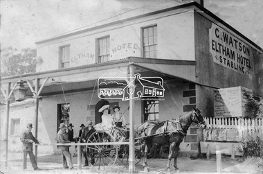
Photograph, Watson's Eltham Hotel, Maria Street, Eltham, c.1900
Christoher Watson's Eltham Hotel, cnr Maria Street (Main Road) and Pitt Street, Eltham. Christopher Watson in centre (bareheaded). Reproduced on p60 of 'Pioneers & Painters' The hotel was constructed in the 1850s immediately following the discovery of gold in Victoria. The original founder, a Mr Warren. engaged a builder named Wallace, to erect the hotel, and being unable to finance it, the story goes, handed it over to Mr Wallace, who finished the job, and received the first licence. The building was constructed of hard basaltic blue stone, quarried in the Eltham district, and partly of bricks made at Eltham. At that time the town owned not only an hotel, but a flour mill, a brewery, a brickworks, and other important industries. The hotel was carried on for the benefit of the first owners for over 30 years and was then purchased by Mr Chris Watson. The hotel was in the early days a well-known resting place for the gold diggers during the gold rush at Woods' Point. A new hotel was erected on the same site by Mr H. Watson in 1925.Early photo of Eltham Hotel which has been on site in various forms since mid 1800sSepia photograph mounted on cardInscribed on back: "Property of Mr Albert Watson, 53 Yarra St, Heidelberg. Christopher Watson (bare headed) Given to Marion Huggett December 1977 c.1900 son of Watson Snr behind cart"christopher watson, eltham, eltham hotel, main road, maria street, pioneers and painters, pitt street, shire of eltham pioneers photograph collection, watson's hotel -
 Port Fairy Historical Society Museum and Archives
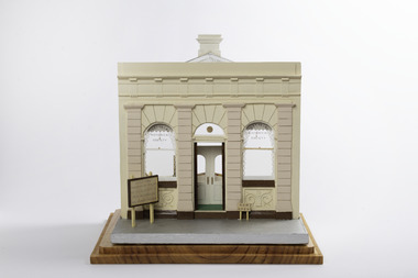
Mixed media - Model, Port Fairy Historical Society, Early 1970's
This model was part of a panorama of 11 pieces designed from an almanac in the 1892 Port Fairy Gazette. The Panorama was used in a Historical Display in the historical society rooms in Bank Street but displays the more modern use when the building became the property of the Port Fairy Historical SocietyThis Panorama was part of an eleven piece Panorama of the Streetscape of Port Fairy in 1982. Made by a local resident.Small handmade model of a shop front from the 1892 almanac.In glass display box. Filled with furniture and display cases as it was in the early 1970`sBuilt 1889 Purchased Port Fairy Historical Society as their headquarters Members Welcome Now open Windows "Port Fairy Historical Society" This is model of 24 Bank Street First Museum 1977-1992panorama, model, almanac, historical society, bank street, mewkill -
 Rutherglen Historical Society
Image, Herald & Weekly Times, 1954
On left of photo is the Rutherglen Hotel. On the right, in the foreground, is the Star Hotel, with the Rutherglen Sun newspaper office next to it.Black and white photograph of Main Street, Rutherglen, looking west from the High Street intersection. Written on back of photo: "In W.T. Mar 10. 1954. page 54. The Main Street Rutherglen 3/6" Rubber stamp on back of photo with copyright information.main street rutherglen, rutherglen hotel, star hotel, rutherglen sun, hotels -
 Warrnambool and District Historical Society Inc.
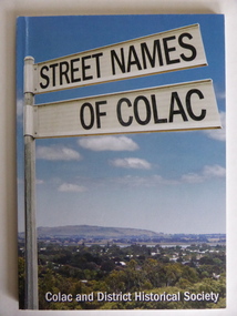
Book, Streets of Colac, 2008
This is a book giving information on the streets of Colac and the origins of the names. Colac is a city 150 kilometres south west of Melbourne and is a commercial centre for a major agricultural area. It is situated near the 3rd largest volcanic plain in the world and European settlement began in 1837. The book was commenced by Ian McIntosh in the 1970s and in 2005 the Colac and District Historical Society took on the project again with the major editors being Ida and Andrew McIntosh. This book is of interest, particularly those in the Western District of Victoria, as it contains information on Colac streets, many of which were named after pioneers of the district. The book will be useful for research. This is a soft cover book of 60 pages. The cover has a blue background and features a colour photograph (mainly in green, blue and white tonings) of a panorama of the Colac district. The photograph extends over the front and back covers. The book contains the names and name origins of Colac streets in alphabetical order and many black and white photographs. The pages have a glued binding. Front Cover: ‘Street Names of Colac’ ‘Colac and District Historical Society’ history of colac, colac and district historical society, street names of colac, ian mcintosh -
 Lakes Entrance Historical Society
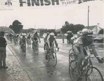
Photograph - Cycling race Lakes Entrance, Lakes Post Newspaper, 7/10/1991 12:00:00 AM
final stage of Patties Lakes Cycling Tour organised by Frank Daly, shows cyclists on Roadnight Street , Stock Street on the right hand side . Other photos 04027.1 riders in Roadknight Street Lakes Entrance approaching and crossing the finish line with Mourilyan Street on the left. Photo 04027.2 cyclists crossing the finish line on Roadnight Street , Stock Street on the right hand side Black and white photograph taken at the final stage of Patties Lakes Cycling Tour organised by Frank Daly, shows cyclists on Roadnight Street , Stock Street on the right hand side . Other photos 04027.1 riders in Roadknight Street Lakes Entrance approaching and crossing the finish line with Mourilyan Street on the left. Photo 04027.2 cyclists crossing the finish line on Roadnight Street , Stock Street on the right hand side sports, cycling, recreation -
 Eltham District Historical Society Inc
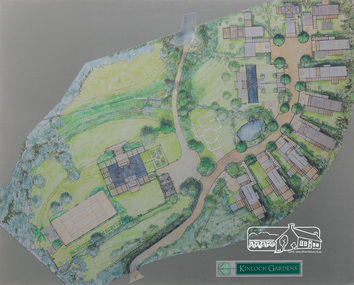
Drawing, Architectural Concept Plan: Kinloch Gardens proposed development, 93 Arthur Street, Eltham, 1997, 1997
Proposed design for Kinloch Gardens project with 12 sites illustrated plus Kinloch Main House. Ian Jelbart owned the entire Woodridge Estate but retained the top of the hill in Arthur Street until this development in 1997-1998, which he developed in conjunction with Graeme Gunn. Ian Jelbart inherited the land from his father who had purchased it cheap during the Great Depression. Kinloch is a castle in Scotland. Ink, wash and pencil on paper adhered to 13mm thick polyurethane boardKinloch Gardensarthur street, eltham, graeme gunn, ian jelbart, jelbart property, kinloch gardens -
 Eltham District Historical Society Inc
Photograph, View in Eltham looking south along Main road from Bridge Street, 1902
Looking south along Main Road from the south side of the intersection of Bridge Street with Main Road. Post Office (Anne Hunniford Postmistress) on left then the Commercial Bank of Australasia building. The house on the right, 'Derril,' was purchased by Walter Gahan in 1924 and was demolished in 1968 when Main Road was widened. In the distance on the left is Watson's Hotel and on the right (opposite side of the main road, Morris's Hotel Cross Ref: 0624This photo forms part of a collection of photographs gathered by the Shire of Eltham for their centenary project book,"Pioneers and Painters: 100 years of the Shire of Eltham" by Alan Marshall (1971). The collection of over 500 images is held in partnership between Eltham District Historical Society and Yarra Plenty Regional Library (Eltham Library) and is now formally known as the 'The Shire of Eltham Pioneers Photograph Collection.' It is significant in being the first community sourced collection representing the places and people of the Shire's first one hundred years.Digital image Print 14 x 24 cm 35 mm B&W negativeanne jane hunniford (1855-1928), bridge street, commercial bank of australia, derril, eltham, gahan house, main road, morris's hotel, post office, shire of eltham pioneers photograph collection, watsons hotel -
 Whitehorse Historical Society Inc.
Photograph, Street naming
The dignitaries in front are (from left), Hon Bruce Scott Minister for Veteran Affairs, Raleigh Armstrong, Hon Phillip Barelli MHR Deakin, Pia Armstrong and other RSL members. The young Mitcham men who did not return from WW2 were Alwyn Till, Owen Loftus, Ross Fenton, Ronald Peake,and Brian Cox. The streets bear their christian names and are directly behind the Rangeview Shopping CentreColoured photo copy of nine people at the laying of a wreath near a plaque in the footpath near the Rangeview shopsstreet names, till alwyn, loftus owen, fenton ross, peake ronald, cox brian, scott bruce hon., barelli phillip hon., armstrong raleigh, armstrong pat., world war 1039-1945, plaques -
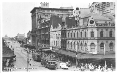 Melbourne Tram Museum
Postcard, Valentine's, "Swanston Street Melbourne", late 1930s
Valentine's postcard titled "Swanston Street Melbourne", Number V8, looking south along Swanston St from the Town Hall portico. Two W2 class trams 441 (City route 64) and possibly 492 (City Route 4) are northbound. Signs for Royal Mail Hotel, C Danman & Co, R C N Searby Health Centre, Fayrefield Hats, and Calder Jewellery store are in the view.Yields information about Swanston Street, during the late 1930s.Postcard - printed, unused, Valentine Seriestrams, tramways, swanston st, tram 441, w2 class -
 Eltham District Historical Society Inc
Negative - Photograph, Main Road, Eltham, looking south from Bridge Street, 1906-1907
Looking south along Main Road from the south side of the intersection of Bridge Street with Main Road. Anne Hunniford's Post Office and Burgoyne's store on left. Miss Harriet (Minnie) Williams's Cash Drapery Mart (est. 1902 and enlarged in 1906), also known as Eltham House on the right. Harriet (Minnie) Williams was born London, 1857, the daughter of George John Williams (1812-1895) and Jane Mansfield (1812-1895). In September 1885 she was operating Williams’s Drapery Establishment in premises on Main Road owned by R. Wallis who advertised them to let in September 1885. In 1902 she opened Williams’s Cash Drapery Mart at the southwest corner of Bridge Street and Main Road (opposite the Post Office), owned by W.J. Taylor. In 1906 she bought the premises and one quarter acre of land and expanded the business with a re-opening in April 1906. Harriet was also well-known and esteemed as an active worker in Methodist circles and also Superintendent of the Sunday School. Harriet fell ill in August 1907 and died 15 August. She is buried in Eltham Cemetery with her good friend Ada Ford. Note also the gas street lamp on right. Watson's Hotel on corner of Pitt Street visible in distance. The CBA bank building is hidden behind trees, the chimney and part roof visible. The photo was possibly taken by John Henry Clark of Clark Bros Photographers who operated from 25 Thompson Street, Windsor near Prahan 1894-1914. Evelyn Observer and Bourke East Record (Vic. : 1902 - 1917), Friday 30 March 1906, page 5 ________________________________________ ELTHAM. (FROM OUR OWN CORRESPONDENT.) For over three years Miss Williams has carried on a drapery business in very small and inconvenient premises opposite the Eltham post-office. Recently she bought the building and a quarter-acre of land from Mr. W. J. Taylor. Thus having a free hand, she at once matured plans to enlarge and improve the premises to make them suitable for her growing business. The result being that she consulted Mr Roach, contractor, of Heidelberg, put the matter in his hands, and now he has completed in a very satisfactory manner and up-to-date style extensive improvements. A large addition, of very neat and attractive design, with three large windows, has been built right along the front of the old building, and the counters and inside fittings are very neat and convenient, harmonizing well with the attractive outside appearance. Miss Williams has now got in a large now stock of goods, and is making extensive arrangements for a “reopening week," commencing 2nd April, during which time she will make 10 per cent reduction on all cash purchases in the form of gifts of that value. Miss Williams has gone to considerable expense and liability both, in the enlargement and improvement of the premises and in purchasing additional stock. We therefore trust that the public will stand by her by heartily and en masse patronizing her re-opening effort to show their appreciation of pluck in this advance movement. Google Street View Feb 2017: https://www.google.com.au/maps/@-37.7191341,145.1462046,3a,50.5y,191.91h,88.27t/data=!3m6!1e1!3m4!1sARwwqEQfMSfH9oTWWapPgQ!2e0!7i13312!8i6656 This photo forms part of a collection of photographs gathered by the Shire of Eltham for their centenary project book,"Pioneers and Painters: 100 years of the Shire of Eltham" by Alan Marshall (1971). The collection of over 500 images is held in partnership between Eltham District Historical Society and Yarra Plenty Regional Library (Eltham Library) and is now formally known as the 'The Shire of Eltham Pioneers Photograph Collection.' It is significant in being the first community sourced collection representing the places and people of the Shire's first one hundred years.Digital image (x2) 4 x 5 inch B&W Neg B&W Print 16 x 25 cmsepp, shire of eltham pioneers photograph collection, eltham, main road, anne jane hunniford, burgoyne store, christopher watson, commercial bank of australia, drapery store, eltham house, gas lamp, harriet (minnie) williams, post office, street lamp, watson's hotel, williams's cash drapery mart, clark bros. photo -
 Kew Historical Society Inc
Archive (Sub-series) - Subject File, Congregational Church (Walpole Street, Kew), 1958
Various partiesReference, Research, InformationSecondary Values (KHS Imposed Order)Subject file containing information about the Congregational Church in Walpole Street, Kew (demolished 1979). The file contains numerous original and copied primary sources as well as short histories and correspondence between the Kew Historical Society and the Historic Buildings Preservation Council when it was proposed to demolish the church. Following the demolition of the Church, an aged care facility - Bodalla - was erected (since demolished). The file contains some information on Bodalla and a foundation stone relating to the former Church which was placed on the site. In the file, there is a photocopy of a brass plaque from 1860 that refers to the architect being George Wharton and the builders Messrs. Leach & Bicknell. congregational church -- kew (vic), churches -- kew (vic), walpole street -- kew (vic.)congregational church -- kew (vic), churches -- kew (vic), walpole street -- kew (vic.) -
University of Melbourne, Burnley Campus Archives
Plan, Swan Street Entrance. Also see B15.0352, 1988-1998
(1) 1 coloured and 2 copies, hand drawn , and 4 tracing paper sketches. Concept and Drawing by Steve Mullany, Lecturer V.C.A.H. Burnley, 09.12.1988. (2) 2 copies on tracing paper, original on paper with some additional notation and 3 copies of Landscape Plan by Steve Mullany 3 Feb 1989. (3) Photocopy of Project Eden, Swan Street, Richmond - Landscape Plan LA2 Project No 682 by Mark Mc Wha Pty. Ltd. Nov 1997. Includes Irrigation and Plant Schedule. (4) Coloured, Swan St Frontage Planting Scheme by P. Tulk for AMRAD 19.2.1998. -
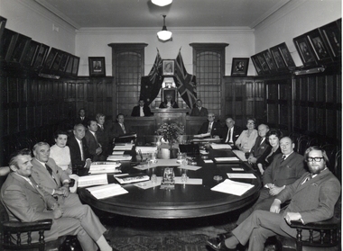 Ballarat Heritage Services
Photograph - Photograph - Black and White, City of Kew Councillors at the last Meeting in the Kew Town Hall, Walpole Street, c1972
The former Kew Town Hall was used for an Op Shop for a number of years before it was demolished for a supermarket.City of Kew Councillors at the last Meeting in the Kew Town Hall, Walpole Street. Left to right going around the table: Cr Dick Cremin, Cr Ivan Wade, Cr Dorothy Buchanan, Cr Jack Ryan, Cr George McKenzie , Cr Gerard Petrie, Cr Jack Gervasoni, behind these councillors sits Brian Robinson, Laurie Johnson (Town Clerk), Cr Leo Hawkins (Mayor), George Russell (City Engineer) , ?, ?, Cr Gladys "Bon" Fink, [possible Cr Percival "Percy" Watts?]' Cr Phyllis Hore, [Possibly Cr Frank O'Brien?], Cr Alan Hutchisoncity of kew, councillors, kew town hall, dick cremin, ivan wade, jack ryan, gerrie petrie, jack gervasoni, john hogan gervasoni, alan hutchinson, gerard petrie, jack ryan, george mckenzie, brian robinson, laurie johnson, leo hawkins, george russell, gladys "bon" fink, bon fink, percival watts, phyllis hore, frank o'brien -
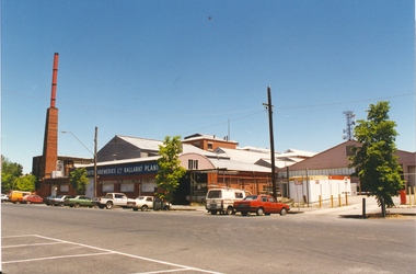 Federation University Historical Collection
Photograph, Former Ballarat Brewing Company Pre-demolition
Ballarat Brewing Company in from Lydiard Street South.ballarat brewing company, chimney, brew tower, lydiard street south -
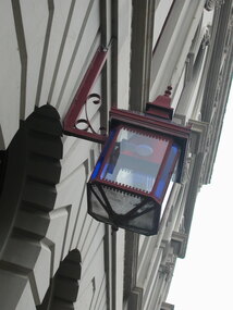 Ballarat Heritage Services
Photograph - Colour, Lamp outside Craig's Royal Hotel, Ballarat
Colour photograph of Craig's Royal Hotel, with street lamp. street lamp, hotel lamp, craig's royal hotel, lighting, hotel lamp -
 Ballarat Heritage Services
Photograph - Photograph - Colour, Castlemaine Bluestone Gutter, 2004, 28/06/2004
Colour photograph of a bluestone gutter in Urquhart Street, Castlemaine.castlemaine, gutter, bluestone, infrasctructure -
 Ballarat Heritage Services
Photograph - Photograph - Colour, 33 Wills St, Kew, c1973, c1973
In the 1980s and 1990s this property was owned by Pedro and Isobel Jiminez.A brick building in Wills Street, Studley Park, Kew.33 wills st, kew, pedro jiminez, isobel jiminez -
 Ballarat Heritage Services
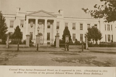
Photograph - Black and White, Ballarat Hospital, 1935, 1935
Black and white image of the Ballarat Hospital in Drummond Street.ballarat hospital, drummond st -
 Ballarat Heritage Services
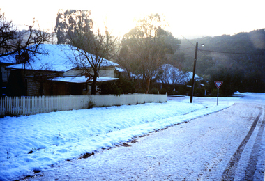
Photograph - Colour, Snow at Hepburn Springs, c2002
Colour photographs snow at Seventh Street Hepburn Springs.hepburn springs, snow, actea, wanda inn -
 Kew Historical Society Inc
Photograph, Robert Baker, Kew Junction Streetscape, 2017, 01/09/2017
Photograph of the junction of Cotham Road and High Street, Kew. the block - cotham road - kew (vic), cotham road - kew (vic) -
 Ballarat Heritage Services
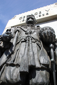
Photograph - Digital photographs, L.J. Gervasoni, King George V Ballarat, c2014
Bronze sculpture of George V in Sturt Street Ballarat.ballarat, heritage, statue, king george v, sturt street, sturt street gardens -
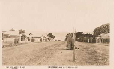 Phillip Island and District Historical Society Inc.
Photograph - Post Card, Early 1900's
One of 5 postcards donated by G. Haywood.Sepia postcard of the Main Street in Cowes. Houses on the left and Cowes Motor Garage on right. Sea in the background."The Rose Series P. 3413" "Main Street, Cowes, Phillip Is., Vic."main street cowes, phillip island, cowes phillip island, phillip island, g. haywood -
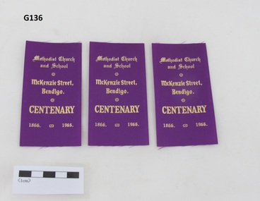 Uniting Church Archives - Synod of Victoria
Memorabilia
G136.1, G136.2 and G136.3 purple synthetic ribbon with gold text celebrating McKenzie Street Bendigo's Centenary."Methodist Church and School McKenzie Street, Bendigo" "CENTENARY" "1866" "1966"methodist church mckenzie street bendigo -
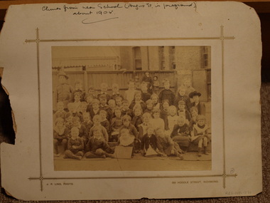 Clunes Museum
Photograph, J.P. LIND, CIRCA 1905
PHOTOGRAPH OF SCHOOL CHILDREN - CIRCA 1905, J P LIND PHOTO 183 HODDLE STREET RICHMONDCLUNES FROM NEAR SCHOOL (ANGUS STREET IN FOREGROUND), ABOUT 1905 local history, photography, photographs, schools, 1552 -
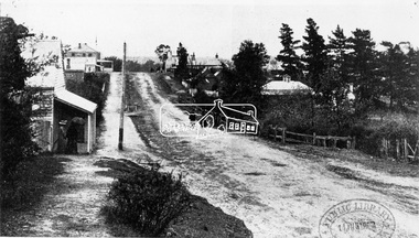
 Eltham District Historical Society Inc
Photograph, J.H. Clark, Eltham, Main Road from Arthur Street towards station
View of Main Road, Eltham from Arthur Street towards the railway station which can be seen on the left. Cross Ref: 609 (opposite direction) Photographer: J.H. Clark John Henry Clark was the youngest of three boys born to William Henry Clark (1823-1877) and Maria White (1843-1914). He and his brothers, William Charles Clark (1872-1945), Clement Kent Clark (1874-1912) operated a photography business (Clark Bros.) from 25 Thomas Street, Windsor near Prahran during the period c.1894 to 1914. Following death of Clement in September 1912 and their mother in 1914, the Clark Bros business appears to have dissolved, the premises demolished, and a new house was under construction in 1915. John set up business independently in 1914 operating out of 29 Moor Street, Fitzroy where he is registered in the 1914 and 1915 Electoral Rolls. By 1916 John had relocated to Eltham where he continued his practice as a photographer and took many of the early images around the district of Little Eltham. Around 1930 John changed professions and opened a small cobbler's shop in 1931 near the pond opposite Dalton Street adjacent to the Jarrold family cottage. He never married and continued his profession as a bootmaker from this little shop, maintaining a close relationship with Mrs Jarrold for the rest of their lives. His bootmaker shop remains today beside the Whitecloud cottage and is one of only three remaining shops in the area from the early 20th century. There are a couple of images of Eltham taken by Clark Bros. in the Eltham District Historical Society collection, one such example being Hunniford’s Post Office with Miss Anne Hunniford out front (EDHS_00140 - marked on the back of the print, Clark Bros., 25 Thomas St. Windsor), which would date this image between c.1894 and 1914. Other early images of Eltham taken by John Henry Clark are marked on the face “J. H. Clark Photo” and it is assumed these are dated between 1914 and 1930. It is noted that the Grant of Probate for John H Clark of Eltham South dated 5 April !957 (513/387) records his occupation as "X Photographer".\This photo forms part of a collection of photographs gathered by the Shire of Eltham for their centenary project book,"Pioneers and Painters: 100 years of the Shire of Eltham" by Alan Marshall (1971). The collection of over 500 images is held in partnership between Eltham District Historical Society and Yarra Plenty Regional Library (Eltham Library) and is now formally known as 'The Shire of Eltham Pioneers Photograph Collection.' It is significant in being the first community sourced collection representing the places and people of the Shire's first one hundred years.Digital imagesepp, shire of eltham pioneers photograph collection, eltham, main road, railway station, eltham railway station, j.h. clark photo -
 Eltham District Historical Society Inc
Photograph, Eltham War Memorial 1914-1918. Cnr. Main Road and Bridge Street, 3 August 1919
Dated 1919, the Eltham Obelisk is decorated with wreaths, most likely for what was originally known as Armistice Day though now known as Remembrance Day, 11 November. The location of the Obelisk at the corner of Bridge Street and Main Road became known as Obelisk Corner and the Bridge Street bridge was also referred to as Obelisk Bridge. The Eltham Obelisk was originally located at the corner of Bridge and Main Roads in 1919. In 1943 (WW2) the local community commenced plans to establish the Eltham War Memorial, a living memorial to benefit the children as opposed to a one in stone as per the obelisk. The Eltham War Memorial Trust was established in 1945. In 1947 the Trust intended for the Obelisk to be relocated from Bridge Street and Main Road to the Garden of Remembrance which was planned as part of the Baby Health Centre which was to be the first of three buildings of the Eltham War Memorial to be built in 1951. In 1951 the Eltham RSL was invited to be represented on the Eltham War Memorial Trust. Around this time, with pending roadworks, the obelisk was relocated to the front garden of the Eltham RSL sub branch on Main Road for safe keeping. In 2007, a suggestion was proposed by Harry Gilham (President, EDHS) to John Cohen (ERSL) to claim a special site along with the historic Shillinglaw trees on the now vacant former Eltham Shire Office site adjacent to the Eltham War Memorial precinct for relocation of the obelisk. In 2010 following the financial collapse and sale of the Eltham RSL Sub-Branch property and amalgamation with the Montmorency Eltham RSL sub-branch, the location of the obelisk was again in immediate jepoardy and in conjunction with Nillumbik Shire Council, the obelisk was relocated in front of the Eltham War Memorial buildings in preparation for the Dawn Service on Anzac Day 2012.This photo forms part of a collection of photographs gathered by the Shire of Eltham for their centenary project book,"Pioneers and Painters: 100 years of the Shire of Eltham" by Alan Marshall (1971). The collection of over 500 images is held in partnership between Eltham District Historical Society and Yarra Plenty Regional Library (Eltham Library) and is now formally known as 'The Shire of Eltham Pioneers Photograph Collection.' It is significant in being the first community sourced collection representing the places and people of the Shire's first one hundred years.Digital image 4 x 5 inch B&W Negsepp, shire of eltham pioneers photograph collection, eltham, main road, bridge street, eltham war memorial, obelisk, obelisk corner, wreath -
 Surrey Hills Historical Society Collection
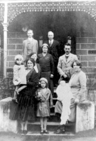
Photograph, Charles Henry Maling and family at 'The Willows', Shepreth Street, Surrey Hills (demolished), 1930s
“The Willows” home of John Butler Maling on south side of Whitehorse Road in Shepreth Street, near Banool Road. He built 2-roomed mud brick cottage in about 1861 extending it in stages into a weatherboard Victorian villa as his family grew. John Butler Maling's uncle (also John Butler Maling lived nearby at 'Ancyra' at 26 Weybridge Street). 'The Willows' was situated on a small farm of c13 acres with a creek running through it, lined with willows. The house was demolished after J B Maling's death in 1931 when the land was subdivided, some of it having been previously bought by the Education Department for the site of Chatham Primary School. J B Maling trained his six sons as builders. Charles Henry and his family are pictured in this photo. Charles Henry Maling (1875-1953) married Katherine Mitchell (1875-1958) in 1901. They lived at 9 Benson Street, Surrey Hills but came to live at 'The Willows' for 5 years prior to 1931 to care for Charles' father. Charles and Katherine are the older man and woman centre back with daughter Ellen Grace, known as Nell (1882-1960) in the front of them. Right front seated on the pillar is daughter Jane Emma (1872-1980) with her baby. Her husband Robert Wilhelm (Bob) Sutherland is the younger man at the back. The occasion is thought to be the christening of their first child. The other people are Rev O Cordell, his wife Mary and their children who are friends visiting from Africa where the donor, Rev Charles Maling, son of Charles Henry Maling was working with the Church Mission Society. A black and white photograph of a group of people standing (one lady sitting) on the front steps of a house.the willows, house names, (mr) john butler maling, whitehorse road, banool road, balwyn, surrey hills, (mr) charles henry maling, (mrs) katherine maling, (miss) nell maling, (mrs) jane sutherland, (mr) bob sutherland, (rev) o cordell, (mrs) mary cordell -
 Surrey Hills Historical Society Collection
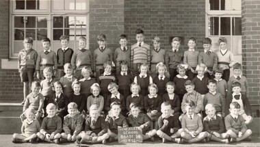
Photograph, Mont Albert Central School Grade 1B, 1953, 1953
Mont Albert State School was officially opened on 23rd April 1917. The school became Mont Albert Central School in 1918, taking in Forms 1 and 2. The school remained a Central School until 1964, when the secondary years formed the basis of a new High School, the Box Hill North High School, later to be named Koonung Secondary College. This is part of a large collection of material related to the Deakin, Mair and Young families, all with connections to Surrey Hills and Mont Albert. Laurie Young was the daughter of Beryl Mair (1916-1976) and Ernest Lance Young (1915-1999). The family lived at 5 York Street and later 11 York Street, Mont Albert. Laurie was born on 18 August 1947. Black and white class photo taken outside the school building. The class of 14 girls and 29 boys. Not all children are wearing school uniform."LY" in grey lead pencil in top RH corner. This probably stands for Laurie Young. Photographer's identification stamp in black ink " L.E. REYNOLDS / PHOTOGRAPHER / 38 RUSSELL STREET, / SURREY HILLS, E10"mont albert central school, laurie young, laurie newton, education