Showing 124167 items
matching main-road
-
 Kew Historical Society Inc
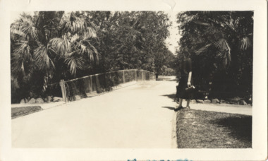
Photograph - In the 'Alexandra Gardens', Kew, 1927
The Alexandra Gardens in Cotham Road, Kew were opened by the Governor of Victoria in 1910. The first curator of the gardens was George Pockett, who with his brother is credited with the layout of the gardens. The gardens were constructed on land originally owned by the King family of 'Madford' in Wellington Street. The land on which the gardens were developed was originally the back paddock of 'Madford' which was purchased by the Borough of Kew in 1906.A rare and early photograph of the gardens showing clearly the changes to the layout and planting during the 1920s. Small, sepia coloured photographic positive of a woman standing beside a path and bridge in the Alexandra Gardens in Cotham Road, Kew.Annotation verso: "Alexandra Gardens Kew 1927"parks and gardens -- kew (vic.), alexandra gardens -- kew (vic.), george pockett -
 Whitehorse Historical Society Inc.
Document, Villa Residence, 11/12/1937 12:00:00 AM
Auction brochure for 'beautiful modern brick villa residence', with 4 1/4 acres of land, Mitcham Road Mitcham, Saturday December 11 1937.Auction brochure for 'beautiful modern brick villa residence', with 4 1/4 acres of land, Mitcham Road Mitcham, Saturday December 11 1937, under instructions from the executors of the estate of the late E. E. Walker. Frontages to Mitcham Road, Delhi Street and Agra Street. Auctioneers: Baillieu Allard in conjunction with Drake & Co. Original copy framed, located in Map Drawer.Auction brochure for 'beautiful modern brick villa residence', with 4 1/4 acres of land, Mitcham Road Mitcham, Saturday December 11 1937.walker, edgar edwardes, walker estate, mitcham road, mitcham, delhi street mitcham, agra street, mitcham, drake & co., baillieu allard pty ltd -
 Kew Historical Society Inc
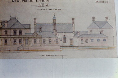
Slide - Architectural Drawing, Kew Public Offices, 1887
A civic campaign for new public offices developed in Kew in the 1880s. After much deliberation, the location chosen was the junction of Bulleen and Cotham Roads. The buildings were designed by George Watson and John Henry Harvey, architects within the Department of Public Works (Victoria). Building was commenced in 1887, and after one year, the buildings were opened. The Post Office was transferred to the new Commonwealth Government in 1901. The Police Station and Court House, sold by the Victorian Government to the City of Boroondara in 2007, are now a community cultural centre and performing arts venue.The buildings were listed on the Victorian Heritage Register Register (HO885) in 1991. They are historically and architecturally significant to the State Of Victoria because Watson and Harvey's designs exhibit diversity in integrating civil offices, they accommodate the apex of road junctions, and they demonstrate a departure from the contemporaneously favoured High Victorian Classical to the Queen Anne style in the design of civic buildings. 35mm colour transparency of an original plan by George Watson and John Henry Harvey, architects of the Department of Public Works (Victoria), in 1887 for New Public Offices at Kew. This plan was copied by the donor from an original held at the Commonwealth Archives in Brighton (Vic). The copy was made to illustrate a report that the donor made on ‘The functional planning design, building materials and construction methods of the Kew Post Office’ as part of course work at RMIT.NEW PUBLIC OFFICES KEW / SCALE 8 FEET TO ONE INCH / COTHAM ROAD ELEVATIONkew court house, kew police station, kew post office, architectural drawings, khs - slides, new public offices -- kew (vic.), architecture — queen anne style -
Glen Eira Historical Society
Letter - Kooyong Road, 415, Elsternwick
Two items about valuation of this property: 1/Typed letter dated 28/01/1977 from the Perpetual Executors and Trustees Association fo Australia Limited by Trust Officer RM Morrison to WV Scott of SP Simmond’s estate agents regarding the report and evaluation for the Sir Hugh Gerner Brian estate located at 415 Kooyong Road Elsternwick, included certificate of title. 2/Copy of typed letter by valuator WV Scott with details of the external and internal condition and valuation of the property with handwritten note,s dated 08/02/1977.kooyong road, elsternwick, brain hugh gerner sir, brain lady, land values, brick houses, bluestone -
Glen Eira Historical Society
Article - Shoobra Road, 86, Elsternwick, 'Andermatt'
Three items on 86 Shoobra Road: 1/ A newspaper advertising article for the forthcoming sale, one on 1/11/2001and one on 14/07/2003 from the Property Review Weekly. It gives an overview of house interior and architectural feature of home. Estate agents nominated to sell property were Wilson Pride. 2/ Advertisement of 14/07/2003 Melbourne Weekly Bayside 3/ Handwritten research by Claire Barton dated 4/09/2012 from Sands and McDougall's Directories 1910, 1913, 1923, 1942, 1948 and 1960.shoobra road, elsternwick, biggin & scott, edwardian style, verandahs, architectural features, real estate agents, ceiling roses, fireplaces, wilson pride, stefanis angela, stefanis angelos, woolcock albert j, 'andermatt', house names -
Glen Eira Historical Society
Letter - ELSTERNWICK BAPTIST CHURCH, GLEN HUNTLY ROAD, 481, ELSTERNWICK
Two letters about the Anderson Organ at this Baptist Church: Photocopied letter dated 05/11/1990 from the National Trust Victoria, advising the City of Caulfield that the Anderson organ at the Baptist Church, 481 GlenHuntly Road, has been placed on the Trusts register, and classified to be preserved. Includes information about organ, organ builder, and organ’s previous history from 1882 to 1990. Email query of 14/02/2012 between Ann Gibson of the National Trust (Aust) & John Maidment about this organ now situated at Flinders.national trust of australia, national trust register, anderson organ, wight ian, dhurringile, pto, baptist church, anderson william murchison, glenhuntly road, organ, winter james, elsternwick, presbyterian church, maidment john, gibson ann, st. johns anglican church, flinders, barton claire -
Glen Eira Historical Society
Article - Shoobra Road, 47, Elsternwick
Two items about this property. A newspaper article from Melbourne Weekly dated 09/05/2012. Article gives brief history on home owners and interior design features. Includes seven colour photographs of mansion. Handwritten notes taken from Sands and MacDougall on 47 Shoobra Road from editions 1910, 1913,1923,1942,1948 and 1960, gives occupiers name changes over the years. No mention of any Chinese owners despite claim in Melbourne Weekly Bayside of 09/05/2012. Researched by Claire Barton, 22/05/2012.chinese community, market gardens, victorian style, deeside, house names, architectural features, gardens, mantle pieces, towers, ceiling rises, shoobra road, elsternwick, biggin and scott, marble, balconies, fireplaces, real estate agents, clerehan neil, keighery kay, cast iron work, richard fred w., graydon n.e., graydon alice mrs., graydon c.w. -
Glen Eira Historical Society
Letter - Elmhurst, Alma Road, Caulfield North
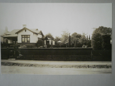
A black and white photograph (130mm x 180mm) of the exterior of the house Elmhurst on Alma Road, Caulfield North with Douglas Keep, Joan Keep, A E Keep, Mrs Keep and Miss Earle pictured in front of the house. The photograph is undated and unattributed. The file also includes a one page letter from Douglas Keep to the Caulfield Historical Society, dated 18/12/1972, referring to Elmhurst and other large homes in Caulfield. The Historical Society’s one page reply to Douglas Keep, dated 05/01/1973, is also included in the file.elmhurst, alma road, caulfield north, caulfield, keep albert e, keep douglas p, king r m, architects, keep joan, governess, earle miss, keep mrs, dandenong road, filbert street, caulfield south, caulfield historical society, mansions, architectural styles -
 Glen Eira Historical Society
Letter - Eskdale Road, 90, Caulfield North
A one page handwritten letter from Alan Douglas to the Glen Eira Historical Society, dated 19/02/04, regarding his donation of eleven professional photographs of the interior, exterior and garden at 90 Eskdale Road, Caulfield, taken by Muntz Studios, possibly in the 1920s. The letter also provides brief details of ownership of the property. Also included is a one page typed reply from the Glen Eira Historical Society, dated 23/03/2004. The file also includes the eleven black and white photographs (130mm x 202mm) of the property.jones james norman, jones winifred gardner, davies winifred, eskdale road, caulfield, caulfield north, douglas alan, douglas barbara kathleen, livingstone-muntz d, muntz studios pty ltd -
Glen Eira Historical Society
Document - Brady Road, 10, Bentleigh East
A one page copy of a typed letter, dated 18/04/1979, from S P Simmonds to tenant J H W Sims requesting access to the property at Brady Road, 10, Bentleigh East for the purposes of conducting a valuation. The file also includes a two page copy of a typed letter, dated 27/04/1979, from valuator W V Scott to Smith and Emmerton Solicitors, providing the valuation of the property. The file also includes one page of handwritten working notes for the purposes of the valuation, dated 25/04/1979.sims j h w, moorabbin heights state school, moorleigh high school, bignell road, maxted mrs, maxted judy -
 Greensborough Historical Society
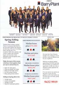
Advertising Leaflet, Barry Plant Bundoora, Barry Plant Spring selling season, 2018_08
Spring selling season leaflet with sales results on back of page. 4 Murumba Street Greensborough, sold $1,115,000 ; 11 Sun Orchid Circuit St Helena sold $870,00; 6 Weemala Court Greensborough sold $1,666,000; 6 Howard Street Greensborough sold $737,000; 136 Elder Street Greensborough sold $772,000; 140 Mountain View Road Briar Hill sold $638,000 and 12 Sunrise Drive Greensborough sold 2018 for $1,320,000, previous sales January 1994 $103,000, July 1989 $100,000 and July 1988 $85,500.Real estate advertising leaflet, 1 sheet, printed in colour on both sides.sunrise drive greensborough, murumba street greensborough, sun orchis circuit st helena, elder street greensborough, howard street greensborough, mountain view road briar hill, weemala court greensborough -
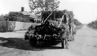 Surrey Hills Historical Society Collection
Photograph, Mr Wally Ives' car decorated for Empire Day, 1935, 1935
Wally Ives was a fruiterer who had a shop in Union Road. He was an active participant in the Empire Day parades of the 1930s. The donor Jean Boucher was the daughter of Wally Ives. She was an early active member of the History Nook at the Surrey Hills Neighbourhood Centre and member of the Surrey Hills Historical Society. The Oakland Motor Car Company was based in Pontiac, Michigan and was a division of General Motors. Although it was purchased by General Motors in 1909, the company continued to produce modestly priced automobiles until 1931 when the brand was dropped in favour of the division's Pontiac make. B&W photo of a decorated vehicle (Oakland car) parked in a street without kerbs or guttering. There is a Victorian-style house in the background.38. in black pen in top LH corner.(mr) wally ives, transport, croydon road, empire day, festivals and celebrations, oakland car, cars -
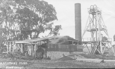 Ringwood and District Historical Society
Photograph, Antimony Mine, Ringwood 1920
Black and white photograph showing mine building and poppet head. Gum trees to left of picture. (3 copies, various sizes)Typed below photograph, "Antimony Mine, Ringwood - 1920". Catalogue card reads, "Main antimony mine, 1920. Now Civic Centre site. Mullock heaps ("tailings") around place used extensively in making roads in Ringwood in early days." -
Glen Eira Historical Society
Book - St. Mary’s Church, Caulfield
Two copies of St. Mary’s Anglican Church, Glen Eira Road, Caulfield. Souvenir of 50 years 1858-1908. Includes history of the church, home and foreign missions, list of memorials and gifts in the church. Also photos of parishioners the church and interior, the vestry and Rev. A.J.H. Priest and Mrs. Priest, and Rev. H.B. Macartney and Mrs. Macartney. Two copies of St. Mary’s Anglican Church, Glen Eira Road Caulfield. Souvenir record of 60 years 1858-1918. Includes history of the wooden church, names of the early parishioners, the first, third and fourth incumbencies, the jubilee school, Sunday school, choir and organ, daughter churches and St. Mary’s a mission parish, and the last decade from 1908 to 1918. It also has a list of organisations and office bearers. Manila book has all photos omitted. There are twelve photos including St. Mary’s choir, a group of St. Mary’s Sunday school teachers, missionaries, curate, organist and verger, Rev. H.T. Langley and Mrs. Langley. Three leaflets from St. Mary’s Church, the first 100 years of the church building 1871-1971. Leaflets detail the centenary services and functions. It has a list of office bearers and vicars, named windows, the honour roll and some other notable areas in the church and furniture.watts thomas, caulfield, glen huntly road, balaclava, hawthorn road, the black chapel, st. mary’s, park street, porter mrs., pennington mr., pennington mrs., stephen wilberforce, stephen mrs., hart mrs., cox peter, bunton barbara -
Whitehorse Historical Society Inc.
Document, Sylvia's memory gem
Sylvia Pilven, who is a local resident, relates stories of her life to Dorothy Williams.Sylvia Pilven, who is a local resident, relates stories of her life to Dorothy Williams. She was the last of the Williamson Family and lived to 98, dying in 1907. The Williamson family property was in Mt Pleasant Road TunstallSylvia Pilven, who is a local resident, relates stories of her life to Dorothy Williams. williamson, alfred, williamson, isabella, mount pleasant road tunstall -
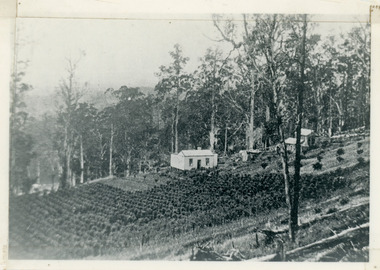 Mt Dandenong & District Historical Society Inc.
Photograph, Harry Walker's Home in Village Settlement 1908, c1908
View of Harry Walker's home taken from waht is now known as Ridge Road, Kalorama. Raspberry crops are in the foreground. This photograph has a detailed inscription on the back handwritten by John Lundy-Clarke in 1974.1908 view of H Walker’s home on Village Settle Lot 2 Section 1. Looking from what is now Ridge Road through the trees on Vil. Set Lot 18 to Barber’s house now known as “Forest Edge” on Vil Set Lot 25 down close to the Olinda Creek on Barbers Road. The Estate Agent’s modern office is on the edge of the patch of raspberries at the lower left as the C.R.B. Mt Dandenong Rd passes just behind Walker’s house crossing the picture behind the raspberries.walker, raspberry crop, forest edge, barber -
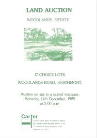 Ringwood and District Historical Society
Pamphlet - Land Sales Brochure, Woodlands Estate, Heathmont, 1985
Bifold pamphlet with picture on front, one inside plus plan of Woodlands Road sub division and locality plan on back page. All in green print. Copy enclosed with handwritten sale prices. Auctioneer's notes (Richard Carter) indicate vendor - Estate of Phoebe Beard.Auction on site in a seated marquee, Saturday 14th December, 1985. Agent - C.E. Carter & Son Pty. Ltd., 122 Whitehorse Road, Ringwood, 3134. Telephone 870 6211. -
 City of Kingston
Pamphlet - Colour, R. Malcolm Estate Agents et al, Last Chance Land Sale Heritage Estate Cheltenham, c.1994
Sales plan for land in the suburb of Cheltenham, bounded by Chesterville Road and Bernard Street, and incorporating Clendon Court, Tintern Grove and Tintern MewsThis land sale pamphlet illustrates one of the last subdivisions of the century in Cheltenham, incorporating house and land packages. It shows that land sales and subdivision for the area had slowed considerably by the end of the 1900s and that the infrastructure was significantly developed. Colour pamphlet advertising last chance land sale of Heritage Estate Cheltenham. Incorporates a map of the estate bordered by Chesterville Road and Bernard Street, and including Clenton Court, Tintern Grove and Tintern Mews.cheltenham, land sales, estate -
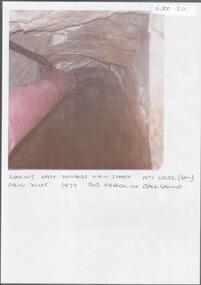 Bendigo Historical Society Inc.
Photograph - KEN BICE COLLECTION: WATTLE GULLY GOLD MINE
Colour photograph, faded and laminated. Image shows an underground tunnel with air/electricity wiring on LH side of decline. Written on bottom : looking east towards main shaft. No. 1 level (60m) main xcut 1979. Bob Farrell in background'mining, underground equipment, wattle gully gold mine -
Whitehorse Historical Society Inc.
Article, Rezoning outrage, 22/09/1992 12:00:00 AM
Nunawading Council outraged by State Government's shock decision to immediately rezone land in the Eastern Arterial Road corridor without public consultation.Nunawading Council outraged by State Government's shock decision to immediately rezone land in the Eastern Arterial Road corridor without public consultation. The decision means the land set aside for the Eastern Arterial Road will be immediately rezoned to public open space by ministerial amendment jeopardising any future moves to construct the entire freeway. Council are considering Supreme Court action to stop the rezoning.Nunawading Council outraged by State Government's shock decision to immediately rezone land in the Eastern Arterial Road corridor without public consultation. local government, city of nunawading, eastern freeway, koonung mullum forestway association, mullum mullum creek -
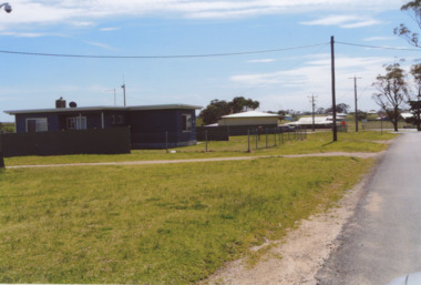 Lakes Entrance Historical Society
Photograph - Lake Tyers Aboriginal Trust Lake Tyers Victoria, 1/08/2008 12:00:00 AM
Rules Road at the Lake Tyers Aboriginal Trust Lake Tyers Victoria. This photograph was taken at the time of 150 years Lakes Entrance 1858 to 2008 display held in 2008Colour photograph of houses on Rules Road at the Lake Tyers Aboriginal Trust Lake Tyers Victoria. plus 2 other photos of the Lake Tyers Aboriginal Trust Lake Tyers Victoria.aboriginals, land settlement, events, houses -
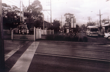
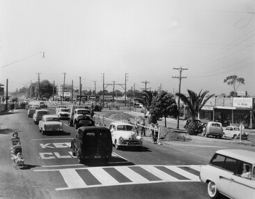 City of Kingston
Photograph - Black and white, c. 1957
Copy black and white photograph of railway level crossing on Nepean Highway Moorabbin before excavations for the below ground rail crossing. The level crossing gates are closed and five cars are waiting, while other cars can be seen coming in the opposite direction. A woman with a child in a pram is walking along the road, and a number of men, probably construction workers, are standing behind a barricade on the right hand side of the road. Gilbey's Gin distillery is visible in the background. TCopy black and white photograph of railway level crossing on Nepean Highway Moorabbin before excavations for the below ground rail crossing. The level crossing gates are closed and five cars are waiting, while other cars can be seen coming in the opposite direction. A woman with a child in a pram is walking along the road, and a number of men, probably construction workers, are standing behind a barricade on the right hand side of the road. Gilbey's Gin distillery is visible in the background. Handwritten in blue ink on reverse: 57-465C Handwritten in red ink on reverse: 71% A red circle has been drawn around all handwritten text.moorabbin, railway station, railway crossing, suburbs, cars, local production -
 Orbost & District Historical Society
black and white photograph, February 1971
This photograph was taken near the Snowy River Bridge on the the old Princes Highway in Orbost, near the caravan park. The 1971 flood was the the worst flood on record. At Jarrahmond it was at least 11 metres and up to one and a half kilometres wide on the flats causing enormous damage to the flood plain. Records say that "The brown floodwater stain in Bass Strait could be seen from passing airliners." Considerable damage was done to railway infrastructure, roads and farms. More information from the APRIL, 2008 newsletter by John Phillips. (see orbosthistory.com.au)This is pictorial evidence of a significant local event. Floods have been an integral part of Orbost's history for hundreds of years.A black / white photograph of debris, fallen power lines, a tree across the highway and floodwaters across the road.on front at bottom - handwritten in upper case print - " 1971 FLOOD PRINCES HIGHWAY NEAR SNOWY BRIDGE"floods-orbost-1971 -
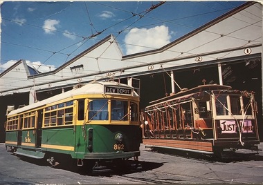 Kew Historical Society Inc
Postcard, Biscay Greetings Pty Ltd, Trams at Kew Depot, c.1991
The Kew tram depot is located on the corner of Barkers Road and High Street, Kew. It is one of eight tram depots on the Melbourne tram network. The depot opened on 8 May 1915. The main yard has 12 covered roads. There are two tracks for trams leaving or entering via Barkers Road, and a single track connecting to High Street.Postcard produced c.1991 to commemorate 75 Years of Service of The Kew Depot (1915/16-1991). The postcard shows two trams at the depot. The details are included in the information provided on the reverse.Kew Depot is ready for work W Class 892 waits for its next duty while visiting V Class 214 is ready for special work Photo by R. J. Marsh T101 Copyright Biscay Greetings Pty Ltd Telephone (03) 562 3599tramways - kew, kew tramways depot, -
 Whitehorse Historical Society Inc.
Photograph, Pedestrian Crossing & Nunawading Railway Station, 1/06/2009
One of a collection of photographs taken of the Nunawading Railway Station prior to the lowering of the railway line and building of the new railway station on the western side of Springvale Road so that the Springvale Road Rail Crossing can be eliminated.Black & white photograph of the precinct surrounding the Nunawading Station and the Springvale Road Railway crossing. This photograph is looking over the south side of the intersection in Springvale, to the pedestrian crossing and the Railway Station. The shopping centre is on the right hand side. See NP 3545 to NP3567 for the complete set of photographsnunawading railway station, springvale road nunawading, redevelopment of railway line/springvale road. -
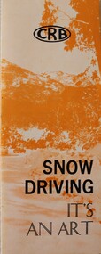 Falls Creek Historical Society
Booklet - Snow Driving - It's an Art
This brochure was produced by the Country Roads Board in 1976. It became the Board's most popular driver education publication. The brochure was reprinted after requests for 20,000 copies were received from interested authorities and individuals. A revised addition was released in 1978.This document is significant because it documents approaches taken towards safety as the ski fields became more popular, An orange and white brochure with black text. Produced by the Country Roads Board, it aims to educate the public about appropriate driving behaviours and precautions for driving in snow conditions.CRB Snow Driving - It's an Artcountry roads board, road safety, driving in snow conditions -
 Melbourne Tram Museum
Postcard - Nu-color-Vue - St Kilda Road, Shrine of Remembrance W2 453, Nucolorvue Publishing, 1970s
Postcard - image looking south in St Kilda Road, with the Shrine of Remembrance and BP House in the view. Tram W2 453 (City Route 6) and SW6 945 (Camberwell Route 72) has stopped at the safety zone tram stop.Demonstrates an iconic Melbourne image, St Kilda Road, the Shrine and W class tramsPostcard colour - serrated edge, Nu-color-Vue - St Kilda Road, Shrine of Remembrance W2 453, ML 156, NCV 1381 Divided back.trams, tramways, w2 class tram, shrine of remembrance, tram 453, st kilda road, tram 945 -
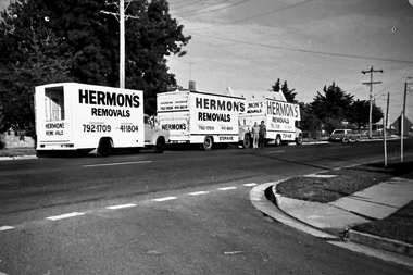 Southern Sherbrooke Historical Society Inc.
Photograph - Set of photos pertaining to Hermon's Removals, c. 1980s
Set of photos from c. 1980s pertaining to Hermon's Removals. William (Bill) Hermon Junior established a furniture removals business in 1935. Their depot was on the corner of Main Rd and Snodgrass St, Pakenham. When Bill's younger sons Ken and Ron, acquired the business in 1994 the business was renamed Hermon's Rainbow Removals, which remains in operation today. 1. Photograph of 3 trucks from Hermon's Removals on Main Road, Pakenham, down near McGregor Rd. Their depot was on the corner of Main Rd and Snodgrass St, Pakenham. 2. Photograph of one of Hermon's Removal trucks at Pakenham. 3. A photograph featuring three of Hermon's Removal Trucks lined up on a suburban street. 4. A photograph featuring Bill Hermon (second from the right of picture) and his sons, Ron, John and Ken. -
Whitehorse Historical Society Inc.
Map, Aerial photograph, c1950
Arial photo of Vermont South and Burwood East, Middleborough Road, Burwood Highway, Springvale Road, Highbury Road and environs.Aerial photo of Vermont South and Burwood East, Middleborough Road, Burwood Highway, Springvale Road, Highbury Road and environs.Arial photo of Vermont South and Burwood East, Middleborough Road, Burwood Highway, Springvale Road, Highbury Road and environs.vermont south, burwood east, aerial photographs -
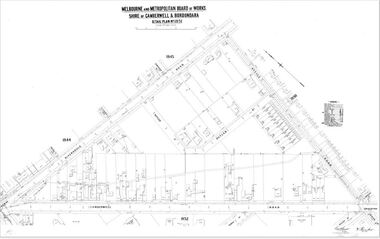 Camberwell Historical Society
Map (Item) - MMBW map, Melbourne and Metropolitan Board of Works, Melbourne and Metropolitan Board of Works - Shire of Boroondara and Camberwell - Detail Plan no. 1851, July 1904
Lithographer JEM, exd. JWD, July 1904, no. 81, 40P. 15W.melbourne and metropolitan board of works, map, camberwell, cartography