Showing 3693 items matching "current"
-
 Rutherglen Historical Society
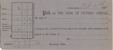
Financial record - Bank deposit slip, 31/10/1915 (Exact)
There is no information on the name of the depositor. Part of a collection of business documents found under the floor of a building in Main Street when it was being renovated. At that time the owner was Don Chambers, and the premises was occupied as the Chambers Riteway Supermarket. The location (134 Main Street) is currently (2022) occupied by Miegel’s Pharmacy Rutherglen. Bank of Victoria, Rutherglen deposit slip printed on both sides, on grey paper, with date and figures in pencilDate: "Oct 31st 1915" Receiving teller initials: "SB"bank of victoria, banking, bank deposit, 134 main street, chambers riteway supermarket -
 Vision Australia
Text, Newspaper clippings 14 (1983-1991), 1983-1991
To keep current with media articles on how vision impaired people, blindness organisations and their activities were reported in the press, books of newspaper cuttings were created. News stories were taken from local, regional and national papers covering a variety subjects. Loose articles at front of folder.1 brown folder with newspaper cuttingsassociation for the blind -
 Melbourne Tram Museum
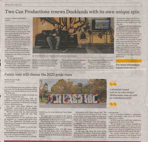
Newspaper, Carol Saffer, Public vote will choose the 2023 Pride tram, Oct. 2022
News item titled " Public vote will choose the 2023 Pride tram" discussing the process for voting for the 2023 Pride tram, the prize money and timing. Quotes Yarra Trams CEO Julien Dehornoy. Has a photo of the current tram "AllAboard", a D Class tram. Written by Carol Saffer.Yields information about the selection of a wrap for the 2023 Pride Tram.Newspaper sheet - full colour - from "The Voice of Postcode 3008" - page 9 - October 2022transporting art, pride tram, yarra trams, decoarated trams -
 Eltham District Historical Society Inc
Audio - Audio Recording, Audio Recording; 2019-04-10 AGM and Eltham Cemetery Trust with Julia Drew, 10 Apr 2019
April Meeting (Newsletter No. 245, Apr. 2019) At this meeting we are pleased to have as our guest speaker a representative from the Eltham Cemetery Trust, who will talk about their connections to our local history and how current practices and projects continue to support the artistic connections in the Eltham region.1:11:42 duration Digital MP3 File 24.6 MB audio recording, eltham cemetery trust, eltham district historical society, julia drew, meeting, society meeting -
 Eltham District Historical Society Inc
Audio - Audio Recording, Audio Recording; 2019-08-14 Street Lotto with Jim Connor, the story behind some of Eltham's street names, 14 Aug 2019
April Meeting (Newsletter No. 245, Apr. 2019) At this meeting we are pleased to have as our guest speaker a representative from the Eltham Cemetery Trust, who will talk about their connections to our local history and how current practices and projects continue to support the artistic connections in the Eltham region.1:11:42 duration Digital MP3 File 24.6 MB audio recording, eltham, eltham district historical society, jim connor, meeting, society meeting, street names -
 Warrnambool and District Historical Society Inc.
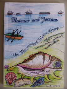
Book, Flotsam and Jetsam, 2014
This is an anthology of writings by members of the Warrnambool Writers’ Group. The group was formed nearly 30 years ago and has published several other anthologies. The book contains writings from current members of the group and many contributions contain reference to Warrnambool’s maritime and township history and present day affairs. The book is of some significance as the contents are by local people and refer not only to their personal thoughts and ideas but also to aspects of Warrnambool’s past and current situation. It has, therefore, social and cultural significance. This is a paper-back book of 85 pages. The cover is multi-coloured with a seascape design on the front cover and printed material on the back cover. The inside pages contain printed material only with a sketch of a boat on the frontispiece. The pages have been bound with glue. Front Cover: ‘Flotsam and Jetsam’, The Warrnambool Writers’ Group, Anthology 2014, © SM 160413’warrnambool, poetry and short stories -
 Ringwood and District Historical Society
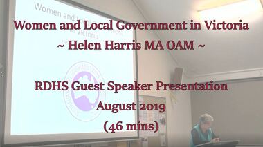
Mixed media - Video, RDHS Guest Speaker Presentation - Women in Local Politics - Helen Harris MA OAM
Digitised video (1.97GB). Duration: 46 minutes. Recorded August, 2019 (Video is available for viewing at Ringwood & District Historical Society Archives by appointment)Helen Doxford Harris is a professional genealogist and historian of more than thirty years standing. Her interest in history was first developed when she commenced researching her family history. She has written many texts on various subjects relating to Victoria Police, the Indigenous and women’s fields of study. Helen is also current Secretary of Box Hill Historical Society. In this presentation, Helen presents a great talk on Women in Politics, highlighting the difficulty in achieving equality in representation on the political stage. -
 Warrnambool and District Historical Society Inc.
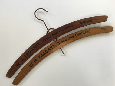
Coat Hanger, W. H Taggart Tailor & Outfitter
W J Taggart was a tailor who operated from Fairy Street at the time near Russell’s and Powell’s. This is near The Caledonian Hotel and in the current RSPCA shop. They had moved to this shop around 1884. A notice in the local paper in 1922 states that he was re- opening his business in the same premises.Provides a link to one of Warrnambool’s 19th Century businesses.Wooden hangers with rounded corners and metal hooks. Printed names engraved and painted in black with business name.W J Taggart Tailor and Outfitter Warrnambool W H Taggart Tailor and outfitter Warrnambool. Both made in America w j taggart, coathangers, warrnambool -
 Eltham District Historical Society Inc
Audio - Audio Recording, Mark Cauchi; Eltham to Hurstbridge Railway – The line through the valley of the Diamond, 22 Apr 2022
At this meeting we are pleased to have as our guest speaker Mark Cauchi, who is an active railway historian and a long-term member of the former Australian Railway Historical Society. Mark will provide a glimpse into the extension of the railway from Eltham to Hurstbridge, using various historic and current-day railway images.1:18:42 duration Digital MP3 file; 27.0 MBaudio recording, eltham, eltham district historical society, meeting, society meeting, agm, hurstbridge line, mark cauchi, railway line -
 Greensborough Historical Society
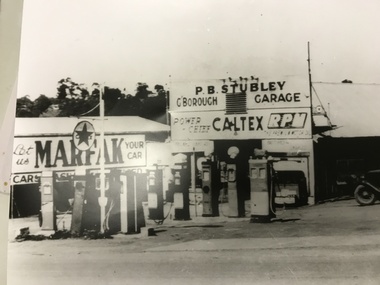
Photograph, Stubley's Garage, 1948c
Purcell Stubley bought the garage site in 1946, and this photograph would have been taken shortly afterwards. Note the multiple fuel bowsers, each selling a different brand. Watson Holden was on this site until the late 1970's. Then Woolworths constructed the current building which Savers now occupy. Part of a collection of photographic enlargements of Greensborough sites.Black and white enlargement of photographic imagestubley motors, main street greensborough, woolworths greensborough, watson holden, savers -
 Kiewa Valley Historical Society
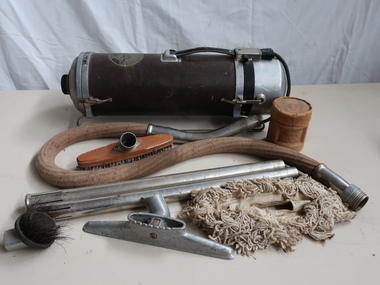
Vacuum Cleaner - Electrolux
Vacuum cleaners have been part of the household for many years. Beginning as simple tools blowing the dust to the current sucking up the dust and being powered by electricity. From the shape of a barrel to those that stand upright, from being fitted onto a 'sled' to those with wheels and from heavy to light.Used by a resident in the Kiewa Valley Electrolux cannister steel vacuum with leather handle at the top, the electric socket (and cut power cord attached) at one end and the cloth covered hose at the other end. Two steel extension handles, hose and cord works. Parts with combination dusting and upholstery tool and hardwood floor dust mop and refrigerator crevice tool. The cannister sits on a 'sled' of two long rods on each side.Hand written on the cannister "1932 Model" "Electro / lux / Made in Sweden / Design Nr B156 Registered" on top On bottom "Ser 1234 No. 1456 / Volt Watt" ....(not legible)electrolux, vacuum cleaner 1932 -
 St Kilda Historical Society
Photograph - Photo map, 28/01/1951
One of a series of photo-maps produced for the Department of Crown Lands and Survey (1857-1983). For correlation with a current map, and access to other historical photo maps of Victoria, see the Historic Photo-Maps Index published by the Department of Environment, Land, Water and Planning at https://services.land.vic.gov.au/DELWPmaps/historical-photomaps/Black and white aerial photograph1424-45 SECRET 534 Run 18 Lens 12" Melbourne Metropolitan 12150 28.1.51 M639albert park, st kilda junction, st kilda pier, catani gardens, st kilda, prahran, albert park lake, 1951, middle park, st kilda beach, windsor -
 St Kilda Historical Society
Photograph - Photo map, 17/01/1951
One of a series of photo-maps produced for the Department of Crown Lands and Survey (1857-1983). For correlation with a current map, and access to other historical photo maps of Victoria, see the Historic Photo-Maps Index published by the Department of Environment, Land, Water and Planning at https://services.land.vic.gov.au/DELWPmaps/historical-photomaps/Black and white aerial photograph1414-21 538 Run 19 Lens 12" Melbourne Metropolitan 12150 17.1.51 M586st kilda, st kilda botanical gardens, peanut farm, elwood, 1951, point ormond, elwood canal, st kilda beach -
 St Kilda Historical Society
Photograph - Photo map, 28/01/1951
One of a series of photo-maps produced for the Department of Crown Lands and Survey (1857-1983). For correlation with a current map, and access to other historical photo maps of Victoria, see the Historic Photo-Maps Index published by the Department of Environment, Land, Water and Planning at https://services.land.vic.gov.au/DELWPmaps/historical-photomaps/Black and white aerial photograph1424-118 534 Run 20 Lens 12" Melbourne Metropolitan 12150 18.1.51M639elwood, point ormond, elwood park, elsternwick park, elwood beach, 1951 -
 St Kilda Historical Society
Photograph - Photo map, 17/01/1951
One of a series of photo-maps produced for the Department of Crown Lands and Survey (1857-1983). For correlation with a current map, and access to other historical photo maps of Victoria, see the Historic Photo-Maps Index published by the Department of Environment, Land, Water and Planning at https://services.land.vic.gov.au/DELWPmaps/historical-photomaps/Black and white aerial photograph1414-20 538 Run 19 Lens 12" Melbourne Metropolitan 12150 17.1.51 M586elwood, elsternwick, st kilda east, balaclava, ripponlea, 1951 -
 St Kilda Historical Society
Photograph - Photo map, 28/01/1951
One of a series of photo-maps produced for the Department of Crown Lands and Survey (1857-1983). For correlation with a current map, and access to other historical photo maps of Victoria, see the Historic Photo-Maps Index published by the Department of Environment, Land, Water and Planning at https://services.land.vic.gov.au/DELWPmaps/historical-photomaps/Black and white aerial photograph1424-44 534 Run 18 Lens 12" Melbourne Metropolitan 12150 28.1.51 M639 -
 St Kilda Historical Society
Photograph - Photo map, 28/01/1951
One of a series of photo-maps produced for the Department of Crown Lands and Survey (1857-1983). For correlation with a current map, and access to other historical photo maps of Victoria, see the Historic Photo-Maps Index published by the Department of Environment, Land, Water and Planning at https://services.land.vic.gov.au/DELWPmaps/historical-photomaps/Black and white aerial photograph1424-43 534 Run 18 Lens 12" Melbourne Metropolitan 12150 28.1.51 M639armadale, malvern, st kilda cemetery, caulfield north, st kilda east, 1951 -
 St Kilda Historical Society
Photograph - Photo map, 30/01/1960
One of a series of photo-maps produced for the Department of Crown Lands and Survey (1857-1983). For correlation with a current map, and access to other historical photo maps of Victoria, see the Historic Photo-Maps Index published by the Department of Environment, Land, Water and Planning at https://services.land.vic.gov.au/DELWPmaps/historical-photomaps/Black and white aerial photographVic 1093-62 Melbourne & Metropolitan Project Run 21 30.1.60 Lens 10" 8.200middle park, albert park, catani gardens, st kilda west, 1960 -
 St Kilda Historical Society
Photograph - Photo map, 30/01/1960
One of a series of photo-maps produced for the Department of Crown Lands and Survey (1857-1983). For correlation with a current map, and access to other historical photo maps of Victoria, see the Historic Photo-Maps Index published by the Department of Environment, Land, Water and Planning at https://services.land.vic.gov.au/DELWPmaps/historical-photomaps/Black and white aerial photographVic 1093-60 Melbourne & Metropolitan Project Run 21 30.1.60 Lens 10" 8.200st kilda, albert park, prahran, windsor, south yarra, 1960 -
 St Kilda Historical Society
Photograph - Photo map, 30/01/1960
One of a series of photo-maps produced for the Department of Crown Lands and Survey (1857-1983). For correlation with a current map, and access to other historical photo maps of Victoria, see the Historic Photo-Maps Index published by the Department of Environment, Land, Water and Planning at https://services.land.vic.gov.au/DELWPmaps/historical-photomaps/Black and white aerial photographVic 1092-36 Melbourne & Metropolitan Project Run 22 30.1.60 Lens 10" 8.200st kilda, st kilda pier, st kilda beach, catani gardens, 1960 -
 St Kilda Historical Society
Photograph - Photo map, 30/01/1960
One of a series of photo-maps produced for the Department of Crown Lands and Survey (1857-1983). For correlation with a current map, and access to other historical photo maps of Victoria, see the Historic Photo-Maps Index published by the Department of Environment, Land, Water and Planning at https://services.land.vic.gov.au/DELWPmaps/historical-photomaps/Black and white aerial photographVic 1092-38 Melbourne & Metropolitan Project Run 22 30.1.60 Lens 10" 8.200st kilda, st kilda beach, st kilda pier, catani gardens, 1960, st kilda botanical gardens, peanut farm -
 St Kilda Historical Society
Photograph - Photo map, 30/01/1960
One of a series of photo-maps produced for the Department of Crown Lands and Survey (1857-1983). For correlation with a current map, and access to other historical photo maps of Victoria, see the Historic Photo-Maps Index published by the Department of Environment, Land, Water and Planning at https://services.land.vic.gov.au/DELWPmaps/historical-photomaps/Black and white aerial photographVic 1092-40 Melbourne & Metropolitan Project Run 22 30.1.60 Lens 10" 8.200st kilda east, balaclava, ripponlea, st kilda cemetery, 1960 -
 St Kilda Historical Society
Photograph - Photo map, 30/01/1960
One of a series of photo-maps produced for the Department of Crown Lands and Survey (1857-1983). For correlation with a current map, and access to other historical photo maps of Victoria, see the Historic Photo-Maps Index published by the Department of Environment, Land, Water and Planning at https://services.land.vic.gov.au/DELWPmaps/historical-photomaps/Black and white aerial photographVic 1092-42 Melbourne & Metropolitan Project Run 22 30.1.60 Lens 10" 8.200malvern, caulfield, caulfield park, 1960 -
 St Kilda Historical Society
Photograph - Photo map, 30/01/1960
One of a series of photo-maps produced for the Department of Crown Lands and Survey (1857-1983). For correlation with a current map, and access to other historical photo maps of Victoria, see the Historic Photo-Maps Index published by the Department of Environment, Land, Water and Planning at https://services.land.vic.gov.au/DELWPmaps/historical-photomaps/Black and white aerial photographVic 1091-112 Melbourne & Metropolitan Project Run 23East 30.1.1960 Lens 10" 8.200elwood, point ormond, elwood park, elwood canal, 1960 -
 St Kilda Historical Society
Photograph - Photo map, 30/01/1960
One of a series of photo-maps produced for the Department of Crown Lands and Survey (1857-1983). For correlation with a current map, and access to other historical photo maps of Victoria, see the Historic Photo-Maps Index published by the Department of Environment, Land, Water and Planning at https://services.land.vic.gov.au/DELWPmaps/historical-photomaps/Black and white aerial photographVic 1091-110 Melbourne & Metropolitan Project Run 23East 30.1.60 Lens 10" 8.200elwood, elsternwick, elsternwick park, ripponlea, st kilda east, caulfield, balaclava, 1960 -
 St Kilda Historical Society
Photograph - Photo map, 30/01/1960
One of a series of photo-maps produced for the Department of Crown Lands and Survey (1857-1983). For correlation with a current map, and access to other historical photo maps of Victoria, see the Historic Photo-Maps Index published by the Department of Environment, Land, Water and Planning at https://services.land.vic.gov.au/DELWPmaps/historical-photomaps/Black and white aerial photographVic 1091-1 Melbourne & Metropolitan Project Run 24East 30.1.60 Lens 10" 8.200elwood, elwood beach, elwood park, 1960 -
 St Kilda Historical Society
Photograph - Photo map, 30/01/1960
One of a series of photo-maps produced for the Department of Crown Lands and Survey (1857-1983). For correlation with a current map, and access to other historical photo maps of Victoria, see the Historic Photo-Maps Index published by the Department of Environment, Land, Water and Planning at https://services.land.vic.gov.au/DELWPmaps/historical-photomaps/Black and white aerial photographVic 1091-2 Melbourne & Metropolitan Project Run 24East 30.1.60 Lens 10" 8.200elwood, elwood park, elwood beach, elsternwick park, 1960 -
 St Kilda Historical Society
Photograph - Photo map, 3/3/1964
One of a series of photo-maps produced for the Department of Crown Lands and Survey (1857-1983). For correlation with a current map, and access to other historical photo maps of Victoria, see the Historic Photo-Maps Index published by the Department of Environment, Land, Water and Planning at https://services.land.vic.gov.au/DELWPmaps/historical-photomaps/Black and white aerial photographVic 1833 Melbourne 1963 Project Run 15 3.3.64 Lens 205 152.70 M/M 5.150 56prahran, fawkner park, south yarra, albert park, 1964 -
 St Kilda Historical Society
Photograph - Photo map, 14/12/1963
One of a series of photo-maps produced for the Department of Crown Lands and Survey (1857-1983). For correlation with a current map, and access to other historical photo maps of Victoria, see the Historic Photo-Maps Index published by the Department of Environment, Land, Water and Planning at https://services.land.vic.gov.au/DELWPmaps/historical-photomaps/Black and white aerial photographVic 1807 Melbourne 1963 Project Run 16 14.12.63 Lens 205 152.70 M/M 5.150 179st kilda, prahran, albert park, st kilda east, balaclava, 1963 -
 St Kilda Historical Society
Photograph - Photo map, 14/12/1963
One of a series of photo-maps produced for the Department of Crown Lands and Survey (1857-1983). For correlation with a current map, and access to other historical photo maps of Victoria, see the Historic Photo-Maps Index published by the Department of Environment, Land, Water and Planning at https://services.land.vic.gov.au/DELWPmaps/historical-photomaps/Black and white aerial photographVic 1807 Melbourne 1963 Project Run 16 14.12.63 Lens 205 152.70 M/M 5.150 181st kilda cemetery, caulfield north, st kilda east, armadale, malvern, 1963