Showing 1193 items
matching pipe
-
 Phillip Island and District Historical Society Inc.
Photograph, Family Photographs and Back to Phillip Island
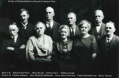
1041-01 Family of Elizabeth Rebecca Bryant & Solomon West - family identified c1924 - ?? 1926 1041-02 Back to Phillip Island c 1924. People identified in 1989 by Mrs Beth Freeman, daughter of William Otway MorrisonHistorical1041-01 Photograph: Family of Elizabeth Rebecca Bryant & Solomon West 1041-02 Photograph: Back to Phillip Island c 1924 with names1041-01: Family of Elizabeth Rebecca Bryant & Solomon West Back L-R Alfred Ernest West, Albert Bryant, Edwin Calver, William Joseph Front L-R Charles Solomon, Alice Elizabeth McDonald, Fanny Maria Morrison, Emily Elizabeth Lock, Harry Thomas 1041-02: Back to Phillip Island c.1924 Identification 1989, Mrs Beth Freeman daughter of William Otway Morrison Front L-R 1. Dan Morrison 2. Ted West 3. Norman McDonald 4. William West s/o Solomon 5. ? 6. William Otway Morrison Second Row L-R 1.? 2. Miriam West Henderson d/o John 3. ? 4. Emily West Lock d/o Solomon 5. ? 6. Fanny West Morrison w/o No. 6 above, d/o Solomon 7. Child to 10 (man with pipe) not identified Back Row L-R 1 to 5 not identified 6. Albert West, s/o Solomon 7. Marion Somerville West 8. Janet Morrison w/o Wm West (obscured) 9. Harry Brown 10. Nell West Brown d/o William West 11-13 unidentified 14. Alice West McDonald d/o Solomon 15. Jenny?west, back to phillip island c1924, morrison family, bryant, solomon -
 Flagstaff Hill Maritime Museum and Village
Container - Bottle, 1840s to 1910
This handmade ‘gallon’ style of bottle was generally used for storing and transporting wine and ale. Many bottles similar to this one have their bases embossed with “6 TO THE GALLON”. However, this bottle is rare, in that the base has been embossed then over-embossed with the same text, letters overlapping. It is one of many artefacts recovered from unidentified shipwrecks along Victoria’s coast between the late 1960s and the early 1970s. It is now part of the John Chance Collection. The capacity of this is one-sixth of a gallon (imperial measure), which is equal to 758 ml. (American bottles were often inscribed “5 TO THE GALLON”, which is one-fifth of an American gallon, equal to 757 ml.) Contemporary home brewers can purchase new ‘6 to gallon’ bottles that hold 750 ml. and are sold in cases of 36 bottles, which is equal to 6 gallons of wine. Glass was made thousands of years ago by heating together quartz-sand (Silica), lime and potash. Potash was obtained from burnt wood, but these days potash is mined. The natural sand had imperfections such as different forms of iron, resulting in ‘black’ glass, which was really dark green or dark amber colour. The ‘black’ glass was enhanced by residual carbon in the potash. Black glass is rarely used nowadays but most beer, wine, and liquors are still sold in dark coloured glass. Glass vessels were core-formed from around 1500 BC. An inner core with the vessel’s shape was formed around a rod using a porous material such as clay or dung. Molten glass was then modelled around the core and decorated. When the glass had cooled the vessel was immersed in water and the inner core became liquid and was washed out. Much more recently, bottlers were crafted by a glassblower using molten glass and a blow pipe together with other hand tools. Another method was using simple moulds, called dip moulds, that allowed the glass to be blown into the mould to form the base, then the glassblower would continue blowing free-form to shape the shoulders and neck. The bottle was then finished by applying a lip. These moulded bottles were more uniform in shape compared to the free-form bottles originally produced. English glassblowers in the mid-1800s were making some bottles with 2-piece and 3-piece moulds, some with a push-up style base, sometimes with embossing in the base as well. Improvements allowed the moulds to also have embossed and patterned sides, and straight sided shapes such as hexagons. Bottles made in full moulds usually displayed seam seams or lines. These process took skill and time, making the bottles valuable, so they were often recycled. By the early 20th century bottles were increasingly machine made, which greatly reduced the production time and cost. This bottle is a rare find, in that the base has been over-embossed with the same lettering, letters overlapping one another. This bottle is historically significant as an example of a handmade, blown inscribed glass bottle manufactured in the mid-to-late 1800s for specific use as a liquor bottle with a set measurement of one-sixth of gallon. It is also historically significant as an example of liquor bottles imported into Colonial Victoria in the mid-to-late 1800s, giving a snapshot into history and social life that occurred during the early days of Victoria’s development, and the sea trade that visited the ports in those days. The bottle is also significant as one of a group of bottles recovered by John Chance, a diver in Victoria’s coastal waters in the late 1960s to early 1970s. Items that come from several wrecks have since been donated to the Flagstaff Hill Maritime Village’s museum collection of shipwreck artefacts by his family, illustrating this item’s level of historical value. Bottle, over embossed, brown glass, handmade, rare. Tall slim Gallon style liquor bottle. Applied double collar lip; square upper and flared lower. Mouth has sealing tape remnants around top. Mould seam around shoulder. Body tapers inwards to push-up base. Top edge of lip has application faults. There is also a rectangular indent in the upper edge of lip. Base is embossed and over embossed, with the letters overlapping each other. Embossed on base "6 TO THE GALLON", then over-embossed with the same "6 TO THE GALLON"flagstaff hill, warrnambool, flagstaff hill maritime museum, maritime museum, shipwreck coast, flagstaff hill maritime village, great ocean road, shipwreck artefact, john chance, glass bottle, antique bottle, gallon bottle, 6 to the gallon bottle, handmade, dip mould, mouth blown, pontil mark, blown bottle, liquor bottle, ale bottle, double collar, 19th century bottle, collectable, over embossed, rare -
 Bendigo Historical Society Inc.
Photograph - HILDA HILL COLLECTION: BLACK AND WHITE PHOTOS, 1918-1920
Hilda Hill Collection. Black & White Photos of Hill Family Total 9. Three girls at SHLC 1918 with white sashes and medallions, dark clothing with white collars, background is garden scene , photo has over exposure problem which gives a lighter print, 24 September 1918, could it be a ladies college of education? Al standing wearing white blouse and dark dress holding a white hat standing and Gert sitting and holding a white hat in front of a bush wearing a white blouse and a light coloured skirt, background is forested area, 'The Pines' January 9th 1919. Claire dressed in dark dress and wearing a white hat with her hands together, oval photo, 'The Ranche', October 23 1918. Jonah wearing a hat and white dress with colourful hemline standing before a large hedge holding a parasol, large tree background left, 'The Ranche'. Three boys and two dogs All boys dressed in dark coats and shorts long socks two of the boys are on their haunches, Background is a gabled roof and 2 chimneys, white fence, between two of the boys is a water tap on a medium height pipe, Durvol December 1919. Moll Noonan seated on a round backed chair wearing a white dress, right background shows the side of a building, at knee level sis a broad leafed plant, other shrubbery in the background, 'The Ranche' November 1918. Ettie seated on a staircase and holding a dog, lady is wearing a broad brimmed hat, One Tree Hill April 18 1920. Two ladies in lightly coloured dresses standing in a garden setting, lady on left has a black sash waistband, Durvol December 1919 . Group of seven girls and 4 boys, all of the girls are dressed in white, front girl has black neck accessory, 'The Pines' January 9 1919 No. 7 Reservoir.Hilda Hill Personal Collectionaustralia, history, post war life -
 Federation University Historical Collection
Minute Book, Minute Book 1 of the Eureka Stockade Memorial Park Committee
Brown hard covered book with red tape spine. Handwriiten minutes.F.-Penhalluriack, A.-J.-Pittard, Helen-McKay, D.-Bernardi, Tozer, Gingell, Lugg, R.-McGregor, Eureka-Stockade, J.-S.-Edwards, J.-Davies, J.-S.-Edwards, Eureka-Stockade, Eureka, Eureka-sports, A.-Cant, E.-G.-Pearce, C.-Jones, W.-Feary, J.-R.-Hams, W.-Pool, W.-Hayes, Rotunda, B.-Dolphin, J.-Elsworth, J.-Elsworth, H.-J.-Ham, J.-Lepp, Ballarat-Fire-Brigade, Ballarat-Pipe-Band, W.-F.-TuckerF.-Micklejohn, athletics, H.-McKinnon, A.-Levy, publican's-booth, Eureka-Carnival, J.-Davies, Ballarat-Lodge, Pathes-Pictures, H.Kisler, J.-Splatt, J.-Ellis, J.-Baxter, J,-Chatham, Our-Own-Little-Rebellion, D.-C.-McGrath, A.-N.-A., O'Dea, Meiklejohn, Eureka-Anniversary, W.-A.-Dalton. Alfred-Pittard, Eureka-Pottery-Works, Railway, Britnell, Easter-Fair, William-Carey, J.-Hill, McIvor, C.-E.-Webster, Loney, G.-William, Ttruswell, Dellaca, A.-Cochrane, F.-Britnell, Robert-Brown, W.-Hughes,Tonks, A.-Anglin, G.-Tait, Tom-mason, Hall-Skillion, Eureka-Stockade-Improvement-and-Progress-Association, Union-Jack, A.-J.-Fisken, members-list, J.-Tozer, Robert-Smith, M.-Guthrie, F.-Odgers, A.-Penhalluriack, Schroeder, John-barnes, H.-Hillier, A.-A.-O'Dea, S.-McIvoer, K.-Kisler, eureka stockade memorial park association, eureka stockade -
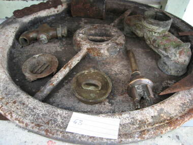
 Parks Victoria - Maldon State Battery
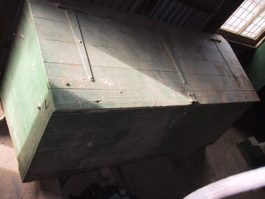
Box, tool
Used to store tools and other assorted items associated with Maldon State Battery..1 storage box with compartments and lid, painted green, made from wood, leather and are chains attatched from box to lid, trapeze shape, .3 grooves on top of box parallel to wooden supports on lid, latch, nails and bolts attatching wood and inner compartments, leather straps on innner lid and inside main compartment for holding tools, main compartment contains torn newspapers, severed cloths, pieces of rock, pipe peices made of metal and plastic, assortment of metal pieces, paint lids, green bucket with grease, food packaging, tap/valve, metal mesh, leather and plastic pieces, 2 keys/padlocks, nails, nuts, assortment of tools, wooden pieces, wooden handle for screwdriver, broken chair, chalk, pieces of ceramic (Bendigo pottery) , pocket handle with inscription, bottle lids, plastic container, rope/belt for machines, piece of belt, broken canvas strap, peices of broken dark brown glazed textured pottery, large circular threaded joins, large elboiw threaded elbow joins .2 upper left compartment containing brush head, sandpaper and assorted rusty metal objects .3 upper middle compartment containing rusty weighing hook, rusty bolt and scrap metal .4 upper right compartment containing broken tan pottery, rusty threaded T join, unknown green paper with inscription .5 lower left compartment containing white cotton waste, assorted circular rusty metal objects, assorted rusty nails and washers, orange lid with insciption, nut and bolt .6 lower left middle compartment containing unknown assorted metal objects, peice of broken clamp and felt .7 lower right middle compartment containing large rusty nuts and unknown rusty metal objects .8 lower right compartment containing assorted threaded rusty circular metal objects, rusty nut and bolt, metal pump part, rusty mobil oil tin 20litres, old newspaper scraps, -
 Bendigo Historical Society Inc.
Photograph - HILDA HILL COLLECTION: BLACK AND WHITE PHOTOS, 1921-1922
Series of Black & White Images of Hill Family in the years 1921-1922. Total 7 Photos. Darkie the horse tethered to stable. Zita, Nora, Rita & Doreen one Zita is dressed in black with white scarf around her neck and wearing a dark coloured hat, other three are all dressed in white Nora has a dark hat and other two have broad brimmed hats, Rita and Doreen have black ribbons hanging from their necks, to the right are a man and lady seated on the ground and in dark clothing, a man with a pipe in his mouth and wearing a grey suit and hat in background, lady in black and lady in white looking in other directions, background has grandstand with gab le roof and fronted by a white picket fence and people sitting at tables and chairs, trees in right background, Queenscliff February 1921. Rita Nora Doreen lying face down on the beach, girl on left has dark hat on, background shows large shed and other housing with fences, 'Merry Mermaids' Queenscliff 1921.Four girls and one male, three girls dressed in white, one in dark colour, two have light coloured hats and two have dark colour hats, one girl dressed in dark colour, male is wearing white trousers and college coat with stripes, background shows skyline of the nearby city and beach buildings, two men occupy a seat right back ground and dressed in dark clothing, Queenscliff 1921. Cyril Fred Mollie Doreen in a conga line the boys in grey suits and the girls in white, one has circular bands on her skirt, hedge in near back ground, gable roofed building and trees further back,'Durvol' January 1922. Hal wearing dark coat and jodhpurs long boots sitting astride a bicycle, something balanced between the handlebars and on the top bar, paling fence with vine hanging overhead other plants in the corner of the yard, December 24 1921. Doreen riding in a billy cart and pulled by a large dog along a pathway, Doreen is wearing all white, background is bushes and hedge with large tree, Dog is dark colour, 'I'm coming' January 1921.Hilda Hill Personal Collectionaustralia, history, post war life -
 Parks Victoria - Wilsons Promontory Lightstation
Tank lid
Lid for ship's tanks used for early domestic water storage (1860's) at the lightstation The water tank and lid are probably from the same unit that was used for transporting drinking water or perishable dry goods on ships. The unit comprised a large, riveted metal tank which was fitted with a heavy cast iron round lid to form a hermetically sealed container. It had a rubber sealing ring ‘which was screwed tight with the aid of lugs cast into the lid and wedges cast into the rim of the loading hole’. A raised iron rod welded across the outer face of many lids allowed for screwing the lid tight. Ship tanks were invented in1808 by notable engineer, Richard Trevithick and his associate John Dickinson. Their patent obtained the same year described the tank’s superior cubic shape that allowed it to fit squarely as a container in ships and thus use space efficiently, while its metal fabric preserved and secured its contents, whether liquid or solid, from damage. The containers revolutionised the movement of goods by ship and made wooden casks redundant. Research by Michael Pearson has determined that they were carried on passages to Australia from at least the 1830s, conveying ships’ victuals and water storage as well as general goods heading for the colonies, and by the 1870s they were in common use. Once in the colonies, the tanks were often recycled and adapted for many resourceful uses such as water tanks, packing cases, dog kennels, oil containers and food stores and this invariably led to the separation of the lid and tank. Raised lettering on the lids indicates that nearly all of the ship tanks transported to Australia came from London manufacturers, and it was usual also for the brand name to feature as a stencil on the associated square tank but in most cases this eventually wore off. It is not known if the Wilsons Promontory tank retains its stencil, and the heavy lid will need to be turned over to reveal its manufacturer’s name. How it came to the lightstation is also not known, but it was either brought to the site as a recycled tank or salvaged from a shipwreck. Pearson writes that Ship tanks show up at a wide range of sites, many of them isolated like lighthouses. They were, I think, usually taken there for the purposes they filled, usually water storage, as they were readily available, relatively light to transport, and probably very cheap to buy as second‐hand goods containers. In rural areas they may have been scavenged for their new uses from local stores, to whom goods were delivered in them. Recycled to serve as a water tank, the Wilsons Promontory tank is the last surviving example of several that were used at the site to hold water for domestic consumption. The tank has had its lid removed and a tap fitted to the one of the sides. It stands on concrete blocks next to a building to receive water running off the roof via a metal pipe. Wilsons Promontory is the only lightstation managed by Parks Victoria with a tank container, although Cape Otway and Point Hicks have lids. Parks Victoria has identified four other lids which include two at Point Hicks, one manufactured by Lancaster and Co. the other by Bellamy. Cape Otway also has two, one unidentified and the other by the Bow Tank Works, East London, which produced tanks between 1910 and 1930. Pearson notes that ‘surviving lids are far less numerous than the tanks themselves, presumably because the uses to which the tanks were put did not require the lid to be retained’. The tank and lid, which are possibly part of the same unit, have first level contributory significance for their historic values and rarity. Round ship's tanks lid, iron. -
 Federation University Historical Collection
Book - Book - Ledger, Ballarat School of Mines Donation Book, 1978-1896, 01/01/1878 - 01/08/1896
Leather bound ledger with hand written details on donations to the Ballarat School of Mines Museum or the Ballarat School of Mines Library. The Ledger was made by J. McHutchison, Bookbinder, paper ruler and Account Book Manufacturer. 267. 07 July 1880 - John Lynch Junior - Smythesdale - Cast of "Golden Age" nugget found at Browns by Co-operative Party - 12 men. Weight 75 oz 12 dwts 12 grs 294. 24 June 1880 - W.H. Shaw - Ballarat - 94 numbers of 'The Engineer'. 295. 28 June 1880 - Rivett Henry Bland - Clunes - Specimen of water pipe from the Port Phillip Consols Mine encrusted with Carbonates of lime and magnesia and sulphate of lime with earthy matter. 418. 17 June 1881 - F. Ratte - Sydney - Catalogue of Rocks, minerals, etc of New Caledonia. 462. 28 September 1881 - Dr Bunce - Ballarat - Concretionary Basalt with Car. Lime and Magnesia. 465. 06 September 1881 - J.J. Sleep (Chairman of the Board) per favor of E.W. Spain, Esq, Manr - Ballarat - Diamond drill core from "Carisbrook Freehold Estate" - cut at a depth of 150 feet. Dedrites from Munster Gully ... 517. 20 January 1882 - William Lester - Ballarat - The Agricultural Teacher 549. 24 March 1882 - C.E. Grainger Manager Ballarat Woollen Mills - Ballarat - Samples of dyed and raw wool and dye material. 600. 04 July 1882 - Henry Sutton - Ballarat - 13th Annual Report of the Aeronautical Society of Great Britain. 1222. 31 October 1884 - Trooper Dowling - Miner's Rest - Owl 1223. 04 November 1884 - W. McKeenan - 3, Adair St, Ballarat - Flying Squirrel. 1259. 16 January 1885 - A.A. Buley - Ballarat - Prospective of Grenville College 1885 1428. 06 October 1885 - Ballarat - Collection of mineral specimens from Silverton (Collected by Mr James Murray). 1442. 20 October 1885 - Ballarat - Specimen of fossil fruits collected by Haddon by Charles Brown. 1682. 28 February 1887 - James Lamb - Ballarat - Copy of the Ballarat Times Newspaper of 3rd December 1854, framed and protected on both sides with glass. 1730. 23 May 1887 - Bella Guerin - Ballarat - Copy of the Victorian Review No 74 December 1885 4786. 27 March 1894 - James Oddie - Ballarat - 3 mineral specimens 4835. 01 August 1896 - P.V> Barnard - Ballarat - {ortion of Mining truck wheel altered to oxide of iron found in the old workings of the Golden Gate Mine at a depth of 200 feet. (4235 is last entry)ballarat school of mines, ballarat school of mines museum, donations, henry sutton, bella guerin -
 Eltham District Historical Society Inc
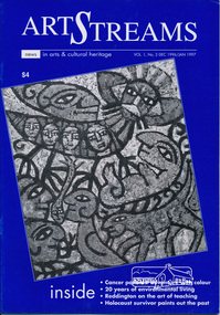
Journal, Peter Doughtery, ArtStreams: News in arts and cultural heritage; Vol. 1, No. 2, Dec 1996/Jan 1997, 1996
Vol. 1, No. 2 Dec 1996/Jan 1997 CONTENTS ADVENTURE WITH COLOUR Teenage cancer patients challenge their illness with art 3 CD REVIEWS New music by local musicians 5 LIVE AND LET LIVE 20 years of environmental living 6 AUSTRALIA REVISITED Artist Charles Reddington ponders live 30 years on 8 POETRY REVIEW Anne Delaney looks at new work by Jennifer Harrison and Jordie Albiston 11 PHOTOGRAPHY Katherine Jones aims at hard edges 16 IMAGES FROM A DARK PAST Holocaust survivor paints out a traumatic part of his life 18 MORALITY OF JUSTICE The Truth Game - a play by Ray Mooney 21 ART FROM THE HEART An exhibition that crosses boundaries 22 SHORT STORY New story from an emerging writer 25 ART IN THE CEMETERY Darebin launches a new project to decorate its new mausoleum 28 LISTINGS Artists, performers and galleries 29 KEYWORDS 895 Main Road, 1994 Moet et Chandon Fellowship, Adventure with Colour, Alan Bonney, Alan Constable, Alun Leach-Jones, Amada Laming, Anne Connor & Associates, Anne Delaney, Anthony Day, Art Streams Magazine, Artist-in-residence, Arts by the Waters, Arts project Australia, Auschwitz, Banyule Jazz Festival, Barbara Veheary, Bend of Islands Conservation Association (BICA), Bend of Islands Estate, Bend of Islands, Bill Downing, Bulleen Art & Garden Centre, Bulleen Nursery, Caffe Poco, Carlton Courthouse Theatre, Catani Boulevard, Catherine Oxley Reserve, Charles Reddington, Charlie Dowley, Cheryl Daye, Chris McAuliffe, Clifton Pugh, Colin Lanceley, Cornelia Selover, Creativitie et Handicap Mental (CREAHM), Cynthia Hardman, Cyril Tawney, Damian Eyre, Daniel Lillford, Danuta Michalska, Darebin Arts and Entertainment Centre, Darebin City Council, Department of Fine Arts, Donald Campbell, Dora Zable, Dorothy Berry, dunmoochin, E.H. Cameron, Edward (Ned) Haughton, Edward Car, Elizabeth Vercoe, Eltham High School, Eltham Living and Learning Centre, Environmental Living Zone (ELZ), Eric Bogle, Eucalypso, Felix Tuszynski, Food For All Seasons, Frank Hodgkinson, Fulli Andrinopoulos, Gallery of Georges of Collins Street, Gallery of Slavic Art, Glen Agnes Bend of Islands Estate, Glen Agnes Estate, Gongflers drive, Greg O'Leary, Harold (Jimmy) Fuller, Helen O'Grady Children's Drama Academy, Henley Road, Ian Doolan Hamilton, Ian Gawler, Inside Out/Outside In, Ironbark Road, Janice McBride, Jennifer Harrison, Jennifer McGregor, Jessie Agnes Haughton, Jimmy Pike, Joan Blakey, John Mackay Northe, John Rasmussen, Jordie Albiston, Julian Martin, Kangaroo Ground, Katherine Jones, Kelvin Heffernan, Kew Coattage, Kitty Ginter, Lavita Mossop, Les darcy, Les Gyori, Life with Jane, Lorraine Larter, Luc Boulange, Luciana Giardina, Manningham Artspace, Manningham City Council, Mariann Moxon, Mark Capozzi, Mark Chapman, Mark Wilkinson, Maxine Ryder, Melbourne Police Pipe Band, Mick Woiwod, Mike O'Rourke, Monica Burns, Montsalvat, Myra Hilgendorf, Nancye Ball, Page family, Pam Crohan, Pam Dougherty, Poetry, Preston Public Cemetery, Ray Mooney, Richard Haese, Robert Hughes, Robyn Kirkpatrick, Roger Lemke, Ron Hanson, Sandra Harvey, Shire of Eltham Office site, Shire of Healesville, Shire of Nillumbik, Shire Offices, Sounds by the Waters, Stelio Costa, Steven Tynan, Steven Worrell, Stewart Whiffin, Sue Howard, Sue Whiffin, Sugarloaf Reservoir, Sydney Ball, The Art of Australia, The Mews, The Truth Game, Tom Fantl, Tony Inglese, Tuszynski Survey Exhibition, University of Melbourne, Valerio Ciccone, victorian artists supplies, Watson Creek Bridge, Watsons Creek, Wayne Marnell, Woody Guthrie, Yarra Brae Dam, Yarra River"Peter Dougherty has been involved in the local art scene for many years. As publisher and editor of the arts magazine Artstreams, his comments on the various branches of the arts are widely respected. His "The Arts" column in the Diamond Valley Leader presents a brief summary for a much wider cross section of the local community. Peter also operates his own gallery and the Artstreams Cafe at the St Andrews market. Peter has a wealth of knowledge about present day and historical aspects of local art and artists." - Eltham District Historical Society Newsletter No. 161, March 2005Colour front and back cover with feature articles and literary pieces with photographs and advertisements printed in black and white. 36 pages, 30 cm. Vol. 1, no. 1 (Nov. 1996) - Vol. 10, no. 5 (summer ed. 2005/06) art streams, feliz tuszynski, elizabeth vercoe, eucalypso, bend of islands, charles reddington, jennifer harrison, jordie albiston, katherine jones, anne bonney, mick woiwood, anne connor, anne delaney, ray mooney, pam dougherty, arts project australia, lavita mossop, preston public cemetery, helen o'grady children's drama academy, bulleen nursery -
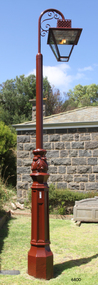 Flagstaff Hill Maritime Museum and Village
Functional object - Lamp Light, late 19th - early-20th century
This gas lamp light and stand came from the original manufacturer in Melbourne. Gas street lights such as this one were used in Melbourne from the mid-19th century. The lights enabled safer after-dark travel for pedestrians and vehicles and were a deterrent to crime. A lamp lighter was employed to keep the lamps lit, sometimes with little success due to weather conditions and the pranks of youths. WARRNAMBOOL Gasworks In Warrnambool prior to 1874 there were about twenty rare, individually lit street lights in Warrnambool, each with its own supply of kerosene. These lamps were in the central business area of Timor, Koroit and Liebig Streets. The Warrnambool Gas Company Ltd. was registered as an incorporated company in 1873. It was a private, locally owned business. It was located at 209-215 Merri Street, Warrnambool, on the land, which is just west of the later-built railway station. The first managers of the Gas Company lived in a substantial stone house on site, but later the managers lived in a residence in Henna Street between Merri and Timor Streets. The original home, which still stands, became a residence for the Railway Station Master from about 1890. In August 1874 the construction of the gasworks was complete and at the end of that month gas was supplied to all of the existing lamps in Warrnambool for the first time. The Warrnambool Gas Company wound up in 1880-1881 and was purchased by the Warrnambool Borough Council with money raised by a loan – the Borough’s first ‘loan transaction’. The Council established a piped network to supply gas to other street connections. The gasworks were privatised and upgraded in 1952. In 1972 the town supply was converted to liquid petroleum gas and by the early 1980s the gasworks were closed down. In 1986 Warrnambool was supplied with natural gas from a site near Port Campbell. The Warrnambool gasworks supplied all street and shop lighting and most domestic lighting until 1923 when electricity was available for lighting. Bromfield Street in Warrnambool was named after the director of the gasworks, James Astley Bromfield (1823-1903). He arrived in Warrnambool from Worcestershire, England, in 1852 and was very active in the local council and community. Cockman Street was named after the first secretary of the gasworks in 1874, Walter Cockman (c.1821-1892). He was a Mayor and businessman. The second Manager, Luther Rodgers, worked for the gas company for about twenty years and both Rodger Place and Rodgers Road in Warrnambool have been named after him. LAMP LIGHTS IN MELBOURNE In the 1820s Melbourne's innkeepers were legally required to have a lamp light outside their premises from sunset to sunrise. This was the first instance of street lamps being used in Melbourne. In 1847 the first oil lamp was used in the city. In 1849 a gas lamp was installed on the Swanston Street Bridge and much of the city had oil lamps installed by then. In August 1857 the installation of street gas lamps began in Melbourne. They were welcomed for the much brighter illumination they gave. By 1860 there were 414 lamp pillars. The phrase was quoted often - "A light was as good as a policeman". The first gas burners used for street lighting were called 'fishtail' gas burners. These were replaced in the early 1900s by gas mantles. The City of Melbourne Gas Coke Company was formed in 1850 but due to the Gold Rush the manufacture and distribution of the gas supply was delayed until January 1856. By the 1890s the gas supplying the lights was supplied by three companies in Melbourne. In 1879 a football match was played at the MCG under electric lighting and gradually electric arc lights were installed inside and outside buildings in the city. Lamp lights such as the one in Flagstaff Hill’s collection were no longer needed. (References: John Lindsay re Lamp Light history 2019-01-29, Former Warrnambool Gas Company Limited, Victorian Heritage Database Report, Heritage Number 149746 https://vhd.heritagecouncil.vic.gov.au/places/149746/download-report ) The lamp light is representative of the lamps used in Melbourne from the mid-nineteenth century to light the streets at night and make Melbourne a safer city. The lamp is also representative of the gas street lighting in Warrnambool from the mid-1870s-1920s.Lamp light or gas light. Street light, one of the last gas street lights removed from Melbourne. (Reconditioned by Friends of Flagstaff Hill, 2013)flagstaff hill, warrnambool, shipwrecked coast, flagstaff hill maritime museum, maritime museum, shipwreck coast, flagstaff hill maritime village, great ocean road, lamp light, gas light, gas lamp, street lamp, street light, gas street light, melbourne street lighting, warrnambool street lighting, melbourne gas street light, warrnambool gas company, warrnambool gasworks, james bromfield, walter cockman, luther rodgers, city of melbourne gas coke company -
 Uniting Church Archives - Synod of Victoria
Photograph, Parkville Presbyterian Church, Undated
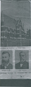
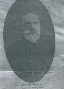
The College Church congregation initially worshipped in Ormond College in 1891. In 1895 they purchased the site of the present building. A committee set out certain specifications (including the crown tower), and a competition for the best design was won by architect RA Lawson. The building, constructed by Lang Brothers of Parkville at a cost of 2,170 pounds, was opened in 1898. College Church remained the only parish church in Parkville until 1934. The outstanding element is the crown tower, a choice of the first minister, the Reverend Alexander Yule. It is a copy, albeit on a reduced scale, of King's College Chapel, Aberdeen University, of which Reverend Yule was a former student. This crown tower is the only example in Victoria and is possibly unique in Australia. The church is constructed of red brick and Oamaru sandstone with a steeply pitched slate roof and parapeted gables. Windows are in the Gothic pointed arch style. The interior of the Church has a fine timber ceiling with arch braces. There are a number of quality stained glass windows, the two largest being dedicated to Mungo Scott and his wife, Scott having been a benefactor of the Church. The late nineteenth century pipe organ was built by George Fincham and Son (Richmond), with Professor Franklin Peterson as consultant, and was completed in November 1903. In the 1940s College Church was internally re-ordered and this work was designed by prominent church architect, Louis Williams. The church became part of the Uniting Church in Australia in 1977, and ownership subsequently passed to Mar Thoma Syrian Church in 2008. From The Argus, Friday 19 April 1907: Rev. Alexander Yule washeld in highest esteem in his ministerialbrethren and a large circle of friends was abundanrly evident by the expressions ofsorrowful regret at his death and of sympathy with his widow and her three sonsby those who attended the funeral servicesyesterday morning. To most of those present the announcement of Mr. Yule's death, made in "The Argus" on Wednesday, came as a painful surprise. It was known that at the time of his ministerial jubilee last January he shown symptoms of failing health, and that his illness had gradually become more serious, but few among the intimate friends of the family thought the end was so near. Although Mr. Yule suffered much physical weakness, his mental faculties were unimpaired, and he was able to carry on his ministerial work almost to the last. He even conducted the services at the College Church, Parkville, on Sunday, March 31. Testimony is borne that his ministry was appreciated most highly by the important congregations, both in Scotland and Victoria, under his charge; that in the church courts he was a safe and wise counsellor; and that he did excellent service on various committees, and as the convenor of the Theological-hall committee, on which he was appointed by the General Assembly. The esteem in which he was regarded by the Presbyterian Church as a whole was expressed in his election in 1891 to the Moderator's chair of the Victorian Church, and to that of the Federal Assembly in 1901. The funeral service was held at College Church, the scene of Mr. Yule's ministry since 1891. The building was filled to overflowing by a congregation that included most of the members of the metropolitan presbyteries, representatives from several of the provincial presbyterues, the students of the Theological-hall, members of the Parkville congregation, and the children of Miss Sutherland's Home. The pulpit and furniture were draped in black, and the plain oak coffin rested on the communion-table. The simple yet impressive service usual with the Presbyterian Church was conducted by Professor Rentoul, president of the Theological-hall Senatus, who was assisted by Professor Skene, Rev. W. Fraser (moderator of the Melbourne North Presbytery), Rev. D. S. McEacharn, and the Rev. John Thomson, a life-long friend of the departed minister. The Dead March in "Saul" was played on the organ as the coffin was borne to the hearse. The procession along Parkville-crescent to the cemetery gates was a notable one, and in the following order:—Theological-hall students; the hearse; the chief mourners—Dr. Yule, Rev. A. Yule, Mr. James Yule, and Mr. Groom, M.H.R., a relative of the family; the Theological-hall professors and committee; members of the presbyteries; and other friends, making a large and repre-sentative gathering. At the grave Professor Rentoul, Rev. Dr. Meiklejohn, Rev. D. Ross, and the Rev. Dr. Marshall officiated. The pall-bearers were Revs. D. S. McEachran, J. Thomson, A. McDonald, R. J. Smith,Mr. P. McLennan and Mr. L. E. Groom, M.H.R. The funeral arrangement were in the hands of Mr. Josiah Holdsworth.Portion of photocopy of the church and two of the portraits.college church, presbyterian church, yule, rev. alexander -
 Uniting Church Archives - Synod of Victoria
Photograph, Parkville Presbyterian Church, Undated
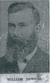
The College Church congregation initially worshipped in Ormond College in 1891. In 1895 they purchased the site of the present building. A committee set out certain specifications (including the crown tower), and a competition for the best design was won by architect RA Lawson. The building, constructed by Lang Brothers of Parkville at a cost of 2,170 pounds, was opened in 1898. College Church remained the only parish church in Parkville until 1934. The outstanding element is the crown tower, a choice of the first minister, the Reverend Alexander Yule. It is a copy, albeit on a reduced scale, of King's College Chapel, Aberdeen University, of which Reverend Yule was a former student. This crown tower is the only example in Victoria and is possibly unique in Australia. The church is constructed of red brick and Oamaru sandstone with a steeply pitched slate roof and parapeted gables. Windows are in the Gothic pointed arch style. The interior of the Church has a fine timber ceiling with arch braces. There are a number of quality stained glass windows, the two largest being dedicated to Mungo Scott and his wife, Scott having been a benefactor of the Church. The late nineteenth century pipe organ was built by George Fincham and Son (Richmond), with Professor Franklin Peterson as consultant, and was completed in November 1903. In the 1940s College Church was internally re-ordered and this work was designed by prominent church architect, Louis Williams. The church became part of the Uniting Church in Australia in 1977, and ownership subsequently passed to Mar Thoma Syrian Church in 2008. From The Argus, Friday 19 April 1907: Rev. Alexander Yule washeld in highest esteem in his ministerialbrethren and a large circle of friends was abundanrly evident by the expressions ofsorrowful regret at his death and of sympathy with his widow and her three sonsby those who attended the funeral servicesyesterday morning. To most of those present the announcement of Mr. Yule's death, made in "The Argus" on Wednesday, came as a painful surprise. It was known that at the time of his ministerial jubilee last January he shown symptoms of failing health, and that his illness had gradually become more serious, but few among the intimate friends of the family thought the end was so near. Although Mr. Yule suffered much physical weakness, his mental faculties were unimpaired, and he was able to carry on his ministerial work almost to the last. He even conducted the services at the College Church, Parkville, on Sunday, March 31. Testimony is borne that his ministry was appreciated most highly by the important congregations, both in Scotland and Victoria, under his charge; that in the church courts he was a safe and wise counsellor; and that he did excellent service on various committees, and as the convenor of the Theological-hall committee, on which he was appointed by the General Assembly. The esteem in which he was regarded by the Presbyterian Church as a whole was expressed in his election in 1891 to the Moderator's chair of the Victorian Church, and to that of the Federal Assembly in 1901. The funeral service was held at College Church, the scene of Mr. Yule's ministry since 1891. The building was filled to overflowing by a congregation that included most of the members of the metropolitan presbyteries, representatives from several of the provincial presbyterues, the students of the Theological-hall, members of the Parkville congregation, and the children of Miss Sutherland's Home. The pulpit and furniture were draped in black, and the plain oak coffin rested on the communion-table. The simple yet impressive service usual with the Presbyterian Church was conducted by Professor Rentoul, president of the Theological-hall Senatus, who was assisted by Professor Skene, Rev. W. Fraser (moderator of the Melbourne North Presbytery), Rev. D. S. McEacharn, and the Rev. John Thomson, a life-long friend of the departed minister. The Dead March in "Saul" was played on the organ as the coffin was borne to the hearse. The procession along Parkville-crescent to the cemetery gates was a notable one, and in the following order:—Theological-hall students; the hearse; the chief mourners—Dr. Yule, Rev. A. Yule, Mr. James Yule, and Mr. Groom, M.H.R., a relative of the family; the Theological-hall professors and committee; members of the presbyteries; and other friends, making a large and repre-sentative gathering. At the grave Professor Rentoul, Rev. Dr. Meiklejohn, Rev. D. Ross, and the Rev. Dr. Marshall officiated. The pall-bearers were Revs. D. S. McEachran, J. Thomson, A. McDonald, R. J. Smith,Mr. P. McLennan and Mr. L. E. Groom, M.H.R. The funeral arrangement were in the hands of Mr. Josiah Holdsworth.William Downes - one of the founders.college church, presbyterian church, yule, rev. alexander -
 Uniting Church Archives - Synod of Victoria
Photograph, Parkville Presbyterian Church, Undated
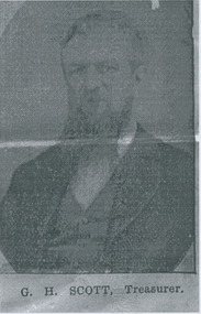
The College Church congregation initially worshipped in Ormond College in 1891. In 1895 they purchased the site of the present building. A committee set out certain specifications (including the crown tower), and a competition for the best design was won by architect RA Lawson. The building, constructed by Lang Brothers of Parkville at a cost of 2,170 pounds, was opened in 1898. College Church remained the only parish church in Parkville until 1934. The outstanding element is the crown tower, a choice of the first minister, the Reverend Alexander Yule. It is a copy, albeit on a reduced scale, of King's College Chapel, Aberdeen University, of which Reverend Yule was a former student. This crown tower is the only example in Victoria and is possibly unique in Australia. The church is constructed of red brick and Oamaru sandstone with a steeply pitched slate roof and parapeted gables. Windows are in the Gothic pointed arch style. The interior of the Church has a fine timber ceiling with arch braces. There are a number of quality stained glass windows, the two largest being dedicated to Mungo Scott and his wife, Scott having been a benefactor of the Church. The late nineteenth century pipe organ was built by George Fincham and Son (Richmond), with Professor Franklin Peterson as consultant, and was completed in November 1903. In the 1940s College Church was internally re-ordered and this work was designed by prominent church architect, Louis Williams. The church became part of the Uniting Church in Australia in 1977, and ownership subsequently passed to Mar Thoma Syrian Church in 2008. From The Argus, Friday 19 April 1907: Rev. Alexander Yule washeld in highest esteem in his ministerialbrethren and a large circle of friends was abundanrly evident by the expressions ofsorrowful regret at his death and of sympathy with his widow and her three sonsby those who attended the funeral servicesyesterday morning. To most of those present the announcement of Mr. Yule's death, made in "The Argus" on Wednesday, came as a painful surprise. It was known that at the time of his ministerial jubilee last January he shown symptoms of failing health, and that his illness had gradually become more serious, but few among the intimate friends of the family thought the end was so near. Although Mr. Yule suffered much physical weakness, his mental faculties were unimpaired, and he was able to carry on his ministerial work almost to the last. He even conducted the services at the College Church, Parkville, on Sunday, March 31. Testimony is borne that his ministry was appreciated most highly by the important congregations, both in Scotland and Victoria, under his charge; that in the church courts he was a safe and wise counsellor; and that he did excellent service on various committees, and as the convenor of the Theological-hall committee, on which he was appointed by the General Assembly. The esteem in which he was regarded by the Presbyterian Church as a whole was expressed in his election in 1891 to the Moderator's chair of the Victorian Church, and to that of the Federal Assembly in 1901. The funeral service was held at College Church, the scene of Mr. Yule's ministry since 1891. The building was filled to overflowing by a congregation that included most of the members of the metropolitan presbyteries, representatives from several of the provincial presbyterues, the students of the Theological-hall, members of the Parkville congregation, and the children of Miss Sutherland's Home. The pulpit and furniture were draped in black, and the plain oak coffin rested on the communion-table. The simple yet impressive service usual with the Presbyterian Church was conducted by Professor Rentoul, president of the Theological-hall Senatus, who was assisted by Professor Skene, Rev. W. Fraser (moderator of the Melbourne North Presbytery), Rev. D. S. McEacharn, and the Rev. John Thomson, a life-long friend of the departed minister. The Dead March in "Saul" was played on the organ as the coffin was borne to the hearse. The procession along Parkville-crescent to the cemetery gates was a notable one, and in the following order:—Theological-hall students; the hearse; the chief mourners—Dr. Yule, Rev. A. Yule, Mr. James Yule, and Mr. Groom, M.H.R., a relative of the family; the Theological-hall professors and committee; members of the presbyteries; and other friends, making a large and repre-sentative gathering. At the grave Professor Rentoul, Rev. Dr. Meiklejohn, Rev. D. Ross, and the Rev. Dr. Marshall officiated. The pall-bearers were Revs. D. S. McEachran, J. Thomson, A. McDonald, R. J. Smith,Mr. P. McLennan and Mr. L. E. Groom, M.H.R. The funeral arrangement were in the hands of Mr. Josiah Holdsworth.G. H. Scott - Treasurer.college church, presbyterian church, yule, rev. alexander -
 Uniting Church Archives - Synod of Victoria
Photograph, Parkville Presbyterian Church, Undated
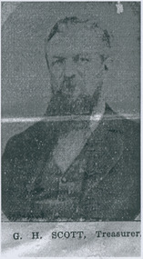
The College Church congregation initially worshipped in Ormond College in 1891. In 1895 they purchased the site of the present building. A committee set out certain specifications (including the crown tower), and a competition for the best design was won by architect RA Lawson. The building, constructed by Lang Brothers of Parkville at a cost of 2,170 pounds, was opened in 1898. College Church remained the only parish church in Parkville until 1934. The outstanding element is the crown tower, a choice of the first minister, the Reverend Alexander Yule. It is a copy, albeit on a reduced scale, of King's College Chapel, Aberdeen University, of which Reverend Yule was a former student. This crown tower is the only example in Victoria and is possibly unique in Australia. The church is constructed of red brick and Oamaru sandstone with a steeply pitched slate roof and parapeted gables. Windows are in the Gothic pointed arch style. The interior of the Church has a fine timber ceiling with arch braces. There are a number of quality stained glass windows, the two largest being dedicated to Mungo Scott and his wife, Scott having been a benefactor of the Church. The late nineteenth century pipe organ was built by George Fincham and Son (Richmond), with Professor Franklin Peterson as consultant, and was completed in November 1903. In the 1940s College Church was internally re-ordered and this work was designed by prominent church architect, Louis Williams. The church became part of the Uniting Church in Australia in 1977, and ownership subsequently passed to Mar Thoma Syrian Church in 2008. From The Argus, Friday 19 April 1907: Rev. Alexander Yule washeld in highest esteem in his ministerialbrethren and a large circle of friends was abundanrly evident by the expressions ofsorrowful regret at his death and of sympathy with his widow and her three sonsby those who attended the funeral servicesyesterday morning. To most of those present the announcement of Mr. Yule's death, made in "The Argus" on Wednesday, came as a painful surprise. It was known that at the time of his ministerial jubilee last January he shown symptoms of failing health, and that his illness had gradually become more serious, but few among the intimate friends of the family thought the end was so near. Although Mr. Yule suffered much physical weakness, his mental faculties were unimpaired, and he was able to carry on his ministerial work almost to the last. He even conducted the services at the College Church, Parkville, on Sunday, March 31. Testimony is borne that his ministry was appreciated most highly by the important congregations, both in Scotland and Victoria, under his charge; that in the church courts he was a safe and wise counsellor; and that he did excellent service on various committees, and as the convenor of the Theological-hall committee, on which he was appointed by the General Assembly. The esteem in which he was regarded by the Presbyterian Church as a whole was expressed in his election in 1891 to the Moderator's chair of the Victorian Church, and to that of the Federal Assembly in 1901. The funeral service was held at College Church, the scene of Mr. Yule's ministry since 1891. The building was filled to overflowing by a congregation that included most of the members of the metropolitan presbyteries, representatives from several of the provincial presbyterues, the students of the Theological-hall, members of the Parkville congregation, and the children of Miss Sutherland's Home. The pulpit and furniture were draped in black, and the plain oak coffin rested on the communion-table. The simple yet impressive service usual with the Presbyterian Church was conducted by Professor Rentoul, president of the Theological-hall Senatus, who was assisted by Professor Skene, Rev. W. Fraser (moderator of the Melbourne North Presbytery), Rev. D. S. McEacharn, and the Rev. John Thomson, a life-long friend of the departed minister. The Dead March in "Saul" was played on the organ as the coffin was borne to the hearse. The procession along Parkville-crescent to the cemetery gates was a notable one, and in the following order:—Theological-hall students; the hearse; the chief mourners—Dr. Yule, Rev. A. Yule, Mr. James Yule, and Mr. Groom, M.H.R., a relative of the family; the Theological-hall professors and committee; members of the presbyteries; and other friends, making a large and repre-sentative gathering. At the grave Professor Rentoul, Rev. Dr. Meiklejohn, Rev. D. Ross, and the Rev. Dr. Marshall officiated. The pall-bearers were Revs. D. S. McEachran, J. Thomson, A. McDonald, R. J. Smith,Mr. P. McLennan and Mr. L. E. Groom, M.H.R. The funeral arrangement were in the hands of Mr. Josiah Holdsworth.G. H. Scott - Treasurer.college church, presbyterian church, yule, rev. alexander -
 Uniting Church Archives - Synod of Victoria
Photograph, Parkville Presbyterian Church, Undated
The College Church congregation initially worshipped in Ormond College in 1891. In 1895 they purchased the site of the present building. A committee set out certain specifications (including the crown tower), and a competition for the best design was won by architect RA Lawson. The building, constructed by Lang Brothers of Parkville at a cost of 2,170 pounds, was opened in 1898. College Church remained the only parish church in Parkville until 1934. The outstanding element is the crown tower, a choice of the first minister, the Reverend Alexander Yule. It is a copy, albeit on a reduced scale, of King's College Chapel, Aberdeen University, of which Reverend Yule was a former student. This crown tower is the only example in Victoria and is possibly unique in Australia. The church is constructed of red brick and Oamaru sandstone with a steeply pitched slate roof and parapeted gables. Windows are in the Gothic pointed arch style. The interior of the Church has a fine timber ceiling with arch braces. There are a number of quality stained glass windows, the two largest being dedicated to Mungo Scott and his wife, Scott having been a benefactor of the Church. The late nineteenth century pipe organ was built by George Fincham and Son (Richmond), with Professor Franklin Peterson as consultant, and was completed in November 1903. In the 1940s College Church was internally re-ordered and this work was designed by prominent church architect, Louis Williams. The church became part of the Uniting Church in Australia in 1977, and ownership subsequently passed to Mar Thoma Syrian Church in 2008. From The Argus, Friday 19 April 1907: Rev. Alexander Yule washeld in highest esteem in his ministerialbrethren and a large circle of friends was abundanrly evident by the expressions ofsorrowful regret at his death and of sympathy with his widow and her three sonsby those who attended the funeral servicesyesterday morning. To most of those present the announcement of Mr. Yule's death, made in "The Argus" on Wednesday, came as a painful surprise. It was known that at the time of his ministerial jubilee last January he shown symptoms of failing health, and that his illness had gradually become more serious, but few among the intimate friends of the family thought the end was so near. Although Mr. Yule suffered much physical weakness, his mental faculties were unimpaired, and he was able to carry on his ministerial work almost to the last. He even conducted the services at the College Church, Parkville, on Sunday, March 31. Testimony is borne that his ministry was appreciated most highly by the important congregations, both in Scotland and Victoria, under his charge; that in the church courts he was a safe and wise counsellor; and that he did excellent service on various committees, and as the convenor of the Theological-hall committee, on which he was appointed by the General Assembly. The esteem in which he was regarded by the Presbyterian Church as a whole was expressed in his election in 1891 to the Moderator's chair of the Victorian Church, and to that of the Federal Assembly in 1901. The funeral service was held at College Church, the scene of Mr. Yule's ministry since 1891. The building was filled to overflowing by a congregation that included most of the members of the metropolitan presbyteries, representatives from several of the provincial presbyterues, the students of the Theological-hall, members of the Parkville congregation, and the children of Miss Sutherland's Home. The pulpit and furniture were draped in black, and the plain oak coffin rested on the communion-table. The simple yet impressive service usual with the Presbyterian Church was conducted by Professor Rentoul, president of the Theological-hall Senatus, who was assisted by Professor Skene, Rev. W. Fraser (moderator of the Melbourne North Presbytery), Rev. D. S. McEacharn, and the Rev. John Thomson, a life-long friend of the departed minister. The Dead March in "Saul" was played on the organ as the coffin was borne to the hearse. The procession along Parkville-crescent to the cemetery gates was a notable one, and in the following order:—Theological-hall students; the hearse; the chief mourners—Dr. Yule, Rev. A. Yule, Mr. James Yule, and Mr. Groom, M.H.R., a relative of the family; the Theological-hall professors and committee; members of the presbyteries; and other friends, making a large and repre-sentative gathering. At the grave Professor Rentoul, Rev. Dr. Meiklejohn, Rev. D. Ross, and the Rev. Dr. Marshall officiated. The pall-bearers were Revs. D. S. McEachran, J. Thomson, A. McDonald, R. J. Smith,Mr. P. McLennan and Mr. L. E. Groom, M.H.R. The funeral arrangement were in the hands of Mr. Josiah Holdsworth.Rev. Alexander Yule M.A.Born 1830 - 1907.college church, presbyterian church, yule, rev. alexander -
 Eltham District Historical Society Inc
Photograph - Digital Photograph, Alan King, Monash Bridge, Hurstbridge, 23 January 2008
Monash Bridge spans the Diamond Creek at Hurstbridge. It was built in 1917 for the Shires of Heidelberg, Eltham and Whittlesea. It is considered Nillumbik Shire's finest engineered bridge and was construced by the engineering company of Sir John Monash. Covered under Heritage Overlay, Nillumbik Planning Scheme. Published: Nillumbik Now and Then / Marguerite Marshall 2008; photographs Alan King with Marguerite Marshall.; p117 Monash Bridge is considered the Shire’s finest engineered bridge and was constructed by the engineering company of that great Australian, Sir John Monash.1 The bridge spans Diamond Creek on the Hurstbridge-Arthurs Creek Road, linking Hurstbridge with Yarrambat and Arthurs Creek. Monash Bridge, also called Hurst’s Bridge, was built in 1917, by the Reinforced Concrete and Monier Pipe Construction Company Pty Ltd, for the Shires of Heidelberg, Eltham and Whittlesea. Although Monash was probably in action overseas during World War One when the bridge was designed and constructed, he evolved the basic design in the 1900s and it was a standard design for the firm. However J A Laing, a designer at the firm, was probably the designer, as his initials are on bridge drawings held by the Eltham District Historical Society.2 The bridge is an excellent early Australian example of an open spandrel reinforced concrete arch bridge and has a single span of 29 metres. It is unusual in Victoria, but similar to many reinforced concrete arch bridges in Europe and America, built from the late 19th century. In Victoria, Monash pioneered the use of reinforced concrete – then a revolutionary construction material. His company, Monash & Anderson, had the exclusive licence for the Monier patent for the system of reinforced concrete construction for Victoria and New South Wales. A well-known example of the Monier arch bridge is the Morell Bridge in South Yarra. The sweeping arch of the Monash Bridge combines grace and utility and blends with the surrounding rural landscape. Its design and construction have allowed it to carry increasing volumes of heavy traffic, but in modern times the one lane is considered by some to prevent easy passage through Hurstbridge. However others consider this an asset to deter too much more traffic, which would diminish Hurstbridge’s charming rural character.3 This is the third bridge across the Diamond Creek at this site. The original bridge was a log bridge upstream, constructed in the 1850s by early settler, Henry Hurst, after whom Hurstbridge was named. The bridge spanned the creek, where it divided his family’s property. In the 1880s a timber bridge replaced it, known as Hurst’s Bridge. However a more permanent bridge was considered necessary when the new railway arrived in 1912, bringing with it expectations of growth in the town and the surrounding fruit-growing district. Monash Bridge’s official opening on November 3, 1917 was a gala occasion, which took place before about 1000 spectators. Two who attended the opening had a particularly sound knowledge of the locality. One was Fred Hurst, Henry’s brother, who used to ford the creek at or near the bridge’s site more than 50 years before. The other was John McDonald of Arthurs Creek, who had built the old wooden bridge over the creek about 40 years earlier.4 Although John Monash was a fine engineer, his fame came from his brilliant war career, rather than from his engineering or his many other achievements. Monash was Corps Commander of the Australian Forces. His brilliance was recognised with his awards: Knight Grand Cross of the Order of St. Michael and St. George, and Knight Commander of the Bath. Monash was also decorated by the French, Belgian, and American Governments.5 After the war, Monash worked in many prominent civilian positions, the most notable as head of the Victorian State Electricity Commission. He was a leading and loved public figure, involved in many public and private organisations. He was president of the Australian Zionist Federation and involved in the Boy Scouts. Monash University is named after him. By the 1920s Monash was probably regarded as the greatest living Australian.6 Despite most of his life working as an administrator and leader, rather than a fighting soldier, he became integral to the ANZAC legend. Monash died in 1931.This collection of almost 130 photos about places and people within the Shire of Nillumbik, an urban and rural municipality in Melbourne's north, contributes to an understanding of the history of the Shire. Published in 2008 immediately prior to the Black Saturday bushfires of February 7, 2009, it documents sites that were impacted, and in some cases destroyed by the fires. It includes photographs taken especially for the publication, creating a unique time capsule representing the Shire in the early 21st century. It remains the most recent comprehenesive publication devoted to the Shire's history connecting local residents to the past. nillumbik now and then (marshall-king) collection, hurstbridge, monash bridge -
 Bendigo Historical Society Inc.
Photograph - HILDA HILL COLLECTION: BLACK AND WHITE PHOTOS, 1919-1924
Black & White Photographs Series of 10 depicting life for the Hill Family in 1919, young lady standing near large tree wearing a white dress with black waist sash and dark stockings rear background shows the gable roof and 4 chimneys all behind a large hedge, Durvol December 14 1919 In garden setting man on left wearing grey trousers and what appears to be a bag attached via a string to his waist, grey waistcoat white shirt and dark tie, other gentleman is wearing a dark suit white shirt and dark tie,background shows a hedge and tops of trees, a gable roofed building looms above hedge to centre right, Durvol December 14 1919. Dark photo shows a young lady sitting at the top of a trellis fence, she is wearing dark clothing, her blouse has a white collar, hat with bow above her right shoulder, background shows the tops of two trees, Durvol August 1919. 1 man dressed in dark suit and hat, one boy sitting on the seat, both boys are wearing dark clothing and the boy standing is also wearing long dark socks and boots, the large two wheeled carriage, to the right is a gable roofed shed and top right background a large tree branch, Durvol August 3 1919. 3 ladies seated on the ground first lady on left wears a large brimmed hat with light coloured clothing, other 2 ladies are wearing white blouses and dark skirts each with a light coloured hats. 3 men 2 facing the camera and the other facing to the rear, the front 2 are wearing grey trousers and waistcoats man on right has dark tie and smoking a pipe, man facing the rear wears a hat and grey suit, gable roof of a building is in the background November 29 1919. Group of men and women enjoying a picnic two of the men are seated and both wear dark hats and dark suits with white shirts and dark ties, all of the ladies are wearing hats white blouses, one a light coloured skirt and other 2 dark skirts, bush setting with hill in background, Hibernian Picnic 1919. Four wheeled carriage drawn by one dark horse, the two passengers are dressed in dark suits and hats, a whip is mounted in the front foot well, right background is a standing lady dressed in a white blouse and dark skirt, also tree in left background, 25 July 1924. Group of ladies seated two wearing light coloured hats and all wearing white blouses four are in dark skirts, background is wooded area right background is a post and rail fence, Hibernian Picnic 1919. Old vehicle with five passengers, two ladies in the front one driving and a man and two more ladies in the rear seat, all are wearing dark clothing, gabled roof house in background with white picket fence, left background shows another gable roofed building two chimneys dark appearance.Hilda Hill Personal Collectionaustralia, history, post war life -
 Eltham District Historical Society Inc
Book, Percy Leason: an artist's life by Margot Tasca, 2016
"Who would have thought that a boy born in 1889 from the Victorian Mallee would become a successful artist on New York’s Staten Island? This finely illustrated, exhaustively researched and beautifully written biography on Leason features the artist’s entire career as a painter and cartoonist renowned for his depictions of Australian society in the 1920s and 1930s. Leason’s story is a poignant one tracing his beginnings as a cartoonist, to the bohemian Melbourne art scene in the early 20th century, to his involvement in the artists’ camps of Eltham, to his important series of portraits of Lake Tyers Indigenous Australians, and his eventual move to the US where he has been acknowledged as making an enormous contribution to the New York arts scene. This story, as yet untold, fills a gap in the history of art in Australia and offers a new perspective on Australian art in the first half of the 20th century." - Thames and Hudson website A NEW HOME IN ELTHAM Once they had settled back into Melbourne, Perry and Belle began to look for a place to make a permanent home. Having enjoyed the bush setting of Mosman, they decided to explore the rural fringes of Melbourne. Each weekend they packed a picnic and travelled to the towns in the nearby hills - such as Ferntree Gully, Sassafras, Lilydale and, of course, Cockatoo Creek. Eventually deciding these places might be a little too far from The Herald office, they searched closer to the city. The Heidelberg and Box Hill regions that had inspired his old teacher McCubbin, had become busy, urban areas but further east, towards Warrandyte and Templestowe, there were still large tracts of bush. Finally they settled on Eltham, an area Percy knew very well, having often painted there with Jock Frater. Perry's old friend Dick McCann and his wife Margery had also settled in Eltham. The township was fifteen miles from Melbourne and serviced by an electric train that went to the central Melbourne station of Flinders Street, near where The Herald offices were located. Eltham was a small village in 1925, separated from Melbourne by the Yarra River, and surrounded by orchards and large tracts of bush. Small farms dotted the landscape and the main businesses revolved around ironmongers, blacksmiths, and farming supplies. Of particular appeal to artists was Eltham Park, a large expanse of bushland bounded by the Yarra River on the south side and the Diamond Creek on the east. The park included a playing field that was busy on weekends with cricket or football matches, but for the rest of the week it was mostly empty and an ideal place to paint. The scenery there provided the inspiration for many paintings by Leason, Meldrum and other artists such as Colin Colahan and Peter (A.E.) Newburv. The Leasons found a rundown old farmhouse on four-and-a-half acres of land in New Street, now known as Lavender Park Road. The site was splendid, at the top of a gentle slope which gave panoramic views east to the Dandenong hills, south over the Templestowe orchards and north to Kinglake. The front lawn was taken over by onion grass (or wiregrass as Leason called it) and scattered about the property were many wattles and gum trees. Aloe cacti covered much to the front of the house, while old quince and lucerne hedges separated the house and out-buildings from a rundown apple orchard. Here they would build a new home. ·with financial assistance from The Herald, Leason bought the property and immediately commissioned an architectural firm to design a new house in the popular bungalow style of the time. The old farm house was demolished but Percy saved the siding boards, bricks and corrugated iron for the outbuildings of his new home. The new house was a two storey, triple brick with a large, gabled, terracotta tiled roof. It was situated at the very top of the slope. The paint and varnish were barely dry when the family moved in during the summer of 1925-26 and the fumes were overpowering in the heat. Despite the house being wired for electricity, power poles had not yet reached the area and initially the family had to rely on kerosene lamps and candles. When electricity did arrive, Leason reflected on the community's reception of electricity at the expense of the old growth gum tree corridors in his cartoon, Electricity comes to Wiregrass. The family had now grown to seven. Jack was nearly nine, Jean was seven, Marjory was four, Nancy was two and the baby Patricia was seven months old. Jack and Jean were enrolled in the local primary school down the hill. A retired farmer, Jock McMillan, came to live on the property and help out with the general maintenance. Jock built himself a shack and Belle provided him with meals. He was kept occupied building structures around the property·, such as the garage, the outside toilet, garden beds, trellis arbours and a number of ponds. The elderly, bearded Scotsman with his old hat and baggy pants also provided the inspiration for one of the characters Leason regularly included in his cartoons. Like Leason, Jock smoked a straight stemmed pipe. A neighbour was employed to help Belle with domestic chores, and so the family settled down to live comfortably in their new Eltham house. Two dogs, Maginary and Wodger, completed the large and vibrant household. “Percy Leason; an artist’s life” by Margot Tasca, Thames & Hudson Australia Pty Ltd, Port Melbourne 2016, pp 63-64 Hardback Bookpercy leason, margot tasca, biography, artist, landscape -
Federation University Historical Collection
Music Scores, Boosey & Hawkes Ltd, Handwritten sheet music, mid twentieth century
Frank Wright was a renown resident of Smeaton, where he was born on 2 August 1901. He lived at Laura Villa, and attended Smeaton State School. His father William was a gold miner and his mother's name was Sarah. Their family won many singing and instrumental awards. Frank was tutored by Percy Code and was awarded a gold medal for the highest marks in the ALCM examinations in the British Colonies at the age of seventeen years. He became the Australian Open Cornet Champion by the age of eighteen. A year later, Frank conducted the City of Ballarat Band, and later the Ballarat Soldiers’ Memorial Band. He formed the Frank Wright Frisco Band and Frank Wright and his Coliseum Orchestra. These bands won many South Street awards, and Frank as conductor won many awards in the Australian Band Championship contest. In 1933 Frank Wright sailed to England to conduct the famous St Hilda’s Band and was later appointed Musical Director of the London County Council, where he organized many amazing concerts in parks, in and around the London district. He was made Professor of Brass and Military Band Scoring and conducted at the Guildhall of Music and Drama. Frank was often invited to adjudicate Brass Band Championships around Europe, in Australia, including South Street and in New Zealand. The Frank Wright Medal at the Royal South Street competition is awarded to an individual recognized as making an outstanding contribution to brass music in Australia.Handwritten music scores by Frank Wright, some in his hand. 1). 'The Merry Peasant' by Schumann and arranged in parts for brass band by Frank Wright - 3 pages. 2). 'Threshold' by Frank Wright -9 pages. 3). 'Around the Campfire' in parts - 10 pages. 4).'March (Judas Maccabaeus) by Handel and arranged by Frank Wright for the Boys Brigade (a) is written by Frank in pencil, (b) is written in pen with a brown paper cover. 5). 'Anthony & Cleopatra' arranged for the Boys Brigade (a) in written in pencil, (b) is written in pen. 6). 'O Give Me the Hills' written in pencil - 2 pages 7). 'Beneath this Turf' music by Frank Wright and words written in 1842 by Unknown Author - 3 pages. 8). 'If When that Hour Recalling' music by Frank Wright and poem by Thomas Moore, written in pen for 4 brass parts plus violin - 6 pages. 9). 'So Long', Brass Band arrangement by Frank Wright, written in pencil - 2 pages. 10). 'Gluck: March' arrangement by Frank Wright and written in pencil - 2 pages. 11). 'Occasional March' by Handel, arrangement by Frank Wright and written in pen - 5 pages (3 pages of band parts plus a separate Solo Cornet page). 12). 'Bugle Command: Ceremonial March for Bugles and Brass Band' written by Frank Wright - (a) 6 pages of bands parts plus a separate Solo Cornet page written in pen (b) 4 pages written in pencil and pen. 13). 'Scena' & 'Idyll' - Grade 4 Trombone written by Frank Wright in pen - 2 pages. 14). 'Green Corn' Brass Band arrangement by Frank Wright, written in pencil - 1 page. 15). 'Syrian Air' by Geoffrey Allen and arrangement by Frank Wright, with a buff cover (a) written in pencil - 2 pages (b) photo copy of parts - 2 pages (c) single sheet of music written in pencil, blue pen and red pen with some sections crossed out. 16). 'Gavotte: from the Opera "Rodrigo"' by Handel and arrangement by Frank Wright with a brown paper cover (a) 3 pages written in pencil (b) 3 pages written in pen. 17). 'Tales of Hoffman' arranged by Frank Wright for Brass Band 32 page printed booklet in a buff envelope. 18). 'Will Your Anchor Hold' arranged by Frank Wright for The Boy's Brigade - (a) 2 pages written in pencil with a buff cover plus a page with both pen and pencil notes (b) 2 pages written in pen plus a photo copied page for Solo Cornet. 19). Buff folder of 3 pieces of music written in pen - '1. Riverside', '2. Cenotaph' & '3. London Lights' - 7 pages. 20). 'Preludio Marziale (Martial Prelude)' by Frank Wright (a) written in pencil - 2 pages (b) written in pen - 7 pages (c) 7 page printed copy 21). 'Rondo Theme' (a) music written in pencil on the front of a buff envelope (b) 1 page written in pencil 22). Buff folder with two poems set to music by Frank Wright and written in pen - (a) 'My Heart and Lute' by Thomas Moore - 3 pages plus another 3 pages which may be part of this piece (b) 'The Rose' by Thos Croft (bart) - 3 pages. (c) a Musical Pitch Relation Chart for Pipe Organ. 23). 'Purcellian Suite', Purcell arranged by Frank Wright - 3 pages written in pencil and 4 photocopied pages 24). 'G's pl piano study 27/2/52All hand written 8). Written in pencil on front - You can return this score. Keep parts. 9). Notes to musicians written in pen on page 1. 11). Notes to musicians in pencil on page 4. 13). a correction written in red pencil. -
Ringwood and District Historical Society
Memorabilia - Envelope, Packet: Ringwood Methodist Church - Anniversary Pamphlets, Cuttings, Pictures, Hand written notes
Churches - Ringwood Methodist Church3785.1 A hand written notes of the early history of the church. Several to the Town Clerk from the Ringwood Church trust and thr Public health department. 2. Minutes of meeting of the Ringwood Parsonage Trust 1909 and 1910 3. The Record of the Box Hill and Ringwood Methodist Circuits. Hand writen list of members of Ringwood Circuit. 4. Flyer for Back to Ringwood Methodist Church Jubilee, March 9th to 17th. 1929. Letter to Richard Carter from Aub (sic) who was eight years old at the time and can remember the Jubilee 4 Booklets about the Church Also a name tag for Miss V. Watson Assist. Secretary. Several cuttings, one full page spread from the newspaper about the Jubilee. 5. Ringwood Methodist Sunday School Tea and Meeting. Cutting from the Ringwood & Croydon Mail. The Wigley family were greatly represented. 6. Diamond Jubilee 17-28th. March ,1939 Program of Events 7. Six pages of hand written letters from the Methodist Circuit, letter to the Ringwood Councillors inviting them to the Centennary Celebrations of the Church,letter to the Town Clerk from Methodist Sunday School Surrey Hills regarding a picnic in Ringwood. 8. Ringwood United Churchmen's Association syllabus 1937 9. Pamphlet about Sunday Sport and the Christian Duty to Vote. 10.Ringwood Methodist Church news July 1963 11. Two Ringwood Methodist Church pamphlets for the 75th. Anniversary March 17th.-28th. 1954. 12.Copy of lease from the Methodist Church Trust for 30 years to use land in Ringwood 13. Carols by Candlelight (no year) and the Ringwood Methodist Church News March 1958, With memories of Christmas. 14.Pamphlet of the Laying of the Foundation Stone Saturday 18th. May 1963 and two pamphlets of the Opening and Dedication of the Ringwood Methodist church 9th. november 1963. 15.'The Messenger' Journal of the Ringwood Methodist Church December 1963. 16'. Forward in Faith' Review Stewardship Canvass August 1961. 11 pages outlining the plans for the proposed new Church. 17. Foolscap sheet typed with the Evening Service Sunday 6th. December 1970 with the Combined Circuit Choirs .Excerpts from 'The Messiah' 18. 'Recollections of Ringwood Methodism' issued at the celebration of the 98th. Anniversary of the Church 29th. may 1977. Compiled by Alf. Clark 19.Syllabus for the Uniting Church Fellowship Ringwood 1984 20.' Methodist Pioneers in the Croydon Area'. Work in Progress by Rev. Barry Brown 21.two page history of the ' Pipe Organ in the Ringwood Uniting Church' which was built by the Melbourne firm of Geo. Fincham & Sons. Plus a pge with' A Few Facts about the Organ' 22. Two Church Christmas cards (no year). one in envelope -
Tatura Irrigation & Wartime Camps Museum
Newspapers, Newspapers local and Victorian, 1897 to 2002
Old NewspapersNewspapers and photocopies - Various articles from Tatura and about Tatura from 1897 to 2002.|The Southern Cross 19th Feb 1897|The Age 17th October 1854|Tatura Free Press & Rodney & Deakin Shire Advocate August 4th 1905|Tatura Guardian, Tatura Herald & Kyabram Union February 1st 1901|The Goulburn Valley Yeoman 27th April 1911|The Goulburn Valley Stock & Property Journal 22nd September 1920|The Leader Pictorial Section -Tatura Show- 28th Oct 1939|Weekly Times - Tatura Pictures- 12th December 1931|The Australasian-Tatura Coursing Club Waterloo Cup-25th July 1936|The Leader -Tatura Pictures & Australian Sheep Show with Starritt's- 8th August 1936|Weekly Times - Old Time Ball- 26th August 1959|Shepparton News - Dhurringile Boys Pipe Band- 25th April 1955|Tatura Guardian Press - Floods- 3rd March 1955|Tatura Guardian Press 2nd April 1959|Tatura Guardian Press - photocopy front page-5th July 1951|Tatura Guardian Press 13th Sept 1951|Tatura Guardian Press 13th July 1950|Tatura Guardian Press 10th November 1955|Sun Herald - photocopy extracts re Mrs J LeRoy & Whroo - 1967|Tatura Guardian Press - photocopy 2 pages- 8th September 1960|Tatura Guardian Press - Front page- 4th December 1969|Tatura Guardian Press 21st April 1966|Tatura Guardian Press 10th November 1966|Weekly Times - photocopy Lockwood Family Reunion|Shepparton News - Flood News & Pictures - 17th May 1974|Shepparton News - Flood News & Pictures - 20th May 1974|Shepparton News - Flood News & Pictures - 24th May 1974|Rodney Guardian 24th July 1974|Rodney Guardian 10th April 1974|Rodney Guardian 17th April 1974|Rodney Guardian 19th June 1974|Tatura Free Press Guardian - pages 5 - 16 - 11th October 1977|Tatura Guardian - Front Page , opening of Tatura Primary School - 1st April 1971|The Herald Sun - Woodlands Centenary and Crawford Family photos - 11th June 1971|Tatura Guardian - 2 copies- Rodney Shire Centenary - 17th June 1986|Shepparton News - Rodney Shire Centenary - 17th June 1986|Tatura Guardian - Front & Back Page - 7th January 1985|Tatura Guardian - 14th January 1986, 18th February 1986, 24th October 1986, 13th January 1987, 23rd June 1987, 23rd December 1986, 16th September 1986, 17th June 1986, 23rd January 2001, 30th January 2001, 19th February 2002|Shepparton News - 1 page about John Purdey Rodney Shire Secretary - 24th October 1986|Tatura Guardian - Front & Back Page - 10th March 1987|Tatura Guardian - pages 3 - 18 - 17th March 1987|Tatura Guardian - Front & Back Page - 2nd September 1986|Tatura Guardian - 4 pages - 19th August 1986|Tatura Guardian - Front & Back Page - 14th April 1987|Tatura Guardian - Front & Back Page - 31st August 1984|Tatura Guardian - Front & Back Page - 7th August 1984|Tatura Guardian - Front & Back Page - 14th February 1984|Tatura Guardian - Pages 3 & 4, 13& 14 - 17th May 1983|Tatura Guardian - 2 pages - 2nd July 1985|Shepparton News - Farewell to Rodney Shire Councillor John Gray as mayor - 7th November 1986|Weekly Times - 1 page of Tatura Show pictures - 26th March 1986|Tatura Guardian - Front Page 2nd October 2001|Various photocopies of Tatura papers with obituaries for Mr Peter Mactier, Miss Anne Bridget Hanlon, Mrs Catherine Kennedy, Mrs J.W. Wilson and death of Mrs Doris Simson (nee Vibert)|Rodney Shiretatura, shire of rodney, tatura agricultural show, starritt, crawford, woodlands, tatura coursing club, waterloo cup, mactier, hanlon, simson, vibert, kennedy, wilson, tatura old time ball, floods, leroy, whroo, lockwood, tatura primary school, documents, newspapers -
 Eltham District Historical Society Inc
Document - Photocopy, Diamond Valley News, Newspaper article: Fred looks back by Linley Hartley, Diamond Valley News, c.1985
Fred looks back; Report: Linley Hartley, Picture: Ron Grant Teaching himself German again after 70 years is just one of the many tasks Fred Golgerth, of Greensborough, has undertaken and succeeded in during his lifetime. As the two year old tenth child of a German descendent, Fred learnt to speak German from an Aunt. But World War 1 was raging. Fred’s older brother had gone to Europe with the Australian forces, changing his name … to ….. to sound less German. “I used to get my bottom slapped for speaking German at home,” Fred said. Even his name was changed from Otto to the more anglicised Frederick. Fred claims his involvement with Eltham started two years before he was born! His sister, two years older than him, was a babe in arms when his parents bought a piece of grazing property in Mount Pleasant Rd. “It was about 24 acres on a spur of Mt Pleasant,” Fred said. “My parents bought it from Mr and Mrs Hughes. There was a two-room mud hut in wattle and daub that we lived in from time to time. “My parents had a dairy farm and dairy in West Coburg, and they bought the Mt Pleasant land to put the dry stock on. “At one stage my mother got very ill and my older sister took my younger sister and myself to Eltham for four or five months. I went down to Eltham Primary School then.” That wasn’t the only time Fred stayed in Eltham. His sister, Wilhemina, known as Willa, married Jim Watson who had the Eltham hotel for some years from the end of World War 1. Pillar to post living was the way Fred described his youth, when he stayed with one married sister after another. “After a while Will and Jim lived in the big house at the top of Pitt St, next to the Council depot, and the hotel was managed by Fitzsimmons who had a big place near the river down there on Fitzsimons Lane. There was no bridge in Fitzsimons Lane but we used to cross the river at a ford, rolling up our trouser legs so they wouldn’t get wet, and carrying our shoes. I’d o down to visit some friends I had in Templestowe. And sometimes Jim Watson took his horse drawn lorry across the ford on his way to the brewery, instead of going don through Heidelberg.” “The bridge across the Yarra in Fitzsimons was not built until 1961.” Fred Golgerth, was only a teenager when he was rolled off his pushbike under a car on the bend between Mt Pleasant Rd and the Diamond Creek bridge. He was hospitalised in the little hospital on the east side of Eltham village that served the district in those days. He still carries the scars of the burns he received from the exhaust pipe and recent x-rays have revealed several broken vertebrae. At the time of the accident he was treated for a dislocated neck and was in plaster from his hip to the base of his head for about seven months. But nothing daunted Fred. Bouncing back he began work as an apprentice to a motor mechanic in Bell St, Preston, a man who is still living (at 90) in Queensland and who still communicates with Fred frequently. “He was like a father to me,” Fred declared. He was a marine engineer as well, so I …. that as well as blacksmithing. They taught us properly then.” After finishing his apprenticeship, Fred bought himself a 30 hundredweight Fargo truck and began his own contract carting business, doing most of the work for a firm called Carnegie’s and a subsidiary of that, Howard Radio. It was in the office Fred met his wife. “He taught me to drive the truck giving me lessons in my lunch hours up the Bourke St and Flinders St extension,” she said. “After work I’d have a driving lesson and all the girls from the Howard Radio would pile in the back to get a lift to Richmond Station.” In the 1939 bushfires, the Mt Pleasant Rd property was burnt out and the hut raised. Two years later, Fred and Dorothy were married. Fred paid £7.15.0 ($15.50) for the suit in which he was married. Dorothy had pulled out of the Women’s Air Training Corps to be married. Others with whom she trained went to Darwin and were in a convoy that was bombed. Fred went into the garage business in Brighton and continued his cartage business for a while. His company was employed to do all Brown Gouge’s motor repairs and factory maintenance. Because Fred had a certificate to do steam repair work he often got jobs maintaining industrial boilers. While he was in Brighton, Fred bought an eight-seater 1925 Silver Ghost Rolls Royce from Sir Keith Murdoch. When the couple moved to Rosanna in about 1943, it became a delivery van for the dairy they operated. “I thought I’d like to get back into a dairy business” Fred said. “We used to deliver the milk in the Rolls. “But it was hard work. We couldn’t get the labour and we’d drive to the farm and pick up the milk cans, take them back to the dairy, cool the milk, bottle it and deliver it. The inspectors would come regularly and the walls for bacteria.” Fred was exhausted. The couple gave up the dairy and moved to Eltham to live on the old property where a weatherboard house had now been built. It wasn’t a big house and the glassed in Rolls Royce limousine became the daytime nursery for the Golgerth’s second daughter. We’d put her in there to sleep during the day.” “Dorothy Golgerth was known to drive the Rolls at breakneck speed along Mt Pleasant Rd. Fred took some time off work then began driving a little local bus run by the Lyon Brothers before taking a maintenance job at the Athenaeum Club in the city. He’d ride an old Harley-Davidson to the station and travel into the city by train. Later, when the family moved to Pryor St. (their house stood where McEwans car park is now) Fred could walk to and from the station. “There was no resident doctor in the early days of Eltham,” Fred said. “Dr Cordner used to come from Greensborough to a room in the old house next to the old grocery shop on the corner of York St and Main Rd, Eltham (the grocery shop is now the Eltham Feed and Grain Store). The Golgerths lived in Eltham until “Dollar Day” – the day decimal currency became official. They eventually moved to Greensborough, when they have lived since. Fred has had his share of interesting jobs since then, retiring at 65 seven years ago when he was working in the engineering department at Larundel. Recently, two of his older sisters and a brother died, within a month. They were all in their 80s. They all had a profound influence on Fred, especially during his youth. His sharp wit and amusing anecdotes are the richer for his having been the youngest of a family that made the best of every circumstance. And now, as he enjoys his retirement, he is concentrating on relearning the language of his infancy; teaching himself German from tapes and a ‘teach yourself’ manual. He is fiercely proud of his German ancestry and treasures the diary, written in German in Gothic script, kept by his grandparents during their journey to Australia. On the inside in blue pen: "To Sadie, Wal Margaret & Elizabeth with lots & lots of love & best wishes from Mother"marg ball collection, eltham hotel, herbert james watson, otto (fred) golgerth, wilhemina watson (nee golgerth) -
 Eltham District Historical Society Inc
Film - Video (VHS), Diamond Creek Fire Brigade, c.1955-1987
Combination of three movie films. Movie One (1950s): 00:00 – 13:14 Black and white footage of Diamond Creek firemen practising in Diamond Street in the 1950s for forthcoming demonstrations of abilities. Mentions of Gordon Brandy and Joe Hislop Running out hoses from old hose reels along Diamond Street, Diamond Creek Displays from various brigades running out and connecting hoses. Also scenes from the 1950s of Diamond Creek Fire Brigade competing in various locations around Victoria and Tasmania. Mentions of Brigade members Dave Kidd, Bruce Hackett, Ron Kirkbride, Jack Marks, Graham Upton who are prominent in these events. Members of Kyneton Fire Brigade also present. Members competing in running out hose reels, connecting hoses togethers and to hydrants then climbing towers to direct water from hose or at a target hanging above the road. Diamond Creek members identified wearing a diamond on their chest and back. Includes scenes of Scottish pipe bands at the events and significant crowds of spectators. Footage of Mel Stone and Beryl Marks, Stan Redpath and Ron Kirkbride, then Ron Kirkbride and Eric Holt viewing flower displays. Film changes to colour at Diamond Creek oval for practice with fire engine entering oval. Members depicted include Bill May, Jack Sinclair, Jim Cox, Bob Beale, Dave Kidd, Bruce Hackett and Captain Clarrie Stone. Reverts to black and white in the 1950s where the Brigade joins forces with the Diamond Valley Community Hospital for a Gala Day on the Diamond Creek Oval. Changes to colour again, possibly same event and scenes of children on bikes and scooters or with prams and carts racing around the oval. Mention of young lad Brian Laurie who has his own fire truck. Dart throwing, pony rides. Scenes with Dr Don Cordner, Gus Lyons, Vic Cohn (?) and spinning wheel and Diamond Creek School children entertain a large crowd with Maypole dancing. Movie Two (1950s): 13:25 – 19:00 This black and white film was taken by a TV film crew in the 1950s depicts a typical call out for the Diamond Creek Fire Brigade. In this case the careless action of a member of the public throwing a lighted match from a car, which can cause extensive damage. Footage features the Shire of Eltham War Memorial tower at Kangaroo Ground before it was modified with a fire spotter’s cabin. Discusses fire spotting operations from the tower. Shows a fire spotter walking around the top of the tower. A fire is detected, and the information is relayed to the nearest fire station, in this case, Diamond Creek. The telephone call is received, and the alarm sounded. Captain Clarrie Stone and firemen May and Shaw leave their workplaces and prepare for action. Scenes of running across the Main Hurstbridge road showing the shops (Shell service station and Chemist prominent). Scenes entering the fire station which has a pictorial warning covering the entire door “Only you can prevent forest fires – If you’re careless – we’re homeless!” Eric Holt pinpoints the location of the fire while Captain Clarrie Stone and Fireman Shaw take note. The advance vehicle (an FE Holden ute, rego GTE-696) leaves to assess the extent of the fire. Having assessed the fire, Fireman Shaw communicates with base showing radio with call sign VL3JZ. Eric Holt takes the call. In the meantime, Captain Clarrie Stone and Fireman Shaw undertake some limited action to address the fire. Firemen Bill May, Jim Bates and Hugh Bar (?) man the tanker. A photo portrait of Queen Elizabeth is visible hanging on the wall. They are later joined by Firemen Jim Cox, Eric DeBuse (?) and Jack Marks. The tanker is seen departing the station and diverging off before the bridge. Captain Clarrie Stone and Fireman Shaw are seen pumping water on the flames with hand pumps when the tanker arrives. The hose is unreeled, and water turned on the flames. Jack Sinclair joins the action. Jim Cox directs water to the high stuff. The fire put out, Jack Marks and Eric DeBuse wind in the hoses and the team head back to town. It’s peaceful again at the memorial tower. Movie Three (1969-1987): 19:14 – 34:34 Colour film “Fired with Dedication”, Country Fire Authority Victoria, produced by I.L. Wadeson, Commentary by A.M. Hem. Credits with CFA Victoria emblem and then placed over a view of an old-style ladder engine. Opens with the scene of a fire engine outside the Diamond Creek Fire Station then various trophies reflecting the competition success of the brigade in various track and disciplined events. Two trophies shown of particular pride to the brigade were for first place in the Torchlight Procession at the State Championships in Mildura in 1986 and also at Swan Hill in 1981. Still photo scenes of ex Captain Clarrie Stone, Brigade Captain for 21 years; ex Captain Jack Marks, 10 years; ex Captain Ian Douglas, 10 years. Cuts to scene of radio control room, January 1969, and news of a fire on the northern side of the township of Diamond Creek. With scenes of flames in bush, the narration explains that until the early 1960s the area was an orchard district which protected the town against the savagery of bushfires. But due to competition from other areas more suitable for orcharding and easier transport to Melbourne the district could no longer remain competitive, and orchards were replaced by grassed areas, which together with the bush areas were a feeding ground for fire. On 8th January 1969, high temperatures and strong north winds, were, with the carelessness of some individual all that was necessary to produce the worst fire the district had seen. Cuts to scene of blackened fields and cattle - Hundreds of hectares of grass land were blackened, and cattle had to be transported to other areas for agistment. Scene of destroyed buildings in the township – 13 houses and the public hall in the town were destroyed as was the theatre equipment which was owned by the fire brigade. The Church of England Hall and bell tower were badly damaged. The whole town could have been burnt out but for the determination, skill, and courage of the Diamond Creek Fire Brigade. Scenes of all that was left of the home on the hill on the west side of the Church of England. Also, the remains of the old Pisy (?) home on the top of the same hill near Lambert Street, and the ruined Crocker home. Cuts to a scene in the mid-1970s to mid-1980s of a house fire in Haley Street attended by the Diamond Creek Fire Brigade. Although the house was severely damaged, it was saved. Mentions that whilst assistance is appreciated, in some circumstances, those doing so are not properly dressed for fighting fires. Breathing apparatus is a must in structure fire attack. Next scene (either on Mangarook or Coventry oval) showing off four Diamond Creek Fire Brigade efficient and very expensive firefighting units. Features a forward control vehicle Toyota 4WD used for conveying task force personnel to the required areas; a Hino Model 3.2 tanker, diesel powered and carries 3,000 litres of water and has a 16 HP petrol driven pump which delivers 900 litres of water per minute; an International tanker (registration TCM-418) which carries 3,000 litres of water with pumping capacity of 600 litres per minute. The Ford diesel powered pumper (registration MXE-754) is a well-equipped vehicle with a water capacity of 1,000 litres and capable of pumping 1,900 litres of water per minute from the main pump, has many lockers which hose equipment such as breathing apparatus and various types of hose nozzles and foam making equipment. The vehicle carries 360m of 64mm diameter hose which can be laid out from the rear lockers and a portable lighting plant, an Oxy Viva resuscitator to revive smoke inhalation victims and forcible entry tools to gain access to structure fires. Views of the main pump and control panel on the vehicle. As well as the main pump, the vehicle is equipped with an auxiliary pump which allows the facility to pump whilst moving. Fire fighters must undergo constant training and hone their skills, Scenes of a training exercise using the pumper to pump from static water. First, the short lengths of suction hose are coupled, a strainer fitted to ensure debris does not foul the pump. Gauges must be constantly monitored to ensure manageable water pressures are maintained. Pressures are normally controlled to allow two fire fighters to work at each nozzle outlet. Two nozzles are tested, one adjustable jet fog type which is used on flammable gasses or within a structure fire to absorb heat. A straight jet nozzle to project water long distances to protect exposed surfaces close to a fire radiated heat. The pumper is quite a versatile vehicle in handling structure fires, but it also carries specialist equipment needed in containing hazardous chemical incidents. Cuts to scene of parade – the Diamond Creek Fire Brigade has with other neighbouring brigades participated in most town fairs and earns the respect of the watching public. It can be seen why this brigade has been so successful at disciplined contests. Views of Plenty Fire Brigade Road Rescue unit which is equipped with the “Jaws of Life” Scenes of athletic competitions – many neighbouring brigades indulge in friendly but keen competition at the Diamond Creek Town Fair. The young are also encouraged to participate in all aspects of Junior Fire Brigade activities and become tomorrow’s generation of volunteer fire fighters. Scene of the 1986 Diamond Creek Town Fair which was the last time veteran Captain Clarrie Stone BEM marched with the brigade. Clarrie was awarded the British Empire Medal for his service to the Country Fire Authority. Also, scenes of vehicles in the parade. Cuts to scene of brigade members in drill formation for inspection by Acting Chief Harry Rothsay (?) on the occasion of the opening of the new fire station extensions on August 29, 1987. Rudy Libel (?) Captain at the time. Scenes of crowds including many dignitaries of neighbouring brigades present including Lieutenant Gordon Grandy (who came down from Queensland for the occasion) and ex-Secretary David Kidd and wife Betty, also ex Captain Clarrie Stone and Mrs Nel Stone, a life member of the Ladies Auxiliary, the Reverend Jock Ryan, son of J.L Ryan, founder of the Diamond Creek Fire Brigade, Foundation Captain of the fire brigade, Keith Bradbury and Mrs Bradbury. Pauline Dick accepts a community service award for services to the CFA. Recognising over 47 and a half years of service, a presentation is made by Mr Neil Marshall, Acting Chairman of the CFA to ex Captain Clarrie Stone with response by Clarrie. Other members of the official party include Cr. Martin Wright, Shire President Wayne Phillips and local Member of Parliament, Mrs Pauline Toner. Ex foreman John Bennett is presented with a life member’s awards by Captain Rudy Libel. The camera also catches Gwen Cox, Jean Ryan and Bessie Layton (?) Provides historic footage of people, places and equipment and a record of the worst fires expoerienced in Diamond Creek in 1969BASF Standard Quality SQ E-180 VHS dubbing (poor quality) of three films Converted to MP4 file format 0:34:38, 1.85GBOn label: "Donation - August 2000 Diamond Creek Unit Old films made up from Fire Brigade shows at competitions - also Kangaroo Ground Tower being used"video recording, diamond creek fire brigade, 1986 diamond creek town fair, a.m. hem, acting chief harry rothsay, athletic competitions, beryl marks, bessie layton, betty kidd, bill may, bob beale, brian laurie, bruce hackett, captain clarrie stone, chemist, church of england hall, clarrie stone, clarrie stone bem, country fire authority victoria, coventry oval, cr. martin wright, crocker home, dart throwing, dave kidd, david kidd, diamond creek, diamond creek fire station, diamond creek oval, diamond creek school, diamond creek town fair, diamond street, diamond valley community hospital, dr don cordner, eric debuse, eric holt, fe holden ute, fire damage – buildings, fire spotter, fire spotter’s cabin, fire station extension, fired with dedication (film), firefighting units, fireman shaw, firemen jim cox, ford pumper, foundation captain, gala day, gordon brandy, gordon grandy, graham upton, gus lyons, gwen cox, haley street, hino model 3.2 tanker, house fire, i.l. wadeson, ian douglas, international tanker, j.l ryan, jack marks, jack sinclair, january 1969, jaws of life, jean ryan, jim bates and hugh bar, jim cox, joe hislop, john bennett, kangaroo ground, kangaroo ground tower, keith bradbury, kyneton fire brigade, lambert street, main hurstbridge road, mangarook oval, maypole dancing, mel stone, mildura 1986, mrs bradbury, mxe754 vic registration, neil marshall, nel stone, orchard district, oxy viva resuscitator, pauline dick, pauline toner mp, pisy home, plenty fire brigade road rescue unit, pony rides, radio control room, reverend jock ryan, ron kirkbride, rudy libel, shell service station, shire of eltham war memorial, shire president wayne phillips, spinning wheel, stan redpath, state championships, swan hill 1981, tcm418 vic registration, torchlight procession, toyota 4wd, trophies, vic cohn, victorian bushfires - 1969, vl3jz -
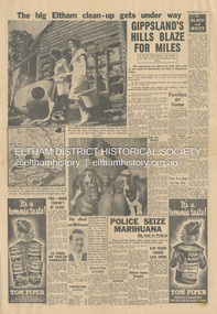 Eltham District Historical Society Inc
Newspaper - News Clipping, Herald, The big Eltham clean-up gets under way, Herald, 4 March, p3, 1965
Full page newspaper clipping featuring the March 1965 Victorian bushfires. Items include: Photograph - TWO-WOMAN BUCKET BRIGADE, Mrs Henry Marsden (left) and Mrs Moureen Ellis, whose fire-fighting efforts yesterday were highly praised today by their Eltham neighbours, carry out mopping-up operations Photograph - DOGS MADE HOMELESS by the fire in North Eltham yesterday are being cared for at First-Constable Doug. Mummery's kennels at Eltham and here is kennel maid Helen Oliver, 17, with some of them today. The two basset hounds are owned by Mr Bill Guy who lost about 100 daschund and basset hound puppies and dogs in the fire. Photograph - He died at Eltham [Picture of John Lawrence Coleman] Builder Mr John Lawrence Coleman, 31, of Main Rd., Eltham, one of three men burnt to death yesterday in the fire at North Eltham. The other two were XXXXX, 33 who lives opposite the Colemans and Mr William Elwers, 64 of Batman Rd., Eltham. John Lawrence Coleman (1934-1965) born January 10, was the son of Raymond John Coleman and Hanna May (Gillet) Coleman. He married Margaret Frances Dare in 1955 and was the father of two children. He died whilst attempting to rescue an older man trapped in the bushfire at North Eltham on March 3, 1965 Other news stories of the day: Bushfires rage in Victoria, Snowy: Three dead (1965, March 4). The Canberra Times (ACT : 1926 - 1995), p. 1. Retrieved May 19, 2022, from http://nla.gov.au/nla.news-article131758981 Includes two photos of the fire in North Eltham “Firemen make for safety as fire rages in Upper Glen Park Road, North Eltham, Victoria. The smoke hides a house.” and “A house explodes into flames at North Eltham, Victoria. Firemen said bottled gas went up.” Canberra Times (ACT : 1926 - 1995), Thursday 4 March 1965, page 1 ________________________________________ Firemen make for safety as fire rages in Upper Glen Park Road. North Eltham. Victoria. The smoke hides a house. A house explodes into flames at North Eltham. Victoria. Firemen said bottled gas went up. Bushfires rage in Victoria, Snowy: Three dead MELBOURNE, Wednesday.—Three people died today in a bush» fire which raged through North Eltham, about 15 miles from Melbourne. The victims were three men. A fourth man is feared to be dead. Another bushfire. sparked off by the heatwave sizzling over south-eastern Australia, is burning out of control in the Kosciusko State Park, in the Snowy Mountains. Firefighters fear that if it reaches pine forests up the Yarrangobilly River, they will be powerless to stop it. The three victims of the North Eltbam fire were trapped by flames in a valley. Their bodies were found only a few yards apart. They were named by police tonight as Mr. George Crowe, 78, of North Eltham, William John Ewers, 64, and John Laurence Coleman, 31, both of Eltham. The other two have not been identified. They are believed to be a man aged about 40 and an 18-year-old youth. At least 12 homes were destroyed by the fire, the worst in Victoria since 1962, when eight lives were lost and hundreds of homes burnt down at Warrandyte. At one time the township of Eltham was threatened, but a cool change swept in from the south and held back the wall of flames. More than 100 dogs, worth about £4,000, died when the fire raced through two kennels in Short Street, Eltham. and Upper Glen Park Road, North Eltham. A trickle of water Residents ran into the streets as the blaze raced towards their houses. Others frantically dug firebreaks around their homes. Mrs. Sue Recourt wept when firemen arrived while she was vainly trying to stop the flames with a trickle of water from the garden hose. A stack of firewood was blazing, but the firemen managed to save the house and rescue four goats. Many homes in Eltham were saved after flames had crept to within feet of their fences. Students at North Eltham State School had to be evacuated when the blaze threatened the building. Fire fighters were severely hampered by lack of water and narrow roads. The blaze, which began in above century heat, turned toward Wattle Glen, where two houses were gutted. Then the flames raced towards Hurstbridge to the north. Firemen battling desperately, controlled the fire late this afternoon. Five forest fires were still burning in Victoria tonight. IN VICTORIA THIS WEEK Tragic lack of central fire authority (1965, March 9). The Canberra Times (ACT : 1926 - 1995), p. 2. Retrieved May 19, 2022, from http://nla.gov.au/nla.news-article131759928 Canberra Times (ACT : 1926 - 1995), Tuesday 9 March 1965, page 2 ________________________________________ IN VICTORIA THIS WEEK Tragic lack of central fire authority From Rohan Rivett It was the worst week for Victorian fire fighters since Black Friday 27 years ago. On that day one pilot up in a spotter plane said afterwards: "It seemed at times that half the State was on fire." This time, for three days on end, Gippsland men, women and children had moments of conviction that their towns would have blackened into anonymity before the weekend was out. The week began with horror at Eltham on the North-eastern edge of Melbourne. Eltham today is something of an artists' colony. Oil painters, water colourists, potters and sculptors proliferate. A number of University folk have emulated the example of Professor MacMahon Ball who pioneered the way by moving to Eltham and carving a home out of the bush in the thirties. Innermost Eltham is barely 14 miles from the G.P.O. Farthest Eltham stretches miles beyond. It served to illustrate the tragi-ludicrous truncation of Victoria's fire control. Part of Eltham is under the protection of the Melbourne Fire Brigade. But this responsibility ceases at some invisible and incomprehensible line — apparently determined by the meanderings of the water mains. At this point everybody's property throughout the rest of Eltham is dependent on the Country Fire Authority. Half an hour before midday on Wednesday, a fire suddenly started on the West side of Upper Glen road on the edge of Eltham. Before the fire brigade could arrive, it was burning on a widening front through timber and high grass north of Eltham. Two wind changes in rapid succession saw the fire leaping Diamond Creek. With a freshening wind it struck home after home in three streets. More than one of them exploded suddenly as if hit by an incendiary bomb. There is no piped gas in the Eltham area, hence many housewives use bottle gas. The flames outside caused the bottles to explode. Altogether twelve homes were completely incinerated and four more were badly damaged. Thirty prize dogs perished. About three hours after the fire started it raced suddenly down a gully hillside trapping an elderly man. Two other men apparently raced to the rescue. Flames caught the three men within yards of each other, not 200 yards off the Upper Glen Park Road where safety lay. They were burned to death. Next evening an angry and convincing secretary of the Fire Brigade Union, Mr. W. M. Webber, came on television and appealed to the people of Victoria to end the ridiculous and dangerous dualism in fire-fighting control. The Eltham fire, he said, had precisely illustrated the situation. The Metropolitan Fire Brigade area touched Eltham, but where the fire had gutted and killed, was just outside its area. Mr. Webber said his union had constantly urged one authority for the State with a complete reorganisation of fire protection. On Wednesday the union had repeated its call for an inquiry into fire protection in Victoria to the Chief Secretary, Mr Rylah. "No matter how close the liaison between the two organisations, there are always divided sections of thinking," Mr. Webber told viewers. "I don't know how much tragedy the com-munity can take before it demands that it is properly protected." Rumours that differences in gauge between taps and hose nozzles (as between the two authorities) accentuated the damage were denied by fire chiefs who said that all appliances were now carrying adaptors so that hoses could be linked to mains everywhere. But there is grave concern in the Metropolitan Fire Brigade's higher councils at the action of several Federal authorities with projects in and around Melbourne. They are installing non-standard equipment without reference to the State authorities or any dovetailing of appliances and equipment. Public alarm was not diminished by the publication on Friday and Saturday of a heart tearing letter from the young widow of John Lawrence Coleman, 31 year old father of two, who had died in the flames apparently trying to rescue the old man trapped in the gully. By that time, a Vast area of Gippsland was in flames and the troops had been sent in to back up the overworked and often helpless fire-fighters. By Saturday, the Leader of the Opposition, Mr. Stoneham, who has previously demanded a Royal Commission into fire-fighting arrangements, repeated his demand. To add to the Chief Secretary's worries he was publicly rebuked for allegedly implying on television that lives had been lost at Eltham because people went to the wrong place at the wrong time. In a letter to the Press, Professor MacMahon Ball pointed out that two of the men involved were experienced bushmen who had gone "to help an old man in great danger fully aware of the danger to themselves". As Victoria faced its sixth day of total State-wide fire ban, it looked likely that even official resistance was not going to silence the demand for one central authority to control the fire fiend. At the moment, the 400 square miles where two million Victorians live in Greater Melbourne are divorced from the rest of the State in planning, communications, equipment and control of personnel. No one doubts the whole-hearted co-operation and willingness to back each other up of the M.F.B. and the C.F.A., both at top-level and among the firemen themselves. However, when a city straggles so deeply into the country side, the absence of a single authority, to oversee and analyse the fire threat as a whole, suggests suicidal policy of divide and fuel. Emphasis of the tragic loss of a member of a pioneering family who died whilst helping others in his communitybushfire, cfa, country fire authority, fire brigrade, glen park road, heroes, john lawrence coleman, north eltham, victorian bushfires - 1965, volunteers, william john elwers, fire fighter, frank martin, george john crowe, ken gaston, orchard avenue, doug mummery, helen oliver, mrs henry marsden, mrs moureen ellis -
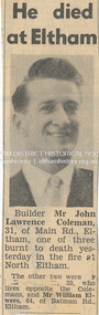 Eltham District Historical Society Inc
Newspaper - News Clipping, Herald, He died at Eltham. Herald, March 4, p3, 4 Mar 1965
John Lawrence Coleman (1934-1965) born January 10, was the son of Raymond John Coleman and Hanna May (Gillet) Coleman. He married Margaret Frances Dare in 1955 and was the father of two children. He died whilst attempting to rescue an older man trapped in the bushfire at North Eltham on March 3, 1965 He died at Eltham (Herald, 4 March 1965, p3) [Picture of John Lawrence Coleman] Builder Mr John Lawrence Coleman, 31, of Main Rd., Eltham, one of three men burnt to death yesterday in the fire at North Eltham. The other two were XXXXX, 33 who lives opposite the Colemans and Mr William Elwers, 64 of Batman Rd., Eltham. * * * Frank Martin was a volunteer with the Eltham rural fire brigade at the time of the 1965 bushfires which burnt Eltham North and Research. Frank was asked to assist with the removal of three bodies from the back gully (now Orchard Avenue). They were badly burnt and one was found stuck under a fence as though trying to escape. Volunteers John Coleman Jnr, William Elwers and George Crowe were killed trying to protect Eltham from bushfire – they were local heroes. At the time, John Coleman Jnr was survived by his wife Margaret and two young children – John 11 and Vicky 2. Margaret Coleman lived in the family home until 1992 when she sold it and moved to Tasmania to be close to her son. She died in 1997 aged 65 years. 75 yr old Ken Gaston grew up on Edendale farm, which was originally a poultry farm but is now owned and run by the Shire of Nillumbik as an educational farm for schools and visitors. He was Captain of the Eltham rural fire brigade in 1965 when John Coleman Jnr was burnt to death in the Eltham North bushfires serving as an unofficial volunteer. He was able to draw where the original Wattletree Road was and at the time was verified with the location of some remaining bitumen and a post from the original bridge over the Diamond Creek located near the junction of the Diamond Creek and another small creek which is further down from Research or Christmas Creek as locals refer to it. The original Main Road ran behind Colemans before the railway line was built beyond Eltham in 1912. (Information recorded by Harry Gilham, President EDHS c.2011) * * * Bushfires rage in Victoria, Snowy: Three dead (1965, March 4). The Canberra Times (ACT : 1926 - 1995), p. 1. Retrieved May 19, 2022, from http://nla.gov.au/nla.news-article131758981 Includes two photos of the fire in North Eltham “Firemen make for safety as fire rages in Upper Glen Park Road, North Eltham, Victoria. The smoke hides a house.” and “A house explodes into flames at North Eltham, Victoria. Firemen said bottled gas went up.” Canberra Times (ACT : 1926 - 1995), Thursday 4 March 1965, page 1 ________________________________________ Firemen make for safety as fire rages in Upper Glen Park Road. North Eltham. Victoria. The smoke hides a house. A house explodes into flames at North Eltham. Victoria. Firemen said bottled gas went up. Bushfires rage in Victoria, Snowy: Three dead MELBOURNE, Wednesday.—Three people died today in a bush» fire which raged through North Eltham, about 15 miles from Melbourne. The victims were three men. A fourth man is feared to be dead. Another bushfire. sparked off by the heatwave sizzling over south-eastern Australia, is burning out of control in the Kosciusko State Park, in the Snowy Mountains. Firefighters fear that if it reaches pine forests up the Yarrangobilly River, they will be powerless to stop it. The three victims of the North Eltbam fire were trapped by flames in a valley. Their bodies were found only a few yards apart. They were named by police tonight as Mr. George Crowe, 78, of North Eltham, William John Ewers, 64, and John Laurence Coleman, 31, both of Eltham. The other two have not been identified. They are believed to be a man aged about 40 and an 18-year-old youth. At least 12 homes were destroyed by the fire, the worst in Victoria since 1962, when eight lives were lost and hundreds of homes burnt down at Warrandyte. At one time the township of Eltham was threatened, but a cool change swept in from the south and held back the wall of flames. More than 100 dogs, worth about £4,000, died when the fire raced through two kennels in Short Street, Eltham. and Upper Glen Park Road, North Eltham. A trickle of water Residents ran into the streets as the blaze raced towards their houses. Others frantically dug firebreaks around their homes. Mrs. Sue Recourt wept when firemen arrived while she was vainly trying to stop the flames with a trickle of water from the garden hose. A stack of firewood was blazing, but the firemen managed to save the house and rescue four goats. Many homes in Eltham were saved after flames had crept to within feet of their fences. Students at North Eltham State School had to be evacuated when the blaze threatened the building. Fire fighters were severely hampered by lack of water and narrow roads. The blaze, which began in above century heat, turned toward Wattle Glen, where two houses were gutted. Then the flames raced towards Hurstbridge to the north. Firemen battling desperately, controlled the fire late this afternoon. Five forest fires were still burning in Victoria tonight. IN VICTORIA THIS WEEK Tragic lack of central fire authority (1965, March 9). The Canberra Times (ACT : 1926 - 1995), p. 2. Retrieved May 19, 2022, from http://nla.gov.au/nla.news-article131759928 Canberra Times (ACT : 1926 - 1995), Tuesday 9 March 1965, page 2 ________________________________________ IN VICTORIA THIS WEEK Tragic lack of central fire authority From Rohan Rivett It was the worst week for Victorian fire fighters since Black Friday 27 years ago. On that day one pilot up in a spotter plane said afterwards: "It seemed at times that half the State was on fire." This time, for three days on end, Gippsland men, women and children had moments of conviction that their towns would have blackened into anonymity before the weekend was out. The week began with horror at Eltham on the North-eastern edge of Melbourne. Eltham today is something of an artists' colony. Oil painters, water colourists, potters and sculptors proliferate. A number of University folk have emulated the example of Professor MacMahon Ball who pioneered the way by moving to Eltham and carving a home out of the bush in the thirties. Innermost Eltham is barely 14 miles from the G.P.O. Farthest Eltham stretches miles beyond. It served to illustrate the tragi-ludicrous truncation of Victoria's fire control. Part of Eltham is under the protection of the Melbourne Fire Brigade. But this responsibility ceases at some invisible and incomprehensible line — apparently determined by the meanderings of the water mains. At this point everybody's property throughout the rest of Eltham is dependent on the Country Fire Authority. Half an hour before midday on Wednesday, a fire suddenly started on the West side of Upper Glen road on the edge of Eltham. Before the fire brigade could arrive, it was burning on a widening front through timber and high grass north of Eltham. Two wind changes in rapid succession saw the fire leaping Diamond Creek. With a freshening wind it struck home after home in three streets. More than one of them exploded suddenly as if hit by an incendiary bomb. There is no piped gas in the Eltham area, hence many housewives use bottle gas. The flames outside caused the bottles to explode. Altogether twelve homes were completely incinerated and four more were badly damaged. Thirty prize dogs perished. About three hours after the fire started it raced suddenly down a gully hillside trapping an elderly man. Two other men apparently raced to the rescue. Flames caught the three men within yards of each other, not 200 yards off the Upper Glen Park Road where safety lay. They were burned to death. Next evening an angry and convincing secretary of the Fire Brigade Union, Mr. W. M. Webber, came on television and appealed to the people of Victoria to end the ridiculous and dangerous dualism in fire-fighting control. The Eltham fire, he said, had precisely illustrated the situation. The Metropolitan Fire Brigade area touched Eltham, but where the fire had gutted and killed, was just outside its area. Mr. Webber said his union had constantly urged one authority for the State with a complete reorganisation of fire protection. On Wednesday the union had repeated its call for an inquiry into fire protection in Victoria to the Chief Secretary, Mr Rylah. "No matter how close the liaison between the two organisations, there are always divided sections of thinking," Mr. Webber told viewers. "I don't know how much tragedy the com-munity can take before it demands that it is properly protected." Rumours that differences in gauge between taps and hose nozzles (as between the two authorities) accentuated the damage were denied by fire chiefs who said that all appliances were now carrying adaptors so that hoses could be linked to mains everywhere. But there is grave concern in the Metropolitan Fire Brigade's higher councils at the action of several Federal authorities with projects in and around Melbourne. They are installing non-standard equipment without reference to the State authorities or any dovetailing of appliances and equipment. Public alarm was not diminished by the publication on Friday and Saturday of a heart tearing letter from the young widow of John Lawrence Coleman, 31 year old father of two, who had died in the flames apparently trying to rescue the old man trapped in the gully. By that time, a Vast area of Gippsland was in flames and the troops had been sent in to back up the overworked and often helpless fire-fighters. By Saturday, the Leader of the Opposition, Mr. Stoneham, who has previously demanded a Royal Commission into fire-fighting arrangements, repeated his demand. To add to the Chief Secretary's worries he was publicly rebuked for allegedly implying on television that lives had been lost at Eltham because people went to the wrong place at the wrong time. In a letter to the Press, Professor MacMahon Ball pointed out that two of the men involved were experienced bushmen who had gone "to help an old man in great danger fully aware of the danger to themselves". As Victoria faced its sixth day of total State-wide fire ban, it looked likely that even official resistance was not going to silence the demand for one central authority to control the fire fiend. At the moment, the 400 square miles where two million Victorians live in Greater Melbourne are divorced from the rest of the State in planning, communications, equipment and control of personnel. No one doubts the whole-hearted co-operation and willingness to back each other up of the M.F.B. and the C.F.A., both at top-level and among the firemen themselves. However, when a city straggles so deeply into the country side, the absence of a single authority, to oversee and analyse the fire threat as a whole, suggests suicidal policy of divide and fuel. Emphasis of the tragic loss of a member of a pioneering family who died whilst helping others in his communitybushfire, cfa, country fire authority, fire brigrade, glen park road, heroes, john lawrence coleman, north eltham, victorian bushfires - 1965, volunteers, william john elwers, fire fighter, frank martin, george john crowe, ken gaston, orchard avenue -
 Eltham District Historical Society Inc
Photograph - Aerial Photograph, Landata, Eltham; Crown Allotment 15, Section 5, Parish of Nillumbik (Stokes Orchard Estate), Dec. 1945
Centred on present day Diosma Rd, Stokes Pl, Nyora Rd and Eucalyptus Rd Historic Aerial Imagery Source: Landata.vic.gov.au Aerial Photo Details: Project No :5 Project : MELBOURNE AND METROPOLITAN AREA PROJECT Run : 36 Frame : 60546 Date : 12/1945 Film Type : B/W Camera : EAG4 Flying Height : 10200 Scale : 6000 Film Number : 195 GDA2020 : 37°42'47"S, 145°09'56"E MGA2020 : 338306, 5824438 (55) Melways : 22 C4 (ed. 42) A History of the Development of Crown Allotment 15, Section 5, Parish of Nillumbik – Stokes Orchard Crown Allotment 15, Section 5, Parish of Nillumbik (CA15) is a square allotment of 158 acres or approximately a quarter of a square mile. It lies just beyond the eastern end of Pitt Street, south of Nyora Road to the northern end of Eucalyptus Road and extends east from Eucalyptus Road to Reynolds Road. The topography of CA15 is generally steep, sloping up to a hill near the centre of the land, the ridgeline passing through the properties along the southern side of Diosma Road. Eucalyptus Road is a straight north-south road with its northern end at the north west corner of CA15. Until the end of the 1970s this road was an un-named Government Road and was largely not open to traffic. With residential development in the 1970s the road was constructed, and the council allocated the name obviously in recognition of the predominant species of the local bushland. CA15 was purchased from the Crown by George D’Arley Boursiquot, a prominent Melbourne printer, on 28th October 1852. On November 23, 1922, former Member for Gippsland and Melbourne Real Estate Agent, Hubert Patrick Keogh purchased the allotment then sold it March 13, 1925, to local farmer, Robert David Taylor, a former Shire of Eltham Councillor (1911-1920) and Shire President (1919). Taylor had extensive land holdings stretching west towards Bible Street and Main Road. The Taylor home was situated at the top of the hill in Bible Street at present day 82 Bible Street. At the time of Taylor’s purchase in 1925, CA15 was subdivided into 48 lots that could be described as small rural properties or large residential lots. A typical lot size was one hectare or 2.5 acres. The subdivision created two roads, Nyora Road, and Diosma Road, each following an irregular alignment between Eucalyptus and Reynolds Roads. However, the lots were not sold off separately nor were the roads constructed. The land effectively remained as one parcel for many further years. Robert David Taylor died November 30, 1934, and probate was granted to his son of the same name, Robert David Taylor of Bible Street, Salesman and William McLelland Vance Taylor of 73 Emmeline Street, Northcote, Clerk, with the transfer of the land into their names on July 8, 1935. Frank Stokes worked as a qualified accountant at Kennons leather factory in Burnley, while living at 1 Thomas Street, Mitcham. He suffered from migraines and wanted to return to working the land (he had previously worked on farms and orchards since coming to Australia from England in 1926, both in WA and Vic.). He first travelled to the district by train in July 1942 to find land with the intention to establish an orchard. By chance he met Arthur Bird of Bird Orchard (bounded by Pitt Street, Eucalyptus Road, and Wattle Grove) and they got talking over their common interest. Arthur put Frank up for the night and pointed out the land, 158 acres- part of the Taylor Estate- £900, Crown Allotment 15, Section 5, Parish of Nillumbik (CA15) somewhat diagonally opposite Bird Orchard. Stokes applied through the Riverina Agency to purchase the land who in turn applied for permission from Canberra to sell as there was a new government regulation introduced during the Second World War banning land sales except for immediate production. Stokes obtained a loan on his Mitcham house of £600 @ 5% and paid £450 deposit with quarterly payments of £15 spread over 5 years. Stokes was assisted and advised by Arthur Bird who farmed the neighbouring orchard. In early 1943 Stokes took possession and would catch the train out to Eltham on Fridays after work and began building a hut on the corner of Nyora Road and the Government Road (Eucalyptus Road) for shelter and to lock up tools. He established an orchard on the central western part of the land through the centre of which ran a natural waterway (part of the present-day linear park) and was able to pay a neighbour (Hawkins) to help with clearing and fencing 25 acres, and with a horse and single furrowed plough, planted approximately 2,500 fruit trees - cherries, peaches, plums, almonds, pears, apricots and lemons as well as a few apples and oranges; a massive task. Aerial photographs from the 1940s through to the 1990s clearly show the orchard with most of the larger CA15 site remaining as natural bushland. A huge problem was hares and rabbits eating all the new buds off the tiny trees. As well as laying poison he painted the trees with a mixture of cow manure and lime, often working by moonlight. Procurement of wire and wire netting was difficult because of the war but after much effort he obtained a permit from the Agricultural Department for supplies in March 1944. In February 1945 Stokes applied for a permit to build a “packing shed” as no house building was allowed. It was to be 33 feet x 21 feet and cost £312. It was constructed mostly from second-hand materials, which were hard to obtain, especially iron for roofing. Stokes finished work at Kennons on October 31, 1945, and in March 1946 he sold the family home at Mitcham for £1,230 plus £170 for furniture. On May 15, 1946, title to the CA15 property was issued to Frank Howard Alfred Stokes, Orchardist and Gladys Ethel Stokes, Married Woman, both of Pitt Street, Eltham. The family of five then moved into the very unfinished “packing shed” at Eltham, which was a struggle to weatherproof. Eventually rooms were divided off and lined with hessian bags and whitewashed. Their income was firewood (cut and sold), selling rockery stones and cut Sweet Bursaria. (It was discovered during the 1940s that Sweet Bursaria contained the sunscreen compound Aesculin. The RAAF utilised this compound from Sweet Bursaria during WW2 for pilots and gunners.) The orchard’s first fruit sale was a half-case of Le Vanq peaches in December 1947 for the price of 8 shillings. In 1956 plans for house were drawn and Glen Iris bricks purchased (1956 Olympic Rings variant). The building of the house commenced in 1957 - 12 feet of original packing shed was removed – and was completed in 1959. Water was connected from newly built pressure storage on the property at the end of 1959 and the electricity connection for the first time at 3pm on April 29, 1960. The house remains to present day (somewhat modified) at 1 Nyora Road, home to Nyora Studio Gallery. On occasions, spare remnants of the 1956 bricks have been known to be unearthed in gardens on the estate as they were utilised by Frank Stokes to fill in rabbit holes. On May 26, 1950, a parcel of land was compulsorily acquired by the Melbourne and Metropolitan Board of Works on the hilltop to establish an easement for a high-level service reservoir to augment Eltham’s water supply. The project also included pipe tracks for the necessary water mains. The reservoir has now been superseded by higher level water tanks east of Reynolds Road and its former site is now a public reserve. On November 27, 1964, the State Electricity Commission served notice to compulsorily acquire a further parcel through the eastern part of the land for a major electricity transmission line that augmented supply from the La Trobe Valley to Melbourne. The easement was registered February 11, 1966. The easement was widened July 18, 1969 for a second transmission line to be constructed. In 1971 Melbourne Metropolitan Planning Scheme amendments adopted Nyora Road as the boundary between a residential zone to the north and a rural zone to the south. This determined the future development of the land. In the mid-1970s the Shire of Eltham divided the orchard into numerous rate-able parcel lots, the 48 lots having been established in 1925 and the subsequent rates assessment proved unsustainable for Stokes. He commenced selling lots outside the boundary of the orchard, north of Diosma and South of Nyora. However shortly later the land between Nyora and Diosma Roads and west of the electricity easement was sold and subdivided into residential lots, a housing development by Macquarie Builders and marketed as the Stokes Orchard Estate. New streets were created, and most were named after trees, although one, Stokes Place, commemorates the former owners. The development was undertaken in two stages; Stage 1 (1975) encompassing Scarlet Ash Court, Ironbark Close and Peppermint Grove bounded by Nyora and Eucalyptus roads and Stage 2 (1978) encompassing Stokes Place, Orchard Way, The Crest and The Lookout bound by Nyora and Diosma roads. The developer, Macquarie Builders went bankrupt shortly after the release of Stage 2 leaving many purchasers to fend for themselves and arrange for their own independent builders. There were also difficulties with sewerage for the land immediately south of Diosma Road and so the conventional residential lots were abandoned in favour of larger lots. The development of Orchard Way, The Crest and The Lookout did not proceed as planned and the proposed lots were incorporated into five-acre parcels instead. These included a low-density group housing development by the Graves family and the award winning Choong House (1983) with Gordon Ford developed garden immediately next door situated on the ridge of the hill nestled amongst the original bush, Eucalypt trees and Sweet Bursaria. In 1994, Nillumbik Shire Council applied Significant Environment and Significant Landscape overlays upon the properties on the south side of Diosma Road to ensure protection of this natural bush garden environment. With the arrival of the sewer along Diosma Road in the 1990s, most of these five-acre parcels have since been subdivided multiple times. The Choong house presently sits on a 2.7-acre property, which in 2022 Nillumbik Council nominated for Cultural Significance Heritage protection and is considered potentially significant at State level. The Stokes family were also associated with the Eltham Christian Church. In the 1970s this church had met in temporary premises in Eltham. Lots of the original 1925 subdivision remained south of Nyora Road and a number of these lots were utilized for the Eltham Christian School, which was established by the Eltham Christian Church in 1981. The school operated on this site until 2000. The premises are now used by The Vine Baptist Church. By the mid-1980s the whole of CA15 had been developed for residential and school purposes, except for the sections north of Diosma Road and between the transmission lines and Reynolds Road. Sewerage issues had been resolved for the section north of Diosma Road and in 1987 it was in the process of being subdivided into residential lots. The development coincided with the discovery of colonies of the rare and endangered Eltham Copper Butterfly on the site. This resulted in a community and political campaign to save the butterfly habitat. With the co-operation of the land developer the subdivision was altered to create two bushland reserves in the critical butterfly habitat areas. In the late 1980s the State Government was investigating options for establishing a metropolitan ring road link between Diamond Creek and Ringwood. The chosen route was adjacent to Reynolds Road and so this created a freeze on development of CA15 between Reynolds Road and the electricity easement. The ring road proposal was eventually abandoned, and this part of the land was subdivided into low density residential lots. Diosma Road has been discontinued at the electricity easement and the eastern part incorporated into View Mount Court with access from Reynolds Road. The whole of CA15 has now been developed for residential or associated purposes, ranging from conventional density to quite low density south of Nyora Road. Some remnants of the orchard remain, a few cherry trees on the Graves property and a lone apple tree in Stokes Place. The butterfly reserves comprise significant areas of remnant bushland. Linear reserves through the estate link with central Eltham via the Woodridge linear reserve and with Research along the electricity easement. CA15 as it exists today has a complicated history of rural use, Government acquisition, urban development, and community action. References: • “Stokes Orchard, an incomplete history”; Russell Yeoman with Doug Orford • Correspondence, Beryl Bradbury (nee Stokes) • Aerial Photographs, 1931-1991, Landata (landata.vic.gov.au) • Certificate of Title, Vol. 4930 Fol. 985900 • Plan Number LP 10859 aerial photo, diosma road, eltham copper butterfly, eucalyptus road, ironbark close, nyora road, peppermint grove, peter & elizabeth pidgeon collection, power transmission lines, reynolds road, scarlet ash court, stokes orchard estate, stokes place, woodridge estate, frank stokes -
 Eltham District Historical Society Inc
Photograph - Aerial Photograph, Landata, Eltham; Crown Allotment 15, Section 5, Parish of Nillumbik (Stokes Orchard Estate), Nov. 1931
Centred over present day Reynolds Road and Mount Pleasant Road, Eltham (including Diosma Rd, Stokes Pl, Nyora Rd and Eucalyptus Rd) Historic Aerial Imagery Source: Landata.vic.gov.au Aerial Photo Details: Project No :1931 Project : MALDON PRISON Run : 21 Frame : 3160 Date : 11/1931 Film Type : B/W Camera : F8 Flying Height : 11000 Scale : 18860 Film Number : 60 GDA2020 : 37°43'31"S, 145°10'20"E MGA2020 : 338912, 5823086 (55) Melways : 22 E8 (ed. 42) A History of the Development of Crown Allotment 15, Section 5, Parish of Nillumbik – Stokes Orchard Crown Allotment 15, Section 5, Parish of Nillumbik (CA15) is a square allotment of 158 acres or approximately a quarter of a square mile. It lies just beyond the eastern end of Pitt Street, south of Nyora Road to the northern end of Eucalyptus Road and extends east from Eucalyptus Road to Reynolds Road. The topography of CA15 is generally steep, sloping up to a hill near the centre of the land, the ridgeline passing through the properties along the southern side of Diosma Road. Eucalyptus Road is a straight north-south road with its northern end at the north west corner of CA15. Until the end of the 1970s this road was an un-named Government Road and was largely not open to traffic. With residential development in the 1970s the road was constructed, and the council allocated the name obviously in recognition of the predominant species of the local bushland. CA15 was purchased from the Crown by George D’Arley Boursiquot, a prominent Melbourne printer, on 28th October 1852. On November 23, 1922, former Member for Gippsland and Melbourne Real Estate Agent, Hubert Patrick Keogh purchased the allotment then sold it March 13, 1925, to local farmer, Robert David Taylor, a former Shire of Eltham Councillor (1911-1920) and Shire President (1919). Taylor had extensive land holdings stretching west towards Bible Street and Main Road. The Taylor home was situated at the top of the hill in Bible Street at present day 82 Bible Street. At the time of Taylor’s purchase in 1925, CA15 was subdivided into 48 lots that could be described as small rural properties or large residential lots. A typical lot size was one hectare or 2.5 acres. The subdivision created two roads, Nyora Road, and Diosma Road, each following an irregular alignment between Eucalyptus and Reynolds Roads. However, the lots were not sold off separately nor were the roads constructed. The land effectively remained as one parcel for many further years. Robert David Taylor died November 30, 1934, and probate was granted to his son of the same name, Robert David Taylor of Bible Street, Salesman and William McLelland Vance Taylor of 73 Emmeline Street, Northcote, Clerk, with the transfer of the land into their names on July 8, 1935. Frank Stokes worked as a qualified accountant at Kennons leather factory in Burnley, while living at 1 Thomas Street, Mitcham. He suffered from migraines and wanted to return to working the land (he had previously worked on farms and orchards since coming to Australia from England in 1926, both in WA and Vic.). He first travelled to the district by train in July 1942 to find land with the intention to establish an orchard. By chance he met Arthur Bird of Bird Orchard (bounded by Pitt Street, Eucalyptus Road, and Wattle Grove) and they got talking over their common interest. Arthur put Frank up for the night and pointed out the land, 158 acres- part of the Taylor Estate- £900, Crown Allotment 15, Section 5, Parish of Nillumbik (CA15) somewhat diagonally opposite Bird Orchard. Stokes applied through the Riverina Agency to purchase the land who in turn applied for permission from Canberra to sell as there was a new government regulation introduced during the Second World War banning land sales except for immediate production. Stokes obtained a loan on his Mitcham house of £600 @ 5% and paid £450 deposit with quarterly payments of £15 spread over 5 years. Stokes was assisted and advised by Arthur Bird who farmed the neighbouring orchard. In early 1943 Stokes took possession and would catch the train out to Eltham on Fridays after work and began building a hut on the corner of Nyora Road and the Government Road (Eucalyptus Road) for shelter and to lock up tools. He established an orchard on the central western part of the land through the centre of which ran a natural waterway (part of the present-day linear park) and was able to pay a neighbour (Hawkins) to help with clearing and fencing 25 acres, and with a horse and single furrowed plough, planted approximately 2,500 fruit trees - cherries, peaches, plums, almonds, pears, apricots and lemons as well as a few apples and oranges; a massive task. Aerial photographs from the 1940s through to the 1990s clearly show the orchard with most of the larger CA15 site remaining as natural bushland. A huge problem was hares and rabbits eating all the new buds off the tiny trees. As well as laying poison he painted the trees with a mixture of cow manure and lime, often working by moonlight. Procurement of wire and wire netting was difficult because of the war but after much effort he obtained a permit from the Agricultural Department for supplies in March 1944. In February 1945 Stokes applied for a permit to build a “packing shed” as no house building was allowed. It was to be 33 feet x 21 feet and cost £312. It was constructed mostly from second-hand materials, which were hard to obtain, especially iron for roofing. Stokes finished work at Kennons on October 31, 1945, and in March 1946 he sold the family home at Mitcham for £1,230 plus £170 for furniture. On May 15, 1946, title to the CA15 property was issued to Frank Howard Alfred Stokes, Orchardist and Gladys Ethel Stokes, Married Woman, both of Pitt Street, Eltham. The family of five then moved into the very unfinished “packing shed” at Eltham, which was a struggle to weatherproof. Eventually rooms were divided off and lined with hessian bags and whitewashed. Their income was firewood (cut and sold), selling rockery stones and cut Sweet Bursaria. (It was discovered during the 1940s that Sweet Bursaria contained the sunscreen compound Aesculin. The RAAF utilised this compound from Sweet Bursaria during WW2 for pilots and gunners.) The orchard’s first fruit sale was a half-case of Le Vanq peaches in December 1947 for the price of 8 shillings. In 1956 plans for house were drawn and Glen Iris bricks purchased (1956 Olympic Rings variant). The building of the house commenced in 1957 - 12 feet of original packing shed was removed – and was completed in 1959. Water was connected from newly built pressure storage on the property at the end of 1959 and the electricity connection for the first time at 3pm on April 29, 1960. The house remains to present day (somewhat modified) at 1 Nyora Road, home to Nyora Studio Gallery. On occasions, spare remnants of the 1956 bricks have been known to be unearthed in gardens on the estate as they were utilised by Frank Stokes to fill in rabbit holes. On May 26, 1950, a parcel of land was compulsorily acquired by the Melbourne and Metropolitan Board of Works on the hilltop to establish an easement for a high-level service reservoir to augment Eltham’s water supply. The project also included pipe tracks for the necessary water mains. The reservoir has now been superseded by higher level water tanks east of Reynolds Road and its former site is now a public reserve. On November 27, 1964, the State Electricity Commission served notice to compulsorily acquire a further parcel through the eastern part of the land for a major electricity transmission line that augmented supply from the La Trobe Valley to Melbourne. The easement was registered February 11, 1966. The easement was widened July 18, 1969 for a second transmission line to be constructed. In 1971 Melbourne Metropolitan Planning Scheme amendments adopted Nyora Road as the boundary between a residential zone to the north and a rural zone to the south. This determined the future development of the land. In the mid-1970s the Shire of Eltham divided the orchard into numerous rate-able parcel lots, the 48 lots having been established in 1925 and the subsequent rates assessment proved unsustainable for Stokes. He commenced selling lots outside the boundary of the orchard, north of Diosma and South of Nyora. However shortly later the land between Nyora and Diosma Roads and west of the electricity easement was sold and subdivided into residential lots, a housing development by Macquarie Builders and marketed as the Stokes Orchard Estate. New streets were created, and most were named after trees, although one, Stokes Place, commemorates the former owners. The development was undertaken in two stages; Stage 1 (1975) encompassing Scarlet Ash Court, Ironbark Close and Peppermint Grove bounded by Nyora and Eucalyptus roads and Stage 2 (1978) encompassing Stokes Place, Orchard Way, The Crest and The Lookout bound by Nyora and Diosma roads. The developer, Macquarie Builders went bankrupt shortly after the release of Stage 2 leaving many purchasers to fend for themselves and arrange for their own independent builders. There were also difficulties with sewerage for the land immediately south of Diosma Road and so the conventional residential lots were abandoned in favour of larger lots. The development of Orchard Way, The Crest and The Lookout did not proceed as planned and the proposed lots were incorporated into five-acre parcels instead. These included a low-density group housing development by the Graves family and the award winning Choong House (1983) with Gordon Ford developed garden immediately next door situated on the ridge of the hill nestled amongst the original bush, Eucalypt trees and Sweet Bursaria. In 1994, Nillumbik Shire Council applied Significant Environment and Significant Landscape overlays upon the properties on the south side of Diosma Road to ensure protection of this natural bush garden environment. With the arrival of the sewer along Diosma Road in the 1990s, most of these five-acre parcels have since been subdivided multiple times. The Choong house presently sits on a 2.7-acre property, which in 2022 Nillumbik Council nominated for Cultural Significance Heritage protection and is considered potentially significant at State level. The Stokes family were also associated with the Eltham Christian Church. In the 1970s this church had met in temporary premises in Eltham. Lots of the original 1925 subdivision remained south of Nyora Road and a number of these lots were utilized for the Eltham Christian School, which was established by the Eltham Christian Church in 1981. The school operated on this site until 2000. The premises are now used by The Vine Baptist Church. By the mid-1980s the whole of CA15 had been developed for residential and school purposes, except for the sections north of Diosma Road and between the transmission lines and Reynolds Road. Sewerage issues had been resolved for the section north of Diosma Road and in 1987 it was in the process of being subdivided into residential lots. The development coincided with the discovery of colonies of the rare and endangered Eltham Copper Butterfly on the site. This resulted in a community and political campaign to save the butterfly habitat. With the co-operation of the land developer the subdivision was altered to create two bushland reserves in the critical butterfly habitat areas. In the late 1980s the State Government was investigating options for establishing a metropolitan ring road link between Diamond Creek and Ringwood. The chosen route was adjacent to Reynolds Road and so this created a freeze on development of CA15 between Reynolds Road and the electricity easement. The ring road proposal was eventually abandoned, and this part of the land was subdivided into low density residential lots. Diosma Road has been discontinued at the electricity easement and the eastern part incorporated into View Mount Court with access from Reynolds Road. The whole of CA15 has now been developed for residential or associated purposes, ranging from conventional density to quite low density south of Nyora Road. Some remnants of the orchard remain, a few cherry trees on the Graves property and a lone apple tree in Stokes Place. The butterfly reserves comprise significant areas of remnant bushland. Linear reserves through the estate link with central Eltham via the Woodridge linear reserve and with Research along the electricity easement. CA15 as it exists today has a complicated history of rural use, Government acquisition, urban development, and community action. References: • “Stokes Orchard, an incomplete history”; Russell Yeoman with Doug Orford • Correspondence, Beryl Bradbury (nee Stokes) • Aerial Photographs, 1931-1991, Landata (landata.vic.gov.au) • Certificate of Title, Vol. 4930 Fol. 985900 • Plan Number LP 10859 aerial photo, diosma road, eltham copper butterfly, eucalyptus road, ironbark close, nyora road, peppermint grove, peter & elizabeth pidgeon collection, power transmission lines, reynolds road, scarlet ash court, stokes orchard estate, stokes place, woodridge estate, frank stokes -
 Eltham District Historical Society Inc
Photograph - Aerial Photograph, Landata, Eltham; Crown Allotment 15, Section 5, Parish of Nillumbik (Stokes Orchard Estate), Jan. 1951
Centred on present day Diosma Rd, Stokes Pl, Nyora Rd and Eucalyptus Rd Historic Aerial Imagery Source: Landata.vic.gov.au Aerial Photo Details: Project No :65 Project : MELBOURNE AND METROPOLITAN PROJECT NO. 2 Run : 8 Frame : 71 Date : 01/1951 Film Type : B/W Camera : EAG9 Flying Height : 12200 Scale : 12000 Film Number : 1419 GDA2020 : 37°43'14"S, 145°09'46"E MGA2020 : 338081, 5823608 (55) Melways : 22 C6 (ed. 42) A History of the Development of Crown Allotment 15, Section 5, Parish of Nillumbik – Stokes Orchard Crown Allotment 15, Section 5, Parish of Nillumbik (CA15) is a square allotment of 158 acres or approximately a quarter of a square mile. It lies just beyond the eastern end of Pitt Street, south of Nyora Road to the northern end of Eucalyptus Road and extends east from Eucalyptus Road to Reynolds Road. The topography of CA15 is generally steep, sloping up to a hill near the centre of the land, the ridgeline passing through the properties along the southern side of Diosma Road. Eucalyptus Road is a straight north-south road with its northern end at the north west corner of CA15. Until the end of the 1970s this road was an un-named Government Road and was largely not open to traffic. With residential development in the 1970s the road was constructed, and the council allocated the name obviously in recognition of the predominant species of the local bushland. CA15 was purchased from the Crown by George D’Arley Boursiquot, a prominent Melbourne printer, on 28th October 1852. On November 23, 1922, former Member for Gippsland and Melbourne Real Estate Agent, Hubert Patrick Keogh purchased the allotment then sold it March 13, 1925, to local farmer, Robert David Taylor, a former Shire of Eltham Councillor (1911-1920) and Shire President (1919). Taylor had extensive land holdings stretching west towards Bible Street and Main Road. The Taylor home was situated at the top of the hill in Bible Street at present day 82 Bible Street. At the time of Taylor’s purchase in 1925, CA15 was subdivided into 48 lots that could be described as small rural properties or large residential lots. A typical lot size was one hectare or 2.5 acres. The subdivision created two roads, Nyora Road, and Diosma Road, each following an irregular alignment between Eucalyptus and Reynolds Roads. However, the lots were not sold off separately nor were the roads constructed. The land effectively remained as one parcel for many further years. Robert David Taylor died November 30, 1934, and probate was granted to his son of the same name, Robert David Taylor of Bible Street, Salesman and William McLelland Vance Taylor of 73 Emmeline Street, Northcote, Clerk, with the transfer of the land into their names on July 8, 1935. Frank Stokes worked as a qualified accountant at Kennons leather factory in Burnley, while living at 1 Thomas Street, Mitcham. He suffered from migraines and wanted to return to working the land (he had previously worked on farms and orchards since coming to Australia from England in 1926, both in WA and Vic.). He first travelled to the district by train in July 1942 to find land with the intention to establish an orchard. By chance he met Arthur Bird of Bird Orchard (bounded by Pitt Street, Eucalyptus Road, and Wattle Grove) and they got talking over their common interest. Arthur put Frank up for the night and pointed out the land, 158 acres- part of the Taylor Estate- £900, Crown Allotment 15, Section 5, Parish of Nillumbik (CA15) somewhat diagonally opposite Bird Orchard. Stokes applied through the Riverina Agency to purchase the land who in turn applied for permission from Canberra to sell as there was a new government regulation introduced during the Second World War banning land sales except for immediate production. Stokes obtained a loan on his Mitcham house of £600 @ 5% and paid £450 deposit with quarterly payments of £15 spread over 5 years. Stokes was assisted and advised by Arthur Bird who farmed the neighbouring orchard. In early 1943 Stokes took possession and would catch the train out to Eltham on Fridays after work and began building a hut on the corner of Nyora Road and the Government Road (Eucalyptus Road) for shelter and to lock up tools. He established an orchard on the central western part of the land through the centre of which ran a natural waterway (part of the present-day linear park) and was able to pay a neighbour (Hawkins) to help with clearing and fencing 25 acres, and with a horse and single furrowed plough, planted approximately 2,500 fruit trees - cherries, peaches, plums, almonds, pears, apricots and lemons as well as a few apples and oranges; a massive task. Aerial photographs from the 1940s through to the 1990s clearly show the orchard with most of the larger CA15 site remaining as natural bushland. A huge problem was hares and rabbits eating all the new buds off the tiny trees. As well as laying poison he painted the trees with a mixture of cow manure and lime, often working by moonlight. Procurement of wire and wire netting was difficult because of the war but after much effort he obtained a permit from the Agricultural Department for supplies in March 1944. In February 1945 Stokes applied for a permit to build a “packing shed” as no house building was allowed. It was to be 33 feet x 21 feet and cost £312. It was constructed mostly from second-hand materials, which were hard to obtain, especially iron for roofing. Stokes finished work at Kennons on October 31, 1945, and in March 1946 he sold the family home at Mitcham for £1,230 plus £170 for furniture. On May 15, 1946, title to the CA15 property was issued to Frank Howard Alfred Stokes, Orchardist and Gladys Ethel Stokes, Married Woman, both of Pitt Street, Eltham. The family of five then moved into the very unfinished “packing shed” at Eltham, which was a struggle to weatherproof. Eventually rooms were divided off and lined with hessian bags and whitewashed. Their income was firewood (cut and sold), selling rockery stones and cut Sweet Bursaria. (It was discovered during the 1940s that Sweet Bursaria contained the sunscreen compound Aesculin. The RAAF utilised this compound from Sweet Bursaria during WW2 for pilots and gunners.) The orchard’s first fruit sale was a half-case of Le Vanq peaches in December 1947 for the price of 8 shillings. In 1956 plans for house were drawn and Glen Iris bricks purchased (1956 Olympic Rings variant). The building of the house commenced in 1957 - 12 feet of original packing shed was removed – and was completed in 1959. Water was connected from newly built pressure storage on the property at the end of 1959 and the electricity connection for the first time at 3pm on April 29, 1960. The house remains to present day (somewhat modified) at 1 Nyora Road, home to Nyora Studio Gallery. On occasions, spare remnants of the 1956 bricks have been known to be unearthed in gardens on the estate as they were utilised by Frank Stokes to fill in rabbit holes. On May 26, 1950, a parcel of land was compulsorily acquired by the Melbourne and Metropolitan Board of Works on the hilltop to establish an easement for a high-level service reservoir to augment Eltham’s water supply. The project also included pipe tracks for the necessary water mains. The reservoir has now been superseded by higher level water tanks east of Reynolds Road and its former site is now a public reserve. On November 27, 1964, the State Electricity Commission served notice to compulsorily acquire a further parcel through the eastern part of the land for a major electricity transmission line that augmented supply from the La Trobe Valley to Melbourne. The easement was registered February 11, 1966. The easement was widened July 18, 1969 for a second transmission line to be constructed. In 1971 Melbourne Metropolitan Planning Scheme amendments adopted Nyora Road as the boundary between a residential zone to the north and a rural zone to the south. This determined the future development of the land. In the mid-1970s the Shire of Eltham divided the orchard into numerous rate-able parcel lots, the 48 lots having been established in 1925 and the subsequent rates assessment proved unsustainable for Stokes. He commenced selling lots outside the boundary of the orchard, north of Diosma and South of Nyora. However shortly later the land between Nyora and Diosma Roads and west of the electricity easement was sold and subdivided into residential lots, a housing development by Macquarie Builders and marketed as the Stokes Orchard Estate. New streets were created, and most were named after trees, although one, Stokes Place, commemorates the former owners. The development was undertaken in two stages; Stage 1 (1975) encompassing Scarlet Ash Court, Ironbark Close and Peppermint Grove bounded by Nyora and Eucalyptus roads and Stage 2 (1978) encompassing Stokes Place, Orchard Way, The Crest and The Lookout bound by Nyora and Diosma roads. The developer, Macquarie Builders went bankrupt shortly after the release of Stage 2 leaving many purchasers to fend for themselves and arrange for their own independent builders. There were also difficulties with sewerage for the land immediately south of Diosma Road and so the conventional residential lots were abandoned in favour of larger lots. The development of Orchard Way, The Crest and The Lookout did not proceed as planned and the proposed lots were incorporated into five-acre parcels instead. These included a low-density group housing development by the Graves family and the award winning Choong House (1983) with Gordon Ford developed garden immediately next door situated on the ridge of the hill nestled amongst the original bush, Eucalypt trees and Sweet Bursaria. In 1994, Nillumbik Shire Council applied Significant Environment and Significant Landscape overlays upon the properties on the south side of Diosma Road to ensure protection of this natural bush garden environment. With the arrival of the sewer along Diosma Road in the 1990s, most of these five-acre parcels have since been subdivided multiple times. The Choong house presently sits on a 2.7-acre property, which in 2022 Nillumbik Council nominated for Cultural Significance Heritage protection and is considered potentially significant at State level. The Stokes family were also associated with the Eltham Christian Church. In the 1970s this church had met in temporary premises in Eltham. Lots of the original 1925 subdivision remained south of Nyora Road and a number of these lots were utilized for the Eltham Christian School, which was established by the Eltham Christian Church in 1981. The school operated on this site until 2000. The premises are now used by The Vine Baptist Church. By the mid-1980s the whole of CA15 had been developed for residential and school purposes, except for the sections north of Diosma Road and between the transmission lines and Reynolds Road. Sewerage issues had been resolved for the section north of Diosma Road and in 1987 it was in the process of being subdivided into residential lots. The development coincided with the discovery of colonies of the rare and endangered Eltham Copper Butterfly on the site. This resulted in a community and political campaign to save the butterfly habitat. With the co-operation of the land developer the subdivision was altered to create two bushland reserves in the critical butterfly habitat areas. In the late 1980s the State Government was investigating options for establishing a metropolitan ring road link between Diamond Creek and Ringwood. The chosen route was adjacent to Reynolds Road and so this created a freeze on development of CA15 between Reynolds Road and the electricity easement. The ring road proposal was eventually abandoned, and this part of the land was subdivided into low density residential lots. Diosma Road has been discontinued at the electricity easement and the eastern part incorporated into View Mount Court with access from Reynolds Road. The whole of CA15 has now been developed for residential or associated purposes, ranging from conventional density to quite low density south of Nyora Road. Some remnants of the orchard remain, a few cherry trees on the Graves property and a lone apple tree in Stokes Place. The butterfly reserves comprise significant areas of remnant bushland. Linear reserves through the estate link with central Eltham via the Woodridge linear reserve and with Research along the electricity easement. CA15 as it exists today has a complicated history of rural use, Government acquisition, urban development, and community action. References: • “Stokes Orchard, an incomplete history”; Russell Yeoman with Doug Orford • Correspondence, Beryl Bradbury (nee Stokes) • Aerial Photographs, 1931-1991, Landata (landata.vic.gov.au) • Certificate of Title, Vol. 4930 Fol. 985900 • Plan Number LP 10859 aerial photo, diosma road, eltham copper butterfly, eucalyptus road, ironbark close, nyora road, peppermint grove, peter & elizabeth pidgeon collection, power transmission lines, reynolds road, scarlet ash court, stokes orchard estate, stokes place, woodridge estate, frank stokes -
 Eltham District Historical Society Inc
Photograph - Aerial Photograph, Landata, Eltham; Crown Allotment 15, Section 5, Parish of Nillumbik (Stokes Orchard Estate), Feb. 1956
Centred on present day Diosma Rd, Stokes Pl, Nyora Rd and Eucalyptus Rd Historic Aerial Imagery Source: Landata.vic.gov.au Aerial Photo Details: Project No :250 Project : MELBOURNE OUTER SUBURBS PROJECT Run : 18 Frame : 94 Date : 02/1956 Film Type : B/W Camera : EAG9 Flying Height : 10000 Scale : 12000 Film Number : 1176 GDA2020 : 37°42'30"S, 145°09'44"E MGA2020 : 338008, 5824963 (55) Melways : 22 C3 (ed. 42) A History of the Development of Crown Allotment 15, Section 5, Parish of Nillumbik – Stokes Orchard Crown Allotment 15, Section 5, Parish of Nillumbik (CA15) is a square allotment of 158 acres or approximately a quarter of a square mile. It lies just beyond the eastern end of Pitt Street, south of Nyora Road to the northern end of Eucalyptus Road and extends east from Eucalyptus Road to Reynolds Road. The topography of CA15 is generally steep, sloping up to a hill near the centre of the land, the ridgeline passing through the properties along the southern side of Diosma Road. Eucalyptus Road is a straight north-south road with its northern end at the north west corner of CA15. Until the end of the 1970s this road was an un-named Government Road and was largely not open to traffic. With residential development in the 1970s the road was constructed, and the council allocated the name obviously in recognition of the predominant species of the local bushland. CA15 was purchased from the Crown by George D’Arley Boursiquot, a prominent Melbourne printer, on 28th October 1852. On November 23, 1922, former Member for Gippsland and Melbourne Real Estate Agent, Hubert Patrick Keogh purchased the allotment then sold it March 13, 1925, to local farmer, Robert David Taylor, a former Shire of Eltham Councillor (1911-1920) and Shire President (1919). Taylor had extensive land holdings stretching west towards Bible Street and Main Road. The Taylor home was situated at the top of the hill in Bible Street at present day 82 Bible Street. At the time of Taylor’s purchase in 1925, CA15 was subdivided into 48 lots that could be described as small rural properties or large residential lots. A typical lot size was one hectare or 2.5 acres. The subdivision created two roads, Nyora Road, and Diosma Road, each following an irregular alignment between Eucalyptus and Reynolds Roads. However, the lots were not sold off separately nor were the roads constructed. The land effectively remained as one parcel for many further years. Robert David Taylor died November 30, 1934, and probate was granted to his son of the same name, Robert David Taylor of Bible Street, Salesman and William McLelland Vance Taylor of 73 Emmeline Street, Northcote, Clerk, with the transfer of the land into their names on July 8, 1935. Frank Stokes worked as a qualified accountant at Kennons leather factory in Burnley, while living at 1 Thomas Street, Mitcham. He suffered from migraines and wanted to return to working the land (he had previously worked on farms and orchards since coming to Australia from England in 1926, both in WA and Vic.). He first travelled to the district by train in July 1942 to find land with the intention to establish an orchard. By chance he met Arthur Bird of Bird Orchard (bounded by Pitt Street, Eucalyptus Road, and Wattle Grove) and they got talking over their common interest. Arthur put Frank up for the night and pointed out the land, 158 acres- part of the Taylor Estate- £900, Crown Allotment 15, Section 5, Parish of Nillumbik (CA15) somewhat diagonally opposite Bird Orchard. Stokes applied through the Riverina Agency to purchase the land who in turn applied for permission from Canberra to sell as there was a new government regulation introduced during the Second World War banning land sales except for immediate production. Stokes obtained a loan on his Mitcham house of £600 @ 5% and paid £450 deposit with quarterly payments of £15 spread over 5 years. Stokes was assisted and advised by Arthur Bird who farmed the neighbouring orchard. In early 1943 Stokes took possession and would catch the train out to Eltham on Fridays after work and began building a hut on the corner of Nyora Road and the Government Road (Eucalyptus Road) for shelter and to lock up tools. He established an orchard on the central western part of the land through the centre of which ran a natural waterway (part of the present-day linear park) and was able to pay a neighbour (Hawkins) to help with clearing and fencing 25 acres, and with a horse and single furrowed plough, planted approximately 2,500 fruit trees - cherries, peaches, plums, almonds, pears, apricots and lemons as well as a few apples and oranges; a massive task. Aerial photographs from the 1940s through to the 1990s clearly show the orchard with most of the larger CA15 site remaining as natural bushland. A huge problem was hares and rabbits eating all the new buds off the tiny trees. As well as laying poison he painted the trees with a mixture of cow manure and lime, often working by moonlight. Procurement of wire and wire netting was difficult because of the war but after much effort he obtained a permit from the Agricultural Department for supplies in March 1944. In February 1945 Stokes applied for a permit to build a “packing shed” as no house building was allowed. It was to be 33 feet x 21 feet and cost £312. It was constructed mostly from second-hand materials, which were hard to obtain, especially iron for roofing. Stokes finished work at Kennons on October 31, 1945, and in March 1946 he sold the family home at Mitcham for £1,230 plus £170 for furniture. On May 15, 1946, title to the CA15 property was issued to Frank Howard Alfred Stokes, Orchardist and Gladys Ethel Stokes, Married Woman, both of Pitt Street, Eltham. The family of five then moved into the very unfinished “packing shed” at Eltham, which was a struggle to weatherproof. Eventually rooms were divided off and lined with hessian bags and whitewashed. Their income was firewood (cut and sold), selling rockery stones and cut Sweet Bursaria. (It was discovered during the 1940s that Sweet Bursaria contained the sunscreen compound Aesculin. The RAAF utilised this compound from Sweet Bursaria during WW2 for pilots and gunners.) The orchard’s first fruit sale was a half-case of Le Vanq peaches in December 1947 for the price of 8 shillings. In 1956 plans for house were drawn and Glen Iris bricks purchased (1956 Olympic Rings variant). The building of the house commenced in 1957 - 12 feet of original packing shed was removed – and was completed in 1959. Water was connected from newly built pressure storage on the property at the end of 1959 and the electricity connection for the first time at 3pm on April 29, 1960. The house remains to present day (somewhat modified) at 1 Nyora Road, home to Nyora Studio Gallery. On occasions, spare remnants of the 1956 bricks have been known to be unearthed in gardens on the estate as they were utilised by Frank Stokes to fill in rabbit holes. On May 26, 1950, a parcel of land was compulsorily acquired by the Melbourne and Metropolitan Board of Works on the hilltop to establish an easement for a high-level service reservoir to augment Eltham’s water supply. The project also included pipe tracks for the necessary water mains. The reservoir has now been superseded by higher level water tanks east of Reynolds Road and its former site is now a public reserve. On November 27, 1964, the State Electricity Commission served notice to compulsorily acquire a further parcel through the eastern part of the land for a major electricity transmission line that augmented supply from the La Trobe Valley to Melbourne. The easement was registered February 11, 1966. The easement was widened July 18, 1969 for a second transmission line to be constructed. In 1971 Melbourne Metropolitan Planning Scheme amendments adopted Nyora Road as the boundary between a residential zone to the north and a rural zone to the south. This determined the future development of the land. In the mid-1970s the Shire of Eltham divided the orchard into numerous rate-able parcel lots, the 48 lots having been established in 1925 and the subsequent rates assessment proved unsustainable for Stokes. He commenced selling lots outside the boundary of the orchard, north of Diosma and South of Nyora. However shortly later the land between Nyora and Diosma Roads and west of the electricity easement was sold and subdivided into residential lots, a housing development by Macquarie Builders and marketed as the Stokes Orchard Estate. New streets were created, and most were named after trees, although one, Stokes Place, commemorates the former owners. The development was undertaken in two stages; Stage 1 (1975) encompassing Scarlet Ash Court, Ironbark Close and Peppermint Grove bounded by Nyora and Eucalyptus roads and Stage 2 (1978) encompassing Stokes Place, Orchard Way, The Crest and The Lookout bound by Nyora and Diosma roads. The developer, Macquarie Builders went bankrupt shortly after the release of Stage 2 leaving many purchasers to fend for themselves and arrange for their own independent builders. There were also difficulties with sewerage for the land immediately south of Diosma Road and so the conventional residential lots were abandoned in favour of larger lots. The development of Orchard Way, The Crest and The Lookout did not proceed as planned and the proposed lots were incorporated into five-acre parcels instead. These included a low-density group housing development by the Graves family and the award winning Choong House (1983) with Gordon Ford developed garden immediately next door situated on the ridge of the hill nestled amongst the original bush, Eucalypt trees and Sweet Bursaria. In 1994, Nillumbik Shire Council applied Significant Environment and Significant Landscape overlays upon the properties on the south side of Diosma Road to ensure protection of this natural bush garden environment. With the arrival of the sewer along Diosma Road in the 1990s, most of these five-acre parcels have since been subdivided multiple times. The Choong house presently sits on a 2.7-acre property, which in 2022 Nillumbik Council nominated for Cultural Significance Heritage protection and is considered potentially significant at State level. The Stokes family were also associated with the Eltham Christian Church. In the 1970s this church had met in temporary premises in Eltham. Lots of the original 1925 subdivision remained south of Nyora Road and a number of these lots were utilized for the Eltham Christian School, which was established by the Eltham Christian Church in 1981. The school operated on this site until 2000. The premises are now used by The Vine Baptist Church. By the mid-1980s the whole of CA15 had been developed for residential and school purposes, except for the sections north of Diosma Road and between the transmission lines and Reynolds Road. Sewerage issues had been resolved for the section north of Diosma Road and in 1987 it was in the process of being subdivided into residential lots. The development coincided with the discovery of colonies of the rare and endangered Eltham Copper Butterfly on the site. This resulted in a community and political campaign to save the butterfly habitat. With the co-operation of the land developer the subdivision was altered to create two bushland reserves in the critical butterfly habitat areas. In the late 1980s the State Government was investigating options for establishing a metropolitan ring road link between Diamond Creek and Ringwood. The chosen route was adjacent to Reynolds Road and so this created a freeze on development of CA15 between Reynolds Road and the electricity easement. The ring road proposal was eventually abandoned, and this part of the land was subdivided into low density residential lots. Diosma Road has been discontinued at the electricity easement and the eastern part incorporated into View Mount Court with access from Reynolds Road. The whole of CA15 has now been developed for residential or associated purposes, ranging from conventional density to quite low density south of Nyora Road. Some remnants of the orchard remain, a few cherry trees on the Graves property and a lone apple tree in Stokes Place. The butterfly reserves comprise significant areas of remnant bushland. Linear reserves through the estate link with central Eltham via the Woodridge linear reserve and with Research along the electricity easement. CA15 as it exists today has a complicated history of rural use, Government acquisition, urban development, and community action. References: • “Stokes Orchard, an incomplete history”; Russell Yeoman with Doug Orford • Correspondence, Beryl Bradbury (nee Stokes) • Aerial Photographs, 1931-1991, Landata (landata.vic.gov.au) • Certificate of Title, Vol. 4930 Fol. 985900 • Plan Number LP 10859 aerial photo, diosma road, eltham copper butterfly, eucalyptus road, ironbark close, nyora road, peppermint grove, peter & elizabeth pidgeon collection, power transmission lines, reynolds road, scarlet ash court, stokes orchard estate, stokes place, woodridge estate, frank stokes -
 Eltham District Historical Society Inc
Photograph - Aerial Photograph, Landata, Eltham; Crown Allotment 15, Section 5, Parish of Nillumbik (Stokes Orchard Estate), Jan. 1962
Centred on present day Diosma Rd, Stokes Pl, Nyora Rd and Eucalyptus Rd Historic Aerial Imagery Source: Landata.vic.gov.au Aerial Photo Details: Project No :539 Project : MELBOURNE-GEELONG PROJECT Run : 5 Frame : 14 Date : 01/1962 Film Type : B/W Camera : RC5 Flying Height : 6000 Scale : 15840 Film Number : 1524 GDA2020 : 37°42'42"S, 145°09'51"E MGA2020 : 338177, 5824603 (55) Melways : 22 C4 (ed. 42) A History of the Development of Crown Allotment 15, Section 5, Parish of Nillumbik – Stokes Orchard Crown Allotment 15, Section 5, Parish of Nillumbik (CA15) is a square allotment of 158 acres or approximately a quarter of a square mile. It lies just beyond the eastern end of Pitt Street, south of Nyora Road to the northern end of Eucalyptus Road and extends east from Eucalyptus Road to Reynolds Road. The topography of CA15 is generally steep, sloping up to a hill near the centre of the land, the ridgeline passing through the properties along the southern side of Diosma Road. Eucalyptus Road is a straight north-south road with its northern end at the north west corner of CA15. Until the end of the 1970s this road was an un-named Government Road and was largely not open to traffic. With residential development in the 1970s the road was constructed, and the council allocated the name obviously in recognition of the predominant species of the local bushland. CA15 was purchased from the Crown by George D’Arley Boursiquot, a prominent Melbourne printer, on 28th October 1852. On November 23, 1922, former Member for Gippsland and Melbourne Real Estate Agent, Hubert Patrick Keogh purchased the allotment then sold it March 13, 1925, to local farmer, Robert David Taylor, a former Shire of Eltham Councillor (1911-1920) and Shire President (1919). Taylor had extensive land holdings stretching west towards Bible Street and Main Road. The Taylor home was situated at the top of the hill in Bible Street at present day 82 Bible Street. At the time of Taylor’s purchase in 1925, CA15 was subdivided into 48 lots that could be described as small rural properties or large residential lots. A typical lot size was one hectare or 2.5 acres. The subdivision created two roads, Nyora Road, and Diosma Road, each following an irregular alignment between Eucalyptus and Reynolds Roads. However, the lots were not sold off separately nor were the roads constructed. The land effectively remained as one parcel for many further years. Robert David Taylor died November 30, 1934, and probate was granted to his son of the same name, Robert David Taylor of Bible Street, Salesman and William McLelland Vance Taylor of 73 Emmeline Street, Northcote, Clerk, with the transfer of the land into their names on July 8, 1935. Frank Stokes worked as a qualified accountant at Kennons leather factory in Burnley, while living at 1 Thomas Street, Mitcham. He suffered from migraines and wanted to return to working the land (he had previously worked on farms and orchards since coming to Australia from England in 1926, both in WA and Vic.). He first travelled to the district by train in July 1942 to find land with the intention to establish an orchard. By chance he met Arthur Bird of Bird Orchard (bounded by Pitt Street, Eucalyptus Road, and Wattle Grove) and they got talking over their common interest. Arthur put Frank up for the night and pointed out the land, 158 acres- part of the Taylor Estate- £900, Crown Allotment 15, Section 5, Parish of Nillumbik (CA15) somewhat diagonally opposite Bird Orchard. Stokes applied through the Riverina Agency to purchase the land who in turn applied for permission from Canberra to sell as there was a new government regulation introduced during the Second World War banning land sales except for immediate production. Stokes obtained a loan on his Mitcham house of £600 @ 5% and paid £450 deposit with quarterly payments of £15 spread over 5 years. Stokes was assisted and advised by Arthur Bird who farmed the neighbouring orchard. In early 1943 Stokes took possession and would catch the train out to Eltham on Fridays after work and began building a hut on the corner of Nyora Road and the Government Road (Eucalyptus Road) for shelter and to lock up tools. He established an orchard on the central western part of the land through the centre of which ran a natural waterway (part of the present-day linear park) and was able to pay a neighbour (Hawkins) to help with clearing and fencing 25 acres, and with a horse and single furrowed plough, planted approximately 2,500 fruit trees - cherries, peaches, plums, almonds, pears, apricots and lemons as well as a few apples and oranges; a massive task. Aerial photographs from the 1940s through to the 1990s clearly show the orchard with most of the larger CA15 site remaining as natural bushland. A huge problem was hares and rabbits eating all the new buds off the tiny trees. As well as laying poison he painted the trees with a mixture of cow manure and lime, often working by moonlight. Procurement of wire and wire netting was difficult because of the war but after much effort he obtained a permit from the Agricultural Department for supplies in March 1944. In February 1945 Stokes applied for a permit to build a “packing shed” as no house building was allowed. It was to be 33 feet x 21 feet and cost £312. It was constructed mostly from second-hand materials, which were hard to obtain, especially iron for roofing. Stokes finished work at Kennons on October 31, 1945, and in March 1946 he sold the family home at Mitcham for £1,230 plus £170 for furniture. On May 15, 1946, title to the CA15 property was issued to Frank Howard Alfred Stokes, Orchardist and Gladys Ethel Stokes, Married Woman, both of Pitt Street, Eltham. The family of five then moved into the very unfinished “packing shed” at Eltham, which was a struggle to weatherproof. Eventually rooms were divided off and lined with hessian bags and whitewashed. Their income was firewood (cut and sold), selling rockery stones and cut Sweet Bursaria. (It was discovered during the 1940s that Sweet Bursaria contained the sunscreen compound Aesculin. The RAAF utilised this compound from Sweet Bursaria during WW2 for pilots and gunners.) The orchard’s first fruit sale was a half-case of Le Vanq peaches in December 1947 for the price of 8 shillings. In 1956 plans for house were drawn and Glen Iris bricks purchased (1956 Olympic Rings variant). The building of the house commenced in 1957 - 12 feet of original packing shed was removed – and was completed in 1959. Water was connected from newly built pressure storage on the property at the end of 1959 and the electricity connection for the first time at 3pm on April 29, 1960. The house remains to present day (somewhat modified) at 1 Nyora Road, home to Nyora Studio Gallery. On occasions, spare remnants of the 1956 bricks have been known to be unearthed in gardens on the estate as they were utilised by Frank Stokes to fill in rabbit holes. On May 26, 1950, a parcel of land was compulsorily acquired by the Melbourne and Metropolitan Board of Works on the hilltop to establish an easement for a high-level service reservoir to augment Eltham’s water supply. The project also included pipe tracks for the necessary water mains. The reservoir has now been superseded by higher level water tanks east of Reynolds Road and its former site is now a public reserve. On November 27, 1964, the State Electricity Commission served notice to compulsorily acquire a further parcel through the eastern part of the land for a major electricity transmission line that augmented supply from the La Trobe Valley to Melbourne. The easement was registered February 11, 1966. The easement was widened July 18, 1969 for a second transmission line to be constructed. In 1971 Melbourne Metropolitan Planning Scheme amendments adopted Nyora Road as the boundary between a residential zone to the north and a rural zone to the south. This determined the future development of the land. In the mid-1970s the Shire of Eltham divided the orchard into numerous rate-able parcel lots, the 48 lots having been established in 1925 and the subsequent rates assessment proved unsustainable for Stokes. He commenced selling lots outside the boundary of the orchard, north of Diosma and South of Nyora. However shortly later the land between Nyora and Diosma Roads and west of the electricity easement was sold and subdivided into residential lots, a housing development by Macquarie Builders and marketed as the Stokes Orchard Estate. New streets were created, and most were named after trees, although one, Stokes Place, commemorates the former owners. The development was undertaken in two stages; Stage 1 (1975) encompassing Scarlet Ash Court, Ironbark Close and Peppermint Grove bounded by Nyora and Eucalyptus roads and Stage 2 (1978) encompassing Stokes Place, Orchard Way, The Crest and The Lookout bound by Nyora and Diosma roads. The developer, Macquarie Builders went bankrupt shortly after the release of Stage 2 leaving many purchasers to fend for themselves and arrange for their own independent builders. There were also difficulties with sewerage for the land immediately south of Diosma Road and so the conventional residential lots were abandoned in favour of larger lots. The development of Orchard Way, The Crest and The Lookout did not proceed as planned and the proposed lots were incorporated into five-acre parcels instead. These included a low-density group housing development by the Graves family and the award winning Choong House (1983) with Gordon Ford developed garden immediately next door situated on the ridge of the hill nestled amongst the original bush, Eucalypt trees and Sweet Bursaria. In 1994, Nillumbik Shire Council applied Significant Environment and Significant Landscape overlays upon the properties on the south side of Diosma Road to ensure protection of this natural bush garden environment. With the arrival of the sewer along Diosma Road in the 1990s, most of these five-acre parcels have since been subdivided multiple times. The Choong house presently sits on a 2.7-acre property, which in 2022 Nillumbik Council nominated for Cultural Significance Heritage protection and is considered potentially significant at State level. The Stokes family were also associated with the Eltham Christian Church. In the 1970s this church had met in temporary premises in Eltham. Lots of the original 1925 subdivision remained south of Nyora Road and a number of these lots were utilized for the Eltham Christian School, which was established by the Eltham Christian Church in 1981. The school operated on this site until 2000. The premises are now used by The Vine Baptist Church. By the mid-1980s the whole of CA15 had been developed for residential and school purposes, except for the sections north of Diosma Road and between the transmission lines and Reynolds Road. Sewerage issues had been resolved for the section north of Diosma Road and in 1987 it was in the process of being subdivided into residential lots. The development coincided with the discovery of colonies of the rare and endangered Eltham Copper Butterfly on the site. This resulted in a community and political campaign to save the butterfly habitat. With the co-operation of the land developer the subdivision was altered to create two bushland reserves in the critical butterfly habitat areas. In the late 1980s the State Government was investigating options for establishing a metropolitan ring road link between Diamond Creek and Ringwood. The chosen route was adjacent to Reynolds Road and so this created a freeze on development of CA15 between Reynolds Road and the electricity easement. The ring road proposal was eventually abandoned, and this part of the land was subdivided into low density residential lots. Diosma Road has been discontinued at the electricity easement and the eastern part incorporated into View Mount Court with access from Reynolds Road. The whole of CA15 has now been developed for residential or associated purposes, ranging from conventional density to quite low density south of Nyora Road. Some remnants of the orchard remain, a few cherry trees on the Graves property and a lone apple tree in Stokes Place. The butterfly reserves comprise significant areas of remnant bushland. Linear reserves through the estate link with central Eltham via the Woodridge linear reserve and with Research along the electricity easement. CA15 as it exists today has a complicated history of rural use, Government acquisition, urban development, and community action. References: • “Stokes Orchard, an incomplete history”; Russell Yeoman with Doug Orford • Correspondence, Beryl Bradbury (nee Stokes) • Aerial Photographs, 1931-1991, Landata (landata.vic.gov.au) • Certificate of Title, Vol. 4930 Fol. 985900 • Plan Number LP 10859 aerial photo, diosma road, eltham copper butterfly, eucalyptus road, ironbark close, nyora road, peppermint grove, peter & elizabeth pidgeon collection, power transmission lines, reynolds road, scarlet ash court, stokes orchard estate, stokes place, woodridge estate, frank stokes