Showing 3852 items
matching surveyed
-
 Stawell Historical Society Inc
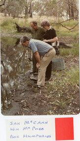
Photograph, Stawell Field Naturalists – Mammal Survey in the Grampians -- 6 Photos -- Coloured
Stawell Field Naturalists – Mammal survey Grampiansstawell -
 Federation University Historical Collection
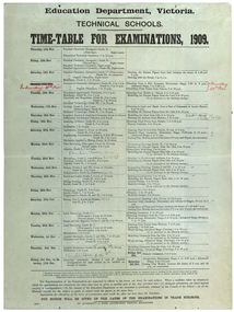
poster, J. Kemp, Education Department Victoria Technical School Timetable for Examinations, 1910, 1910
Large printed timetable for Technical School examinations in 1901. Subjects included Chemistry, Geology, Asssaying, Hydraulics, Agriculture, Engineering , Mine Surveying, Algebra, Mineralogy, petrology, Botany, Trigonometry, Euclid, Land Surveying, Steam and gas Engines, Applied Mechanics, Drawing, painting, engineering drawing, building construction, architecture, drapery, modelled design, casting clay models, composition of form and colour, Lettering, Wood Carving, historic ornament, Wood Carving. .1) Trade Subjects .2) Other subjects, including artexaminations, technical schools, trades, art, technical art school, timetable, clay modelling, ceramics -
 Bendigo Historical Society Inc.
Map - HUSTLER'S REEF MINE - EAST & WEST CROSS-CUTS, NORTH & SOUTH OF SHAFT
East & West Cross-cuts, North & South of Shaft, Hustler's Reef Mine Bulletin No 33, Plate No XIX. Map shows main shaft and smaller drawing of section with different stone encountered. Also gives location in relation to the shaft, e. g. 225'E & 150'S of Shaft. Reference diagram to show the different stone and features encountered. Geological Survey of Victoria emblem. Signed by H A Whitelaw, Underground Survey Office Bendigo, September 1913. This item has not been scanned or photographed.mining, parish map, hustler's reef mine, east & west cross-cuts north & south of shaft, geological survey of victoria, h a whitelaw, underground survey office bendigo -
 Bendigo Historical Society Inc.
Map - FORTUNA HUSTLER'S MINE - PLAN OF FORTUNA HUSTLER'S MINE
Map and plan of the Fortuna Hustler's Mine on the Hustler's Line of Reefs. Bulletin No 33, Plate No 1. Plan gives depth of the different levels. Bendigo Railway Station is on the map and also a number of the streets. Carpenter Street is called Cemetery Road. Also on the Hustler's Line of Reef is the Summer Hill Shaft. Shown is the Hustler's Royal Reserve No 2 Lease. Map has the Geological Survey of Victoria crest. It is signed by H Whit ?an Underground Survey Office Bendigo, September 1913. This item has not been scanned or photographed.map, fortuna hustler's mine, plan of fortuna hustler's mine, hustler's royal reserve no 2 lease, summer hill shaft, hustler's line of reef -
Melbourne Tram Museum
Newspaper, The Age, "Tram cram? Loaded question", 3/10/2019 12:00:00 AM
"Tram cram? Loaded question" by Zach Hope Public transport advocates claim state government report is misleading due to poor choice of survey selection points. Trams are surveyed at the edge of the CBD and do not consider overcrowding due to the free tram zone. Article has photo of crowded E-class tram and a cartoon. Department of Transport website accessed 2/11/2019 for report. See: https://transport.vic.gov.au/-/media/tfv-documents/tram-passenger-load-may-2019-pdf.pdf?la=en&hash=B739751488A495DC74B732E8C71FAF4E.trams, tramways, tram routes, e class, reports, passengers, tram 2061 -
Bendigo Historical Society Inc.
Document - MARKS COLLECTION: PARISH PLAN OF WHITE HILLS
Sepia coloured map showing allotments in Parish of Sandhurst (White Hills) Written on LH side of map town and Suburban Lots White Hills Parish of Sandhurst. Scale is shown in chains. Surveyed by Horage Walker. Photo lithographed at the Department of Lands & Survey, Melbourne by J.Noone, Price 1/-. 6th. January 1865. Map shows Race Course Reserve at top of sheet, Municipal boundary is marked on LH side. Comments re vegetation throughout map. For example, poor soil timbered with Box scrub.bendigo, planning, white hills parish map -
 Bendigo Historical Society Inc.
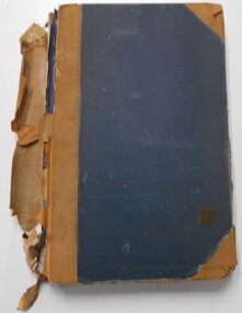
Document - LANDS OFFICE, CROWN LOTS SURVEYED AND SOLD IN THE SANDHURST DISTRICT 1857 - 1905, 1857 - 1914
Document: blue hard cover journal with buff spine and corners. (spine in poor condition, frayed and pieces missing) Contains details of crown lands surveyed and sold in Sandhurst district. LH page: town, suburban or country lands. RH page: auction, selection, price per acre, price overall and purchaser. Indexed by parish inside front cover. On spine ' Index book' ' Lands and Survey' '07' written on spine under damaged spine cover. Dated from 26/6/1857 to 24 February 1914Lands Officeland sales, lands office, land surveyed, land sold, bendigo, sandhurst -
 Bendigo Historical Society Inc.
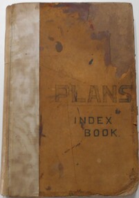
Document - LANDS OFFICE, - INDEX TO CROWN LANDS SURVEYED AND SOLD IN THE DISTRICT OF SANDHURST
Document: Buff hard cover book, with fawn coloured binding on spine (later addition to mend spine?) On front cover drawn in black pen ' PLANS' and 'Index Book' On spine written in black ink ' plans index book'. Contains index of parishes in front of journal with 470 pages indexed to parishes. Double page entries: LH side page: town, suburban or country lands, total lands surveyed. Date of survey. RH page: allotment, section, particulars, no. page. Entries are not dated.Lands Officeland sales, lands office, land surveyed , land sold, bendigo, sandhurst -
 Bayside Gallery - Bayside City Council Art & Heritage Collection
Photograph, Department of Crown Lands and Survey, Victoria, Melbourne Project: Brighton and Elwood, 1976
The Department of Crown Lands and Survey (1857-1983) was responsible for the administration of survey and mapping and the sale, occupation and management of crown land throughout its existence. This aerial photograph shows parts of Brighton and Elwood and was taken on 1 December 1976brighton, elwood, department of crown lands and survey, aerial photograph, elsternwick park, point ormond, north road, ormond esplanade, st kilda street, glen huntly road, bayside, port phillip bay, map, cartographic material, melbourne project 1976 -
 Bayside Gallery - Bayside City Council Art & Heritage Collection
Photograph, Department of Crown Lands and Survey, Victoria, Melbourne Project: Brighton and Hampton, 1976
The Department of Crown Lands and Survey (1857-1983) was responsible for the administration of survey and mapping and the sale, occupation and management of crown land throughout its existence. This aerial photograph shows parts of Brighton and Hampton and was taken on 1 December 1976. brighton, department of crown lands and survey, aerial photograph, bayside, port phillip bay, map, cartographic material, melbourne project 1976, brighton yacht club, middle brighton baths, hampton, green point, brighton beach, south road, the esplanade, hampton street -
 Bendigo Military Museum
Administrative record - American - Australian Officer Exchange - End of Tour Report ASR 1995, Major A Cordova US Army Corps of Engineers, Major Andrew J Cordova US Army Corps of Engineers, 10. 05.1995
USA - Australian Officer Exchange End of Tour Report 1995. Produced by Major Andrew J Cordova, US Army Corps of EngineersA4 Report with light cardboard cover. Cover has RASvy Corps badge and title "Army Survey Regiment" 3 pages - actual report plus cover page, letter from US Embassy and contents pageroyal australian survey corps, rasvy, fortuna, army survey regiment, army svy regt, asr -
Glenelg Shire Council Cultural Collection
Certificate - Certificate - Certificate of Survey - "Trewalla", Jun-68
Retrieved from the files of the former MCD Manager at Portland Visitor Information CentreFoolscap size certificate of Survey from 'Trewalla" No 170, dated 28 June 1968 entitling the "Trewalla" to operate within the limits of the Port of Portland until 29/5/1969. Embossed with the seal of the Marine Board of Victoria. -
 Ringwood and District Historical Society
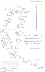
Document - Copy of Lands Department Field Notes - Parish of Ringwood, Victoria, Field Notes 55114 Survey of Allotment by J.D. Sherwood in 1955
5618b Foolscap size photocopy of survey map with handwritten notations. References include Railway (Reserve), Education Department, A-B Datum 117degrees20', Bedford Road, Certification by J.D. Sherwood Licensed Surveyor 23/11/1955. -
Bendigo Historical Society Inc.
Map - BAMAWM : COUNTY OF BENDIGO, 19-8-24
Map. Bamawm, County of Bendigo, Turrumberry, Pannoobamawm, Diggorra, Ballendella, Millewa. Photo-Lithographed at the Department of Lands and Survey, Melbourne by W.J. Butson, 19-8-24, Price 1/-. (number 50 in map cupboard 1)W.J. Butsonmap, bendigo, bamawm -
Bendigo Historical Society Inc.
Document - MAP INDEX SHEETS, No dates on item
Map index sheets for Military survey Inch to the Mile scale maps.Covering Victoria , Tasmania, Northern Territory,Queensland and New South Wales. There are Four sheets numbered 9156 a, b , c and d. These are photocopied sheets, NOT originalsdocument, map index sheets, inch to the mile index sheets -
 Villa Alba Museum
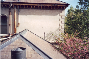
Photograph - Slate roof at the rear section of Villa Alba, c.1987
Built for William and Anna-Maria Greenlaw in the early 1880s, and with interiors decorated by the Paterson Bros, Villa Alba remained in private ownership until 1949. From 1950, the house was owned by a number of institutions. By 1984, the Villa Alba Preservation Society had been formed, and three years later, the Mount Royal Hospital granted a 25-year lease to Kew Council. In 2004, the title to Villa Alba was passed by the Victorian Government to The Villa Alba Museum Incorporated. The Museum, at 44 Walmer Street, Kew, is now a cultural institution committed to the collection, study and display of 19th century interior decorative finishes, and the components of 19th and 20th century interior decoration.This is one of a number of historically and aesthetically significant photos of the interiors and exterior of Villa Alba when it was still owned by the Mount Royal Hospital, showing twentieth century accretions and deterioration of the historic fabric of the building. This was a benchmark survey against which future conservation and restoration activities can be measured.In December 1987, Mockridge Stahle & Mitchell Pty Ltd Architects prepared ‘Villa Alba Survey: A Report on the fabric for Mount Royal Hospital’ of which this photograph is a part. Photo of slate roofs on the rear section of Villa Albavilla alba museum, conservation photographs, victorian architecture, slate roofs -
Whitehorse Historical Society Inc.
Map, Burwood Road, Box Hill City, 15/02/1952 12:00:00 AM
Detailed map of subdivision along the north side of Burwood Road, Box Hill between Station Street and Middleborough Road.Detailed map of subdivision along the north side of Burwood Road, Box Hill between Station Street and Middleborough Road. Shows many block owners, types of buildings, nature of fencing. Marked as 'Survey Plan No 5440'.Detailed map of subdivision along the north side of Burwood Road, Box Hill between Station Street and Middleborough Road. maps, burwood road, burwood, andrews street, greenwood street, tennyson street, middleborough road, station street -
Lakes Entrance Regional Historical Society (operating as Lakes Entrance History Centre & Museum)
Photograph, 1860 c
See photocopied notes from Gippsland Heritage Journal No 13 pgs 7 and 8 See Gippsland in Focus re photographerSepia toned photograph showing Geodetic camp of the survey team working on the Geodetic line marking the border between N S W and Victoria from Cape Howe to nearest source of the Murrary River Gippsland Victoriapublic works, road construction and maintenance -
 University of Melbourne, Burnley Campus Archives
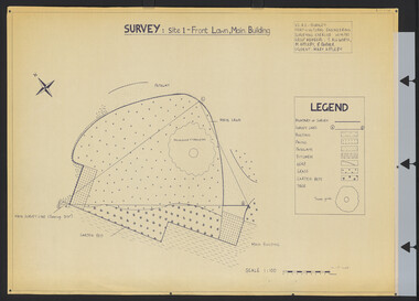
Plan, Survey: Site 1 - Front Lawn, Main Building, 1985
Plan of Front Lawn area with legend. V.C.A.H - Burnley Horticultural Engineering Surveying Exercise dated 10.09.1985. Group Members: T. Allworth, M. Appleby, B Barker (Student: Mary Appleby). Scale 1:100.vcah, lawns -
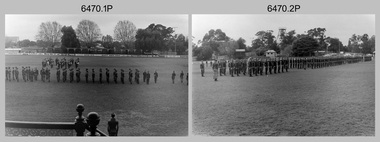 Bendigo Military Museum
Photograph - Army Survey Regiment Freedom of Entry Parade Rehearsal, Bendigo CBD, 1985
This set of 30 black and white photographs were taken at the Army Survey Regiment’s parade rehearsal held at the Queen Elizabeth Oval, Bendigo on the 27th of June 1985. The rehearsal was for the Freedom of Entry parade held 1-2 weeks later in 1985. The exact date for the Freedom of Entry parade is not known. The Freedom of Entry to the City of Bendigo was an honour first conferred by the Bendigo City Council to the Army Survey Regiment in 1970. The Freedom of Entry parade in 1985 was the fourth time the unit exercised its right of freedom of entry. The Regiment also exercised its Freedom of Entry with anniversary parades in 1977, 1980 and 1995. Refer to items 6020.8P, 6021.25P, 6248P, 6266, 6409.2 and 6430.39P for more Army Survey Regiment Freedom of Entry photographs, documents and certificates. See item 6471.2P for photos of Lithographic Squadron taken on the same day of this parade rehearsal.This set of 30 black and white photographs of the Army Survey Regiment (Army Svy Regt) were taken on the 27th of June 1985 at a rehearsal for the Freedom of Entry parade to the City of Bendigo, held 1-2 weeks later in 1985. The photographs are on 35mm negative film and were scanned at 96 dpi. They are part of the Army Survey Regiment’s Collection. .1) - Photo, black & white, 1985. Army Svy Regt .2) - Photo, black & white, 1985. Army Svy Regt right dress drill. .3) - Photo, black & white, 1985. Officers ready to take posts. .4) - Photo, black & white, 1985. Army Svy Regt present arms. SPR Mick Arnott in foreground. .5) - Photo, black & white, 1985. Army Svy Regt presents arms. .6) - Photo, black & white, 1985. Army Svy Regt presents arms. CAPT Neil Taylor in right foreground. .7) - Photo, black & white, 1985. In readiness for arrival of guests of honour. CO LTCOL Jorge Gruszka and CPL Nick Van Dalen in left foreground. .8) - Photo, black & white, 1985. Arrival of guests of honour. CO LTCOL Jorge Gruszka leads the salute. CPL Nick Van Dalen opening the car door. .9) - Photo, black & white, 1985. CO LTCOL Jorge Gruszka formally welcomes the guests of honour, the “Lord Mayor”, acted by SGT John Zuringer. .10) - Photo, black & white, 1985. CO LTCOL Jorge Gruszka escorts “Lord Mayor” (SGT John Zuringer) from the dais to inspect the Army Svy Regt’s squadrons. .11) - Photo, black & white, 1985. Inspection of the Army Svy Regt’s squadrons. .12) - Photo, black & white, 1985. Inspection of the Army Svy Regt’s squadrons. WO1 Dave Thomson on the far right with sword. .13) - Photo, black & white, 1985. Inspection of squadrons. L to R: CAPT Neil Taylor in foreground. 2LT Kathy Ryan, CO LTCOL Jorge Gruszka, WO1 Brian Mead, Lord Mayor” (SGT John Zuringer). Front rank: 2nd right CPL TJ Wicker, SSGT Doug Gay, Centre rank: 2nd right SPR Tracy (Parker) Ash, CPL Mark Lander. .14) - Photo, black & white, 1985. Inspection of squadrons Centre rank: L to R: SPR Robin Marshall, CPL Mark Lander, remainder unidentified. CO LTCOL Jorge Gruszka, WO1 Brian Mead, Lord Mayor” (SGT John Zuringer). Rear rank: 4th right SSGT Greg Buckingham, 3rd right SSGT Ian ‘Rock’ Thistleton, 2nd right SPR Annette Godden, 1st right SSGT Graham Ragless. .15) - Photo, black & white, 1985. L to R: “Lord Mayor” (SGT John Zuringer) and WO1 Brian Mead march past the Army Band. .16) - Photo, black & white, 1985. Army Svy Regt marches past the dias. ‘Eyes right’ salute given by CO LTCOL Jorge Gruszka. .17) - Photo, black & white, 1985. Unidentified squadron marches past the dias. ‘Eyes right’ salute given by MAJ Daryl Hockings CSM. .18) - Photo, black & white, 1985. Unidentified squadron marches past the dias. ‘Eyes right’ salute given by MAJ Rob John. .19) - Photo, black & white, 1985. Lithographic squadron marches past the dias. ‘Eyes right’ salute given by MAJ Peter Raue. .20) - Photo, black & white, 1985. Unidentified squadron marches past the dias. ‘Eyes right’ salute given by by MAJ Terry Edwards. .21) - Photo, black & white, 1985. Army Svy Regt right dress drill. .22) - Photo, black & white, 1985. At attention. Front rank: L to R: SSGT Doug Gay, CPL TJ Wicker, remainder unidentified. Centre rank: L to R: SPR Robin Marshall, remainder unidentified. Rear rank: 4th right SSGT Greg Buckingham, 3rd right SSGT Ian ‘Rock’ Thistleton, 2nd right SPR Annette Godden, 1st right SSGT Graham Ragless, far right super-numery WO1 Doug Arman. .23) - Photo, black & white, 1985. At attention. Centre rank: L to R: SPR Robin Marshall, remainder unidentified. Rear rank: SSGT Graham Ragless. Super-numery rank 2nd right - WO1 Doug Arman, far right - WO2 Pat Lumsden. .24) - Photo, black & white, 1985. Army Svy Regt Advance and Review Order. .25) - Photo, black & white, 1985. Army Svy Regt presents arms. .26) - Photo, black & white, 1985. CO LTCOL Jorge Gruszka leads the Army Svy Regt’s march past the dias. .27) - Photo, black & white, 1985. Army Svy Regt marches past the dias. ‘Eyes right’ salute given by CO LTCOL Jorge Gruszka. .28) - Photo, black & white, 1985. Unidentified squadron marches past the dias. ‘Eyes right’ salute given by MAJ Rob John. .29) - Photo, black & white, 1985. Lithographic squadron marches past the dias. ‘Eyes right’ salute given by MAJ Peter Raue. .30) - Photo, black & white, 1985. Army Svy Regt completes its march past the dias. No personnel are identified. Date and occasion annotated on film negative sleeve.royal australian survey corps, rasvy, army survey regiment, army svy regt, fortuna, asr -
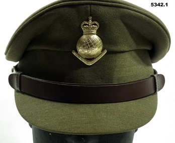 Bendigo Military Museum
Uniform - SERVICE DRESS, ARMY - Royal Australian Army Survey Corps Uniform, Commonwealth Govt Clothing Factory, 1970-1988
This is the peaked cap and uniform of 36898 Warrant Officer Thomas William Pattison, Royal Australian Survey Corps, Army Survey Regiment who served from 21 Mar 1960 until 16 Jan 1993 and died whilst in service.1. Cap - Polyester, Khaki, small peak, leather band, metal Insignia. 2. Jacket - polyester, khaki, yellow metal buttons, Insignia badges, purple lanyard, embroidered Insignia lower sleeves. 3, Shirt - polyester, short sleeves, embroidered insignia on sleeves. 4. Pants - Polyester, Khaki.Jacket - embroidered Insignia on lower sleeves - Crown.uniform, army, royal australian survey corps, rasvy, army survey regiment, army svy regt, asr -
Stawell Historical Society Inc
Book - Survey, War Related heritage in Victoria, August 2011
Survey - Overview, veterans heritage in context, survey data, Victorian war Memorials, Lost & Rescued heritage, ase studies, Community collaboration case studies, Resources for veterans heritage organizations Stawell pp 86-89 - Photos and Text.Soft Cover: Background; Sepia group of Soldiers. Colour Photo Strip: children in front of U.J. Army Nurses. War memorial Gates. etc.Dept Premier and Cabinet! Hi Val, with compliments, Cathy Nash -
 Bayside Gallery - Bayside City Council Art & Heritage Collection
Photograph, Department of Crown Lands and Survey, Victoria, Melbourne Project: Brighton, Hampton, Sandringham, 1976
The Department of Crown Lands and Survey (1857-1983) was responsible for the administration of survey and mapping and the sale, occupation and management of crown land throughout its existence. This aerial photograph shows parts of Brighton, Hampton and Sandringham and was taken on 1 December 1976brighton, department of crown lands and survey, aerial photograph, bayside, port phillip bay, map, cartographic material, hampton, sandringham, green point, sandringham yacht club, south road, beach road, hampton street, melbourne project 1976 -
 Bayside Gallery - Bayside City Council Art & Heritage Collection
Photograph, Department of Crown Lands and Survey, Victoria, Brighton, Elwood and Elsternwick, c. 1965-71
The Department of Crown Lands and Survey (1857-1983) was responsible for the administration of survey and mapping and the sale, occupation and management of crown land throughout its existence. This aerial photograph shows parts of Brighton, Elwood and Elsternwick and was taken circa 1965-71.brighton, department of crown lands and survey, aerial photograph, bayside, port phillip bay, map, cartographic material, elwood, elsternwick, elsternwick park, elwood tram depot, elwood pier, new street, glen huntly road, st kilda street, nepean highway -
 Bayside Gallery - Bayside City Council Art & Heritage Collection
Photograph, Department of Crown Lands and Survey, Victoria, Brighton, Brighton East and Bentleigh, c. 1965-71
The Department of Crown Lands and Survey (1857-1983) was responsible for the administration of survey and mapping and the sale, occupation and management of crown land throughout its existence. This aerial photograph shows parts of Brighton and Brighton East and was taken circa 1965-71.brighton, department of crown lands and survey, aerial photograph, bayside, port phillip bay, map, cartographic material, brighton east, dendy park, dendy street, centre road, nepean highway, south road, brighton golf course, golf -
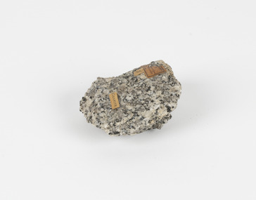 The Beechworth Burke Museum
Geological specimen - Granodiorite, Unknown
This specimen was found in Harcourt, Victoria. Harcourt is a small historic gold rush town located in a valley at the foot of Mount Alexander (741 m) in the Central Highlands of Victoria. In recent times the goldrush origins of the town have been replaced by a district known for apples, cider and wine. The Traditional owners of Harcourt are The Dja Dja Wurrung people. Granodiorite is a coarse-grained intrusive igneous rock similar to granite, but containing more plagioclase feldspar than orthoclase feldspar. Granodiorite has greater than 20% quartz by volume, and between 65% and 90% of the feldspar is plagioclase. This piece is of significance due to its provenance in Harcourt, Vic. Granodiorite is commonly produced in volcanic arcs, and in mountain buildings where it emplaces as large batholiths in mountain roots. Granodiorite is the plutonic equivalent of dacite. This specimen is part of a larger collection of geological and mineral specimens collected from around Australia (and some parts of the world) and donated to the Burke Museum between 1868-1880. A large percentage of these specimens were collected in Victoria as part of the Geological Survey of Victoria that begun in 1852 (in response to the Gold Rush) to study and map the geology of Victoria. Collecting geological specimens was an important part of mapping and understanding the scientific makeup of the earth. Many of these specimens were sent to research and collecting organisations across Australia, including the Burke Museum, to educate and encourage further study.Granodiorite is a coarse-grained intrusive igneous rock similar to granite, but containing more plagioclase feldspar than orthoclase feldspar. According to the QAPF diagram, granodiorite has a greater than 20% quartz by volume, and between 65% and 90% of the feldspar is plagioclase.GRANDIORITE. / Locality: / Harcourt, Victoria / Other label: Geological survey / R S / Loc Harcourt quarries [?] Alexander / 1/4 Sheet. | 4 | Granite /granodiorite, granite, burke museum, harcourt, coarse-grained, igneous, plagioclase feldspar, orthoclase feldspar, quartz, mount alexander, the dja dja wurrung people, the traditional owners, central highlands of victoria, gold rush -
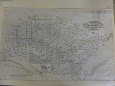 Warrnambool and District Historical Society Inc.
Map, Warrnambool 1859, Late 20th century (copy)
This is a copy of Bromfield’s 1856 map of Warrnambool and district. James Astley Bromfield was a pioneer settler in Warrnambool. He established a chemist’s shop in 1854, initially situated in Timor Street. He moved his shop to Liebig Street with a new building erected in 1875. Bromfield was a prominent resident of Warrnambool (Shire Councillor, Fire Brigade member, Cricket Club member, associated with horse racing etc). He was interested in preserving the history of Warrnambool and this map he produced in 1856 was an example of this interest.This is a copy only but this 1856 map is of prime importance as it contains the names of the original landowners of land in north Warrnambool and the surrounding district. It is a frequently-used resource by historians.This is a copy of a map of Warrnambool and its agricultural district published by James Astley Bromfield in 1856. The map is mounted on cardboard and has black printing on a white background. ‘Map of Warrnambool and its Agricultural District according to the Government Survey’s published by Astley Bromfield, Medical Hall, Warrnambool 1856, James Ferguson, Lithr., Melbne.’bromfield’s 1856, map, warrnambool and district -
 Warrnambool and District Historical Society Inc.
Documents, Swintons Paper att 18/53 Merri St. Contract. Map. Notes, 1959
These documents relate to the sale of land in Merri Street Warrnambool in 1959 by Swintons Pty Ltd of Warrnambool. The buyer of the land was George O’Grady, a Warrnambool baker. The land sold for £4000 and there was a shed on the land (called the ‘Office’) which George O’Grady indicated he wished to be included in the sale. William and Ann Swinton migrated to Australia in 1854 and for a decade William Swinton worked as a builder and carpenter in the Warrnambool area, erecting many buildings, including the Wangoom Presbyterian Church. In 1865 he opened a store in Timor Street Warrnambool, selling groceries, hardware, china and glassware. By 1888 the business was known as William Swinton and Sons. Branch stores were opened in Wangoom, Cudgee, Nullawarre, South Warrnambool and West Warrnambool. After William Swinton died his son Robert became the first managing director of Swintons Pty Ltd. In 1934 the business split with George Swinton and Sons selling clothing, furnishings and glassware and Swintons Pty Ltd selling seeds, produce and hardware. Today the Swinton family still operates a furniture and bedding shop in Timor St Warrnambool.These items are of some interest as being connected to the Warrnambool business of Swintons Pty Ltd. They will be of interest to researchers. The current Swinton business in Timor Street is the oldest family business in Warrnambool and, with the name Swinton associated with businesses in Timor Street Warrnambool for 152 years it is amongst the oldest family businesses in Australia.The items here relate to the sale of land by Swintons Pty Ltd., Warrnambool. .1 These are three pages of white paper with typed material, a lawyer’s signature in blue ink, one green stamp and a sketch of the land location. .2 This is a sheet of thick paper containing a plan of the land sold. The paper has printed material and a sketch of the land with part of it coloured in pink. .3 This is a small piece of paper torn at the bottom right edge. It has handwritten material (a letter) in blue ink..2 ‘Plan of Survey of Part of Crown Allotment 18 Section 3 Township of .2 ‘Plan of Survey of Part of Crown Allotment 18 Section 3 Township of Warrnambool Parish of Wangoom County of Villiers’ .3 ‘Tuesday Dear Mr Swinton I am writing to say that I would like to have the ‘Office’ Thanking You George O’Grady’swinton family,, warrnambool -
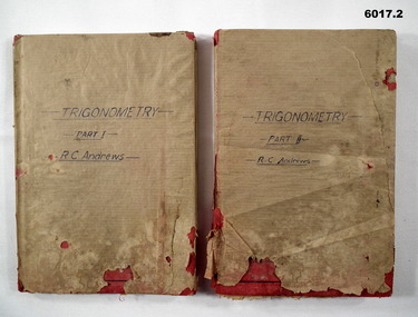 Bendigo Military Museum
Manual - Trigonometry Part 1 and Part 2, Cambridge University Press, 1948
Manuals of Trigonometry as used by the Royal Australian Survey CorpsHardcovered, Red Book, Brown Paper covered, textroyal australian survey corps, rasvy, fortuna, army survey regiment, army svy regt, asr -
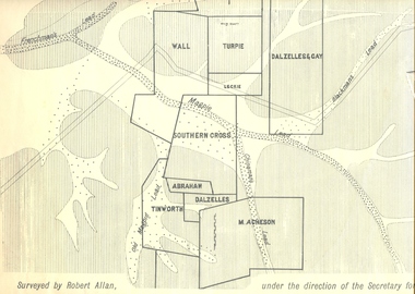 Federation University Historical Collection
Plan, Underground Survey of Mines, Ballarat East, 1885, 09/1889
Surveyed by Robert Allan under the direction of the Secretary of Mines.Rectangular plan showing placement of mines in 1889. Mines include Hick's and Gilpin's lease, Comstock, Melbourne Company, Victoria United, Speedwell Company, New Normanby, Pasha Surprise, Central Sulieman, West Llanberris, Britannia United, Victoria Unites, Clinton's, Orient Company, North Sulieman, Sulieman Extended, Pasha Surprise, Golden Fountain, Prince regent, Clark and Company, Tinworth, North Woah Hawp, Detering, R.A. Thompson, Dazelles and buchanan, Barnett, Braybrook, Ladt Cornwall, Hanthorne, Dalzelles and gay, Southern Cross, M. Acheson, Cricket Reserveballarat east, mines, mining, underground survey, robert allan, chinese, ah chong, ah young, bakery hill, black hill, black hill lead, bakery hill lead, cricket, pennyweight hill, gravel pitts lead, golden point lead, navy jack's lead, mopoke lead, eureka lead, association lead, warrenheip lead, cgt, plans