Showing 2478 items matching " township"
-
 Bendigo Military Museum
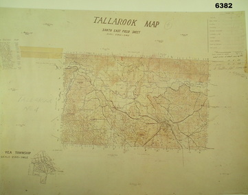
Map - Australian Topographical Survey TALLAROOK SE Sheet, 1 inch:1 Mile, NW portion Plane Table Field sheet 1923, Australian Survey Corps, 1923
This is a coloured reproduction print of an original Plane Table compilation map sheet of Tallarook area 1inch to 1 Mile scale compiled by Sgt Jack Cullen Australian Survey Corps 12 November 1923 and signed by Capt J Lynch. Capt Lynch and Sgt Cullen were both foundation members of the Australian Survey Corps. Of particular interest is the fact that this is a heighted compilation with contouring (required for Military use) as many early maps were purely planimetric. The reverse side of this print is a copy of the Nagambie plane table South West field sheet.Reprinted coloured Image of Australian Topographical Survey TALLAROOK SE field Sheet,1 inch:1 Mile, hand drawn contoured Plane Table Field sheet. Signed by Sgt J Cullen Australian Survey Corps November1923. An enlargement of YEA Township 2 Inches to 1 Mile Scale.royal australian survey corps, rasvy, fortuna, army survey regiment, army svy regt, asr -
 Bendigo Historical Society Inc.
Map - ELLESMERE, COUNTY BENDIGO, 17-3-16
Map, Ellesmere, County Bendigo, Goornong, Bagshot, Muskerry, Wellsford, Axedale, Township of Fosterville.Campaspe River, Bendigo Creek, Railway Line.Photographed at the Dept. of Lands and Survey, Melbourne by W.J.Butson 17-3-16.Price 1/-. By authority Albert J.Mullett, Government Printer, Melbourne. ( number 38 in Map Cupboard 1)Albert J.Mullett, Govt. Printer, Melbourne.map, bendigo, ellesmere -
Bendigo Historical Society Inc.
Map - RUNNYMEDE : COUNTY OF BENDIGO, 8-12-13
Map. County of Bendigo, County of Rodney, Burnewang, Elmore, Nolan, Campaspe, Colbinabbin, Burramboot, Corop, Township of Runnymede, Campaspe River, Mount Pleasant Creek. Photo-Lithographed at the Department of Lands and Survey, Melbourne by W.J. Butson.8-12-13. Price 1/-. (number 107 in map cupboard 1)W.J. Butsonmap, bendigo, runnymede -
Bendigo Historical Society Inc.
Map - TOOLLEEN : COUNTY OF BENDIGO, 25-5-26
Map. Toolleen, County of Bendigo, County of Rodney, Campaspe, Colbinabbin, Cornella, Crosbie, Muskerry, Mount Pleasant Creek, Township of Toolleen. By authority H.J. Green, Govt. Printer. Photo-Lithographed at the Department of Lands and Survey, Melbourne by W.J. Butson, 25-5-26. (number 106 in map cupboard 1)H.J. Green, Govt. Printermap, bendigo, toolleen -
Bendigo Historical Society Inc.
Map - TOOLLEEN : COUNTY OF BENDIGO, 25-5-26
Map. Toolleen, County of Bendigo, County of Rodney, Campaspe, Colbinabbin, Cornella, Crosbie, Muskerry, Mount Pleasant Creek, Township of Toolleen. By authority H.J. Green, Govt. Printer. Photo-Lithographed at the Department of Lands and Survey, Melbourne by W.J. Butson, 25-5-26. (number 105 in map cupboard 1)H.J. Green, Govt. Printer.map, bendigo, toolleen -
 Bendigo Historical Society Inc.
Document - LONG GULLY HISTORY GROUP COLLECTION: PRESS RELEASE
BHS CollectionCopy of a two page press release mentioning the placement of an information marker to acknowledge the achievement that underground mining made to Bendigo. It was felt that Long Gully was the ideal location for a marker as not only was the Long Gully township an underground mining centre it is also close to being geographically the centre of the Bendigo deep mining field.bendigo, history, long gully history group, the long gully history group - press release, the long gully history group, the cornish association, the city of greater bendigo, long gully community house -
 Bendigo Historical Society Inc.
Map - FRED COWIE COLLECTION: AERIAL MAPS OF HEATHCOTE/EPPALOCK, 28-9-1960
Map, Heathcote C2, Township of Heathcote, Melbourne Road through town branching off to Bendigo & Echuca. Aerial Survey of Victoria. Photo-map prepared by Department of Crown Lands and Survey from photographs taken in 1960. Copied photographically at the Central Plan Office.Fred Cowie,46 McIvor Rd,Bgo..Central Plan Officemap, heathcote, fred cowie -
 Warrnambool and District Historical Society Inc.
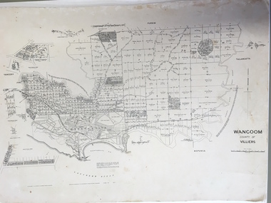
Document: Map, Map Wangoom County of Villiers, 1955
This map contains the names, acreage details and dates of the original property owners of the Parish of Wangoom (County of Villiers), excluding the township of Warrnambool. It also has details of the Crown Lands adjoining the Merri and Hopkins Rivers. This is a most important map as it has details on the original property owners. It is a most valuable research tool and is one of our most-used maps.This is a map, printed in black and white and mounted on cardboard. Where there was intensive land ownership the details have been reproduced in larger print on the margins of the map. There are scuff and dirt marks on the map but it is otherwise in good condition.‘Wangoom, County of Villiers’wangoom, warrnambool, county of villiers -
 Eltham District Historical Society Inc
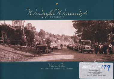
Book, Warrandyte Historical Society, Wonderful Warrandyte - A Portrait by Valerie Polley, 2014
The Warrandyte Historical Society aims to collect, preserve and present the town's history. This books draws on the archival and memorabilia resources of the Society and other sources to paint a portrait of the township, its landscape, buildings, organisations and community.Warrandyte holds a significant place in Victoria's gold mining, art and settlement history.ISBN 9780992429102warrandyte, anderson's creek -
Donald History and Natural History Group operating the Donald Court House Museum
Kerosene Can
This Kerosene can was used by Georgie Ah Ling, who operated a market garden on the edge of the township of Donald for over 70 years. It was filled from a larger Kerosene tin, and was used to fuel Kerosene lamps.Cylindrical galvanised Kerosene can with oval shaped handle with a cap over the opening, chained to a smaller handle fixed to the body.kerosene can, georgie ah ling, market garden, donald, kerosene lamps, -
 Wangaratta RSL Sub Branch
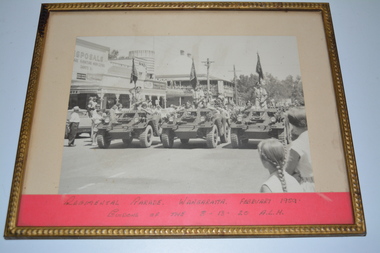
Memorabilia - Photograph, Regimental Parade, 1959
Black and white image of three armoured vehicles each with soldier escorting large guidon/flags of the 8th/13th/20th Australian Light Horse regiments on parade through township of Wangaratta in February 1959 Gold colour metal frame containing cream mount and black and white photograph depicting three armoured vehicles each with soldier holding a guidon/flag Regimental Parade Wangaratta February 1959 Guidons of the 8th/13th/20th ALH8/13 victorian mounted rifles, 1959, guidons, wangaratta -
Hume City Civic Collection
Photograph, Verna Hommsen, 30th May 1995
Verna Mommsen is the lady in the photograph, who came to Sunbury from Bright. She and her husband managed Red Rock Farm from 1942. In later years they moved to Aitken Street in Sunbury township.A non-digital sepia photograph mounted on cream paper of a lady wearing glasses. She is standing near a wooden stand, which has flowers on it.verna momkmsen, red rock farm, sunbury -
 Bendigo Historical Society Inc.
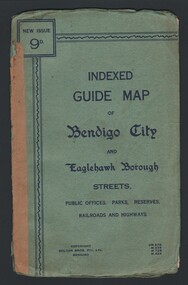
Map - INDEXED GUIDE MAP OF BENDIGO CITY & EAGLEHAWK BOROUGH, Early to mid 1920's
Map. Indexed Guide Map of Bendigo City & Eaglehawk Borough. Folded map contained within blue booklet. Booklet is light blue printed with dark blue ink. Copyright Bolton Bros. Pty. Ltd. Bendigo. Printed on front. Map shows the location of Sailors Gully, Peg Leg Gully, California Gully, Long Gully, Eaglehawk Creek, Bendigo Creek, Ironbark Creek. Shows location of Showgrounds between Park St, Baxter Street, Barnard St and Bridge Lane. Shows location of Golden Square Railway Station between Panton St and Allingham St. Shows what is now known as Creek St. Nth & Sth as Clark St Nth & Sth. Also shows Tramway Terminus along Carpenter St and Golden Square Tram Terminus on High St, Golden Square. Map has a street index and an index for Public Offices, Parks and Reserves.map, bendigo, township, indexed guide map of bendigo city and eaglehawk borough -
 Bendigo Historical Society Inc.
Map - GUIDE MAP OF BENDIGO & EAGLEHAWK, Late 1920's
Map. Guide map of Bendigo & Eaglehawk. Folded map of Bendigo & Eaglehawk with blue outer cover booklet. Map is compiled by E E Parker, Eaglehawk. Map shows tramways, bus routes and cost one shilling. Map shows Agricultural Showgrounds located between Park Street, Water Street, Barnard Street and Bridge Lane. Also shows Acclimitization Reserve located behind the Botanical Gardens at White Hills. Shows the location of Sailors Gully, Peg-Leg Gully, Jobs Gully, California Gully, Long Gully, Ironbark Gully, Golden Gully, Poverty Gully, Sheepshead Gully, Charcoal Gully, Eaglehawk Creek, Bendigo Creek and Back Creek.Contains interesting facts about Bendigo:- Area - 7,900 acres, Population - 26,000, First Council elected - 1855, Proclaimed a City - 1871. Gold Rush broke out - 1851. For first 10 years gold yield averaged 8,600 ozs. Per week. Total gold yield to 1923 - 572 tons valued at 82,000,000 pounds. Deepest mines - Victoria Quartz 4,614 ft., New Chum Railway 4,318 ft., 13 mines over 3,000ft. deep, 53 mines over 2,000 ft. deep. Sewering of City commenced 1922. All principal buildings now sewered. Map printed by Arnall & Jackson, General Printers, Stationers & Engravers, 476 Collins Street. Outer map blue cover printed in red and blue ink by J B Young, Lithographer. Map displays advertisement for Bendigo Timber Co. Outer blue cover displays advertisement for Campbell Connelly & Co. Pty. Ltd, Ironmongers, Timware Manufacturers, Plumbers, Sewerage Contractors, High and Forest Sts, Bendigo 9outside back cover) and for Hartleys ( J L Shoosmith) Bendigo, displaying Indian Motor Cycles (inside back cover).map, bendigo, township, guide map of bendigo & eaglehawk -
Bendigo Historical Society Inc.
Map - GOORNONG, 1/10/1906
Map: Town of Goornong, Parish of Goornong, County of Bendigo. Parish plan (number 269 in map cupboard 1)map, bendigo, township, goornong -
Bendigo Historical Society Inc.
Map - HARCOURT, 2/04/1917
Map: Town of Harcourt, County of Talbot. Parish plan (number 264 in map cupboard 1)map, talbot, township, harcourt -
 Clunes Museum
Photograph, BALLARAT ROAD, CLUNES, SOUTH WEST, 1865
PHOTOGRAPH SHOWS MANSE PREBYTERIAN [ST ANDREWS[ CHURCH METHODIST [WESLEY[ WITHOUT SPIRE, SUNDAY SCHOOL AND PARSONAGE MARKET, POST OFFICE SITE TOWN HALL PHOTOGRAPH OF BALLARAT ROAD [SERVICE STREET] CLUNES. PHOTOGRAPH TAKEN FROM GEORGE STREET TOWARDS SMEATON ROAD. .1 SEPIA PHOTOGRAPH MOUNTED, WITH POINTS OF INTEREST NOTED AROUND EDGE. PERIOD 1865 .2 BLACK AND WHITE PHOTO PRINT .3 SMALL BLACK AND WHITE PHOTO PRINTBALLARAT ROAD, CLUNES, SOUTH WESTphotography, photographs, township, churches -
 Lakes Entrance Historical Society
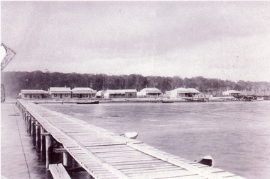
Photograph - Lakes Entrance, 1920c
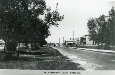
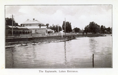
Also 10 x 15 cm sepia copy, has remnants of glue of the back, little bit fadedBlack and white photograph of Esplanade, showing Maranui Guest House, Police Station, corner of Bellevue Guest House and Club Hotel in distance. Natural vegetation of Coastal Banksia on grass verge between road and waterfront, and beside Maranui Guest House. Lakes Entrance VictoriaThe Esplanade Lakes Entrancewaterfront, township, guesthouses, police -
 Lakes Entrance Historical Society
Postcard - Lakes Entrance, 1920c
Also black and white 9 x 14 cm copy, but not Vogt, inscription The Esplanade, Lakes EntranceBlue and white postcard showing a section of the western end of Esplanade, showing lake, foreshore, Vize's Cafe, Bellevue Guest House, Police Station, Maranui Guest House and, partially hidden by trees, residential houses. Lakes Entrance VictoriaLakes Entrance The Esplanadeguesthouses, township, police, retail trade -
 Lakes Entrance Historical Society
Photograph - Barke's Store, 1900c
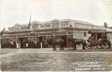
This is the before paired photograph used in the 150 year, Lakes Entrance 1858-2008 display.|The after paired photograph number is 01402.1|Also one 12 x 16 framed photograph used in room display.Black and white photograph of Barkes Store. Store was built in 1893, opposite the Post Office on Esplanade. Photo shows a large weatherboard building, hipped iron roof, imitation gables and timber frieze decorate the veranda roof. Building has many signs advertising various goods, products and services. A four-horse drawn wagon and crowd of people at front of the store, on ground-level wooden veranda floor. Lakes Entrance VictoriaLakes Entrance Cunninghame Gippsland, Victoriatransport, township, retail trade, room display -
 Lakes Entrance Historical Society
Postcard, 1928c
Black and white photograph of Whiters Park, showing residence and office, gardens, tennis court, early model car by the petrol bowser, electric lights on tall poles. Opposite park entry is Aults Motor Engineer, scattered cottages. In distance is Cunninghame Arm, sand hummocks and ocean. Lakes Entrance Victoriaresort, township, transport, recreation -
 Lakes Entrance Historical Society
Postcard - Lakes Entrance, 1930c
Two other copies black and white 15.5 x 23 cmBlack and white postcard, taken from across the lake, of the Club Hotel and Stables, Dave Coate's residence, Mitchelson's double story house, Coate Bros Garage (later Crawford's), Robin Hood Inn and Broome's Federal Guest House, launch and houseboat moored in the lake. Lakes Entrance VictoriaLakes Entrance from the South Sidewaterfront, boats and boating, township, retail trade -
 Lakes Entrance Historical Society
Photograph - Street Scene, 1895c
Also copy 13.5 x 20 cmBlack and white photograph of the western view of the Esplanade, also known as Cunninghame, showing early business houses, and residences. Included is Mrs Gleeson's Boarding House, William Barke's store, Heyfield Coffee Palace, butcher shop. Three small jetties, one substantial jetty and two small boats beside lake. Lakes Entrance Victoriatownship, waterfront, retail trade, jetties -
 Lakes Entrance Historical Society
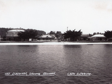
Photograph - Glenara Guest House, Bulmer H D, 1935c
Copy black and white photograph of a section of Esplanade, viewed from the front lake. Buildings in view are the Prince Regent Theatre including the chemist shop, the original Glenara Guest House, and shops. Lakes Entrance VictoriaThe Esplanade showing Glenara, Lakes Entrancecinema, guesthouses, township, waterfront -
 Lakes Entrance Historical Society
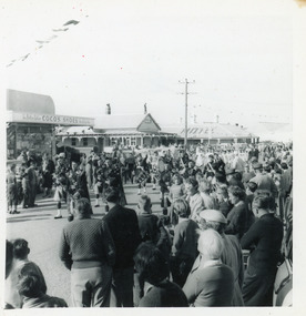
Photograph, Fish, Marie, 1961c
Black and white photograph of the crowd on Esplanade, watching the street procession during the visit of the Governor General Lord and Lady Dunrossil. In the background Coco's Shoe Shop and Victoria House Motel. Lakes Entrance Victoriatownship, celebrations, retail trade, motels -
 Lakes Entrance Historical Society
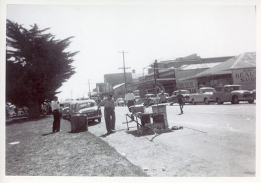
Photograph, 1950c
Black and white photograph of a section of Esplanade. In view are the Maranui Motel, Catalina Cafe, Bulmers Gift Shop, Bill's hairdresser. Cypress trees on grassy verge on south side of highway. 44 gallon drum, trestle table and frame for shelter on edge of road seemingly in preparation for, or remaining after a street celebration. Lakes Entrance Victoriamemorials, township, celebrations, retail trade -
 Lakes Entrance Historical Society
Photograph, 1960c
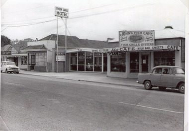
There was Billiard parlour down that end of town in the early 50’s. in Carstairs Ave. Rosmary Kavadis father (John Kostantinidis) owned it and it held 2 big tables 12 x 6 and the main games played were snooker and billiards. On the corner of Cairstairs Ave opposite Robin Hood Inn. The cafe Duckin, Mr and Mrs Kostantinidis bought it and on the side of that cafe down a verandah was the Billiard Room. It was very popular and a lot of the locals would play there. Rosemary was about 5 - 7 years old and had to stand on a fish box to play. It was very popular and next door was the Bamboo Coffee Shop run by Mr and Mrs Varney The'Duckin' became Peels bait shop Dot and Con Coucoulas took over the Bamboo and turned it into a motel not sure on the year and then bought the Duckin and demolished it. It was after Tween Lakes was built in 1959, as that was the first motel in townThe first 20 units and restaurant were built in 1959 with firsts guests on Dec. 22nd.1959. The units 21-27 plus the front residence and office were built in 1962.Black and white photographic copy of a short section of the Esplanade, which shows a fish shop, Bamboo Cafe, Tween Lakes Motel, and Johns Fish Shop. A 1950c Holden sedan parked in front of Fish Cafe, and Holden wagon in front of Bamboo Motel. Lakes Entrance Victoriatownship, motels, transport, restaurant -
Lakes Entrance Historical Society
Book, Gippsland Heritage Journal - issue 20, 1997
No 21 of a series contains articles on building materials around the Gippsland Lakes, Brown Coal Mine School, Rancby Church, Yarrams Regents Theatre, town of Moe, Mary Fullerton, Kingsford-Smith, Wonthaggi Leek Club. Also many photographs and lithograph obuilding industry, schools, religion, township -
Lakes Entrance Historical Society
Book, Fairweather Keith McD, Time to Remember, 1975
A history of gold mining on the Tambo River Gippsland Victoria including Cassilis Tongio West Long gully Brookville Stirling includes photographs and indexmines and mining, settlers, township, schools -
Lakes Entrance Historical Society
Book, Squires Debra, When I was a boy at Sunnyside, 1988
Childhood memories of James Alexander Ross who spent his childhood and youth at Sunnyside in Gippsland Alps North of OmeoThe memories of Jim Ross with additional research by Debra Squiresmines and mining, township, schools, cemeteries