Showing 3443 items matching "distance"
-
 Sunbury Family History and Heritage Society Inc.
Photograph, c1989
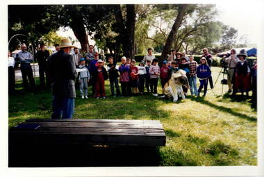
The children from Bulla Primary School were taken on an excursion to Gellibrand hill Park which is a short distance from the School. The emphasis on the day's excursion was to identify the native fauna in the park as well as the vegetation.The property was originally settled by the Greene family in 1843. In 1980 the State Government purchased the property and it is now one of the state's parks where the natural vegetation has gradually been restored on the property. A non-digital coloured photograph of a group of adults and children listening to a man who is standing in front of a low seat and talking to them. There are buildings visible in the background. gellibrand hill, bulla primary school, school excursions -
 Melbourne Tram Museum
Postcard, "Collins Street Melbourne", c1929
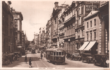
Photo looking east in Collins St from Elizabeth St with W2 class tram 284 (Spencer St) and another W2 in the distance. The tram is yet to be fitted with a route number box. The tram was the first to be converted from a W class to a W2 class (8/1928) and was fitted with route number boxes in April 1930. In the background is the Sands McDougal city office and a sign advertising Reuter's Office.Yields information about Collins St c1929.Postcard - printed, unused, with Ken Magor stamp on the rear.trams, tramways, w2 class, tram 284, collins st -
 Bendigo Military Museum
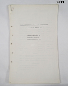
Administrative record - The Airborne Profile Recorder (APR) Ballarat Test Area, Captain EP Constantine RASvy, Circa 1962
The Airborne profile Recorder (APR) is a precise airborne radar altimeter designed to provide a continuous record of terrain clearance, (the distance between the aircraft and the ground surface). This document was condensed from a report by Captain E P Constantine RASvy Corps to test the viability of using APR for acquiring height information for mapping purposes. This document was on forwarded to the ExFortuna Survey Assoc by 4 Fd Svy Sqn in Aug 2025.21 x pages of typed text and diagrams on letter sized paper, stapled top left corner. Three and four hole punched.royal australian survey corps, rasvy, fortuna, army survey regiment, army svy regt, asr -
 Melbourne Tram Museum
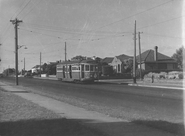
Photograph - L 102 Hawthorn Rd, East Brighton, Jim Seletto, January 1960
The photograph shows L class tram No. 102 with the destination City via Williams St route 65 in Hawthorn Rd, East Brighton. The tram is in the mid-distance and the road, span poles, street lights, residental houses with front fences are also included. Daylight with long shadows. The print is under exposed with several scratches in the centre requiring digital enhancement. Photo by Jim Seletto January 1960Shows 40 year old L class in revenue service as evidence of the MMTB's shortage of newer rolling stock.Black and white photgraph with photographer's notes on rearIn biro on rear: 'L 102 Hawthorn Rd East Brighton Jan 60 D X Print JSE7 J Seletto Phototrams, east brighton, hawthorn rd, tram 102, l class, span poles, tramways, route 65 -
![The Old Crossing-Place at Fernshawe / [by] Nicholas Caire, circa 1876](/media/collectors/550653872162f11fb04854aa/items/577b49a5d0cdd10948c74db4/item-media/577b4a0bd0cdd10948c78ebb/item-fit-380x285.jpg) Kew Historical Society Inc
Kew Historical Society IncPhotograph, Anglo-Australasian Photographic Company, The Old Crossing-Place at Fernshawe, c. 1876
Nicholas Caire was born on Guernsey in the Channel Islands in 1837. He arrived in Adelaide with his parents in about 1860. In 1867, following photographic journeys in Gippsland, he opened a studio in Adelaide. From 1870 to 1876 he lived and worked in Talbot in Central Victoria. In 1876 he purchased T. F. Chuck's studios in the Royal Arcade Melbourne. In 1885, following the introduction of dry plate photography, he began a series of landscape series, which were commercially successful. As a photographer, he travelled extensively through Victoria, photographing places few of his contemporaries had previously seen. He died in 1918. Reference: Jack Cato, 'Caire, Nicholas John (1837–1918)', Australian Dictionary of Biography.An original, rare photograph from the series 'Views of Victoria: General Series' by the photographer, Nicholas Caire (1837-1918). The series of 60 photographs that comprise the series was issued c. 1876 and reinforced a neo-Romantic view of the Australian landscape to which a growing nationalist movement would respond. Nicholas Caire was active as a photographer in Australia from 1858 until his death in 1918. His vision of the Australian bush and pioneer life had a counterpart in the works of Henry Lawson and other nationalist poets, authors and painters.Albumen silver photograph mounted on boardInscription on reverse: ‘In the distance among the foliage can be seen the New Bridge across the River Watt. Previous to its erection, the only means of crossing over to the township was across the fallen trees, which are of prodigious dimensions. The River, as may be seen, is very rapid, and, though shallow, it contains a great quantity of fish of a somewhat moderate size.’nicholas caire (1837-1918), landscape photography -
![View of the township of Golden Square / [by] Nicholas Caire, circa 1876](/media/collectors/550653872162f11fb04854aa/items/578340aed0cdd1176c6899f4/item-media/5783411dd0cdd1176c68c568/item-fit-380x285.jpg) Kew Historical Society Inc
Kew Historical Society IncPhotograph, Anglo-Australasian Photographic Company, View of the township of Golden Square, c. 1876
Nicholas Caire was born on Guernsey in the Channel Islands in 1837. He arrived in Adelaide with his parents in about 1860. In 1867, following photographic journeys in Gippsland, he opened a studio in Adelaide. From 1870 to 1876 he lived and worked in Talbot in Central Victoria. In 1876 he purchased T. F. Chuck's studios in the Royal Arcade Melbourne. In 1885, following the introduction of dry plate photography, he began a series of landscape series, which were commercially successful. As a photographer, he travelled extensively through Victoria, photographing places few of his contemporaries had previously seen. He died in 1918. Reference: Jack Cato, 'Caire, Nicholas John (1837–1918)', Australian Dictionary of Biography.An original, rare photograph from the series 'Views of Victoria: General Series' by the photographer, Nicholas Caire (1837-1918). The 60 photographs that comprise the series were issued c. 1876 and reinforced a neo-Romantic view of the Australian landscape to which a growing nationalist movement would respond. Nicholas Caire was active as a photographer in Australia from 1858 until his death in 1918. His vision of the Australian bush and pioneer life had a counterpart in the works of Henry Lawson and other nationalist poets, authors and painters.‘View of the township of Golden Square’ : Views of Victoria (General Series) No.57 : Albumen silver photograph | Photo on card with Title and Description on reverse | Mounted 24 x 30 cm; Photo 12 x 17 cm.On Reverse: ‘This Township is situated in the Bendigo district, on the road to Castlemaine, and although it is of little importance as a business town, is nevertheless of large importance in consequence of the great number of Quartz Reefs it contains. Almost every house is undermined, and large fortunes have been made by the proprietors. The Church in the distance is that of the Wesleyan body. It was in this township that gold was first discovered in the district of Bendigo.’nicholas caire (1837-1918), golden square (vic), bendigo (vic), gold mining, landscape photography - victoria -
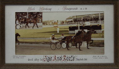 Victorian Harness Racing Heritage Collection at Lord's Raceway Bendigo
Photograph - Framed photo finish, Jigs And Reels, 14 January 1978
Jigs And Reels won the Kick Handicap at Melbourne Showgrounds on the 14 January 1978, followed by Quick Whip and Kazibob. Jigs And Reels owned by Mr G Harrison, was trained and driven by K Allen. Jigs And Reels raced from 1975 (3yo) through to 1979 then went to US and raced until 1985 (13yo). Career: 29 wins 22 seconds 20 thirds 216 starts.Two colour photographs, one small one large in a brown frame. At the top: Kick Handicap/ Showgrounds / 14-1-78 At the bottom: Left corner: Distance 2538 Metres / Kilo rate 1-22-4 Centre: Quick Whip 2nd /Jigs And Reels (Delvin Dancer - Canny Rose) / Kazibob 3rd Right corner: Owner Mr G Harrison / Trainer - Driver K Allenhorses, race, winner, driver, trainer, owner, melbourne, showgrounds, 1978, jigs and reels, k allen, mr g harrison, quick whip, kazibob -
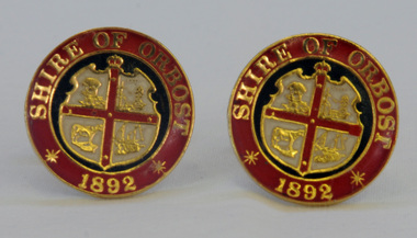 Orbost & District Historical Society
cuff links, 1992
This pair of cuff links was produced in 1992 as a memento/souvenir to commemorate the centenary of the formation of the Shire of Orbost - 1892-1992. Orbost was at first included in the Bairnsdale Shire from 1882 and was later part of the Tambo Shire. Because of travelling distances the Croajingalong Shire was created in 1892 (name changed to Orbost Shire 17.2.1893 with James Cameron as the first Shire President. In 1994 it amalgamated to become part of East Gippsland Shire Council.A pair of gold-plated and enamel cuff links embossed with the Shire of Orbost Coat of Arms and the year of inauguration.Shire of August 1892cuff-links souvenir memento orbost-shire-council -
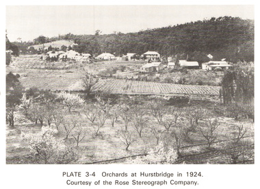 Eltham District Historical Society Inc
Work on paper (Sub-Item) - Photograph, Orchards at Hurstbridge, 1924
With the extension of the railway to Hurstbridge in 1912, large commercial orchards were able to expand. By 1914, 1,886 acres of orchards were under cultivation, with a considerable proprotion of the fruit being exported overseas. After World War One, the industry declined, mainly due to competition from other areas. This photo shows an orchard in the foreground with the township of Hurstbridge in the distance. The photo was taken in 1924, the same year that Hurstbridge was declared a township. orchard, hurstbridge, rose postcard -
 Eltham District Historical Society Inc
Photograph, View in Eltham looking south along Main road from Bridge Street, 1902
Looking south along Main Road from the south side of the intersection of Bridge Street with Main Road. Post Office (Anne Hunniford Postmistress) on left then the Commercial Bank of Australasia building. The house on the right, 'Derril,' was purchased by Walter Gahan in 1924 and was demolished in 1968 when Main Road was widened. In the distance on the left is Watson's Hotel and on the right (opposite side of the main road, Morris's Hotel Cross Ref: 0624This photo forms part of a collection of photographs gathered by the Shire of Eltham for their centenary project book,"Pioneers and Painters: 100 years of the Shire of Eltham" by Alan Marshall (1971). The collection of over 500 images is held in partnership between Eltham District Historical Society and Yarra Plenty Regional Library (Eltham Library) and is now formally known as the 'The Shire of Eltham Pioneers Photograph Collection.' It is significant in being the first community sourced collection representing the places and people of the Shire's first one hundred years.Digital image Print 14 x 24 cm 35 mm B&W negativeanne jane hunniford (1855-1928), bridge street, commercial bank of australia, derril, eltham, gahan house, main road, morris's hotel, post office, shire of eltham pioneers photograph collection, watsons hotel -
 Otway Districts Historical Society
Photograph, Colac-Beech Forest timetable, May 1911, May 1911
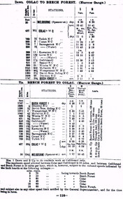
Leaving Colac the narrow gauge train goes through Tulloh. Coram, Barongarook, Kawarren, Lovat, Gellibrand, Banool, Wimba, McDevitt, Weeaproinah, Devitt Bros., and Ditchley before it reaches Beech Forest, and vice versa. The distance in miles, the height above sea level and the timing from the starting point is given. Note that Weeaproinah W NC changed its name to Dinmont when the Crowes line extension is built. Colac-Beech Forest timetable for May, 1911 showing the DOWN train from Colac to Beech Forest, and the UP train from Beech Forest to Colac plus annotations.colac; melbourne; tulloh; coram; barongarook; kawarren; lovat; gellibrand; banool; wimba; mcdevitt; weeaproinah; devitt bros.; ditchley; beech forest; railway; timetable; -
 Vision Australia
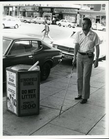
Photograph - Image, Man using white cane and sonic guide
A bearded man uses a white cane and sonic guide to help him navigate around the streets of Strathfield. The sonic guide consists of a pair of heavy black spectacles with three sensors built into the bridge of the glasses. The glasses are attached by a cable to a control box which is designed to be clipped onto the wearer's belt or clothing. The control box has two switches and a volume setting, and assists the user in determining objects in their path and their distance to them.2 B/W photographs of man using sonic guide and white cane"5156-220" and '5156-224" on back of photographsroyal blind society of nsw, white cane, orientation and mobility -
 City of Greater Bendigo - Civic Collection
Instrument - Gunter Chain, not known
Gunter's chain (also known as Gunter’s measurement) is a distance measuring device used for surveying. It was designed and introduced in 1620 by English clergyman and mathematician Edmund Gunter (1581–1626). It enabled plots of land to be accurately surveyed and plotted, for legal and commercial purposes. The provenance of this particular Gunter Chain is unknown but it is believed to be used either by the City of Bendigo / Sandhurst or the Lands Department locally when measuring and laying out plots and streets locally. A 66-foot (20.1 m) chain divided into 100 links, marked off into groups of 10 by brass rings or tags. Each link is 7.92 inches (201 mm) long. A quarter chain, or 25 links, measures 16 feet 6 inches (5.03 m) also called a a rod (or pole) measure. Ten chains measure a furlong and 80 chains measure a statute mile. city of greater bendigo surveying -
 Royal Brighton Yacht Club
Cup, E. B. Green Trophy (Cup)
E. B. Green Trophy (Cup) Donor: Deed of Gift: E. B. Green was one of the original members of the Brighton Sailing Club and in 1886/87 owned the yacht Iris. The trophy is awarded to the winner of a combined division race on IRC handicap. The race is a mid-distance race and sailed on the same day as the Top Hat Trophy on PHD handicap. First Winner: White Tie, D. R. Buxton 1966/67 green, irc, combined division -
 Eltham District Historical Society Inc
Photograph, Emily Gladys Withers in Bill & Mervyn's trench at Southernwood, Eltham, 1916
Eldest daughter of Walter and Fanyy Withers, Emily Gladys in the fortified trench constructed by her younger brother Charles Withers (aka Bill) and his good friend from school, Mervyn Britain at the Withers family home, Southernwood, Eltham. The view is looking to the east with Main Road and associated buildings near ridge in distance. [Charles son, John Withers explained that his father and friend liked to play war games.]On back of photo: "Bill & Mervyn's trench 1916 or 1917" Many items in this collection have suffered from significant water damage and black mouldjohn withers collection, eltham, 1916, southernwood, trenches, charles meynell pitt withers, mervyn britain, emily gladys withers -
 Bendigo Military Museum
Photograph - Royal Australian Survey Corps Surveyors in the Field – PNG, 1962
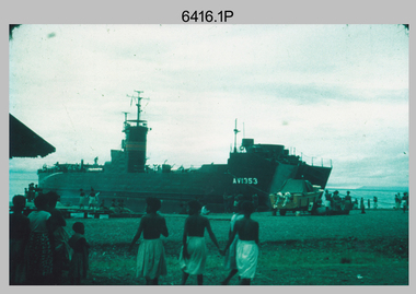
This is a set of four photographs of surveyors and support staff in the field undertaking duties in Dogera, Milne Bay Province and Kerema, Gulf Province of PNG in 1962. The surveyors were employed in the establishment of mapping and geodetic control. In this era surveyors used theodolites to observe horizontal and vertical angles and tellurometers to measure base line distances between survey stations. From 1957 helicopter transport of survey parties revolutionised transport in remote areas.This is a set of four photographs of surveyors and support staff in the field undertaking duties in PNG in 1962. The photographs were printed on photographic paper and are part of the Army Survey Regiment’s Collection. The photographs were scanned at 300 dpi. .1) - Photo, colour, 1962. Unloading survey operation stores from a Landing Ship Medium (LSM) at Dogera, Milne Bay Province, PNG. .2) & .3) - Photo, colour, 1962. Hired civilian helicopter Bell 47G-2 helicopters operating at at Dogera, Milne Bay Province, PNG. .4) - Photo, colour, 1962. Survey party at survey station located near Kerema, Gulf Province southern PNG. L to R: Dave Owens, Keith Broadbent, with local villagers in background..1P to .4P annotated on back – personnel names, the year and the location. royal australian survey corps, rasvy, army survey regiment, asr, army svy regt, fortuna, surveying -
 Bendigo Military Museum
Administrative record - Trilateration with the Tellurometer - GRL Rimington 1958, Department of National Development , ACT, 26 May 1958
trilateration with the tellurometer by GRL Rimington L.S MIS (Aust) Chief Topographic Surveyor, Department of National Development, Australia. This paper was delivered to the Institute of Surveyors Conference, Brisbane 26 May 1958. This paper is a summary of Electronic distance measurements carried out in 1957 in Central Australia by officers of the division of National Mapping, Department of National Development. Trilateration is a surveying Technique that uses measurements of the sides of triangles to determine relative position.A 11 page foolscap size stapled paper report. Two holed punched with dis-coloured pages due to age.royal australian survey corps, rasvy, fortuna, army survey regiment, army svy regt, asr, division of national mapping, surveying -
 Frankston RSL Sub Branch
Computer, Navigation
Aerial Dead Reckoning Computer in leather pouch. This device was used as a navigational aid by aircraft pilots and crew. W&G Aerial Dead Reckoning Computer R.A.A.F. Mk 1 Made in Australia by White & Gillespie Front Scale: Distance Naut Miles, True Air Speed (Time Min, Hrs, Density Altitude, Air Temp ) Back Scale: Wind Correction Angle( True Heading ) The leather pouch has the following printed on the outside "W&G Aerial Dead Reckoning Computer R.A.A.F. Mk 1" -
 Halls Gap & Grampians Historical Society
Photograph - Coloured
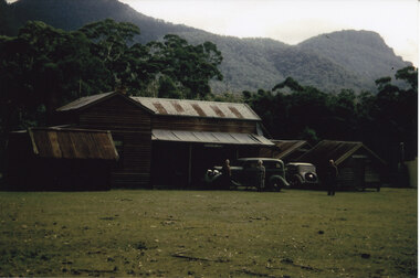
The main building and chalets were built by E. C. Mitchell of Stawell. He was given a 99 year lease by the shire to build his holiday house at the site of Borough Huts. David and May Mitchell took over ownership of the house and chalets. The women in the photo are May and Isabel Mitchell and the man is David Mitchell. The chalets were called "Flappers Roost", "Bower of Innocence" and "Last Resort". The two copies of the photo are taken from slight closer in and are not as clear and do not show the entire third chalet.The photo shows a collection of old buildings. Two women are standing in front of a car and a man is standing a short distance from them. A second car is parked between the main building and the huts. The building to the far right of the photo is painted in a cream colour and has a tin chimney. The other buildings are three small huts or chalets. Gum trees and a mountain range can be seen directly behind the buildings.buildings, houses -
 Marysville & District Historical Society
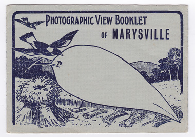
Postcard (item) - Black and white photographs, Barton Bros, Photographic View Booklet of MARYSVILLE, 1923-1963
A series of nine black and white photographs of scenic attractions taken in and around Marysville in Victoria that was published by the Barton Bros, Marysville and printed by Valentines Publishing Co as a souvenir of Marysville.A series of black and white photographs of scenic attractions taken in and around Marysville in Victoria that was published by the Barton Bros, Marysville and printed by Valentines Publishing Co as a souvenir of Marysville. Thomas Barton was one of the earliest settlers in Marysville and with 16 children and numerous descendants, the name of Barton is synonymous with Marysville. Thomas John Barton, along with his business partner, Ewen Hugh Cameron, opened a butcher/abattoirs in Marysville in 1864. This was the first shop in Marysville. They supplied meat and other items to the miners along the Woods Point road. Thomas Barton was an active community member and was a key organiser in setting up the school in Marysville in 1870. After Thomas' death in 1911, his sons Fred and Frank took over the family business and renamed it Barton Bros. To From Published by BARTON BROS., Marysvillemarysville, victoria, barton bros, acheron way (image 1), keppel's falls (image 2), cumberland falls (image 3), stevenson falls (image 4), taggerty river (image 5), mount margaret (image 6), mount gordan (image 7), nicholl's lookout (image 8), the old ford (image 9), postcard, valentine publishing co, souvenir, thomas barton, francis adam barton, frederick barton, ewen hugh cameron -
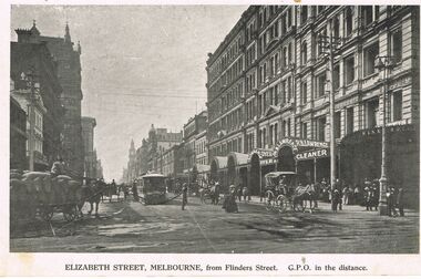 Bendigo Historical Society Inc.
Photograph - POST CARD ELIZABETH STREET MELBOURNE
post card Elizabeth street Melbourne , from Flinders Street . GPO in the distance - early 1900s ? / black and white photo on paper / picture shows R W LAWRENCE DRY CLEANER , HORSES AND CARTS AND EARLY TRAM . / back of card R B LAWRENCE , DRY CLEANER , Dry Cleaner , Ostrich Feather Dresser etc, / card addressed to Branch , 209 Mitchell St Bendigo / no stamp included .postcard, photograph, post card elizabeth street melbourne , from flinders street . gpo in the distance - early 1900s / r w lawrence dry cleaner / -
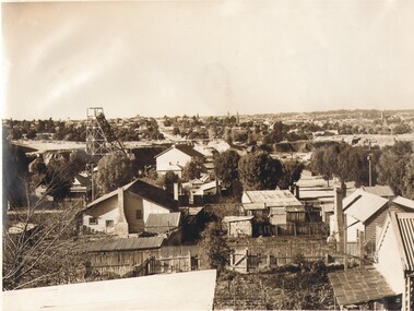 Bendigo Historical Society Inc.
Photograph - FOGGIT JONES, c1930
black and white photo : View from Foggitt Jones looking towards Bendigo 1930. Houses in foreground, poppet head left side mullock heap behind, Bendigo valley in background. (Situated in the Wade Street -Maple Street area of Golden Square. EST 1910)Sacred Heart Cathedral and St Paul's Catedral can been seen in the distance. Physical description: unmounted black and white photo.Edwin G Adamson, A>R>P>S Charters House, 165 Collins St, Melbourne, Tel. F 6330organization, business, small goods -
Port Melbourne Historical & Preservation Society
Photograph - Aerial view of J Kitchen and Sons site, Ingles Street, Port Melbourne, early 1930s, 1930s
Large Black and White aerial photograph on brown cardboard showing Kitchen and Sons buildings including the 1925 Administrative Building No 34 on Ingles st.Photograph taken looking North Easterly with Swanston and Barret Pty concrete works; Port Melbourne Football ground in foreground; Yarra River in top left hand corner; showing South Melbourne and Royal Botanic Gardens in the distance. Taken in the early 1930sindustry - manufacturing, built environment - industrial, j kitchen & sons pty ltd -
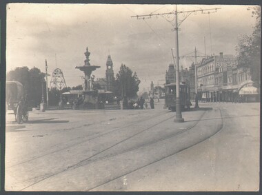 Bendigo Historical Society Inc.
Photograph - WES HARRY COLLECTION: BENDIGO LANDMARKS, 1912
Group of four photographs of Bendigo Landmarks, Taken in 1912. (a) Fountain and Pall Mall, looking East, tram in the centre of the shot and the Hustlers Royal Reserve Poppet head visible to the left, (b) The law Courts with the Conservatory gardens in the foreground, (c) Statue in the Conservatory gardens, (d) shot taken from the tower of Camp Hill School, Rosalind park in the foreground, Post office and Law Courts middle distance.place, bendigo, landmarks, fountain, pall mall, hustlers royal reserve, the beehive, law courts, cons3erveratory gardens, setae, rosalind park -
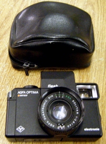 Whitehorse Historical Society Inc.
Equipment - Camera
The camera was used locally by the donorBlack electronic Agfa Optima camera with sensor and flash in a black vinyl carry zippered carry case. The lens is set in a recessed surround containing a light meter. The surround can be turned to indicate distance for personal, group and scene photos. The lens is described as Alpha Paratronic Dir Solitar 1.2/40. The back opens to contain the film. The orange button is to activate the flash, which folds down to the lens.photography, cameras -
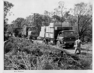 Southern Sherbrooke Historical Society Inc.
Photograph - Trucks for scout jamboree held on Montague Orchards in Narre Warren North
Black and white photo shows three trucks laden with wooden crates, driving down a dirt track with small trees behind and cut branches in the foreground. A man wearing a t-shirt and gingham shorts is guiding the trucks. Another man stands further back along the track. A fourth vehicle is in the distance. The first truck appears to be the same as in 027/283. On the lower frame of the photo is printed Beaver photographic -
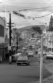 Ballarat Tramway Museum
Photograph - Digital image, Peter Bruce, "Bridge St", 1970s
Yields information about the Bridge St landscape looking east.Digital image of a view looking east along Barkly St from Grenville St showing a tram a the intersection of the Mt Pleasant and Victoria St lines (Stones Corner). Has the shops on both side of the street in view. In the far distance is the Caltex service station. Photo taken by Peter Bruce 1970's and 1971, prior to the closure of the Ballarat tramway system. Peter's Title of image: "Bridge St"trams, tramways, ballarat, bridge st -
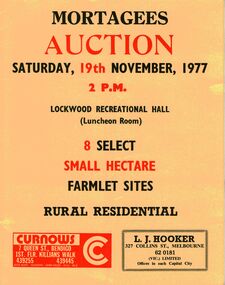 Bendigo Historical Society Inc.
Document - IAN DYETT COLLECTION: AUCTION CATALOGUE - MORTAGEES AUCTION - SMALL FARMLET SITES
Folded yellow card for an auction sale at the Lockwood Recreational Hall on 19th November 1977 of 8 Small Hectare Farmlet Sites. Contains a sketch of the 8 lots and location of named roads. Another sketch shows location of nearby towns and the distance to them. Also a small amount of information about Lockwood. Auctioneers and sole selling agents in conjunction - Curnows and L. J. Hooker (Vic.) Limited.business, auctioneers, j h curnow & son pty ltd, ian dyett collection - auction catalogue - mortagees auction - small farmlet sites, lockwood recreational hall, curnows, l j hooker, ian dyett, fred dyett -
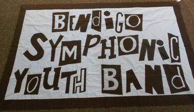 Bendigo Historical Society Inc.
Textile - Banner
Large banner for Bendigo Symphonic Youth Band. Fabric block letters have been individually machined onto a sky blue background to form the band's name. At the top of the banner there is an insert for a rod to enable the banner to be hung or carried in a march. Two selected letters - O and B have spotted fabric within the outlined letters so that these stand out at a distance. The banner has a black fabric backing.bendigo bands, youth bands, bendigo symphonic youth band, band banner -
Beechworth RSL Sub-Branch
Memorabilia - Ashtray - trench art
Item acquired by Pte B.A. Bistrow 5848 6th London Regiment during war service in France during WWIA ashtray made from the bottom part of 100 mm artillery shell; there are three groves spaced at equal distance on the rim of ashtray' small arm cartridge shell is soldered to internal primer house of the artillery shell ; on the shell rim there are three files groves that may be considered decorative with radiating file marks on side of the ashtray assumed to had been made when filing the groves on the shell rim.marking relating the artillery shell around the base are; 18 Pr II (roman numerals for 2) clockwise from that are; LOT 193; B5; CF - 7/16; abd EWBC