Showing 4576 items
matching historical maps
-
 Glen Eira Historical Society
Document - Clarence Court Elsternwick
This file contains one item pertaining to Anglican Homes for Elderly People in Clarence Court, Elsternwick: 1/A bundle of documents, including a list of the names of office bearers, the annual report and financial statement, the balance sheet, the income and expenditure statement and the auditor’s report for the year ending 31 December 1987, plus a hand-drawn map showing the location of the Court.elsternwick, clarence court, st. catherine’s, trinity court, mcgregor j. mrs., arden d. mr, howlett g. mr., riley d. mr., hare j. mrs., curzon-siggers e. mrs., guy j. mr., hurst p. mr., lang d. dr., rowland a. mr., weickhardt g. mr., buegg m. mrs., henham f. miss, wright l. mrs., sister james walter, nellor w. reverend, davis r. reverend, hislop j. reverend, cleary r. reverend, yelland r. mr., danby bland proven + co. -
Glen Eira Historical Society
Document - Moorabbin Transit
This file contains one item: 1/A Moorabbin Transit printout of the bus timetable information for Route 822, effective 05/08/2002. Includes a description and a map of the route.princes highway, murrumbeena road, sydney street, hobart road, neerim road, crosbie road, north road, malborough street, stockdale avenue, gardeners road, quinns road, east boundary road, murrumbeena, bentleigh east, buses, bus stops, bus services, transport -
 Federation University Historical Collection
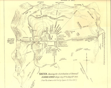
Plan, Sketch of Elands River Siege, 1900
Plan based on the field notes of Captain David John Ham, V.B.C. For article written by Ham on the event, see http://trove.nla.gov.au/ndp/del/article/9542500 For obituary of Ham, see http://trove.nla.gov.au/ndp/del/article/11023251Sketched paper map of forces' distribution at the Elands River siege. Map details surrounding hills, roads, rivers, and names all soldiers involved in siege. boer war, map, sketch, victorian's bushmen contingent, hocking, fowles, methuens, david john ham -
 Federation University Historical Collection
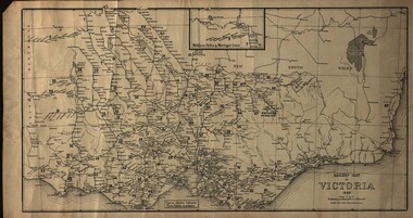
Map, Railway Map of Victoria, 1930
Cardboard map of Victorian railway system in 1930. Maps out all train-lines in Victoria and into New South Wales. map, railway, train-lines, victoria, victorian railways, railway lines -
 Federation University Historical Collection
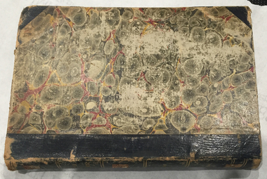
Book, Selection of Geological Publications, 09/1866
This book was owned and used by Professor Ferdinand M. Krause of the Ballarat School of Mines.Ferdinand Krause was a renowned teacher at the Ballarat School of Mines. He also produced many important Geological Maps. This book has seven reports that Krause had bound together for his own use. Half black leather bound book with hand marbled paper cover. Marbling on cover is grey, maroon and darker grey with gold bands on black leather spine. The book contains 7 papers on various subjects associated with ores. The book includes: 1. Auriferous, Leads, & Silver Ores at Upper Hungary - G.H.F. Ulrich, 1868 2. Nuggetty Reef, Maldon, Victoria - G.H.F. Ulrich, 1866 3. Internal Communication - Lieut. Amsinck, 1856 4. Roads for Victoria - William Macredie, 1856 5. Mining & Mineral Statistics of Victoria - Robert Brough Smyth, 1866 6. Physical Geography & Geology of Victoria - R.C. Selwyn, 1866 7. Mineralogy of Victoria - G.H.F. Ulrich, 1866 Leather component is black with gold bands on spine with "Silver Ores etc" written on spine. 'G" on square cream paper at top of spine; "2" on square cream paper on middle of spine; and "3" on square cream paper on bottom of spine. Inside front cover on red paper rectangle near spine "bound by W. PAUL 17 Lydiard St BALLARAT" "Ferdinand M Krause C E" handwritten in black ink on title page of first paper (right hand side)treatment, auriferous, lead, silver ores, nuggetty reef, maldon, victoria, internal communication, roads for victoria, mining, mineral statistics, geography, geology, mineralogy, ulrich, amsinck, selwyn, ferdinand krause, macredie -
 Federation University Historical Collection
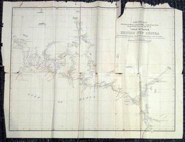
Map, British New Guinea, 1893, 1893
The map was surveyed by ship compass, distances by estimation or rate of launch by officers of the Government ; supervised and compiled by J.B. Cameron, G.S. March 1893. This map was in the possession of Charles Carty Salmon (1860-1917), politician, born on 27 July 1860 at Amherst, Victoria. (http://adb.anu.edu.au/biography/salmon-charles-carty-8328 ) Although living in Melbourne Charles Carty Salmon kept property at Talbot. The property was leased, then purchased by the donor's family. A copy of "The Goulburn Weir and its Dependent System of Works" and this map (in a government envelope addressed to Salmon) were left at the property. See http://nla.gov.au/nla.map-rm1894-1 .1) Sketch map showing the rivers and an outline of the coast from Long. 144?30'E. to Long. 146?30'E. Gulf of Papua British New Guinea Scale [ca. 1:316,800]. .2) Large envelope addressed to The Hon Charles Carty Salmon M.P., Talbot, Victoria. The map was folded and stored in this envelope. Map extending from Port Bevan to Kaikavau Pt, showing rivers and notes on soil and vegetation. Relief shown by hachures and spot heights. Also available in an electronic version via the Internet at: http://nla.gov.au/nla.map-rm1894-1 .1) "Enclosure in Despatch No. 32 of 3rd May 1893 - Appendix G.". "Map no. 4 British New Guinea report 1892-93". .2) "This envelope can only be lawfully used by Government Officials on public business. Any use by Officials on private business, or by others under any circumstances, is punishable." "Commonwealth Celebrations. General Secretary's Office, Melbourne."carty salmon, charles carty salmon, new guinea, j.b. cameron -
 Federation University Historical Collection
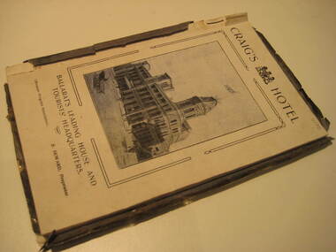
Book, Ballarat Progress Association, Beautiful Ballarat, 1912, 1912
Tourist booklet.Soft covered book of eighty pages. Includes fold out map of Ballarat and illustrations such as Sturt Street, Ballarat Town Hall, Ballarat East Town Hall, Lake Wendouree, Botanical Gardens, statues, Ballarat Grammar School, Ballarat College, St Patrick's College, Ballarat Agricultural High School, Ballarat School of Mines and Industries, Bo Peep Falls, Cobb and Co., Lal Lal Falls.churches, education, schools, gold, ballarat, mining, tourism, railway, craig's hotel, cobb and co, wallace buter factory, the taffy king, eureka stockade, gordon brothers big store, ballarat east town hall, ballarat brewing company, lake wendouree, lake view hotel, ballarat botanical gardens, statues, boer war monument, club hotel, ballarat east gardens, new imperial gold mine, camp hotel, lal lal falls, bo beep creek -
 Federation University Historical Collection
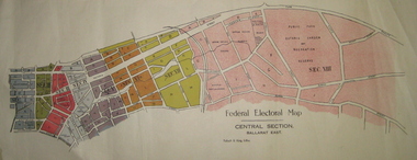
Plan - Plans, Tulloch & King, Federal Electoral Map Subdivision of Ballarat, c1901
It is thought that these are the first federal electorial plans for the Subdivision of Ballarat. The first member of Ballarat was Alfred Deakin.May of the Federal subdivision of Ballarat, with each section depicted in a different colour. The plans include Lake Wendouree, Central Ballarat subdivision; Soldiers Hill subdivision; Ballarat East subdivision, and Central Section Ballarat East, including the Ballarat East Botanic Garden .ballarat, federation, alfred deakin, elections, plan, electoral division, electoral map, polling -
 Federation University Historical Collection
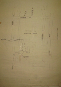
Plan, Sovereign Hill Recreation Reserve and Surrounds
This map was probably produced around the time that the Sovereign Hill Museums Association was established. A simple plan with black marking on paper. It shows the Sovereign Hill Recreation Rerserve, including the swimming pool located near the Sovereign Hill Trig Point, showers, toilets, kiosk, bandstand and pine trees. The plan also depicts the Ballarat East streets surrounding Sovereign hill, including Geelong Road, Magpie Street, Stephens Street, Tregurtha Street, Dunn Street, Bourke Street, Gladstone Street and Robertson Street. The scale is 2 chains to 1 inch.sovereign hill, swimming pool -
 Federation University Historical Collection
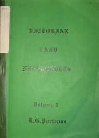
Book, Roger G. Porteous, Victorian Land Freeholders
Green soft covered book with green tape spine. The book includes names and dates of the first land freeholders listed on Ballaarat and district Parish Maps. -
 Federation University Historical Collection
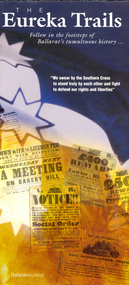
Brochure, The Eureka Trails, c2005
The brochure gives information on the Eureka Stockade which took place on 03 December 1854.Double sided A3 brochure with colour reproductions of scenes related to the Eureka Stockade. The brochure includes a map showing the route the Government forces took on their way to the Eureka Stockade as well as sites of interest to Eureka. eureka, eureka stockade, diggers' trail, trooper's trail -
Federation University Historical Collection
Plan - Plan (copy), Melbourne Road Ballaarat, 1857
This map shows the vicinity of the site of the Eureka Stockade. A3 black and whole photocopy of a plan of Ballarat's Melbourne Road. The plan shows Melbourne Road, Proposed Melbourne Road (later Eureka Street), Chamberlain Street, Queen Street, Allotments between Rodier Street and Stawell Street (William Collard Smith, J & T Oddie, F.A. Edward A. Wynne, David Fitzpatrick, Robert Walsh, Charles Spencer, Alfred Lester, Free Trade Hotel)william collard smith, oddie, wynne, fitzpatrick, walsh, spencer, lester, free trade hotel -
 Federation University Historical Collection
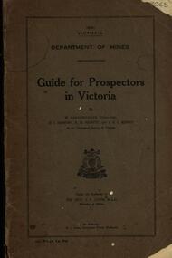
Book, Guide for Prospectors in Victoria, 1931, 1931
The handbook was intended for those with little experience who wanted to prospect of fossick.Grey soft covered book of 90 pages. Includes fold out map of a portion of Victoria showing auriferous areas and mineral localities. Also show Counties of Victoria and localities of minerals such as tin, antimony, copper, silver lead, Malybdenite, tungsten ores, manganese, platinum, osmiridium and iron. Chapter heading s include: working alluvial deposits, equipment, geology of Victoria, gold deposits, quartz reefs, indicators, economic minerals, assistance to prospectors, Miners' Right, mining bye-law, mining leases, forest regulations and glossary. Descriptions are given of a god dish, puddling tub, cradle, puddling machine, ground sluicing, boring, windlass, whim, hand dollying, sweeping, California pump, and wing dam.mining, baragwanath, gold, prospector, geology, quartz reefs, alluvial deposits, indicators, victorian goldfields, miners rights, mining leases, forest regulations, sluicing, sluice box, puddling machine, miner's cradle, whim, whip, california pump, gold nuggets, saddle reef, ballarat indicators, state batteries -
 Federation University Historical Collection
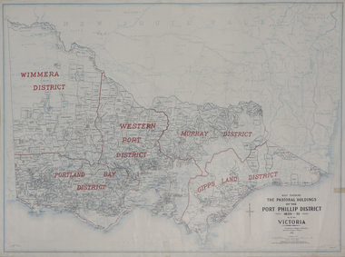
Plan, Map Showing the Pastoral Holdings of the Port Phillip District 1835-1851 Now Victoria, 1932, 1932
Another name for Pastoral Holdings is squatting runs. Information on Alfred Stephen Kenyon of the Historical Society of Victoria can be found at http://adb.anu.edu.au/biography/kenyon-alfred-stephen-6936/text12035 Map of Victoria showing the boundaries of the Port Phillip District (Victoria) pastoral boundaries. pastoral holdings, squatters, squatting, victoria, land, crown lands, a.s. kenyon, alfred stephen kenyon -
Federation University Historical Collection
Plan (copy), Frederick Proeschel, Map of the Roads to all the Gold Mines in Victoria, 1853
The map was pirated from Frederick Proeschel's "Pocket Map of the Roads to all the Gold Mines in Victoria" issued earlier in 1853.Digital file of the Map of the Roads to all the Gold Mines in Victoria. The map has been coloured to show routes to the Victorian goldfields from Melbourne and Geelong.frederick proeschel, proeschel, gold, mining, philp -
 Federation University Historical Collection
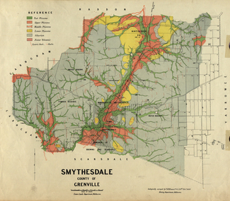
Map, Smythesdale, County of Grenville, 1888, 1889
The map maker, Ferdinand M. Krause, was a professor at the Ballarat School of Mines. This land was printed form the Crown Lands Department, Melbourne. Coloured map of the County of Grenville. The edge has been taped. The scale is 40 chains to 1 inch. The map is accompanied with a foolscap sheet printed by the Mines Department in 1898. It is a Report on the Parish of Smythesdale by F.M. Krause and includes information on the water reserve, worked quartz veins, Watson's Hill, Surface Hill and Sugarloaf Hill, Haddon, Trunk Lead and the Crucible Shaft. smythesdale, krause, f.m. krause, ferdinand krause, nitingbool, watson's hill, surface hill, sugarloaf hill, haddon -
 Federation University Historical Collection
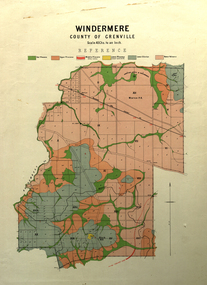
Map, Windermere, County of Grenville
Coloured geological map of Windermere, County of Grenville. Scale is 40 chains to 1 inchwindermere, grenville, krause, plan, map -
 Federation University Historical Collection
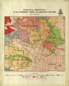
Map, Geological Sketch Map of the Werribee Gorge and Adjacent Country, 1914, 1914
A coloured geological sketch map of the Werribee Gorge, Bacchus Marsh, Rowlesy, Darley, Parwan. The scale is 1 mile to 1 inchwerribee gorge, bacchus marsh, darley, parwan, w.e. bennett, bennett, r.a.f. murray, c.c. brittlebank, rowsley -
 Federation University Historical Collection
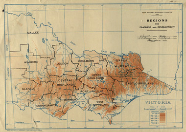
Map, Victoria: Regions for Planning and Development, 1944, 1944
This map was produced for the State Regional Boundaries Committee Two colour map of Victoria showing the regions for planning and development. The regions are Central Highlands, Mallee, Wimmera, Glenelg, Corangamite, Barwon, Loddon, Goulburn, Upper Goulburn, Upper Murray, East Gippsland, West Gippsland, Port Phillip.central highlands, mallee, wimmera, glenelg, corangamite, barwon, loddon, goulburn, upper goulburn, upper murray, east gippsland, west gippsland, port phillip, victoria, m4486 -
 Federation University Historical Collection
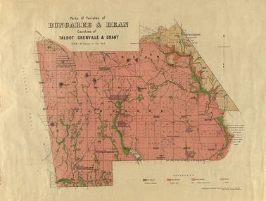
Plan, Bungaree and Dean Parish and Geological Plan, 1890, 07/1890
Ferdinand M. Krause was a Professor at the Ballarat School of Mines.Geological and Parish Map of parts of the Parishes of Bungaree and Dean in the Counties of Talbot, Grenville and Grant. The scale is 40 chains to one inch. bungaree, deen, krause, f.m. krause, musk creek, clarkes hill, badger hill, beale's reservoir, acquainted. -
 Federation University Historical Collection
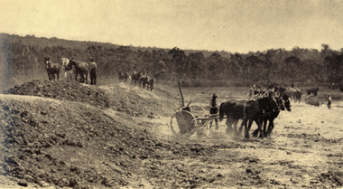
Book, Yallourn, 10/1962
In the foreword the Chairman and General Manager, W.H. Connolly, wrote: "Australia's progress since the Second World War has been remarkable - and nowhere more so than in Victoria. Although the smallest pf the mainland States, Victoria is today the most highly industrialised, the second most populous and the most rapidly developing State in the Commonwealth. Many factors have contributed to this growth, bu the one of greatest importance is the vast wealth of easily extractable brown coal in the Latrobe Valley which is the source of Victoria's electricity and a major part of its solid fuel. ... "White and green soft covered book of 34 pages with black & white and coloured illustrations. The book includes starts with an historical section, and includes information the open cut, Yallourn Power Station, Yallourn Briquette Works, the town, Morwell Open Cut, and includes a map of the Latrobe Valley Brown Coal resources.yallourn, connolly, open cut, power station, kernot, coal, briquette, lyle, monash, yallourn open cut, yallourn power station, yallourn briquette works, morwell open cut, hazelwood, brown coal, gippsland, horses, turning sod -
 Federation University Historical Collection
Map, Municipality of Ballarat East, 1857
Gold was discovered in Ballarat in 1851. This plan was created six years later and names some of the great gold locations of Ballarat East. It also shows the locality of the Eureka Stockade (1854) and the walking tracks and roads on the Ballarat East Goldfield.In 2007 this map was listed on the inaugural Ballarat Treasure's Register.Large map backed onto linen. The map has read and blue highlights, and identifies areas such as Mount Pleasant, Golden Point, White Flat, Nightingale, Malekoff, Old Post Office Hill, Red streak, Gumtree Flat, Old Gravelpits, Bakery Hill, Ballaarat Flat, The Camp, Specimen Gully, Pennyweight Hill, Warrenheip Gully, Gays Gully, Pennyweight Flat, Eureka, Black Hill, Pinchgut, Crocodile, Hit or Miss, Little Bendigo, Brown Hill, Mopoke, Cricket Reserve, Canadian Hotel, Ballarat Eastmount pleasant, golden point, white flat, nightingale, malekoff, old post office hill, red streak, gumtree flat, old gravelpits, bakery hill, ballaarat flat, the camp, specimen gully, pennyweight hill, warrenheip gully, gays gully, pennyweight flat, eureka, black hill, pinchgut, crocodile, hit or miss, little bendigo, brown hill, mopoke, cricket reserve, canadian hotel, ballarat eastm phillips, john phillips, field draughtsman, ballarat east, ballarat east map -
 Federation University Historical Collection
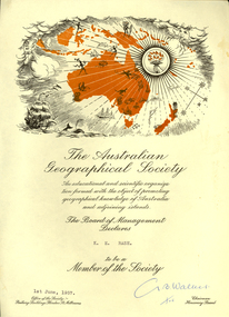
Certificate, Australian Geographical Society, Australian Geographical Society certificate made out to Keith Rash, 1957, 01/06/1957
Certificate of the Australian Geographical Society made out to Keith Rash. One printed page, map of Oceania including sailing ship, torch, map of Australia and surrounding islands. G. B. Walker (signature)rash, keith rash, australian geographical society, g.b. walker -
 Federation University Historical Collection
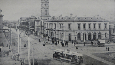
Book - Souvenir, Ballarat Progress Association, Beautiful Ballarat, 1914, 1914
Beautiful Ballarat was produced for tourists to Ballarat.Eighty six page book with soft brown cover. The book includes some historical articles and a number of black and white images and advertisements. Includes map insert.ballarat, eureka stockade, gold discovery, rowlands, lydiard street, ballarat post office, ballarat town hall, ballarat woollen mils, sunnyside woollen mill, ballarat east town hall, ronaldson bros and tippett, railway, lake wendouree, rolfe, ballarat botanical gardens, mining, new imperial gold mine, ballarat art gallery, schools, education, ballarat school of mines, ymca, provincial hotel, ballarat grammar school, rolfe cycles, cycles, bicycles, buninyong godld discovery obelisk, j.a. reynolds, w. brown and co, motor cycle, carlyon's hotel, charles morris furnishing undertaker, newlyn reservoir, y.m.c.a., unicorn hotel, golden city hotel, st andrew's kirk, george hotel, ballarat agricultural high school, st patrick's college, ballarat college, h. francis chemist, south street competitions, boer war memorial, fernery, reid's coffee palace, trout, carey motor company, herbert rolfe -
 Federation University Historical Collection
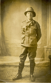
Postcard, Harold Reid, c1916
Harold Reid, dressed in Australian Army uniform poses for a photograph during World War One. Verso 'Harold Reid, taken at place where we have our maps printed.'chatham family archive, chatham, holmes, world war, world war 1, world war i, world war one, france, harold reid, reid -
 Federation University Historical Collection
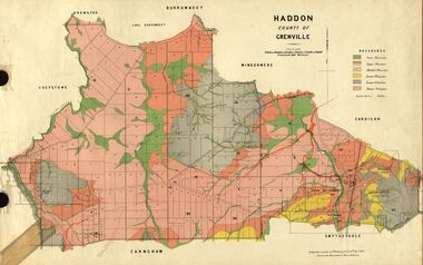
Plan, Haddon, County of Grenville, 1887, 1889
Ferdinand Krause taught at the Ballarat School of MinesGeological Map of Haddon in the County of Grenville surveyed by Ferdinand Krause. haddon, grenville, krause, ferdinand krause, cgt, lake burrumbeet, windermere, chepstowe, bailies creek, snake valley lead, nentingbool preemptice right, cardigan state forest, haddon state forest -
 Federation University Historical Collection
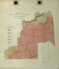
Plan - Map, Mines Department, Parish of Narmbool and part of Cargerie, County of Grant, 1892, 06/1992
This map shows the position of the homestead on the Narmbool Pre-emptive Right, volcanic craters, stock reserve, quarry and geological eras,Geological map showing Narmbool and part of Cargerie in the County of Grant in five colours, predominantly pink.narmbool, cargerie, narmbool pre-emptive right, williamson's creek, leigh river, green hill, collyer's hill, volcano, crater, krause, ferdinand krause -
 Federation University Historical Collection
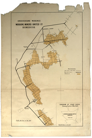
Plan, Underground Workings, Working Miners United Co. Homebush
Printed map on paper various measurements and locationsunderground workings, plan, working miners united co, homebush -
 Federation University Historical Collection
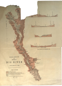
Plan, Geological Sketch Map of Portion of Big River
Printed map on paperscale, index to colours, sectionsgeological sketch map, plan, big river, mount wills, geology -
 Federation University Historical Collection
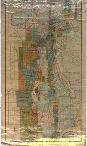
Map, Ballarat and Sebastapol Gold Mines, Late 19th Century
colored printed map on paper lined onto linen backingprinted "Rider & Mercer's Plan of the Ballarat & Sebastapol Gold Mines Scale 30 Chains to One Inch"gold mines, mine allotment map, mining leases, ballarat, sebastopol, rider and mercer, golden shaft co, prince of wales and bonshaw united, leviathan gold mines, holst and co, speedwell co, sebastopol plateau, rothschild co, tower hill co, south plateau, south star co, band of hop and albion consols, prince regent co, chenhall and co, despza, buninyong estate, one eye hully, winter's freehold, luplau plateau, e. morey, carrill's quartz